
Durrington, United Kingdom · United Kingdom
- Woodhenge is a Neolithic timber circle and henge in Durrington, Wiltshire, about two miles north-east of Stonehenge.
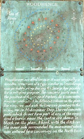
- Six concentric ovals of posts were raised in the Late Neolithic, and a bank and ditch enclosed them generations later.
- Gilbert Insall photographed the crop marks from the air, and Maud Cunnington excavated the postholes with Ben Cunnington in 1926 and 1927.
- A child was buried near the centre, and a crouched burial was cut into the eastern ditch in the early Bronze Age.
- Concrete pillars now mark the postholes, and a flint cairn marks the child's grave.
Visiting
Entry is free, and the site is open any reasonable time during daylight hours. Smoking, vaping, barbecues, and naked flames are not allowed.
History
Woodhenge is a timber circle and henge in Durrington parish, Wiltshire, about two miles north-east of Stonehenge. Six oval rings of oak posts were raised in the later Neolithic, and a bank and an external ditch were added some generations later. The single entrance faces north-east, toward the midsummer sunrise and toward Durrington Walls.
One chronology places the posts in 2635 to 2575 BC, and the earthwork probably in 2465 to 2345 BC, after a long gap. Other accounts put the ditch between 2470 and 2000 BC, or the whole monument around 2500 BC, in the same broad age as the sarsen settings at Stonehenge. The place was still in use around 1800 BC.
Grooved Ware, carved chalk, antler picks, and animal bone were set in the holes and in the ditch, along with a greenstone axe whose stone came from Cornwall. A child of about two or three was buried near the centre. The excavator thought the skull had been cleft, but the pathology report did not record that injury, and the bones were later lost. A cremation of a mature adult was placed at the foot of one large post soon after that ring was built, and a crouched burial in the eastern ditch, dated to 1760 to 1670 BC, has been called a teenager, a young man, and an adult.
The bank was known in the early nineteenth century as Dough Cover and was taken for a disc barrow. Gilbert Insall photographed the crop marks from the air in December 1925, though one account dates the recognition to 1926. Ben and Maud Cunnington excavated the rings in 1926 and 1927. Maud named the site in 1929 because the plan resembled Stonehenge, and the couple marked the holes with concrete posts and gave the land to the nation.
The monument was scheduled in 1929 and was included in 1986 in the Stonehenge, Avebury and Associated Sites World Heritage Site. The Cuckoo Stone, a fallen sarsen, lies about 500 metres to the west. In 2020 a circuit of great shafts dated to about 2500 BC was traced around Woodhenge and Durrington Walls. Faint earthworks, the concrete markers, and a flint cairn over the child's grave are what remain in the field.
Images




Detailed History
Woodhenge is a Neolithic timber circle and henge in Durrington parish, Wiltshire, just north of Amesbury and about two miles north-east of Stonehenge. It is a Class II henge: six concentric oval rings of postholes, surrounded by a single ditch and an outer bank, with one entrance on the north-east. The rings have been labelled from the outside inward. The whole setting sits in the chalk landscape that also holds Durrington Walls, the Stonehenge Avenue, and the densest concentration of burial mounds in Britain.
In 1986 that landscape was inscribed as the Stonehenge, Avebury and Associated Sites World Heritage Site, and a minor change to the boundary was inscribed in 2008. The monuments of the property were built and used across roughly two thousand years, from about 3700 to 1600 BC.
The Neolithic British Isles run from about 4100 BC to about 2500 BC, after the Mesolithic and before the Bronze Age. In the Mesolithic the people of these islands were hunter-gatherers. Early in that period Britain was still joined to the continent by Doggerland. Around 4000 BC, farming arrived.
A study published in 2019 read the ancient DNA as a mass migration at about 4100 BC. Those farmers were closely related to Neolithic people in Iberia, and through them to farmers who had moved west from the Balkans along the Mediterranean. The hunter-gatherers already living here were almost entirely replaced, and their ancestry did not rebound in the centuries that followed. What language those first farmers spoke is not known.
The earliest languages on the islands that can be named with confidence belong to the Celtic branch of Indo-European.
The Early and Middle Neolithic, from about 4000 to 2900 BC, was the age of the first farming clearance and of the great chambered tombs. Tomb building in the islands falls mostly between 4000 and 3200 BC. The tombs were shrines as well as graves, far larger than a store of bones required, and they have been compared with the long timber houses of farming communities in the Danube basin from about 4800 BC. People grew wheat and barley and still gathered hazelnuts.
Charred grape pips at Hambledon Hill show that grapes were eaten in Neolithic Wessex, either brought from the continent or grown here in a warmer climate. Houses were rectangular and wooden, so almost none survive except as foundations found near stone monuments. Between about 3500 and 3300 BC, settlement thickened on the better soils, and Wessex was one of those regions. Elm declined widely between 4300 and 3250 BC.
Farmers may have stripped the leaves for winter fodder, or cattle may have damaged the bark, and the elm bark beetle and elm disease are also in the record.
The Late Neolithic, from about 3000 to 2500 BC, changed the monuments. After more than a thousand years of early farming, a way of life built on ancestral tombs, forest clearance, and expanding settlement came to an end. Stone circles, and circles of timber, took the place of the old chambered tombs. That is the horizon in which Woodhenge was raised.
There was never one religion that can be labelled Neolithic. The variety of monuments does not collapse into a single idea. What the circles share is a new concern with open enclosures, with the sky, and with gatherings that were no longer centred on a tomb chamber.
The post rings at Woodhenge form an oval. One measured plan gives the outermost ring as about 43 by 40 metres. Another describes the timber monument as 40 metres long and 36 metres wide, and another puts the post-hole structure at about 40 metres across. One hundred and sixty-eight postholes were found.
Most of them were 0.6 to 1.2 metres across and up to 1.5 metres deep. The deepest holes are also said to have reached 2 metres, holding posts that may have stood 7.5 metres above the ground and weighed as much as five tons. The outer two rings were of smaller, closely spaced posts. Inside them stood the ring of the largest timbers, sixteen posts, each raised up a ramp.
One account gives those large posts a diameter of about 35 centimetres. The excavation record used for the new dating gives the posts of that same ring a diameter of about 0.91 metres, which is the three feet estimated at the time of the dig, and gives the posts of the two outer rings a diameter of about 0.3 metres, or one foot. Both figures are in the published record, and they do not agree. Within the large ring were three smaller ovals.
Oak charcoal from the holes has been read as sapwood from the outside of the posts. Fragments stuck to the packing suggest that the butts were charred, either to slow rot or to help shape the timber. The holes kept the pipes of posts that were left to decay where they stood, rather than being pulled out. A rough rule used for oak, fifteen years of standing life for every 50 millimetres of diameter, gives the great posts of the inner large ring about 270 years and the slighter posts of the outer rings about 90 years.
That estimate matters, because the earthwork came later.
A programme of radiocarbon dating and chronological modelling, carried out from 2019 to 2024 on antler, animal bone, charcoal, and cremated bone from the archive, places a single episode of timber building in 2635 to 2575 cal BC at 95 percent probability. The more likely parts of that range are 2635 to 2610 cal BC, or 2595 to 2580 cal BC. Taken ring by ring, the large inner ring falls in 2665 to 2565 cal BC, probably 2635 to 2575. One outer ring falls in 2690 to 2575 cal BC, with a one percent chance of 2830 to 2820, and probably in 2660 to 2615 or 2600 to 2580.
The other outer ring falls in 2665 to 2565 cal BC, again with that small chance of 2830 to 2820, and probably in 2630 to 2575. The gaps between those estimates are negligible, so the rings can be treated as one build. The original excavator thought the large ring went up first, for practical reasons. The new model does not separate the rings in time.
Other accounts give rounder dates. One places the monument at about 2500 BC, in the same broad years as the sarsen settings at Stonehenge. Another dates the ditch to between 2470 and 2000 BC and says the timber was probably earlier, with the place still in use around 1800 BC. Two older radiocarbon results on antler and animal bone from the primary ditch, measured in the early 1970s, gave 2470 to 2040 cal BC and 2390 to 2000 cal BC.
From those, the earthwork was described as around 2300 BC, a little later than the stone settings at Stonehenge. The new model puts the ditch and bank at 2555 to 2505 cal BC, which carries only a 2 percent probability, or 2495 to 2180 cal BC, which carries 93 percent, and probably at 2465 to 2345 cal BC. The enclosure therefore followed the posts by 75 to 440 years at 95 percent probability, and probably by 145 to 280 years. That is a long gap, not a short interval, and it rejects the idea that bank, ditch, and posts were one phase.
Grooved Ware under the bank had already been used to argue that the earthwork was later. The dates now support that order.
By the time the bank and ditch were cut, the outer posts had probably already rotted away. The thicker timbers of the large ring may still have been standing. The earthwork is an oval ditch with an external bank and a single north-eastern entrance. One plan gives the ditch as flat-bottomed, 2.4 metres deep and up to 12 metres wide, the bank about 10 metres wide and 1 metre high, and the whole monument, bank and ditch included, about 110 metres across.
Another account gives the henge as about 85 metres across, and another as about 90 metres, or 295 feet. A trench cut in 1970 found the ditch on that line only 4.4 to 5.1 metres wide, with a buttress of unexcavated chalk about a metre high almost crossing the cutting. The width depends on where the ditch was measured. The entrance faces Durrington Walls.
The outer rings seem to have had an entrance on a similar line. The henge entrance itself may not share the axis of the inner timber ovals, so the sky alignment may belong to the posts, or only to the inner rings, and not to the later earthwork.
The oval is aligned north-east to south-west, the same axis Maud Cunnington noticed at Stonehenge: summer solstice sunrise one way, and winter solstice sunset the other. The ground to the south-west rises and blocks a view of the midwinter sunset. To the north-east the view is open. The likely sightline of the timber setting is therefore the midsummer sunrise.
Around the middle of the third millennium BC, monuments with precise alignments to the sky were built in this landscape, and then that kind of building stopped. Woodhenge belongs to that short floruit, alongside the great works at Stonehenge, Avebury, and Silbury Hill.
Maud Cunnington read the posts as an open-air monument. Soon afterwards Stuart Piggott argued that they had held up a large communal building, and that roofed reading was accepted for many years. Work at The Sanctuary, a comparable timber setting near Avebury, later showed that individual posts there were replaced, which fits free-standing timbers better than a single roof. The new dates at Woodhenge go further.
The rings here seem to have been put up once, not renewed. That is a different history from The Sanctuary, where replacement has been tied to rites of decay and remembrance. Another survey of the early metal age still notes that some researchers have treated Woodhenge as a roofed building, while the usual view is that it stood in the open. The same uncertainty has been attached to the Southern Circle inside Durrington Walls.
The things left in the ground are the clearest evidence of how the place was used. The pottery is Grooved Ware, the style tied in one account to the Middle Neolithic, together with later Beaker sherds. With the pots were carved chalk, including chalk axes, two chalk cups, perforated pieces, and incised blocks; antler picks; animal bone; flint flakes and arrowheads; marine shells; and a polished greenstone axe whose stone came from Cornwall, about 290 kilometres away. A flint awl, a toothed saw, and a fabricator were among the tools.
The fabricator was used with iron pyrite to strike sparks. There was also a bone pin. Objects were set deliberately in the ditch on either side of the entrance, around the posts, and in the hollows left after the posts had rotted. Sherds, antler, worked chalk, and animal bone favour the eastern half.
About 65 percent of the sherds lay to the east. Flint implements and animal bone cluster in the large ring, with less toward the outside and the inside. Antler is more common in one of the middle rings, and within the south and east. Worked chalk is confined to the eastern sector.
Pig bone is restricted to the three outer rings. Cattle bone lies substantially in the inner rings. Human bone also lies toward the interior. The pattern reads as an east-west order, not as casual rubbish, though some of the material is the debris of flint knapping and of meals.
Before the bank was raised, three pairs of pits on the site were sealed beneath it. Their position suggests they belonged to the choice of the spot. They were filled with charcoal-rich soil and burnt flint. Two of them held unburnt pig or cattle bone in great quantity, and sherds of Grooved Ware.
One held pure wood ash and thirteen flint implements, including two transverse arrowheads. That is domestic refuse placed on purpose. In 2006 a narrow surviving strip of buried soil under the eastern tail of the bank, 5.4 by 3.2 metres, was found to run into an oval tree-throw 3.5 by 2.5 metres and half a metre deep. The upper fill held a large quantity of animal bone.
A cattle bone from it is a limit before which the bank was not built. The 2006 cutting survived only because earlier trenches, one from 1926 and one from 1970, had already taken the rest of that line.
Two people, and perhaps more, were buried in the monument, and the accounts of them do not match in every detail. Near the centre, just south-west of the innermost ring, was the crouched burial of a child. The grave was oval, cut 0.3 metres into the chalk, with the body at the south end, facing north-east, and with no grave goods. The child is described as two or three years old, and as about three.
One record leaves open the possibility that the child was a girl. Maud Cunnington took the broken skull as evidence that it had been cleft before burial, and read the grave as a dedicatory sacrifice. The pathology report does not mention a cleft. A later reading is that the weight of the soil broke the skull over time.
After the excavation the bones were taken to London, where one account says they were destroyed in the Blitz, so they could not be examined again. Another account says the bones appear to have been lost after the dig, and that the grave is likely to be of a similar date to the burial in the ditch. A flint cairn now marks the place.
A separate cremation was found in a posthole of the large ring, a hole 1.52 metres deep and 1.3 metres across. It held 523 grams of calcined bone from the femoral shaft of a mature adult, placed at the foot of the upright while the post was still standing. The cremation falls 1 to 65 years after that ring was finished, at 95 percent probability, and probably within 1 to 25 years. Fragments of skull and a tooth from the same hole were also recorded as a cremation.
South of the centre, another pit like a grave held charcoal, ash, and a few burnt flints along its middle, a deposit rather than a hearth. Single pieces of human skull lay in the ditch. Part of a radius, and fragments of a child's jaw and teeth, lay in two other places. Romano-British pottery occurred in the ditch in three places, and in one of those places it lay in the same layer as Beaker pottery.
In the eastern ditch, opposite the entrance, a grave was cut below the ditch floor. It held a crouched body. That person is described as a teenager, as a young male, and as an adult. The burial has been dated to between 1760 and 1670 BC, in the early Bronze Age.
The monument was therefore still receiving the dead centuries after the posts went up, and after the bank and ditch.
The early metal age is Bronze Age Britain. Dates for its start are not agreed. Some put it at about 2500 to 2200 BC, some at 2200 BC, and some as late as 2000 BC. It runs on to about 800 BC, and then the Iron Age.
The years from 2500 to 2000 BC are often called a Late Neolithic and early Bronze Age overlap, because the boundary is hard to draw. Some archaeologists mark a copper age in the twenty-fifth to the twenty-second centuries BC. Others do not, because copper was used only on a small scale. Around 2500 BC the Bell Beaker pottery style arrived, with flat axes and a new habit of burying individuals rather than gathering the dead in shared tombs.
Between about 2400 and 2000 BC, about 90 percent of the older farming ancestry in Britain was replaced by ancestry related to steppe herders, closest to Beaker people of the Lower Rhine. After that change, the population of Britain had, for the first time, ancestry and pigmentation closer to people in Britain today. Isotope work on early Bronze Age teeth from graves around Stonehenge indicates that at least some of the newcomers came from the area of modern Switzerland. The authors of the genetic study linked the Beaker spread with the arrival of Celtic language.
That claim sits beside the older uncertainty about when Celtic was first spoken here.
The main early Bronze Age culture of central and southern Britain is the Wessex culture. Britain was the first region in Europe to adopt tin-bronze completely, in 2200 to 2100 BC, after a stage of copper and arsenical bronze. Cornwall and Devon held large reserves of tin, and the south-west has the earliest evidence in Europe for the exploitation of tin ore. Henges already standing were taken up by the new communities.
Woodhenge has been placed in the early Beaker period or just before it. The ditch burial of 1760 to 1670 BC, and the continued use of the site around 1800 BC, belong to the generations after that change, when the dead were more often buried alone, sometimes with a beaker, under round barrows.
Woodhenge was not alone on this stretch of the Avon. About 70 metres to the north, the Southern Circle was found in 1966 inside the great enclosure of Durrington Walls. One account puts the enclosure itself about 70 metres away. The Southern Circle is aligned on the midwinter sunrise, so the two timber monuments may have been used at different points in the year.
People gathered at the Durrington settlement from long distances to feast and to mark midwinter, and the huge bank there was built afterwards. Woodhenge lies outside that bank. A southern entrance through the Durrington earthwork may have joined the two. The plan and the scale of the Woodhenge rings resemble the Southern Circle, and both resemble the third phase of stone settings at Stonehenge.
They can be read as parts of one ritual landscape, in use at the same time, though the Stonehenge dates are not precise enough to prove the overlap. At Stonehenge few objects were left, and the place seems to have been kept clean. At Woodhenge objects were deposited, and movement around the rings may have been prescribed. Butchered pig bone has been used to argue that feasting belonged with the timber sites, and that Stonehenge was for the ancestral dead rather than for the living.
The ring-by-ring pattern is more exact than that contrast: pig in the outer rings, cattle inward, and human bone inward as well.
The Cuckoo Stone is a fallen sarsen in the field about 500 metres west of Woodhenge, the same kind of stone as the largest stones at Stonehenge. Durrington Walls lies to its north-east, and Stonehenge about 2.5 kilometres to the south-west. Richard Colt-Hoare marked it on his map of 1810. The nearest other sarsen then known was one found inside Woodhenge during the excavations of 1926 to 1928.
In 2007 the stone was excavated as part of the Stonehenge Riverside Project. It had once stood in a pit immediately to its west. It began as a natural stone, and sometime before 2000 BC it was set upright. A wooden post had stood in that pit first.
Around 2000 BC the Cuckoo Stone became the focus of several cremation burials. In the Roman period a rectangular building was put up to the south-west. Pits and a scatter of coins suggest that the building was a small shrine. The stone and the timber circle were neighbours for a very long time, from the late Neolithic into the Roman centuries.
In 2020 a ring of great shafts was traced around Durrington Walls and around Woodhenge. The ring is about 2 kilometres wide. The shafts are up to 10 metres across and 5 metres deep, and they have been dated to about 2500 BC. Up to twenty have been identified, and there may once have been more than thirty.
They were first taken for natural hollows in the chalk, of the kind called solution hollows. Only when geophysical survey across the wider landscape, made for the Stonehenge Hidden Landscapes Project, showed them as a circuit could they be joined into one monument. An internal line of posts may have run with them. The circuit has been read as a boundary that guided people toward the enclosures and warned others not to cross.
Bone recovered near the base of one shaft dates the start of its filling. The circuit is larger than any comparable prehistoric monument then known in Britain. It places Woodhenge inside a sacred area far bigger than the bank a visitor can still see.
The earthwork was known before anyone understood the posts. In the early nineteenth century it was called Dough Cover and was thought to be a disc barrow of the Bronze Age. In December 1925, Squadron Leader Gilbert Insall, flying near Durrington, saw strange marks in a field of wheat. His photograph showed dark spots, concentric rings, and other marks in the same field.
He came back the next year and photographed them again. One account dates the recognition of the henge to 1926 rather than 1925. Some writers gave the discovery to O. G.
S. Crawford, who was then Archaeology Officer for the Ordnance Survey and, with Alexander Keiller, was recording Wessex from the air. Crawford himself credited Gilbert Insall.
Excavation began in July 1926. Ben and Maud Cunnington, their nephew Robert Cunnington, and a small gang of workmen spent fifteen weeks on the site over the next two years. The seasons were 1926 and 1927. Other accounts carry the dig through 1928 or to 1929.
They trenched the whole interior and cut the bank and ditch on the north, east, south, and west. The dark spots were postholes. The rings were the bank and ditch. It was the first multi-ring timber circle of the late Neolithic to be excavated, and the trenching of a timber plan on that scale had not been done before.
In 1929 Maud Cunnington published the report and named the site Woodhenge, because the plan had so much in common with Stonehenge. The couple bought the land, set painted concrete posts in the holes so that visitors could see the plan, and gave the site to the nation. It was scheduled as an ancient monument in 1929.
Edward Benjamin Howard Cunnington, recorded as Ben Cunnington (archaeologist), lived from 1861 to 1950. He was the great-grandson of William Cunnington, the antiquary who had opened many barrows around Stonehenge in the early nineteenth century, and he was the fourth generation of the family to record Wiltshire's past. His father, Henry Cunnington, was a wine merchant. Ben worked as a journalist and then joined that business.
For sixty years he was the unpaid honorary curator of Devizes Museum. One account says he held the post from 1887. In 1889 he married Maud Pegge. Their son Edward was killed in the First World War.
On a dig, Ben hired the workmen, helped to open the trenches, and received visitors. He died in 1950.
Maud Cunnington was Maud Edith Pegge, born on 24 September 1869 at Briton Ferry in Glamorgan, and she died on 28 February 1951. Her mother was Catherine Milton Leach. Her father, Charles Pegge, was a doctor who ran Vernon House, the last privately owned asylum in Wales. She was one of seven children.
Her older brother Edward Pegge became a doctor and a Welsh international rugby player. She was educated briefly at Cheltenham Ladies' College. From 1897 she did rescue work ahead of building in Wiltshire. With Ben she excavated Knap Hill, the first known Neolithic causewayed enclosure; the Iron Age settlement at All Cannings Cross; West Kennet Long Barrow; Figsbury Ring; Woodhenge; and The Sanctuary on Overton Hill.
The Sanctuary had been lost since William Stukeley saw it in the eighteenth century. They bought that site as well as Woodhenge and gave both to the nation. In 1912 she and Ben supervised the re-erection of one of the two surviving Longstones in the Beckhampton Avenue, which had fallen the year before, and of a fallen stone on the West Kennet Avenue. At the Beckhampton Cove she found a middle-aged man buried with a beaker, since dated to 2385 to 2230 BC.
Their first joint excavation had been an early Bronze Age burial at Manton in 1906, which Maud wrote up, and that division of labour lasted: she chose what to dig, supervised the workmen, studied the pottery and the other finds, drew the record, and wrote the report. In 1931 she became the first woman president of the Wiltshire Archaeological and Natural History Society. She published a short handbook, Avebury: A Guide, in 1931, and a children's guide to the museum at Devizes.
Gilbert Insall was Group Captain Gilbert Stuart Martin Insall, born on 14 May 1894 and died on 17 February 1972. He won the Victoria Cross, and he is the only person both to have received that award and to have escaped from a German prisoner-of-war camp in the First World War. He was commissioned as a second lieutenant in the Royal Flying Corps on 14 March 1915, and he was appointed a flying officer on 16 July 1915. On 7 November 1915, aged twenty-one and serving with 11 Squadron, he was patrolling near Achiet-le-Grand in a Vickers F.B.5 Gunbus, number 5074, with First Class Air Mechanic T.
H. Donald as his gunner. They forced an Aviatik two-seater down into a ploughed field, fired on the crew as they scrambled clear, and dropped an incendiary on the German machine. Flying back at about 2,000 feet, Insall crossed the trenches under heavy fire.
The petrol tank was hit. He landed about 500 yards inside Allied lines. The aircraft was shelled on the ground. During the night the two men repaired it by torchlight, and at dawn he flew it home.
The citation was published on 23 December 1915. He could not receive the Cross then. On 14 December 1915 he and Donald were wounded and captured after an engagement with Hauptmann Martin Zander and his gunner. Insall was promoted to lieutenant on 1 April 1916 while a prisoner.
He escaped on his third attempt, on 28 August 1917, and crossed the Dutch border on 6 September. The pilot who later photographed a wheat field at Durrington was already a decorated airman. The crop marks were a second career, not his first.
In June 1970 John Evans and Geoff Wainwright cut a trench through the bank and ditch on the south-eastern side. The cutting is described as 27 metres long, and as 2 metres by 27 metres. One account dates a ditch excavation that found the antler to 1967. On the rock floor of the ditch, in an outer bay formed by the chalk buttress, lay a pile of ten red-deer antler picks.
The tine tips were smoothed by use, and one pick was battered behind the burr. They had been used to dig the chalk and were then thrown down together. A photograph of finds from the ditch bottom shows five antler picks, a smaller number than the pile of ten. Mollusc shells in the ditch fills and in the buried soil under the bank gave an environmental sequence for the monument and the ground it covered.
Those 1970 samples, together with a later measurement on animal bone, were for a long time the only scientific dates.
The 2006 return, under the Stonehenge Riverside Project, was small because the old trenches had already emptied most of that slice of buried soil. It confirmed the tree-throw and the bone under the bank tail. One account of excavations in 2006 says that at least five standing stones stood on the site, arranged as a cove. The history of the monument as now told on the ground says that at least two large sarsen stones were added on the southern side, set between pairs of posts, perhaps after the timbers had rotted.
The 1920s plan recorded two possible stone-holes in the southern part of the rings, between posts of the second and third rings. The number of stones is therefore two in one account and at least five in another. The concrete pillars visitors see are modern. They are not the sarsens.
Twenty-two radiocarbon measurements now relate to the site: eight on antler, two on animal bone, one on calcined human bone, and eleven on charcoal. Duplicate measurements on charcoal from the same holes agreed closely enough to be combined. Duplicate measurements on one antler from an outer-ring hole did not agree, and both were left out of the final model because a single object cannot have two ages and there was no independent way to choose. Antler from the ditch floor was modelled as a group that builds toward the end of the digging, on the view that tools in the bottom of a ditch mostly belong to the last stage of the work, with a few older pieces mixed in.
Animal bone from the primary rubble was treated only as a limit after which the upper filling accumulated, because the bones might not all be of one age. The result is the two-phase monument already described: an aligned timber oval of the twenty-seventh century BC, wrapped later by a bank and ditch, perhaps in the twenty-fifth or the twenty-fourth century. The astronomical use of the posts was probably short. Once the outer timbers had gone and the bank was up, the bank itself may have blocked the solstitial view.
What remains is quiet. The earthworks are faint, lowered by cultivation. The concrete posts pick out the ovals. The flint cairn marks the child.
Some of the finds, the chalk cup, the chalk axe, the flint tools, the cattle bone, the bone pin, and the Grooved Ware, are shown at the Stonehenge visitor centre, on loan from the museum in Devizes, where the archive of the excavation is kept. Woodhenge changed the study of this landscape because it was seen first from the air, dug as timber rather than as stone, and later shown to have been built twice, posts and then earthwork, rather than in a single season of work. It also changed the ground itself. For a few centuries a ring of oak stood on the midsummer axis.
Then a bank and a ditch enclosed whatever posts were left. People brought pots, antler, chalk, and the dead. Much later a pilot saw the plan in a ripening field, and the excavators who named it gave it to the public.
Sources
- Woodhenge — Wikipedia
- History of Woodhenge — English Heritage
- Woodhenge — English Heritage
- Woodhenge, Durrington, Wiltshire: Radiocarbon Dating and Chronological Modelling — Historic England
- Stonehenge, Avebury and Associated Sites — UNESCO World Heritage Centre
- Discovery of a ring of Neolithic shafts around Durrington Walls and Woodhenge — University of Bradford
- Woodhenge, Durrington: burial gazetteer entry 408 — Internet Archaeology
- Maud Cunnington — Wikipedia
- Ben Cunnington (archaeologist) — Wikipedia
- Gilbert Insall — Wikipedia
- Neolithic British Isles — Wikipedia
- Bronze Age Britain — Wikipedia
- Cuckoo Stone — Wikipedia
- Woodhenge-plakkaat-1993.jpg — Wikimedia Commons
- Woodhenge in the rain - panoramio.jpg — Wikimedia Commons
- Schaf bei Woodhenge1.jpg — Wikimedia Commons
- Durringtonwalls.jpg — Wikimedia Commons
- Woodhenge - geograph.org.uk - 336731.jpg — Wikimedia Commons
- Woodhenge - geograph.org.uk - 1303851.jpg — Wikimedia Commons
- Deposited items in the center of Woodhenge.jpg — Wikimedia Commons
- Stone in the center of Woodhenge.jpg — Wikimedia Commons
- East view across Woodhenge.jpg — Wikimedia Commons
- Barrow Cemetery south of Woodhenge.jpg — Wikimedia Commons