
Orkney Islands, United Kingdom · United Kingdom
- The Tomb of the Eagles, also called the Isbister Chambered Cairn, is a Neolithic stalled cairn on the cliffs at Isbister, South Ronaldsay, in Orkney.
- Ronald Simison found it in 1958, and a larger excavation from 1976 recovered about 16,000 human bones together with the remains of white-tailed sea eagles.
- The eagle bones date to about 2450–2050 BC, long after the cairn was built, while human bone from the chamber falls between about 3400 and 2800 BC.
- Counts of the dead range from 85 people in a later study to more than 300 in the first full analysis.
- The South Ronaldsay and Burray Development Trust bought the site in 2025, reopened it in the summer of 2026, and plans a replica beside the visitor centre.
Visiting
The tomb and visitor centre are closed for the winter, and admission is due to resume at Easter 2027. When the site is open, opening hours are daily from 10am to 5pm, with first admission at 10am and last admission at 3.30pm. Standard admission is £10 for an adult, £8 for a visitor aged 65 or over, £8 for a disabled visitor, £6 for a child aged 7 to 15, and free for a child under 7 and for a carer. Orkney residents receive a 20 percent reduction on admission.
A family ticket for one adult and two or more children aged 7 or over is £18, and a family ticket for two adults and any number of children aged 7 or over is £25. A tour guide with a party of five or more has free admission, the visitors in that party pay £8, and a guidebook is £5. Large coach parties are not allowed. Entry is refused as advice to anyone who feels unwell or who is claustrophobic.
Entry is along a passage 70 centimetres wide and 85 centimetres high, either by crawling or on a trolley, and visitors must take care not to bang their heads on the low roof. Dogs on leads are welcome, admission with a pushchair is possible except in extreme wet conditions, and wheelchairs are possible in dry conditions.
History
The Tomb of the Eagles, or the Isbister Chambered Cairn, stands on the cliff at Isbister on South Ronaldsay in Orkney. It is a Neolithic hybrid, with a low passage, five stalled compartments of Orkney–Cromarty kind, and three side cells of Maeshowe type, plus a northern horn of walling. One account starts the use at about 3150 BC for 800 years or more, another builds it about 3200 BC or about 3250 BC, and a timeline of the islands marks the building at about 3000 BC.
Ronald Simison found the cairn in 1958 while digging flagstones, took out bone, and filled the hole. A larger dig began in 1976, and John Hedges wrote it up. Judson Chesterman counted at least 342 people in 16,000 pieces of bone, while other accounts say at least 324, at least 338, or as many as 341.
David Lawrence later cut that minimum to 85. Skulls lined the walls, men outnumbered women about two to one, and many crania carry fractures from clubs, maces, axes or pointed weapons. Infants were scarce, and the bones show hard work, arthritis and scurvy as well as violence.
White-tailed sea eagle bones, 641 of 725 bird bones and at least eight birds, were once called a foundation totem. Dates corrected for a marine diet put the birds at about 2450 to 2050 BC, up to a thousand years after the build. Human bone inside the chamber falls between about 3400 and 2800 BC, and a pair of burials outside between about 2500 and 2300 BC. The Liddle burnt mound, found by Simison in 1972, is a Bronze Age cooking place of stone trough, heated stones and peat.
Orkney Islands Council took the tomb into guardianship in 1987 and roofed it for visitors. It closed in the pandemic. In 2025 the South Ronaldsay and Burray Development Trust bought it with £357,705 from the Scottish Land Fund and a further heritage lottery grant of £101,607, and it reopened in the summer of 2026. The site is now shut until Easter 2027, and a full-size replica is planned beside the visitor centre so that the original chamber can be spared.
The Heart of Neolithic Orkney, inscribed in 1999, is a different group of monuments on the Mainland, and this cliff cairn is not one of them. Skara Brae, Maeshowe, the Ring of Brodgar and the Stones of Stenness make that group. Isbister remains the stalled cairn on the southern cliff.
Images


Detailed History
The Tomb of the Eagles is the name given to the Isbister Chambered Cairn, a Neolithic burial place on the cliff edge at Isbister, on the east coast of South Ronaldsay in Orkney. The cairn is built of the local flagstone. From the outside it is oval, about 20 metres from north to south and about 12 metres across. An older measurement of the robbed mound gave a length of about 135 feet and a width of about 50 feet, and a later look at the whole mound put it at some 27 metres.
Those figures do not all describe the same line in the stone. The 1987 work found the chamber and its cells set inside an oval of masonry about 10 metres by 7 metres, with further walls wrapped around that core. The east side has been eaten by the cliff, and the original outer end of the entrance passage has gone with it.
South Ronaldsay is one of the southern islands of Orkney. Its name is the Old Norse Rognvaldsey, Ronald’s island, recorded in the thirteenth-century saga tradition and later split from North Ronaldsay so the two would not be confused. The island covers 4,980 hectares and is the fourth largest of the Orkneys after the Mainland, Hoy and Sanday. Its highest point is Ward Hill, at 118 metres, a beacon hill of a kind repeated on other islands.
The largest settlement is St Margaret’s Hope. The island is tied to the Orkney Mainland by the Churchill Barriers, which run by way of Burray, Glimps Holm and Lamb Holm. The cairn itself sits in uncultivated ground above a precipice, in one early account about 220 feet from the cliff and about 100 feet above the sea.
Prehistoric Orkney, in the sense used for the islands’ human past, runs from the first occupation until the Early Historic Period of Scotland, around AD 600. For much of the last glaciation the islands lay under the British–Irish ice sheet, so there was no place for people to live. Late Upper Palaeolithic tools of Ahrensburgian type have been found on Stronsay and at Brodgar on the Mainland, and they have been taken to mean visits around or before 8000 BC, perhaps as early as 11000 BC, while Britain was still joined to the continent by Doggerland. The people were mobile hunter-gatherers, and they may have come only now and then.
Rising seas in the early Holocene drowned large parts of the land. By 8000 BC the ground was divided into two islands, and by 6000 BC the archipelago looked much as it does now. Hazel, birch and willow grew there, with a lesser amount of pine. The record of that hunting life is thin.
What followed is not.
The Neolithic in Scotland is placed from about 4000 BC to about 2200 BC. Orkney has nearly 3,000 identified sites of that age. Sandstone that splits into building slabs, wind-blown sand that buried settlements, a low rate of deep ploughing, and a local habit of leaving old mounds alone all helped the remains survive. New societies, able to raise large stone works, replaced the earlier pattern of hunting and gathering.
Elsewhere in Britain the Earlier Neolithic, with regional pots and buildings, is often set against a Later Neolithic of shared and grander traditions. In Orkney the change is read as gradual, with later work building on older ideas. The great Orcadian monuments were raised almost a thousand years before the sarsen settings at Stonehenge, which are placed around 2300 BC. For a long time this northern flowering was treated as a distant echo of the south.
Later evidence has been used to argue the opposite: that styles of building and pottery worked out in Orkney spread south afterwards. The Stones of Stenness have been placed in the fourth millennium BC, perhaps as early as 3400 BC.
The oldest preserved house in northern Europe is the Knap of Howar on Papa Westray, which may then have been one island with Westray. Two thick-walled, round-cornered buildings with low doors stand side by side and are joined by a passage. People lived there for 900 years from 3700 BC, on the site of a still older settlement. Unstan ware was found in it.
The houses came to light in the 1920s when gales and tides stripped the shore. The Barnhouse Settlement, occupied between 3200 and 2950 BC, is a cluster of at least fifteen buildings, one of them perhaps a place for gatherings. The houses stood above ground level, with a central hearth, recessed box beds, stone dressers, and drains running to a common ditch. Grooved ware, flints, stone tools and three flakes of pitchstone, thought to have come from Arran, were found there.
Skara Brae is ten clustered houses, the most complete Neolithic village in northern Europe, occupied between 3100 and 2500 BC. The houses resemble those at Barnhouse but are linked by passages and set into a midden of ash, bone, shell, stone and organic waste. Roofs of timber or whalebone would have been almost all that showed above ground. Stone dressers faced anyone coming through the low doors.
Some stones in the houses and passages carry carvings whose meaning is unknown. Bone beads, pins and pendants, and four carved stone balls, were found. A storm in the winter of 1850 tore the grass from the covering dune and revealed the village. Most of what is visible belongs to a second phase of building.
Skara Brae, Maeshowe, the Ring of Brodgar and the Stones of Stenness together form the Heart of Neolithic Orkney, inscribed in 1999. They stand in the west of the Orkney Mainland. Isbister is not one of them. It is listed among the other late Neolithic sites, on a different island.
A distinction in pottery has been drawn across that landscape. Unstan ware goes with small settlements such as the Knap of Howar and with stalled tombs such as Midhowe. Grooved ware goes with larger villages such as Skara Brae and Barnhouse, and with tombs of Maeshowe type. Maeshowe itself is a passage grave of about 3000 BC.
Its name uses the Old Norse haugr, a mound, and the grass hides a carefully built chamber. The Ness of Brodgar, between the Ring of Brodgar and the Stones of Stenness, has produced both ritual and domestic buildings, one of them about 20 metres long and 11 metres wide, and a wall that may have run for about 100 metres and stood 4 metres or more wide, perhaps a symbolic barrier between a ritual ground and the ordinary land beyond. None of that complex is the cliff cairn on South Ronaldsay.
Isbister is a hybrid of the two Orkney tomb traditions. A passage leads to the middle of a rectangular chamber set across it. One account gives the passage as 4 metres long and the chamber as almost 8 metres long. Another gives the entrance tunnel as 3 metres.
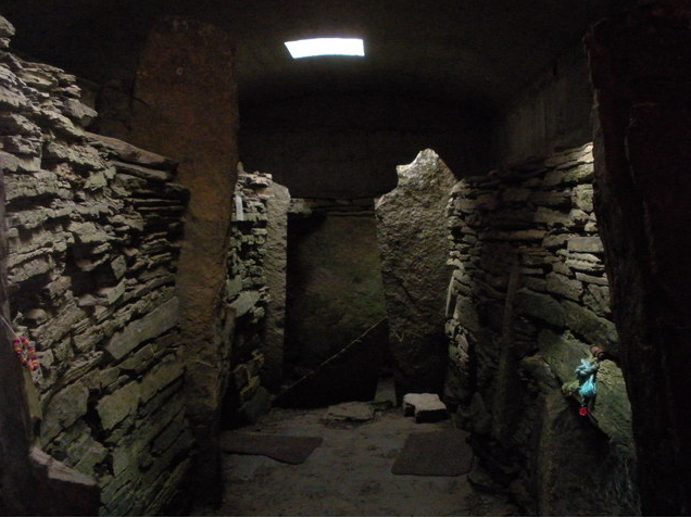
The passage that visitors use is 70 centimetres wide and 85 centimetres high. The scheduling description calls the passage very low and the interior an elongated rectangle, divided by upright slabs into five stalls, with three ancillary chambers opening off the main one. The stalled ends are the Orkney–Cromarty part of the design. The corbelled cells, set in the thickness of the wall opposite the entrance and in the wall to the right of it, are the Maeshowe-type part.
Shelves once stood in the stalled compartments, as they did at Midhowe. A horn of curving stonework leaves the north side of the cairn, a feature shared with tombs on Rousay. An early trench found the northern part of a stalled chamber of at least four compartments. The north compartment was fully cleared: 3 feet 8 inches long, 5 feet 9 inches wide, and 4 feet 8 inches high.
The next was 6 feet 3 inches by 4 feet 6 inches, with side walls 5 feet 2 inches high. The third was about 7 feet 3 inches long. A side cell off the west wall of the second compartment was roughly 4 feet 6 inches square and about 3 feet high, and it had not been filled. Two wall faces of horizontal slabs, still 3 feet 3 inches high, ran across the north end of the cairn.
Forty-two feet north-north-east of the chamber, a small orthostat and a short stretch of wall were exposed.
The 1987 excavation, made so that a roof could be built, showed how the mound was stacked. West of the chamber the cairn was repeated layers of flat overlapping flagstone, with larger stones on the faces. East of the chamber, and on either side of the entrance, the build differed because of the cell north of the passage. South of the passage, the foundations of an intervening wall continued across the entrance as a lintel and then disappeared into rebuilt masonry.
An encircling wall about 2 metres wide enlarged the central cairn, and ties joining the two walls were found in crumbling masonry west of the chamber. Extra walls, two south of the entrance and one north, oversailed the second cairn wall from ground level. An outer wall with a basal plinth, already noted at the north end, completed the first design and narrowed toward the ends of the cairn. At the front, six walls could be traced on the south and at least four on the north.
The passage was lengthened, and the masonry to either side may have been stepped, drawing the eye in and down to the door. Coastal erosion, later stone robbing and weather had blurred that facade. The wide approach and the elaborated entrance were still readable.
The tomb was a place for the dead of a community, and perhaps for only some of them. Sixteen thousand human bones, or pieces of bone, were recovered. No intact skeleton was recognised in the first reading of the mass, though a photograph later showed a cranium, a vertebral column and possibly the hip bones of one person still in anatomical order, so at least one body seems to have come in whole. The bones lay all over the floor, mostly along the walls, and each skull seemed to have a pile of bones with it.
Skulls lined the main chamber. The two cells at the west end held dozens more, with other human bone. The remains looked sorted after an earlier mixing.
The number of people has been counted in several ways, and the figures do not agree. An early opening produced skulls of thirty individuals. The 1983 study by the surgeon Judson T. Chesterman, who had also examined the dead from Quanterness, gave a minimum of 342 people, and John Hedges wrote that the conditions meant the true number must have been higher.
A scheduling account says at least 338 individuals, and probably more. Another count is at least 324. A heritage account of the recent community purchase says as many as 341, and calls that the largest number of Neolithic burials from Orkney or from any megalithic tomb in the United Kingdom and Ireland. David Lawrence, also called Dave Lawrence, re-examined the assemblage.
In 2006, and in a larger study completed in 2012, he concluded that the material represented 85 individuals, not 342. He warned that the published minimum was greatly inflated and that the older figures should be used with caution until more work was done. Even 85 is still one of the largest Neolithic groups from a single site in Orkney. The chamber had been dug into before the modern excavation, and the clearing of the fill took the deposits on the end-compartment shelves and probably whatever lay in the north-eastern side cell.
Had those survived, the count would have been higher. Colin Richards had already grouped Isbister with Quanterness as holding far more people than any other stalled cairn.
All ages were present, but infants were rare, which led Lawrence to suggest that infants were disposed of in some other way. Males were about twice as numerous as females. Isotope readings suggested that women had a greater share of marine food. The bones show hard physical work in both adults and children, accidental fractures, and disease, with arthritis and scurvy common.
One assessment said these people lived energetic lives and met many of the injuries and diseases known later. Another reading of 85 skulls found that at least 20 percent carried violent injury, possibly from wooden clubs and stone axes. Lawrence described the cranial fractures in more detail: circular blunt-force marks consistent with a mace or a sling stone, linear and oval marks consistent with clubs, hafts or rocks, narrow penetrating wounds consistent with a pointed weapon or an antler pick, and sharp-force marks consistent with a glancing axe. On two crania the lesions indicate close contact rather than a missile, and another person seems to have been finished with a cluster of blows after being stunned, the wounds matching a single blunt weapon of circular section.
A stone fragment embedded in a piece of juvenile skull was read as part of a broken weapon, perhaps shaped, perhaps simply a stone to hand. Possible violence has also been noted at Quoyness and Quanterness, and head trauma on some skulls at Cuween. That picture sits far from an older idea of a peaceful and equal Neolithic in Orkney.
Mark Edmonds asked whether Isbister was typical of the people living nearby, or whether some were chosen for the tomb because of their condition. Craniosynostosis, which changes the way a skull grows, is far more common in the group than would be predicted. He left open whether people who had suffered what he called bad deaths were feared, or were thought to hold special power. Kinship may have governed entry to many tombs.
At others the tomb advertised the standing of a group. Isbister may have been a case where the dead were powerful in another way. The stone-tool study of the site makes the same point: some tombs may have held, for a time, people whose deaths or whose bodies were thought dangerous.
How the flesh left the bone is disputed. Perceived weathering was once taken as proof that bodies were excarnated outside the cairn and only then brought in. The shortage of small bones at Quanterness, dug in 1972–74, had already been explained that way, and Isbister seemed to confirm it. John Hedges conjectured that the dead were laid on platforms in the large natural bowl of flagstone outside the entrance.
An account of the island still says the bodies were exposed to the elements before burial. The sea eagles were folded into that story. They were called a totem, and they were imagined stripping the corpses. Radiocarbon dates have since shown that the eagle bone entered the chamber up to a thousand years later, so the birds did not deflesh the first dead.
A re-examination of Quanterness argued that complete, fleshed bodies were placed inside and left to decay, sometimes hurried by deliberate dismemberment, and that the missing bones had either perished or been overlooked. The estimate there fell from 157 people in the 1970s to 59. Lawrence found little colour-fading, low weathering scores and no root erosion at Isbister, and he took that as evidence against any real excarnation outside the tomb before burial. He allowed that bodies might have been left in the open, but only if that process destroyed bone rather than producing a collection for later burial.
The articulated individual in the photograph points the same way. Bones were probably deposited complete, left to rot, and then disturbed and trampled as later burials or other events took place. Skulls were afterwards set along the walls or piled in the side cells, as at Midhowe and the Knowe of Yarso. Some bone may have been brought from elsewhere.
A 2024 study of the Knowe of Rowiegar on Rousay, a different cairn, found people placed at different stages of decay: some soon after death, some perhaps buried elsewhere and then moved, and no evidence there for excarnation. The eagle story has nonetheless stayed in the popular telling.
The animals were not only eagles. Cattle, sheep, otter and red deer were found through the tomb, with birds and fish. Cow bones were numerous with the hornwork outside. Sheep bones, read as joints of lamb, were found only inside, which has been taken as a hint of feasting in and around the cairn.
The bird bones numbered 725. Don Bramwell identified 641 of them as white-tailed sea eagle, Haliaeetus albicilla, at least eight birds. Hedges thought there might have been more than twenty. A scheduling account says at least five carcasses.
The public summary of the tomb says talons and bones from eight to twenty birds. Some of the eagle bone was described as a foundation deposit made when the tomb was built, and some lay with the human bone and in later fill. That was the basis for calling the eagle a totem of the people buried there, and for linking Isbister to animal deposits at Cuween and the Knowe of Yarso.
Two radiocarbon dates undid the foundation story. They were obtained by Finbar McCormick, of Queen’s University Belfast, with Alison Sheridan, then of the National Museums of Scotland, in a study of animals from Scottish chamber tombs. The samples were prepared in Belfast and measured in Oxford, and they were corrected for a marine diet. The eagles died about 2450 to 2050 BC, up to a thousand years after the tomb was built.
There was no age difference between a bone from the so-called foundation deposit and a bone from above the floor. The birds were deliberately buried. The dates are part of a wider finding that the Neolithic tombs of Orkney stayed open, to people and to animals, for many generations. The main period of deposition at Isbister has been placed between 3200 and 3000 BC, with the place still special well into the third millennium.
Human bone from inside the chamber has given Neolithic dates between about 3400 and 2800 BC. A pair of burials outside has given Bronze Age dates of about 2500 to 2300 BC. Other accounts of the same tomb say it was built about 3250 BC and used until about 3000 BC, or about 3200 BC, or that it was in use for 800 years or more from 3150 BC. A timeline of the same islands marks the building at about 3000 BC.
One assessment says construction may have taken a full century, that the tomb was used regularly for 800 years, and that the last burial was around 1600 BC. An account of South Ronaldsay says continuous use for a millennium or more. The absence of Grooved ware inside the cairn has been read as a sign that the burials came before that pottery was widely adopted, around 3200 BC, unless, as at Tofts Ness on Sanday, the pottery was simply not used. At the end of its Neolithic life the cairn appears to have been deliberately filled, sealing the contents and closing the passage, a closing known at other Orcadian chambered cairns.
The white-tailed eagle, also called the sea eagle, is a large bird of prey of coasts, lakes, wetlands and rivers. It nests on cliffs or in old trees and lives mainly on fish and water birds, and it will scavenge. It is the largest eagle in Europe across most of its range. Length runs from 66 to 94 centimetres, and a typical wingspan is 1.78 to 2.45 metres.
It may have the largest wingspan of any living eagle. In one Norwegian sample, five males averaged 2.26 metres across the wings and eight females 2.37 metres. A Greenland bird reached 2.53 metres, and another has been given as 2.6 metres. Weights of birds reintroduced to Scotland from Norwegian stock averaged 4.98 kilograms for 39 males and 6.06 kilograms for 43 females.
The largest talon, the hallux claw, is 37 to 46 millimetres, averaging 40.9. Studies of prey remains have put about 48.5 percent of the diet as birds, about 40 percent as fish, and about 10 percent as mammals. Captive birds were estimated to need 500 to 600 grams of food a day. The species breeds from Greenland and Iceland eastward across Eurasia, and it has been put back into Ireland and Scotland, and into England in 2019, after a long absence.
Persecution ran from the early nineteenth century until about the Second World War, and poisons followed. Carl Linnaeus named it in 1758, as Falco albicilla. The genus name Haliaeetus, given in 1809, means sea eagle. An Anglo-Saxon name is erne, a soarer, and one Gaelic name is iolar sùil na grèine, the eagle of the sun’s eye.
The bones in the cairn belong to this species. They do not, on the present dates, belong to the generation that built the tomb.
The Orkney vole, a form of the common vole found only on these islands, was brought in during the Neolithic. It is larger than the common vole, with shorter and paler fur than a field vole. The oldest radiocarbon-dated fossil is 4,600 years before present, which is the latest the introduction can have happened. That animal is part of the same farming age as the cairn, not a find from inside it.
On Hoy, the Dwarfie Stane is a tomb cut into a single huge block of red sandstone, with a hollowed chamber. It is unlike any other Neolithic site in Orkney and is placed around 2500 BC. It was the first Orcadian ancient monument described in writing, in the sixteenth-century Descriptio Insularum Orchadiarum of Joannem Ben, who said giants had made it and used it. It is not Isbister.
In September 2021 two polished stone balls were announced from a Neolithic burial tomb on Sanday, about 5,500 years old. One was described by Hugo Anderson as the size of a cricket ball, perfectly spherical and beautifully finished. Those balls were not found at Isbister.
The Bronze Age thins the monumental record, but it does not empty the islands. On the Mainland there are Knowes of Trotty, Kirbuster Hill, and the Plumcake Mound near the Ring of Brodgar. Elsewhere there are Tofts Ness on Sanday, Warness on Eday, two houses on Holm of Faray, and a burnt mound and farmstead on Auskerry. Liddle, beside Isbister, is the burnt mound that belongs with this visit, not those others.
From about 1000 BC a Celtic culture is reckoned in Scotland, though the character of any Orcadian Celtic society, and its relations with its neighbours, is largely unknown. The great ceremonial circles on the Mainland went on being used while bronze-working arrived slowly. South Ronaldsay’s own later life is a different story from the cairn: in 1627 nine chapels were listed on the island, several of the names hinting at Christian worship before the Norse earls, and a late seventeenth-century description called the island fertile in corn and full of people. None of that rewrites the stalls under the turf at Isbister.
The objects are as mixed in date of discovery as the bones. When Ronald Simison first worked in the tomb he found a macehead, polished stone axes and a V-perforated button. The button has been called albertite in one account and a V-bored jet button in another, and both descriptions are in print. The early finds, listed with the National Museum of Antiquities of Scotland, also included a polished stone knife, a cylindrical bone bead and four pottery sherds, one of them probably from a carinated bowl.
Later digging produced large quantities of Unstan bowl pottery, beads of jet, shell, bone and antler, an ard point, and flaked and cobble tools. The flint was mostly flakes, some of them scorched, and the tools were mostly scrapers. A pestle macehead came from a cache outside the tomb. More than 25 kilograms of pottery sherds were recovered.
Most of the collection is in the Tankerness House Museum in Kirkwall. A small, largely unstratified group from 1987, of bird, fish, animal and human bone, pottery and shell, went there as well, with an archive report. The 1987 archive of the building work is with the National Monuments Record in Edinburgh.
Ronald Simison, also called Ronnie Simison, was the farmer on whose land the slabs stuck out of an eroded mound. In 1958 he was digging flagstones when he found the tomb. He conducted a limited excavation, took out some bones and skulls, and filled the site with earth again. Mike Pitts later pictured him meeting human skulls by the light of a cigarette lighter.
One record of that first season attributes the partial excavation to P. R. Ritchie, whose account of a chambered cairn at Isbister appeared in the proceedings for 1958–59, a volume also cited under the year 1961. The description of the filled-in trenches was taken from that account.
Simison, frustrated that professional archaeologists did not take the site further, returned in 1976 and carried out his own larger dig. An enormous amount of material was removed. John Hedges, alerted by Simison, made the full study, published the technical account Isbister: a chambered tomb in Orkney in 1983, and wrote the book that fixed the popular name. That book is cited as Tomb of the Eagles: A Window on Stone Age Tribal Britain, in 1984, and as Tomb of the Eagles: Death and Life in a Stone Age Tribe, in 1990.
A review called the work reasonably well done, and asked how much better it might have been. Hedges also wrote a guide to the Isbister cairn and the Liddle burnt mound. Simison worked again in 1980–82 behind the north hornwork and west of the tomb, where a retaining wall was found. An Ordnance Survey visit on 25 April 1973 found the east half of the cairn eroded away and four slabs of the stalled chamber exposed.
In 1972 Simison found the burnt mound at Liddle, nearby. It is described as the best example in Orkney of a Bronze Age cooking place. Flat slabs, originally sealed with clay, formed a central trough that would have been filled with water and heated by stones, with peat as the fuel. The building was probably roofless.
The mound lies on the walk between the later visitor centre and the cairn, and it is the Bronze Age site shown with the tomb. The Bronze Age in Scotland is placed from about 2200 BC to about 800 BC, and Orkney has fewer large stone monuments from it than from the Neolithic. Burials moved into small cists, away from the great tombs, and a Beaker culture took hold. Ancient DNA from 22 Bronze Age people on Westray found about 93 to 96 percent of their ancestry related to Scottish Bell Beaker groups, and only about 4 to 7 percent associated with Neolithic Orkney, though some indigenous male lineages lasted at least another thousand years.
The pair of later burials outside Isbister belongs to that Bronze Age return. Deteriorating weather in the second millennium BC has been offered as one reason the monumental record thins. The great circles on the Mainland nonetheless stayed in use, and bronze-working arrived slowly from Europe.
The cairn was scheduled in 1961. One record gives 19 September 1961 and another 20 September 1961. The entry was amended in 1995, on 9 October in one record and on 10 October in another. The ground then in the care of Orkney Islands Council is a five-sided fenced plot: the east side about 41 metres, the south 26 metres, the south-west 38 metres, the north-west 25 metres and the north-east 20 metres, taking in the cairn, the surrounding wall and platform, and the spur wall.
In 1987 the tomb was received into guardianship by Orkney Islands Council, whose aim was to cover it, make it safe and show it to the public. The work was paid for jointly by the council and the Historic Buildings and Monuments Directorate. Part of the masonry was excavated for the foundations of a concrete roof over the central chamber. The walls on either side of the entrance were built up to meet that roof.
Earth and grass were laid over it so the mound would match the ground around it. A course of slate marks new masonry from old. Intact floors in the chamber and the side cells were left. A reconstructed funeral deposit was placed in one cell so that visitors could see one version of an Orcadian Neolithic burial.
The roof of the interior, as visitors meet it now, is 3 metres high, with skylights. The infobox height of the monument is given as 2.75 metres.
The site was run for years by the Simison family. Ronnie and Morgan Simison’s daughters, named as Freda Norquay and Kathleen MacLean, operated it until the pandemic. A photograph of the later reopening also names Kathleen MacLeod among the previous owners. During the COVID-19 pandemic the tomb closed to the public.
The closure has been tied to the retirement of the owners, and also to staffing problems and health concerns that prolonged it. In May 2021 the future of the place was publicly in doubt. The family supported a plan for the community to buy it rather than see it sold on the open market.
In April 2025 the South Ronaldsay and Burray Development Trust received £357,705 from the Scottish Land Fund toward the purchase of the visitor centre and the wider holding. Steve Sankey, chair of the trust’s Tomb of the Eagles development group, called the award innovative and said he believed it was the first time a Scottish community had tried to acquire an ancient monument in guardianship. The Simison family said the goal of community ownership was a fitting legacy for Ronnie and Morgan, who had given a great part of their lives to the site. The sale was to include the cairn, the Liddle burnt mound, the visitor centre, an uninhabitable house, twelve agricultural buildings, and land with access strips along the coast.
The trust’s aim was employment, volunteering and a ten-year development of the asset. In June 2025 a further heritage lottery grant of £101,607 closed the remaining gap, paid for staffing in the first full season, and was to help build an accessible replica tomb beside the visitor centre so that a visitor using a wheelchair could meet something of the atmosphere of the original. Ruth Owen, chair of the trust, called it the last piece of the funding. The trust also planned a community archaeology programme with the Archaeology Institute of the University of the Highlands and Islands, and new research on the site.
A 2026 account of the reopening spoke of over £1 million in funding, a larger sum than the two awards named above, and called the cairn the first scheduled monument to come into community ownership.
A laser scan and photogrammetric survey in 2024, by Kai Wallace and Graeme Cavers, recorded the interior and the exterior for the trust, to guide conservation. A scanner and a drone produced a three-dimensional model, with elevation images, plans, cross sections, and axonometric and cutaway views, plus notes on condition. It was a record of the standing structure, not a new excavation of the floor.
The tomb, the Bronze Age mound and the visitor centre had a grand reopening on a Sunday at the end of May 2026, in the trust’s first full season. One account of that day said the tomb had been uncovered fifty years earlier by Ronnie Simison, a date that points to the 1976 excavation rather than to 1958. Steve Sankey said a replica would be built on the ground of large byres near the visitor centre, which would be taken down, and that he knew of no other tomb in Scotland with a one-to-one replica. The replica was meant to protect the real cairn and to add to the visit.
The Simison farmhouse, where Ronnie and Morgan and their daughters had served tea and shown skulls, was to be renovated. Freda Norquay, for the Simison Partnership, said they were glad the tomb would continue under the new management. Pentland Ferries became the principal sponsor. In January 2017 the cairn had been featured on BBC Two, in the archaeology series Britain’s Ancient Capital: Secrets of Orkney.
The official visit, as stated for the site itself, is closed for the winter, with reopening at Easter 2027. When it is open, the day runs from 10am to 5pm, first admission at 10am and last admission at 3.30pm. The 2026 prices are £10 for an adult, £8 for a visitor of 65 or over and for a disabled visitor, £6 for a child from 7 to 15, and nothing for a child under 7 or for a carer. Orkney residents are charged a fifth less.
A family ticket for one adult and two or more children of 7 or over is £18, and one for two adults and any number of such children is £25. A tour guide with a party of five or more is free, and those visitors pay £8. A guidebook is £5. Large coaches are not allowed.
A person who feels unwell, or who is claustrophobic, is advised not to enter. The way in is to crawl the three-metre passage or to lie on a trolley. The passage roof is low at both ends, and a visitor is told to take care not to strike their head. Dogs on leads are welcome.
Pushchairs are admitted except in extreme wet weather, and wheelchairs are possible in dry conditions. The hands-on display in the centre includes original objects from the sites.
Other megaliths of a broadly similar age stand far from this cliff, and none of them is part of the Isbister cairn. The Almendres Cromlech, west-south-west of Nossa Senhora de Guadalupe in the municipality of Évora, in the Alentejo, is a group of cromlechs and menhirs, the largest structured group of menhirs in the Iberian Peninsula. Henrique Leonor Pina rediscovered it in 1966. Its building has been phased at about 6000 BC, 5000 BC and 4000 BC, from the early to the late Neolithic, and on into the Chalcolithic.
About ninety-five granite monoliths stand in circles and ellipses. It has been read as a ceremonial place or as an early observatory. It has nothing to do with the dead of South Ronaldsay. Auld Bourtreebush is a large Neolithic stone circle near Portlethen in Aberdeenshire, also called Old Bourtree Bush.
It is about 25 metres across and is thought to have had up to fifteen orthostats, of which four still stand. A ring cairn inside it has been destroyed. It was once taken for a recumbent circle, a view that has been rejected. It lies near the Aquhorthies recumbent circle and near the Causey Mounth, the old high road from the Dee toward Stonehaven.
In 1639 William Keith, 7th Earl Marischal, and the Marquess of Montrose led a Covenanter army of 9,000 along that road. That war is fifteen centuries and more after the last use of Isbister. Barbrook One is an embanked stone circle on Ramsley Moor in the Peak District. One stone is a metre high and eleven others are between 5 and 25 centimetres.
The interior is about 13 metres across, inside a rubble bank 3 metres wide. About eighty cairns lie on the moor, many of them small clearance heaps, some of the larger ones likely Bronze Age graves. A local tradition says that William Hale used the circles while converting people to Christianity. Bedd Arthur, Arthur’s Grave, is a possibly Neolithic oval of thirteen low uprights and at least two fallen stones in the Preseli Hills of Pembrokeshire, about 20 by 10 metres, with a faint bank and ditch.
The stones lean inward, as if they once flanked a mound. It has not been excavated. It looks over Carn Menyn, a rock that has been proposed as a source for some Stonehenge bluestones, a link that remains unproved. The name is one of many Arthur place-names in the district, folklore rather than a burial record.
Beglik Tash is a prehistoric rock sanctuary on the Black Sea coast of Bulgaria, a few kilometres north of Primorsko, reused by Thracians in the Iron Age. Karel Škorpil wrote the first scientific account, when it was known as Apostol Tash. Excavation from 2002 was led by Tsonia Drazheva. Ceramics of the tenth to sixth centuries BC, of classical antiquity and of the Middle Ages have been found, with a stone altar in a cave that takes a noon shaft of sunlight.
It is an open-air museum. Brennanstown Portal Tomb, also called the Glendruid Dolmen or the Cabinteely Dolmen, is a portal tomb in County Dublin, a national monument on the north bank of the Carrickmines River, about 1.2 kilometres south of Cabinteely. BBC Two, the channel that showed the Orkney series in 2017, is the second flagship television service of the public broadcaster, split off in 1964 with a remit for programmes of depth and substance. These places and that channel explain nothing of the stalls at Isbister except that stone monuments of the Neolithic world are widespread, and that this particular cairn has a modern public life.
What the cliff tomb changed, on the evidence, is the sample of a Neolithic community in the south of Orkney: a hybrid stalled cairn and passage grave, used and reused from the later fourth millennium into the third, filled and closed, remembered by eagle bone put in centuries afterward, cut by the sea, found by a farmer, roofed for visitors, and at last bought by the island community that lives beside it.
Sources
- Isbister — Working Stone
- Tomb of the Eagles — Wikipedia
- Isbister, chambered cairn 450m ESE of — Historic Environment Scotland
- Visitor information — Tomb of the Eagles
- Tomb of the Eagles — Tomb of the Eagles
- Isbister cairn, the human remains — Ness of Brodgar Project
- Flight of the eagles — British Archaeology
- Bringing a 5,000-year-old Orkney tomb back to life — National Lottery Heritage Fund
- Delight as Tomb of Eagles Awarded Funding — The Orkney News
- Tomb of the Eagles replica planned by new owners — The Orcadian
- Isbister, an Orkney Islands Council Guardianship Monument — Society of Antiquaries of Scotland
- Isbister: Tomb of the Eagles archaeological condition survey — Archaeology Data Service
- Prehistoric Orkney — Wikipedia
- South Ronaldsay — Wikipedia
- White-tailed eagle — Wikipedia
- Tomb of the Eagles.jpg — Wikimedia Commons
- The Tomb of the Eagles, Orkney - geograph.org.uk - 27983.jpg — Wikimedia Commons
- Entering the Tomb of the Eagles - geograph.org.uk - 882940.jpg — Wikimedia Commons
- Inside the Tomb of the Eagles - geograph.org.uk - 882949.jpg — Wikimedia Commons
- The Tomb of the Eagles - geograph.org.uk - 1452411.jpg — Wikimedia Commons
- Isbister Chambered Cairn 20110524.jpg — Wikimedia Commons
- Isbister Chambered Cairn 20110524 looking north.jpg — Wikimedia Commons
- Isbister Chambered Cairn 20110524 looking south.jpg — Wikimedia Commons
- Tomb of the Eagles 1.JPG — Wikimedia Commons
- Tomb of the Eagles 2.JPG — Wikimedia Commons