

Somerset, United Kingdom · Neolithic · 3808 BCE · United Kingdom
- A Neolithic timber walkway on Shapwick Heath, crossing the reed swamp between Westhay and the Polden ridge in 3807 or 3806 BC.
- The Post Track on the same line dates from around 3838 BC, and some of its planks were built into the later walkway.
- Oak planks on crossed pegs formed a single-file path, repaired until 3800 BC and then abandoned after at least six years, or about ten.
- Ray Sweet found the timbers while cutting peat, and John Coles and Bryony Coles excavated the route from 1970 into the 1990s.
- An unused jadeite axe from the Alps was left beside the Railway site, and milk fats in nearby pottery are the earliest dairying evidence cited for the United Kingdom.
Visiting
Entry is free and the site is open seven days a week.
History
The Sweet Track is a raised timber walkway on Shapwick Heath in the Somerset Levels, built across reed swamp between an island at Westhay and the Polden ridge. Tree rings place the work in 3807 BC, in 3806 BC, in 3807 or 3806 BC, over the winter of 3807 to 3806 BC, and, in one account, in the spring of 3806 BC. The distance is given as about 1,800 metres, as 1.8 kilometres of traced timber, and as about 2 kilometres.
The Post Track already followed that line around 3838 BC, thirty or thirty-two years earlier, and some of its planks were reused. Crossed pegs held oak planks in a single-file path about 20 to 30 centimetres wide, raised about 40 centimetres above the rails. Repairs run down to 3800 BC and are described as lasting at least six years, about ten years, or at least ten, before the walkway was abandoned, perhaps under rising water.
Neolithic farmers used the valley for grazing, fishing, and timber, and pottery beside the track contained fats from cow's milk, called the earliest dairying evidence in the United Kingdom. An unused jadeite axe from the Alps was left at the Railway site in 1973, although the peat around it dates to about 3200 BC. Older oaks from a northern wood and younger oaks from a southern wood may mark two communities at work on the same route.
Ray Sweet, a peat cutter, found the timbers while ditching behind the peat factory. The find is placed in 1970, in the early 1970s, and in 1973. John Coles and Bryony Coles directed the Somerset Levels Project from 1973 to 1989 and opened the Factory, Burtle, Railway, Drove, and South Drain lengths, then a possible southern end in 1993.
Most of the wood was left in the peat. Pumps protect about 500 metres, and the reserve's water table wets the rest. In September 2016 trenches near Shapwick Burtle showed a slighter structure in the wet woodland and cut wood 40 centimetres above the track, used 500 to 700 years after the walkway ended. Through the dry summer of 2018 the burial stayed airless, and the reserve length was judged not currently at risk from drying.
Images




Detailed History
The Sweet Track is an early Neolithic timber walkway on Shapwick Heath, in the Brue valley of the Somerset Levels. It crosses the parishes of Shapwick and Meare. In the early fourth millennium BC it joined an island at Westhay to a ridge of high ground at Shapwick, close to the River Brue, and it is also described as running from Westhay island to the Polden Hill slopes, and from the island of Westhay to the dry land of the Polden ridge. One account gives the distance as close to 1,800 metres, or about 5,900 feet, or around 1.1 miles.
Another gives 2 kilometres, another almost 2 kilometres, another just under 2 kilometres, and another simply two kilometres of reed swamp. The traced length is given as 1.8 kilometres, with considerable variation in the condition of the wood along that line, and a survey in 1980 followed the line for about 1.5 kilometres. A shorter account of the same structure says it ran for over a kilometre and names the northern end Westhay Mears. The line is described as remarkably straight.
The walkway belongs to the Neolithic of the British Isles, the last stage of the Stone Age in these islands. The Stone Age is the long span in which stone was shaped into tools with an edge, a point, or a striking face. It lasted roughly 3.4 million years and ended somewhere between 4000 BC and 2000 BC, when metalworking took over. It covers more than 99 percent of human history.
A little gold and copper was already worked for ornament before that end, but the melting and smelting of copper is what closes the Stone Age. In western Asia that change had come by about 3000 BC, when bronze became widespread. The Stone Age is the first part of the three-age scheme, followed by the Bronze Age and the Iron Age, and it is itself divided into the Palaeolithic, the Mesolithic, and the Neolithic. Neolithic people were the first, in that scheme, to leave hunting and gathering for towns, villages, and farming, and the Neolithic overlaps the Chalcolithic, the copper age, before the Bronze Age.
The oldest indirect trace of stone tools is cut marks on animal bone 3.4 million years old from the Lower Awash Valley in Ethiopia. The Neolithic British Isles are dated from about 4100 BC to about 2500 BC. John Lubbock coined the word Neolithic in 1865 for the last part of the Stone Age, when people used polished stone and had not yet made metal tools. Later the word was widened to cover settled villages, cereal farming, stock keeping, and pottery, and then narrowed again by some archaeologists to the agricultural way of living.
Farming itself is far older than the Somerset walkway, and it did not begin in Britain. Aşıklı Höyük is a settlement mound nearly 1 kilometre south of the village of Kızılkaya, on the bank of the Melendiz brook, and 25 kilometres southeast of Aksaray in Turkey. It stands in the volcanic tuff of Cappadocia, at 1,119.5 metres above the sea, a little above the regional average of about 1,000 metres. The mound covers about 4 hectares, much smaller than the nearby site of Çatalhöyük at 13 hectares.
It was first settled in the Pre-Pottery Neolithic, around 8200 BC, and the newest dates put the occupation from 8200 to 7400 BC, in three layers and thirteen phases. That is thousands of years before any timber was felled for the Sweet Track. Ian A. Todd visited the mound in the summer of 1964 and stressed the obsidian: more than 6,000 pieces came from the surface alone.
The river had already cut part of the mound away. Unstratified radiocarbon dates ran from 7008 plus or minus 130 to 6661 plus or minus 108. Ufuk Esin of the University of Istanbul began salvage digging in 1989 because a plan would have raised the waters of the nearby Mamasın Lake. Nine seasons to 2003 opened about 4,200 square metres.
After more than 400 rooms, the people buried inside the settlement still numbered no more than 70, all of them under house floors, in pits cut while the houses were in use. Men and women and every age appear. Some bodies lie crouched, some extended on the back, some on one side with the knees bent. The men include individuals who reached 55 to 57 years.
Most of the women died between 20 and 25, and their spines are deformed in a way that shows they carried heavy loads. That does not by itself prove a division of labour, though the shorter female lives have been read as a sign of harder physical work. Obsidian from the district reached as far as Cyprus and Iraq. Aşıklı Höyük is not part of the Somerset Levels, and nothing in its houses, burials, or obsidian trade is a piece of the Sweet Track.
It is the earlier world of settled farming against which the much later British Neolithic has to be set.
The Goseck Circle is a Neolithic enclosure at Goseck, in the Burgenlandkreis of Saxony-Anhalt, Germany, on farmland between Naumburg and Weißenfels, near where the Unstrut meets the Saale. It was built around 4900 BC and seems to have stayed in use until around 4700 BC, so it too is older than the Sweet Track by about a thousand years. A ditch about 75 metres across, measured from the outer edge and up to 1.8 metres deep, is paired with two rings of palisade. The soil from the ditch made an outer bank.
Entrances to the north, southwest, and southeast, and smaller gaps, have been aligned with sunrise and sunset at the winter solstice and with the summer solstice. The site is presented as a ritual or cult structure. Marketing has called it one of the oldest solar observatories, but the solstice alignments are the only astronomical pattern emphasised in the remains. Otto Braasch found the circle in 1991 on an aerial photograph, as crop marks in a dry season under wheat, already badly eroded.
François Bertemes and Peter Biehl began a major excavation in 2002 with the state archaeology service and the University of Halle-Wittenberg. Radiocarbon places construction near 4900 BC, while the pottery is stroke-ornamented ware of about 4700 BC, so the circle may have lasted two or three centuries. Excavators found what may have been ritual fires, animal and human bone, and a headless skeleton near the southeastern gate, readable either as a burial rite or as a human sacrifice. In 2004 a group from the University of California, Berkeley, joined the dig.
After the excavation the palisade was rebuilt with 1,675 oak poles, each 2.5 metres high, shaped with hand tools. The reconstructed circle opened to visitors on 21 December 2005, the winter solstice. No internal buildings were found. The Goseck Circle is not a Somerset track, and its ditch and posts are not the rails and planks of Shapwick Heath.
In the early Mesolithic, Britain was still joined to the continent by Doggerland. Bryony Coles later named that drowned land after Dogger Bank, a sandbank in the southern North Sea, and in 1998 she drew hypothetical maps of it. Her article of that year has been called essential to making Doggerland a serious subject. The submergence she studied belongs about 8,000 years ago, long before the Sweet Track.
Caroline Malone described the late Mesolithic British Isles as a technological backwater, still living by hunting and gathering when most of southern Europe had already taken up farming and settled life. Around 4000 BC, migrants from central Europe began to arrive with new ideas. A 2019 study found a mass migration into the British Isles about 4100 BC. Those farmers were closely related to Neolithic people in Iberia, and so to agriculturalists who had moved west from the Balkans along the Mediterranean.
Their arrival is said to have replaced almost all of the native Mesolithic hunter-gatherers, who did not return genetically in the centuries that followed. Other accounts leave the mechanism open. Mike Parker Pearson set out the possibilities: pioneers in small crossings, a long mix of contacts from Denmark to France, or hunter-gatherers who sailed to the continent and brought animals and plants back. He also noted that the earliest farming evidence in the islands comes from Ireland and probably the Isle of Man, not from southern Britain.
There is no single answer in the sources. Domestic animals and plants had to come by boat. Malone described the British Neolithic as about 2,000 years, little more than 80 to 100 generations, in which a forested country became farmland and settled communities. The language those first farmers spoke is not known.
The earliest languages in the islands that are securely identified belong to the Celtic branch of Indo-European, which is a later fact and not a name for the Sweet Track's builders.
Clearance of woodland is part of that change, and the sources do not agree how it sits beside the track. One account says the uplands around the Levels were heavily wooded until people began to clear them for a mainly pastoral economy with a little cultivation, and that the builders had been managing the surrounding woodland for at least 120 years. Another, from a modelled sequence of dates across the Levels, places the construction of the Sweet Track two to three centuries before the first forest clearance. Across Britain, elm declined widely between 4300 and 3250 BC, millions of trees vanishing from the record.
Some have blamed Neolithic farmers, collecting elm leaves for winter fodder or stripping bark by grazing cattle. Pearson also raised the elm bark beetle and Dutch elm disease, with evidence at West Heath Spa in Hampshire, and the further suggestion that farmers might have spread the beetles on purpose. Forests regrew within a few centuries in several cleared districts, and the Somerset Levels are named among the places where that regrowth happened. Notable early clearances are cited at Broome Heath in East Anglia, on the North Yorkshire Moors, and on Dartmoor, around 5000 BC, done with stone axes and also by ring-barking and burning.
From about 3500 to 3300 BC many cleared areas were abandoned to trees again, and farming communities gathered on the better soils: the Boyne, Orkney, eastern Scotland, Anglesey, the upper Thames, Wessex, Essex, Yorkshire, and the valleys of the Wash. The Sweet Track, in the early fourth millennium, stands before that later concentration. Neolithic houses in Britain were usually rectangular and wooden, so the buildings themselves have not survived. Their foundations are rare and mostly found near stone monuments.
The people of Neolithic Britain have also been described as living in patrilineal communities. That is a statement about the wider society, not a family tree recovered from the track.
Shapwick Heath is the ground the walkway crosses. It is a biological Site of Special Scientific Interest and a national nature reserve between Shapwick and Westhay, notified in 1967, of 394.0 hectares, or 973.6 acres. It is a former raised bog in the basin of the River Brue, part of the Avalon Marshes, and it is managed as a national nature reserve by Natural England. Since January 2009 it has also sat in the Brue Valley Living Landscape project, which set out to restore, recreate, and reconnect habitat so that wildlife could cope with climate change while farmers and other owners still used the land.
The heath holds a rich invertebrate fauna. National rarities there include the great silver diving beetle and the lesser silver diving beetle, the latter now confined in Britain to the Brue Basin peat moors. The adjoining Shapwick Moor was bought by the Hawk and Owl Trust. Ham Wall lies to the east.
One account of the heath calls the Sweet Track one of the oldest engineered roads known and the oldest timber trackway discovered in northern Europe. The early landscape of the marshes was not one uniform swamp. It shifted among open water, reed swamp, wet woodland, and raised bog. The track was built to cross common reed swamp that held pools, small streams, and patches of moss and cotton grass, with deciduous forest on the nearby dry land.
Near the southern end the ground changes. The route climbs toward a ridge of hard geology called Shapwick Burtle, and the structure becomes less massive as it leaves the reed swamp for wet woodland at the edge of that island. In the reed swamp the classic raised walkway survives. In the wet woodland it is slighter, less deeply buried, and in the 2016 trenches it showed more recent decay.
The builders are described as Neolithic farmers who had colonised the area around 3900 BC and who, by the time of the track, were organised and settled. Winter floods would have given fish and wildfowl. Summer opened grassland for cattle and sheep, and supplied reeds, wood, timber, animals, birds, fruit, and seeds. Reaching the islands was pressing enough to justify a communal effort, stockpiling timber and building when the water was lowest after a dry spell.
The work shows skilled woodmanship and some division of tasks. Fats, or lipids, extracted from pottery found beside the track came from cow's milk. That has been called the earliest evidence of dairy farming, or of dairying, in the United Kingdom. The people were not literate.
There is no written reason, in their own words, for the path. One reading treats it as a communication route that let people use the wetland. Another says the variety of objects along it shows daily use in a farming life. The quantity of timber and the care of the work have also been taken to mean that the community set particular store by keeping this line open.
A further suggestion is that the route had a spiritual side, and that is said of the earlier Post Track as well as of the later walkway. Offerings in shallow water, visible for a time before the peat closed over them, are part of that reading. John C. Barrett's warning about the wider period still applies: there was never one body of belief that can be called Neolithic religion, and the monuments do not express a single idea.
The Post Track is the immediate predecessor on the same line. It is an ancient causeway in the valley of the River Brue, dated to around 3838 BC, and it is some thirty years older than the Sweet Track. Another account says it was built in 3838 BC and may have lasted the 32 years until the Sweet Track was built. It has also been called the oldest trackway known from the United Kingdom, a title that other accounts give instead to the Sweet Track.
The Post Track was made of long ash planks, with lime and hazel posts at intervals of three metres. John Coles noted that its heavy planks were rarely pegged. Before the planks were dated, it was suggested that the Post Track had been a construction platform for the later walkway. Some of its planks were reused in the Sweet Track, which makes the dating more complicated.
It is thought to have been meant as a lasting route, repaired, maintained, and in time replaced as it failed. Several stretches of both tracks are scheduled monuments. The Sweet Track was predominantly built along the course of the Post Track.
The Sweet Track itself is dated by tree rings, and the published years do not all name the same season or the same single year. It is said to have been built in 3807 BC. It is also said to have been built in 3807 or 3806 BC. The felling and the first construction are placed in 3807/6 BC, and in the winter of 3807/3806 BC, and over the winter of 3807 to 3806 BC, and in the winter of 3807 BC, and in the spring of 3806 BC.
A public account of the reserve gives 3806 BC. A stored plank is assigned a production span from 3807 BC to 3800 BC. Most of the oak and ash along the route was felled in the same year, shown by the sapwood, which could mean the walkway was put up in a single year. Timbers felled from 3804 to 3800 BC are read as repairs.
Repairs are also said to run as late as 3800 BC, and the walkway was being repaired and maintained at least until 3800 BC. How long it then stayed in use is given in more than one way. One account says about ten years. Another says at least ten years, judged from hazel repairs.
Another says repairs for at least six years after the winter of 3807 to 3806 BC. Another says repairs for less than ten years, after which it seems to have been abandoned. Rising water may have engulfed it and ended its use. The hazel also indicates a coppice cycle of seven years.
An oak mean curve 410 years long has been cross-matched with an ash mean curve. Comparisons with wood from the River Trent and with a submerged forest at Stolford helped to map the rings and their relation to the climate of the time. At a possible southern terminal, twenty samples gave a chronology 237 years long, from 4651 to 4415 BC, and the close match suggests those samples came from one tree. The lack of a tree-ring link means that exposure cannot be proved to be the southern end of the Sweet Track.
It may be a different or earlier track on the same route. Green wood was used. Many pegs are warped and buckled. Sapwood was trimmed off, which has been taken as a high standard of wood technology.
The trees used at the Drove site were very different from those at the Railway site.
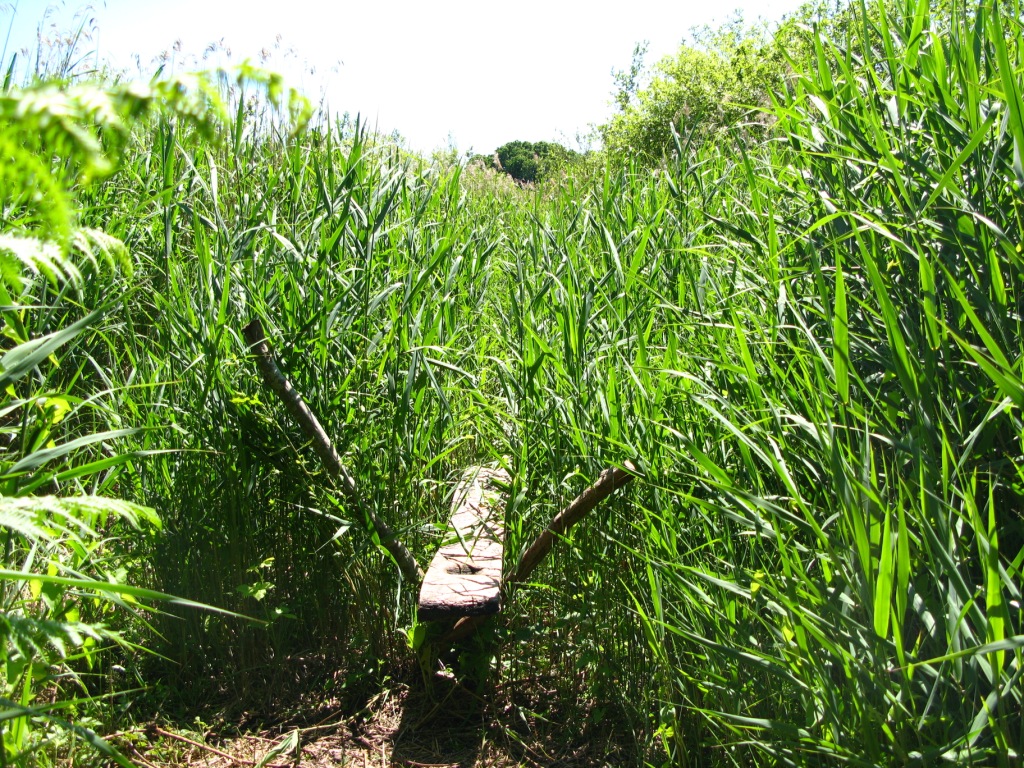
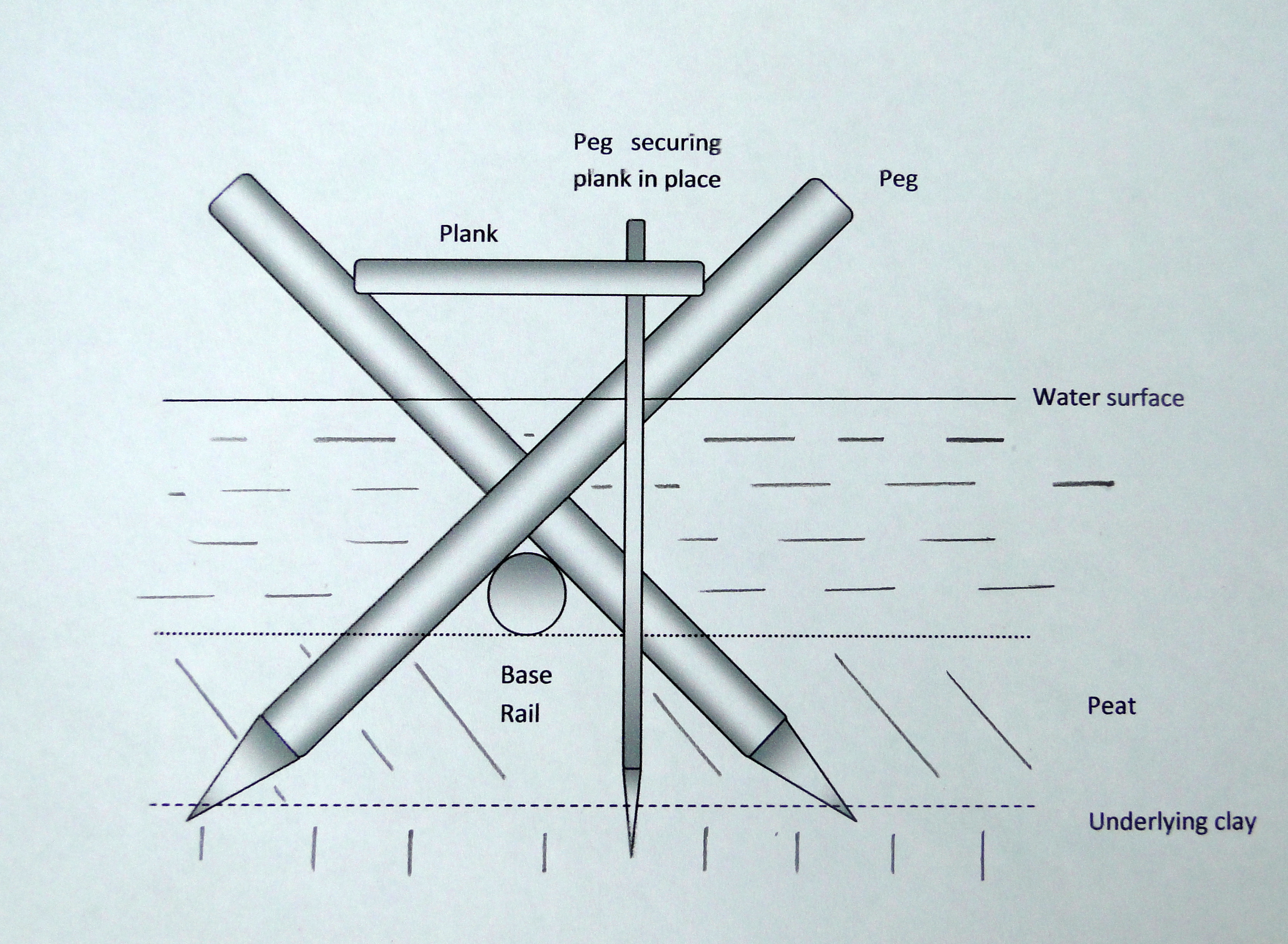
The structure is a raised plank walkway. Long rails were laid end to end on the marsh. Pairs or groups of pegs, about 1 metre apart, were driven obliquely into the peat on either side so that they crossed and made a V. Planks sat on those crossings, butted end to end, and the walking surface stood about 40 centimetres above the rails.
Notches on the underside of the planks fitted the pegs. Now and then a vertical peg was driven through a hole in a plank, or beside it. The planks are described as oak, and also as oak, ash, and lime, up to 40 centimetres wide, 3 metres long, and less than 5 centimetres thick, split from trees up to 400 years old and 1 metre in diameter. The southern end used smaller trees, and there the planks were split across the grain so as to take the full diameter of the trunk.
Longitudinal rails up to 6.1 metres long and 7.6 centimetres in diameter were mostly hazel and alder. Other accounts say the rails and pegs were mainly hazel and alder, and that bundles of apple, willow, alder, and birch were sometimes used as rails. The species list for the whole structure is oak, alder, elm, lime, hazel, ash, holly, willow, poplar, dogwood, ivy, birch, and apple. Oak was preferred for the walkway, and it was the dominant species for the planks, but the mix of species was not consistent even when the counts of pegs and rails were.
The pegs are ash, oak, and lime in one description, and their straightness and lack of branches suggest coppice. The parts were prepared on dry land and brought into the wet, though wood chips and chopped branches show that some trimming happened on the spot. Sharpened pegs went in slantwise. The planks were then wedged between the peg tops, parallel to the rails, and held by vertical pegs into the peat and sometimes the clay.
There were no saws and no steel axes. The tools were stone axes, wooden wedges, and mallets.
The walkway was narrow, suitable only for single file, and one set of measurements puts that width at 20 to 30 centimetres. In a few places a second rail was laid on the first to bring a plank up to the level of the rest. Transverse timbers under the rails steadied wet patches. At the Railway site, short vertical pegs were driven low and planks rested directly on them, and peat was packed between planks and rails.
That packing was not seen on the other excavated lengths, so it was not needed everywhere. No bindings were found. Double and triple rails, and transverse timbers, strengthened a particularly wet patch in an area of the Turbary site. In one 1995 trench a more complicated foundation had two layers of planks resting on three roundwood poles set at right angles to the line, again where the path crossed a wet place.
At the Burtle sand the level rises slightly. At one point an oak tree was used as a foundation. At another, a heap of felled timber made the track, and clay reinforced some stretches. The track was not seen in the dry sections there.
Rails, rail pegs, and vertical pegs off the main line may be a passing place, the start of a stretch that was abandoned, a relic of the Post Track, or discarded pieces. Planks lying beside the route may be Post Track planks never reused, stock left along the line and abandoned, or debris from planks that broke or shifted and were replaced.
The timber is estimated at about 200,000 kilograms, or 440,000 pounds. John Coles estimated that once the material was at the site, ten men could have assembled the walkway in one day. A reconstruction built in 1983 by John Coles and Bryony Orme, later Bryony Coles, showed a simple and effective construction that could be raised quickly, and that a level path depended on choosing pairs of pegs of the same size and setting them at the right angle. Heights above sea level vary along the route.
At the Factory site the planks lay between 1.55 and 1.65 metres OD, and the rails at about 1.53 metres OD. At the Drove site the rails lay between 1.15 and 1.45 metres OD and the planks between 1.3 and 1.57 metres OD. At the Railway site the rails lay between 1.45 and 1.6 metres OD. The upper surfaces of the planks were worn and decayed, which indicates extreme wetness.
Very few planks were found complete, and at the Railway site few were still in place. Many were rotten or collapsed.
The woodlands were not all the same. Large oaks, up to 400 years old, from a northern wood, were used from the northern terminal to the southern edge of the nature reserve. Immature oaks little over 100 years old, from a southern wood, were used for the southern 200 metres. That difference could imply two communities, a northern one and a southern one.
The height of the walkway let people pass while the marsh was flooded.
Finds along the timbers include a jadeitite, or jadeite, axe. It was found in 1973 at the Railway site, beside the track, and it is thought to have been placed there as an offering. The stone came from the Alpine area of Europe, and one account says from the French Alps. It had never been used.
Its condition and the difficulty of working the material are why axes of this kind in Britain are treated as symbolic, as a form of currency, or as gifts, rather than as tools for cutting wood. It is one of more than 100 similar axe heads from Britain and Ireland. Radiocarbon dating of the peat in which it lay suggests deposition around 3200 BC, centuries after the walkway's decade of repair. A different polished jadeite axe, from Breamore in Hampshire and dated about 3900 BC, has been traced by petrology to the Italian Alps.
That Hampshire axe is not the Railway site find, and the two provenances should not be folded into one object. Other objects from the Sweet Track include paddles, a dish, wooden bowls, arrow shafts, parts of four hazel bows, a throwing axe, yew pins, digging sticks, a mattock, a comb, toggles, a spoon fragment, and wooden stirrers. Flint flakes, arrowheads, and a chipped flint axe in mint condition were also found. Pottery was found beside the track, and some broken pots full of hazelnuts are cited among wetland finds that may be accidental losses rather than offerings.
A hoard of bronze axes near Edington Burtle belongs to the wider habit of placing metal in the marshes. It is not a Sweet Track assemblage. Studies of the excavated material examined flint microwear and organic residues, fossil insects and a second insect assemblage, bird pellets, plant remains, and the decay of the wood. The results that are stated, rather than merely titled, are these: fungus and bacteria were the main agents of decay; the timbers had already begun to rot before the peat covered them; and the track was not left exposed for long before that cover formed.
In the 1995 trenches, bacteria and ancient fungal hyphae were present, and all of the wood was highly decayed, with a moisture content of more than 400 percent.
The Sweet Track has been called the oldest trackway in the Somerset Levels and in Britain, the oldest wooden walkway in the United Kingdom, Britain's oldest trackway, and the oldest timber trackway discovered in northern Europe. It was also called the oldest roadway in the world until, in 2009, a trackway dated to 4100 BC was found at Plumstead, near Belmarsh prison. After that find the Sweet Track has been called the second-oldest timber trackway discovered in the British Isles. The Post Track, thirty or thirty-two years older on the same line, is called the oldest trackway known from the United Kingdom in the account that gives the Sweet Track a life of less than ten years.
These claims sit side by side in the sources. They are not one ranking.
The wood is bog wood. Buried in peat, kept from ordinary decay by acidic and airless conditions, it is stained brown by tannins and is an early stage of fossilisation. Bog wood of any origin can be hundreds of thousands of years old. The Sweet Track's own age is the Neolithic one given above, not that outer limit.
Most of the structure was left where it was built. The peat is why it lasted. Where the water table drops, the wood dries, and decay returns. That is the threat that has shaped every later decision about the monument.
Ray Sweet, a local peat cutter, found the track. The year is given as 1970, as 1973, and as the early 1970s. He was working behind the old peat factory on Shapwick Heath, and he is also said to have found it while cleaning a ditch, during peat excavation. The company he worked for is named E.
J. Godwin and E. J. Godwins.
In 1970 that firm sent part of a plank to John Coles, then an assistant lecturer in archaeology at Cambridge, who had already dug nearby trackways. The early date led to a large excavation in 1973, funded by the Department of the Environment. Geoffrey Wainwright, the local inspector, saw the digging continue in pouring rain, and central government support went on for many years, including after he became head of archaeology at English Heritage. The Somerset Levels Project ran from 1973 to 1989.
One account says it ran for 15 years until 1989. It was directed by John Coles and Bryony Coles, also named as Bryony Orme, later Coles. It was funded largely by the Department of the Environment and aided by the universities of Cambridge and Exeter, and it kept a full-time field archaeologist on the Levels. The project recorded some thirty or more groups of wooden trackways, and everyday objects, including what is believed to be a child's toy from the trackways as a group, not a named object of the Sweet Track alone.
Many tracks were named for the finder or for the peat firm or farmer: the Eclipse, Tinney's, Baker's, Garvin's, and Rowland's tracks. The Sweet Track took Ray Sweet's name. The project is credited with establishing the economic and geographic importance of trackways of the third and first millennia BC, and with techniques of wetland archaeology that are still used. From 1986 John Coles and Bryony Coles also coordinated an international network of wetland archaeologists.
In 1996, and in another account in 1998, their Levels work received the Imperial Chemical Industries award for the archaeological project that had made the greatest contribution to knowledge. In 2006 the work was recognised with the European Archaeological Heritage Prize.
John Coles (historian), whose full name was John Morton Coles, was born at Woodstock, Ontario, on 25 March 1930, and died at home on 14 October 2020. He graduated from the University of Toronto in 1952, worked in commerce for three years, began archaeology at Cambridge in 1955, and finished a doctorate at Edinburgh in 1957. He taught at Cambridge from 1960, was a fellow of Fitzwilliam College from 1963 until his death, and was Director of Studies to Prince Charles while the prince was at Trinity College. In 1979 he published The Bronze Age in Europe with A.
F. Harding, covering European prehistory from about 2000 to 700 BC. He became professor of European prehistory in 1980. He held a higher doctorate from Cambridge, was elected a Fellow of the Society of Antiquaries in 1963 and a Fellow of the British Academy in 1978, received an honorary doctorate from Uppsala, and was awarded the Grahame Clark Medal of the British Academy in 1995, the Gold Medal of the Society of Antiquaries in 2002, and the Gold Medal of the Royal Swedish Academy of Letters, History and Antiquities in 2009.
He had been active on the Levels from the 1960s.
Bryony Jean Coles was born on 12 August 1946. She studied history at Bristol, took a postgraduate diploma at the London Institute of Archaeology, and an MPhil in anthropology at University College London. In 1972 she became a lecturer in prehistoric archaeology at Exeter, was promoted to professor in 1996, and retired in 2008 as professor emeritus. She was elected a Fellow of the Society of Antiquaries on 27 November 1975 and a Fellow of the British Academy in 2007.
She married John Coles in 1985, and the marriage lasted until his death in 2020. In 1986 he left Cambridge and they moved to Devon. In 1998 they founded the John and Bryony Coles Bursary, to help students travelling abroad to study or work in prehistoric archaeology. Her later work on the European beaver began because distinctive marks on preserved wood from the Somerset Levels, at first taken for human cuts, were made by beavers.
She watched beavers in Brittany for about five years so that later excavations could tell beaver marks from human ones. That beaver study, and the Doggerland maps, are hers. They are not a second date for the Sweet Track.
The excavation of the walkway itself proceeded in named lengths. The Factory site, from 1970 to 1972, exposed 56 metres. The walkway there was almost level. Wood was chosen deliberately for particular parts and jobs.
A transverse timber sometimes lay under a rail, and more than one rail was sometimes used. Most planks were in poor condition. Further work returned to the Factory site in 1985. The Burtle site, in 1971 and 1972, exposed about 12 metres.
Radiocarbon dates agreed with the position of the track in the peat. The Railway site, from 1971 to 1975, exposed 131.5 metres, built like the stretches already seen, and produced the jadeite axe. Small slivers, slats, and chips lay among the timbers and in the peat. The Drove site, in 1977, exposed 50 metres, with little debris.
An emergency dig in 1979 at the South Drain was followed in 1980 by small excavations and borings that traced the line. Further digging in 1981 and 1982 confirmed that wetter ground received heavier foundations and drier ground a simpler build. In 1989 more exposures were recorded. In 1993 a possible southern terminal was examined.
Trench C was the most informative. The build there resembled an earlier excavation on Shapwick Burtle: a bog-oak trunk reused, and heavy timbers, which implies drier ground and a simpler structure, while wetter ground had more substantial foundations. An evaluation in 1995 read the track as a route for exploiting the wetland. Two trenches out of four had desiccation cracks.
Trench 3 was the worst preserved even though the water was high, which implies that the ground had been dry when that part was built.
Before the Sweet Track was known, other people had already worked the peat archaeology of the valley. Arthur Bulleid was sent finds by a farmer in 1895 and so found the Iron Age settlement at Meare. With Harold St George Gray he dug the eastern and western Meare lake villages between 1910 and 1956. He also recorded wooden trackways in the peat cuttings, and a paper of his in 1933 inspired much of the later work.
Harry Godwin, professor of botany at Cambridge, bored the peat between 1937 and 1965 and, with Stephen Dewar, excavated small finds and trackways. The first trackway to be discovered was the Abbot's Way, a corduroy of alder logs between Burtle and Westhay, found in 1873 and named for the Abbot of Glastonbury, who was thought to have ordered it because the abbey had owned the land in the Middle Ages. It was in fact built four and a half thousand years ago, more than 3,000 years before the first abbot was born. By 1996 the Abbot's Way, which had not received the same water management as the Sweet Track, was dewatered and desiccated.
Simpler tracks of brushwood, pegged by small stakes, were the commonest way of crossing the bog. In the later Bronze Age, between 1400 BC and 800 BC, the raised bog grew wetter, perhaps because the climate changed, and heavier tracks were built. The Meare Heath track, of large oak planks on brushwood and on transverse planks like sleepers, is the most impressive of those, and a replica of it stands on Shapwick Heath. It is not the Sweet Track.
The Honeygore, Abbot's Way, Bells, Bakers, Westhay, and Nidons trackways are other prehistoric routes on the peat, linking settlements. Mounds at Westhay mark prehistoric lake dwellings thought likely to resemble the Iron Age Glastonbury Lake Village near Godney, which stood on an artificial foundation of timber, brushwood, bracken, rubble, and clay. The Meare Pool was formed as raised peat closed around it, especially in the Subatlantic of the first millennium BC, and cores show at least 2 metres of detritus mud. The two Meare lake villages began as tents, windbreaks, and animal folds on dried peat, later given clay floors, hearths, and working stands.
Those settlements are later than the Sweet Track. They show how long people kept using the same wet basin. They are not the builders' houses.
After the digging, pieces in good condition, or the worked ends of pegs, were lifted and conserved. The wood was visually intact but extremely soft. It was kept in heated tanks of polyethylene glycol for about nine months, while evaporation replaced the water in the cells with wax. When the wax cooled, the piece could be handled.
A section on land owned by Fisons, who cut peat there, was given to the British Museum, together with the Somerset Levels Project. That short section can be assembled for display. It is kept in store, off site, under controlled conditions, and it is not on display. One plank in that gift, of oak or ash or alder or hazel, measures 58 millimetres by 19 millimetres.
It is a fragment, not a full walking plank. The group was shown in London in 1986 and again from 17 February to 17 July 2022. Other samples are in the Museum of Somerset at Taunton. A reconstructed section was shown at the Peat Moors Centre near Glastonbury, run by the Somerset Historic Environment Service, which closed in October 2009 after budget cuts by Somerset County Council.
The main exhibits survived the closure, but public access to them was then uncertain. A later replica stands on the original line in the reedbed of Shapwick Heath, where people can walk part of the route. That public replica is a different thing from the 1983 experimental build, and it is also different from the Bronze Age Meare Heath replica on the same reserve.
Four sections are scheduled monuments, two in Shapwick and two in Meare, designated on 2 January 1976, 14 January 1976, and 19 October 1983. Scheduling marks them as nationally important and protects them against unauthorised change. The scheduled areas were revised on 22 April 1996 and on 13 June 1996. A field visit in May 2000 found two of the scheduled lengths in good condition under permanent wet pasture.
A visit in November 1999 found the larger northern part stable under permanent grass, grazed, and by then part of a nature reserve, while the southern part, beyond a large rhyne, was arable under a root crop, and it was not known whether it had been ploughed. One stretch had changed hands and was owned by English Nature, inside the Shapwick reserve, in a controlled water regime, apparently stable, with the undergrowth cut from time to time. The sections in Meare have also been placed on a heritage at risk register. A separate conclusion in 2022 was that the full extent of the Sweet Track inside the Shapwick reserve was not currently at risk, and that it would soon be removed from that register.
The two statements refer to different ground, the Meare lengths and the reserve lengths, and both remain on the record.
Most of the track still lies in the peat of Shapwick Heath. After the National Heritage Memorial Fund bought land, a pumping and distribution system was installed along a 500-metre section, and several hundred metres are actively conserved by keeping the wood wet. A 500-metre length on land owned by Natural England was surrounded by a clay bank so that water would not drain into lower peat fields, and the levels are monitored. Holding a high water table to preserve wetland archaeology is a rare method.
Up to 2004, recent information on condition covered that 500-metre length, while many other waterlogged sites in Britain had no such record. Concern about a falling water table and desiccation drew in the Nature Conservancy Council, the Department of the Environment, and the Somerset Levels Project. Later maintenance of levels on the reserve has involved Natural England and the Department for Environment, Food and Rural Affairs as well as the project. A geophysical survey in 2008, at Canada Farm, produced unclear magnetometer readings.
The wood may be changing the hydrology of the peat, so that minerals are lost or gathered in the pore water and in the peat itself. From 2008 to 2010 a three-year project assessed preservation in place on the southern section.
The southern end, outside the pumped length, was thought to be especially vulnerable to drying. Earlier monitoring had suggested desiccation beside the Burtle. In September 2016 four trenches were cut across the line so that an impermeable membrane could be wrapped around the monument, a method tried in the Netherlands. Over a 50-metre stretch, the trenches outlined two boxes, each 25 metres by 8 metres.
Topsoil was taken off inside each box. The membrane went into the trenches and over the interior, with a narrow gap in the middle so that rain could still soak down. In one box the trenches were 3 metres deep and the membrane met clay beneath the peat. In the other the membrane stopped 1 metre below the track.
The trenches were filled and the topsoil put back. Where the trenches crossed the timbers, the structure was recorded, its position plotted, and its condition assessed. The reed-swamp trench showed the classic raised walkway. Toward the island the structure was slighter.
A collection of cut wood lay about 40 centimetres above the Sweet Track, on the same orientation, with other cut pieces just to one side. Radiocarbon dating puts that later activity probably 500 to 700 years after the Sweet Track went out of use. It is impossible to say whether the coincidence is accidental or whether the line of the older monument was remembered on the island. Monitoring of the burial environment ran from the end of March 2017 to November 2019, and the whole effort is also described as a four-year project.
A wet summer in 2017 was followed by an especially dry summer in 2018. The membrane had no significant effect. Neither depth helped the peat keep its moisture through the summer, though it may have held moisture a little longer into the spring and early summer. Any real benefit might appear only in a still drier summer, when the water table fell further.
Even in the dry summer of 2018 there was no significant threat from desiccation during the monitored years. Airless conditions were maintained at the timbers. The high water table of the reserve, and a large reedbed nearby, kept the ground wet even without the pumps that protect the track farther north. Richard Brunning, the archaeologist who led the work, said that so many wetland sites have been destroyed, or are likely to be lost, that it is heartening when the preservation of this one can be maintained.
Julie Merrett, senior reserves manager for Natural England, said the reserve protects habitat and history together, and that peat in a properly kept wetland locks carbon away while sheltering wildlife particular to the Levels. The 2022 conclusion was that the Sweet Track within Shapwick Heath is not currently at risk from that drying. The Dutch wrap did not, on these summers, do the protecting. The water already held on the reserve did.
What the track changed is the evidence, not a named political order. It is the oldest or the second-oldest timber road of the islands, depending on the account, and it is the clearest surviving carpentry of the first farming generations in this valley. The tree rings give a year, and in some accounts a season, which ordinary prehistoric sites do not. The milk fats are the earliest dairying evidence cited for the United Kingdom.
The reused Post Track planks, the two woodlands, and the ten-man estimate of a single day's assembly, once the timber was on site, show a community that could plan a straight line across almost two kilometres of reed swamp and then keep it under repair for six years, or for about ten, or for at least ten. When the water rose, or when the repairs stopped, the walkway was left. The peat covered it. It stayed in the dark until a peat cutter's ditch opened it, and the long argument about how to keep it wet began.
Sources
- Sweet Track — Wikipedia
- Bryony Coles — Wikipedia
- John Coles (historian) — Wikipedia
- Aşıklı Höyük — Wikipedia
- Goseck Circle — Wikipedia
- Stone Age — Wikipedia
- Neolithic British Isles — Wikipedia
- Post Track — Wikipedia
- Shapwick Heath — Wikipedia
- Sweet Track, Shapwick Heath — Historic England
- Sweet Track, Shapwick Heath — Somerset Historic Environment Record
- The Sweet Track protected against climate change — South West Heritage Trust
- The Sweet Track and climate change — Historic England
- Sweet Track site (area SWB), Brue Valley, Somerset — Historic England
- Plank from the Sweet Track — British Museum
- Places to visit — Avalon Marshes
- The Sweet Track and other trackways — Avalon Marshes
- Somerset Levels Papers — Archaeology Data Service
- What hope for Somerset's wetland heritage? — Somerset Archaeological and Natural History Society
- Professor Bryony Coles FBA — The British Academy
- Sweettrack.jpg — Wikimedia Commons
- Sweet Track replica.jpg — Wikimedia Commons
- Reconstruction of the Sweet Track.jpg — Wikimedia Commons
- Sweet track cross section2.jpg — Wikimedia Commons
- Sweet track.jpg — Wikimedia Commons
- Moors.jpg — Wikimedia Commons
- Sweet track cross section.jpg — Wikimedia Commons
- Moors zh.png — Wikimedia Commons
- Sweet track cross section2-zh.png — Wikimedia Commons
- Reconstruction of the Sweet Track - geograph.org.uk - 2261716.jpg — Wikimedia Commons