

Orkney Islands, United Kingdom · Neolithic · United Kingdom
- The Stones of Stenness are a Neolithic henge and stone circle on a headland between two lochs on the Mainland of Orkney, about five miles northeast of Stromness.
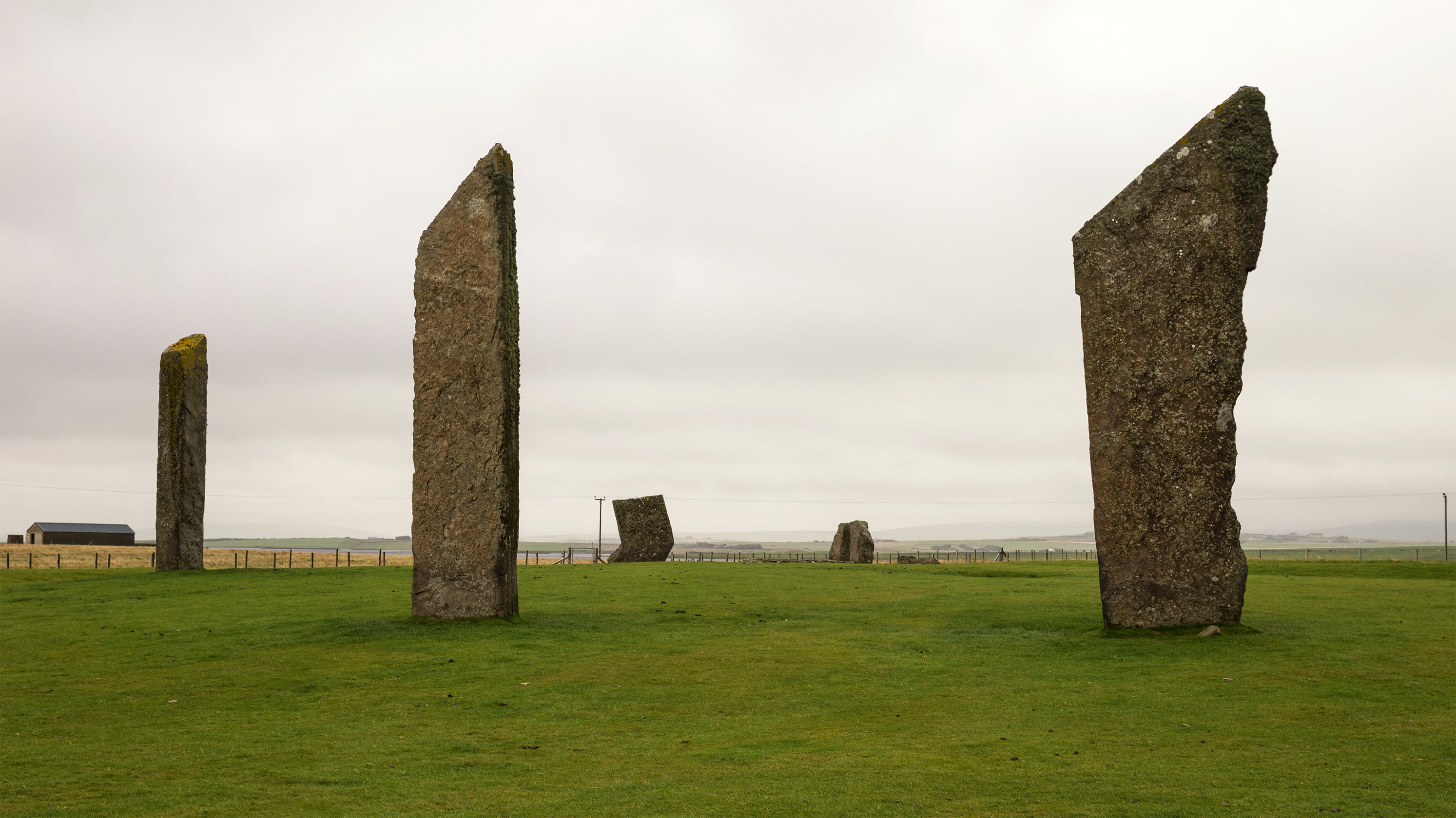
- Four tall slabs remain from an ellipse planned for about twelve stones, which may never have held more than ten or eleven.
- A rock-cut ditch and a central hearth, with grooved pottery, burnt bone, and the remains of cattle, sheep, and a large wolf or dog, place the gatherings in the centuries around 3100 to 2900 BC.
- In December 1814 a tenant destroyed the holed Odin Stone and part of the circle, fallen stones were raised again in 1906, and the ditch and sockets were excavated in 1973 and 1974.
- The circle was inscribed in 1999 with Maeshowe, the Ring of Brodgar, and Skara Brae as part of the Heart of Neolithic Orkney.
Visiting
Entry is free and the Stones of Stenness are open all year round.
History
The Stones of Stenness are a late Neolithic henge and stone circle on the Mainland of Orkney, on the headland between the salt Loch of Stenness and the fresh Loch of Harray. Four thin slabs still stand on a levelled platform, the tallest of them measured at 5.7 metres, in an ellipse of about thirty by thirty-two metres. A ditch cut into the rock enclosed the platform, with one causeway on the north facing the settlement at Barnhouse.
Animal bone from low in the ditch and charcoal from the centre have been read as dates in the centuries around 3100 to 2900 BC. The centre was a square stone setting, called a hearth, with cremated bone, charcoal, grooved pottery, and a flint flake. Cattle, sheep, and a very large wolf or dog lay in the ditch, and two human hand bones lay in a higher fill. Food was cooked and eaten here, and the pots belong to the grooved ware that developed in Orkney early in the third millennium BC.
The circle stood in the same landscape as the village of Barnhouse, the tomb of Maeshowe, the Ring of Brodgar, and the buildings on the Ness of Brodgar. Later readings connect the stones with houses, with the dead, and with gatherings at the turning of the year, and those readings remain interpretations. People returned in the Iron Age, leaving pottery and charred barley in pits south of the hearth.
Norse speakers gave the headland its name and attached the god Odin to a holed stone north of the ring. Couples swore oaths by joining hands through the hole, and the sick were passed through it. In December 1814 a tenant smashed that stone and damaged the circle. Fallen stones were raised in 1906, a rebuilt dolmen was partly taken down in 1972, and excavation in 1973 and 1974 recovered the ditch, the sockets, and the dates.
On 2 December 1999 the circle was inscribed with Maeshowe, the Ring of Brodgar, and Skara Brae. Some stones had been set up again, and the dolmen was a reconstruction, but the monuments are judged to remain largely in place. The open ground between the lochs still shows how the tomb, the circles, and the houses were aligned.
Images




Detailed History
The Stones of Stenness stand on the Mainland of Orkney, on a low promontory where the salt Loch of Stenness meets the fresh Loch of Harray. The name is pronounced in the old way of the islands, and it comes from Old Norse for a headland of stone. The circle is about five miles northeast of Stromness. The Ring of Brodgar lies about three quarters of a mile to the northwest, across the narrows, and the chambered tomb of Maeshowe lies about the same distance to the east.
For a long time the name Stones of Stenness was used for the standing stones of both headlands. Later writing kept it for the smaller monument and gave the larger circle its own name.
The place is a henge and a stone circle of the Neolithic. Four great slabs still stand. They are thin, about a foot thick, with sharp angled tops. In the excavation the tallest of the circle leaned slightly inward and measured 5.7 metres high and 1.4 metres across.
The next leaned slightly outward and measured 5.3 metres high. Later descriptions round the height up to as much as 6 metres, and a seventeenth-century account put stones of this group at about twenty feet above the ground, six feet broad, and a foot or two thick, smooth and without carving. The slabs were set on a levelled platform about 44 metres across. Their plan is an ellipse of about 30 by 32 metres, not a true circle, with the long axis lying roughly north and south.
The entrance of the surrounding ditch faces north, toward the Loch of Harray and the settlement at Barnhouse.
A ditch was cut around the platform, into the rock. One section found the base cut about a metre into solid rock across a width of about four metres, with the full depth of the section about 2.3 metres. Other descriptions put the ditch at not less than four metres wide and two metres deep, or at about seven metres wide and two metres deep. There was a single causeway on the north, and one later reading gives that entrance a width of about eight metres.
Geophysical survey has been read as a hint of a second entrance on the south, but that reading has not been tested by excavation. An earth bank once stood outside the ditch. Ploughing has almost removed it. In the 1770s the monument was described as a semicircle made by a mound of earth, with stones inside, unlike the Ring of Brodgar, which was described as having a ditch.
A watercolour of 1772 seems to show a crescent of bank on the southwest. By 1848 only about a third of a raised ring survived, and it was no higher than the low dome of ground inside the stones. Trenches in 1973 and 1974 found the bank reduced to a thin band of clayey soil and silt, about 6.5 metres wide on the west and only about 0.4 metres high at its centre. The excavator took that smear for the last of an outer bank, built from the upper spoil of the ditch.
No old land surface was found beneath it.
That reading has been questioned. One estimate puts the spoil of the ditch at about 1,300 tonnes, and it has been asked whether a bank of that mass could vanish so completely. The clay band has instead been read as the foundation spread of a wall, of the kind later found around Maeshowe and around the great buildings at Barnhouse and on the Ness of Brodgar. The bank that a visitor sees now is the result of consolidation in the 1980s.
Water still lies in the hollow of the old ditch. Aquatic plants in the fill, and the way the ditch flooded during the dig, have been taken to mean that water stood in it at least some of the time, and perhaps that a water-filled ditch was part of the design.
The builders seem to have planned twelve stones. What was raised is less certain. Sockets, stumps, and packing show a ring, but two places in the circuit are doubtful. One hole had been filled with redeposited till and had no packing and no stump.
If a stone ever stood there, it and its supports were removed with unusual care. Another hollow is so slight that it is unlikely ever to have held a monolith. A later reading of those holes is that ten stones were raised at most, and perhaps only that, and that the ring was never finished. The excavator left the question open.
He thought an ellipse was intended, and he noted that a finished ditch might mean stones were taken away later rather than that the plan was abandoned halfway. He also compared one empty hole with a stone circle at Cultoon on Islay, where a socket seems to have been filled because the work stopped. The order of building was not proved. He suggested that the stones were raised before the ditch was fully dug, because the uprights would have been easier to move on an open platform.
If the ditch is later, the stones could be older than the dates taken from the bottom of the ditch.
The stones were meant to stay. Their sockets are deep, from about 0.7 to 1.2 metres, and they were packed with stone. The megaliths came from several quarries, at least five, including Vestrafiold, and they were brought to the headland. Permanence is clearer here than at the Ring of Brodgar.
The adjacent ground at the time of building seems to have been open grassland, with some cereal grown nearby. Wood in the ditch is most likely drift timber. Orkney was already almost without trees.
Dates from the ditch and the centre do not all name the same moment, and the numbers have been read in more than one way. Animal bone in the organic deposit low in the ditch gave a laboratory determination of 2356 bc, with an error of 65 years. Charcoal in the central stone setting gave 2238 bc, with an error of 70 years, and that figure belongs to the second phase of the setting, after a possible timber post. Wood from a small timber structure gave 1730 bc, with an error of 270 years, too wide to pin the structure down.
In the excavation report those figures were corrected into the earlier third millennium for the henge and its grooved pottery. Public accounts since then place the work at about 3100 to 2900 BC, from bone in the ditch, and describe the circle as perhaps the earliest henge in Britain and Ireland, built about 5,400 years ago. A 2017 reanalysis of Orkney radiocarbon dates has been read as moving the animal bone at the bottom of the ditch to about 2900 BC. Those dates come from animals in the ditch, not from the sockets of the stones.
If the ditch was dug to enclose a circle that already stood, the stones could be earlier still. The world heritage nomination places use, and probably building, between about 3100 and 2700 BC, and use of the central features between about 2950 and 2500 BC. The figures disagree in detail. They agree that this is a monument of the late Neolithic, in the centuries when grooved pottery was made in Orkney.
The centre of the ring was a square setting of four large blocks, about 2.1 by 1.9 metres, set in bedding trenches. Flat slabs lay on the fill. One part of the interior was red and held flecks of cremated bone and charcoal. The bone was too broken to name, and because cremated human bone was not found elsewhere on the site it may be animal.
The other part of the fill was black earth with crushed charcoal, a little bone, pottery, and a flint flake. The setting is called a hearth, and a hearth is still visible. It had a long history of rebuilding. A paved path, further stone settings, and a possible second hearth marked an approach to it.
Pottery and animal bone show that food was cooked and eaten here. A timber post had stood at the centre before the stone setting of the second phase. North of the hearth, a pair of stone sockets, later filled in, lined up with a small timber structure about two metres across, with corner posts and shallow slots. The two stones may have been a porch for that wooden setting, and they may have been taken down when the wood was dismantled.
The excavator could not fully interpret the interior.
The pottery joins this monument to the grooved ware of the late Neolithic. The Stenness sherds were placed in the Clacton style: flat bases, straight or slightly open sides, and grooved or incised lines. One rim from the centre has an internal bevel and lines drawn in a stab-and-drag technique, on fine ware turned pink by later burning. Another vessel from a pit is a flat-bottomed pot, dark brown, gritted, with a fine buff slip.
A further rim is of the earlier Neolithic western tradition, but a groove under the bevel was read as a link to the grooved sherds beside it. Grooved ware seems to have developed in Orkney early in the third millennium BC, perhaps out of earlier Unstan bowls, and it was then taken up in Britain and Ireland. It was not a style brought from the continent, unlike the later beaker pottery. The typical pot is flat-bottomed, with sides sloping out and grooves around the top.
Some carry complex geometry, and some have applied bands that have been argued to copy wicker baskets. Pots range from cup size to very large vessels. Many come from henges and burials, so a ritual use has been suggested as well as cooking and serving. The earliest examples are Orcadian.
At Stenness the grooved ware was not the same, in character, as the pottery of Skara Brae, and the report warned against treating all Orkney grooved ware as one culture. Unstan ware belonged to people with different burial customs, and the two traditions coexisted. Some chambered cairns mix the architecture of the Maeshowe group with the stalled cairns of the Orkney-Cromarty group.
Beyond the pottery, the style spread south. It was used by the builders of the first phase of Stonehenge, and it is abundant at Durrington Walls and at Marden in Wiltshire, where feasting on pork is part of the record. One proposed route is trade up the west coast of Britain. Cumbrian stone axes reached Orkney, and some henges have been read as points on that movement.
None of that makes Stenness a copy of a southern circle. The dates put the Orkney pottery at the early end of the tradition.
Animal bone in the primary ditch fill was wolf or dog, domestic ox, and sheep. Most pieces were jaws or the ends of limbs, the parts left when meatier joints or workable bone had been taken. A left tibia was so large, and the muscle attachments so strong, that it was judged to be from a fully adult wolf rather than a dog, and it was the largest tibia in a small comparison that included Grimes Graves, Quanterness, and Skara Brae. A higher fill, after the first silt, held more wolf or dog, cattle including one large ox, and two bones from human hands.
A later account of the same excavation places a human finger bone, and a fragment of femur that may also be human, at the entrance causeway. The bone could be waste from food, from sacrifice, from clothing, or from the making of tools. The excavator thought food or sacrifice the more likely, given the kind of site, but the bones do not by themselves prove a rite. Cremated bone at the centre was not shown to be human.
Sir Walter Scott, standing here on 16 August 1814, wrote that the broad flat stone near the middle had probably been an altar for human victims. That was his reading of a fallen slab. The excavation did not confirm it.
Plant remains from the ditch and from later pits add the farming year. Pollen and seeds point to grassland and to the growing of barley and oats, with a decline and then a return of cultivation. The ditch was still about a metre deep in places in the nineteenth century, so some of those changes may have been packed into a short time. Charred grain from pits south of the hearth was barley, both hulled and, in the identifiable grains, the only cereal named, though pollen showed other cereals as well.
A specialist warned that a ritual site is a poor place to reconstruct a crop-processing sequence. The grain from one pit was dated to about AD 519, with an error of 150 years. That is a different age from the Neolithic ditch.
The settlement at Barnhouse stood by the Loch of Harray, not far from the circle, and the entrance of the henge faces it. Colin Richards found the village in 1984. Digging from 1986 to 1991 uncovered the footings of at least fifteen houses. They share the central hearths, wall beds, stone dressers, and drains of early Skara Brae, but they stood free rather than under one mound of midden.
Grooved pottery, flint, and a piece of pitchstone thought to come from Arran were found there. The houses sat around an open space used for pottery, flint, bone, and hides. House 2 was double the usual size, better built, rebuilt as many as five times, and used for the whole life of the village. The settlement is placed around 3000 BC and seems to have been left around 2600 BC.
After that, Structure 8 was built partly over the old houses. Its room is about seven metres square, with walls about three metres thick, and the passage faces northwest so that the midsummer sun sets along it. A clay platform surrounds it, and the way through that platform is aligned on Maeshowe. The building is taken for a ceremonial house rather than a home, and it is thought to be closely linked with the Stones of Stenness.
Some hearth slabs from it may have been moved to the circle. Another suggestion is that the Stenness hearth itself was brought from the edge of Barnhouse, from the ground where Structure 8 was later built, which would tie the circle to the village while people still lived there. The same researchers have said there is no reason the circles were not built up stone by stone, each one marking a person, a kin group, or an ancestral body. That is a proposal, not a record of named dead.
Maeshowe, less than a mile away, uses huge uprights at the corners of its chamber, and stalled cairns such as Unstan and Midhowe divide their interiors with pairs of uprights. Stone and the dead sit together in the architecture of the district, whether or not each Stenness slab was a memorial.
A further reading treats the interior as a great house that lost its walls. The hearth, the path, and the porch resemble the plan of a late Neolithic house, and Structure 8 at Barnhouse made that comparison sharper. In that account the walls were taken down, the hearth was enlarged, the open interior was then enclosed by the tall stones, and the ditch was the last and hardest boundary. Posts may have stood before some of the stones.
About seventy metres northwest of the circle, excavation in the early 1990s found sockets of the lost Odin Stone's setting, and one socket held both the trace of a post and the scar of a stone that had been pulled out in prehistory. Wood rots and stone does not. The change has been compared to flesh becoming bone, and to an argument made at Stonehenge that timber belonged to the living and stone to the ancestors. Those are interpretations offered for a sequence that the 1970s dig could not prove.
The Watch Stone stands outside the circle to the northwest, 5.6 metres high, near the modern bridge toward the Ring of Brodgar. It is about 170 metres from the henge. A second stone once stood nearby. In 1930 its stump was found about thirteen metres from the Watch Stone, set in a hole cut in the shaly rock and packed with small stones.
It measured about 1.4 metres by 0.13 metres and at least 0.9 metres high, and it is no longer visible. The Barnhouse Stone stands about 700 metres to the southeast. Both outliers are likely to belong with the henge, though that link is not proved by a joining layer of soil. The Ness of Brodgar lies across the bridge on the opposite peninsula.
Its great buildings were in use in the same centuries, including Structure Ten with its enclosing wall, and the two boundary walls of the Ness. The circle was an imposing part of that landscape while the village and the Ness complex were lived in and rebuilt.
What the monument was for is not written down, because this was a world without writing. The best guess offered by its guardians is that people used it for ceremonies that held the living and the dead in one relationship. Feasting is the activity the finds support most plainly: pots, a hearth rebuilt over a long time, and the meat bones of cattle and sheep. Aubrey Burl, the British archaeologist of stone circles who lived from 1926 to 2020, pictured families coming to Stenness at a set time of year with bones of the dead, skulls and long bones, and the skulls of totem animals, driving a beast to be killed for the feast.
He had been principal lecturer in archaeology at Hull College, and he was called the leading authority on the stone circles of Britain. He was wary of the stronger claims of archaeoastronomy. In his work on Avebury he argued that circles and henges were less likely to be observatories for a class of astronomer priests than places of rite, tied to death, fertility, and ancestors, at turning points of the year such as the spring equinox and the summer solstice. His picture of Stenness is an image of that argument, not a description of a recorded gathering.
He also compared the three-stone settings of other circles, including the cove at Stanton Drew, to the sides of an unroofed sentry box. The Stenness stones that were later rebuilt as a dolmen may have been a setting of that kind, either three uprights or a flat stone leaning on a pair.
The people who dug the ditch and raised the slabs were farmers of the late Neolithic. The Neolithic, a name coined in 1865, is the last part of the Stone Age, when farming, herding, and settled life took hold in different regions at different times. In Britain the first farming is placed around 4000 BC. By the time of Stenness, Orkney had villages of stone houses, chambered tombs, and a pottery of its own that other regions copied.
The islands lie about fifteen kilometres north of the Scottish mainland, across a hard stretch of water, yet the finds include pitchstone from Arran and, in the wider pattern, axes of Cumbrian stone. This was not an isolated farm. The four principal monuments of the district, Stenness, the Ring of Brodgar, Maeshowe, and Skara Brae, are evidence for domestic life, ceremony, and burial together, from roughly 3000 to 2000 BC in the terms used for the whole group. They sit in a bowl of hills from Hoy to the east, and they were placed so that one can be seen from another.
The open ground still lets a visitor understand that arrangement.
The same centuries, far to the south, were the early centuries of Ancient Egypt. Ancient Egypt emerged as a state along the Nile around 3150 BC, when Upper and Lower Egypt were united under a king the later record calls Menes, whom most Egyptologists identify with Narmer. Its history then runs through the Old, Middle, and New Kingdoms, broken by intermediate periods, until the Greek and Roman ages. A statement of the significance of the Orkney monuments sets them beside the mastaba tombs of the first and second dynasties of that archaic age, beside the brick temples of Sumer, and beside the early cities of the Harappan tradition, and a century or two before the early historic age of China.
The point of the comparison is not that Orkney took its rites from the Nile. It is that a farming people at the edge of the Atlantic was building in stone, on a monumental scale, at the same time as those older centres. Stenness is described in that statement as an early and particular expression of the customs of the people who buried their dead in tombs like Maeshowe and lived in villages like Skara Brae.
The circle was not abandoned forever after the Neolithic. South of the hearth, five pits held sherds of Iron Age pottery and burnt grain. The style of that pottery has been used to narrow the activity to about 50 BC to AD 300, while charcoal from one pit has been cited at about AD 100 and about AD 1050, and the grain date from the excavation sits near AD 519 with a wide error. The numbers do not collapse into one year.
They show people at the stones again in the Iron Age, and perhaps later. When the tallest stone was put back in 1906, Iron Age sherds, including a fluted rim, were found beneath it. Those sherds later passed into the Hunterian collection. Reuse of Neolithic buildings in the Iron Age is common in Orkney.
The old stones were already ancient, and they were respected, altered, or lived among. A suspected broch, Big Howe, stands a short distance away, and Iron Age material lies on the mound of the Ness of Brodgar.
The Norse centuries renamed the headland, and they attached a new god to an old stone. Odin, from the Old Norse Óðinn, is the head of the Æsir in the stories written down in medieval Iceland, a god of the dead, of war, of poetry, and of magic, who sacrificed an eye for wisdom and hung for nine nights to win the runes. Most of those stories survive in the Prose Edda of the thirteenth century and in the earlier poems of the Poetic Edda, long after the circle was built. The holed stone north of the ring became the Stone of Odin.
It stood nearer the tip of the peninsula, about 150 yards north of the ring on one nineteenth-century measure. Couples plighted themselves by holding hands through the hole. The promise was called the Vow of Odin, or the Oath of Odin. Other oaths were made in the same way.
Infants were passed through the hole against illness, and sick limbs and heads were offered to it. A folklorist who wrote up the stone for the excavation report found no other holed stone in which the curing power and the binding oath were combined in this way. A folk tale told how Thorodale, who freed Eynhallow from the Fin Folk, crawled nine times on bare knees around the stone at midnight under nine full moons, and looked through the hole for the power to see the hidden island. The number nine is a mark of Odin in the Norse poems: nine nights on the tree, nine songs, a feast at Uppsala every nine years lasting nine days.
The tale is a late story about the stone, not a Neolithic rite. Another custom, remembered as having ended twenty or thirty years before an eighteenth-century account, brought people to the kirk of Stenness at the new year for days of dancing and feasting, and sent couples to the Temple of the Moon and the Temple of the Sun to swear before the god they called Wodden. Those temple names were already in print in 1716, and they were still heard when Edward Fitzgerald came in 1841. The crescent bank may have encouraged the moon name.
The god and the temples belong to the Norse and later imagination of the place. They are not evidence for the names used in 3000 BC.
Antiquaries wrote the circle down from the late seventeenth century. James Wallace, in an account of the islands cited from 1684, placed a round of big smooth flagstones at the south end of a causeway of stones where the loch is narrowest, each about twenty feet high. Through the eighteenth century the record is a semicircle: four stones standing, a stump, and a broad stone lying near the centre. George Barry's history of 1805 gives a semicircle of sixteen fathoms, formed by a mound, with a very large broad stone on the ground, and he would not decide whether that stone had once stood like the others or had been raised on pillars.
Lady Stafford etched the same stones in 1805. A watercolour associated with the Banks visit of 1772 shows the group and a crescent bank. Sir Walter Scott came on 16 August 1814. He was a Scottish poet, novelist, and historian, Sheriff-Depute of Selkirkshire, and 1814 was the year his Waverley novels began.
He saw the fallen central slab and called it an altar. In December of that year the tenant, Captain W. Mackay, a newcomer who held the farmland, began to destroy the stones. He said local people were trespassing and disturbing the ground with their rites, and he later admitted that he had pulled stones down to strengthen the fields.
He smashed the Odin Stone. He toppled one stone of the circle and broke another before he was stopped. He had meant, he said, to leave two or three standing, including the one on the point of the peninsula. Feeling ran so high that a summary complaint was brought by the procurator fiscal.
On 15 January 1815 the papers were sent to the sheriff depute. Peterkin, the sheriff substitute, recorded the case. No further trace of the proceedings has been found. Mackay wrote letters of regret to local authorities, among them Captain Edmonston, commander in Orkney.
For the rest of the century only two stones of the circle remained upright, with one fallen and the stump of another. Sheriff Peterkin wrote that three stones had been torn up and shivered to pieces.
The broken stones in the north of the interior were gradually read as a cromlech or dolmen. Plans by Lieutenant Thomas and by Dryden and Petrie show two supports and a capstone, one support upright and one fallen. Tudor, between 1878 and 1880, described a leg two feet high still in place and the capstone remaining. In August 1885 Augustus Pitt-Rivers, as Inspector of Ancient Monuments, noted four large stones of a dolmen, one of them upright.
In November 1905 the proprietor, Colonel Balfour, received two separate appeals. Cathcart Wason, a member of parliament, had asked the Viking Club to take up the decay of Stenness and of the Ring of Brodgar. The Society for the Protection of Ancient Monuments sent an architect, who in January 1906 said the fallen upright could be raised with careful cradling, but that the central cromlech was too broken to restore. John Abercromby wrote separately to urge work on the area.
In April 1906 the Office of Works took the Stenness monuments, including the Ring of Brodgar and Maeshowe, into guardianship. The fallen stone was raised that summer. A photograph of 31 August 1906 shows the work finished, with a timber frame and a gang of about eight men. Another stone was found and set up, and a stump was put back into a socket in 1907.
The dolmen was built in the interior, and one account places that rebuilding in 1908. It was a reconstruction, and it was not accurate. In October 1972 the capstone was pushed off. The two uprights were left.
The excavation that followed lasted seven weeks in 1973 and 1974. It was done for the Department of the Environment to decide what the dolmen stones were, and to recover the plan of the circle, the bank, and the ditch. No detailed account had been published before, apart from an inventory description. The dig located the rock-cut ditch, the sockets of missing stones, the central setting, and the denuded bank, and it confirmed that a plan of the bank made in 1851 was broadly right.
It showed a structure close to where the dolmen had been rebuilt, and the stones were left in the arrangement thought most likely to be original. Packing at the foot of the tallest stones may itself date from the 1906 consolidation. One stone hole, disturbed when a monolith was toppled, held shattered fragments and a trench that looks like the work of destruction rather than of building. The results were published by J.
N. Graham Ritchie, with a separate account of the Odin Stone by Ernest W. Marwick, and with reports on the animals, the plants, and the Iron Age pottery.
In 1893 an etching of the circle was made by Francis S. Walker, an Irish painter, illustrator, and etcher who lived from 1848 to 1916. He had trained in Dublin, moved to London as a wood engraver, and from about 1880 worked as an etcher, later a member of the painter-etchers' society. The etching is one of the late antiquarian images of the stones, after the destruction and before the excavation.
The Odin Stone, already broken, continued to draw artists and musicians. Julian Cope, the English musician and writer born in 1957, singer of the Teardrop Explodes and author of The Modern Antiquarian in 1998 and The Megalithic European in 2004, used the Odin Stone on the cover of his album Discover Odin. Loreena McKennitt, the Canadian singer and composer born in 1957, set her song Standing Stones, on the album Parallel Dreams, at this place. The words tell of lovers who meet at the Odin Stone and of a death that follows.
A picture of the stones has also been used on an album cover by Van Morrison. These works are modern responses to the oath and the ring. They do not add a fact about the Neolithic.
On 2 December 1999 the Heart of Neolithic Orkney was inscribed as a World Heritage Site. The World Heritage Committee is the body that selects sites for that list. It is a committee of twenty-one states, elected for a term that the convention sets at six years and that many states voluntarily cut to four, and it is advised by professional bodies on nature and on monuments. The Orkney group that it inscribed comprises Maeshowe, the Stones of Stenness, the Ring of Brodgar, and Skara Brae, with other burial and settlement sites still unexcavated.
A minor change to the boundary was inscribed in 2015. The property is about fifteen hectares, inside a much larger buffer. The nomination treats the four monuments as masterpieces of early architecture and as a landscape that shows a significant stage of history, the age of the first great ceremonial monuments in this part of Europe. It also records the limits of what survives.
Some stones at Stenness and at the Ring of Brodgar were put back up in the nineteenth and early twentieth centuries, and the dolmen at Stenness was built and then reconfigured. Antiquarian drawings show the earlier state, and the monuments are judged to remain largely in place. The landscape is open and easily changed by small developments. Footfall and coastal erosion are named among the physical threats to the group.
The stones themselves stand inland between two lochs, while the erosion risk falls most heavily on the coastal settlement in the same inscription.
Other stone circles belong to the same broad family of monuments and to none of this history. The Almendres Cromlech, near Évora in the Alentejo, is the largest existing group of structured menhirs in the Iberian Peninsula and one of the largest in Europe. Its building is placed in the sixth millennium BC, with phases around 6000, 5000, and 4000 BC, and about ninety-five granite monoliths arranged in circles and ellipses. It was found again in 1966 during geological fieldwork.
It is older than Stenness and belongs to the megalithic landscape of Évora, not to Orkney. Auld Bourtreebush is a large Neolithic circle near Portlethen in Aberdeenshire, about twenty-five metres across, thought to have held up to fifteen orthostats, of which four still stand. A ring cairn inside it has been destroyed. It was once taken for a recumbent circle, and that idea is now rejected.
It stands near the recumbent circle at Aquhorthies and near the Causey Mounth, a medieval track on the high ground between Stonehaven and Aberdeen. In 1639 a Covenanter army used that road. The Aberdeenshire circle and the Portuguese cromlech show how widely people set up rings of stone. They do not explain the ditch, the hearth, or the oath at Stenness.
What was at stake on the headland was a way of gathering. A farming community that built stone houses and stone tombs also cut a ditch into the rock and raised slabs taller than a house. The finds show food, fire, and a careful centre. The interpretations add the dead, the ancestors, and the turning year, and they remain interpretations.
What changed is the monument itself. Stones were left unraised or were pulled out. The ditch silted and was ploughed. Iron Age people dug pits and left pottery under a falling stone.
Norse speakers renamed the headland and the holed stone. A tenant broke the Odin Stone and part of the circle in a single month of 1814. Guardianship in 1906 raised what had fallen and invented a dolmen that 1972 undid. The excavation of 1973 and 1974 gave the ditch, the sockets, and the dates back to the place.
The circle is now one of four monuments by which the late Neolithic of Orkney is known, and the open ground between the lochs is still the setting in which they were aligned.
Sources
- Standing Stones of Stenness — Wikipedia
- The Stones of Stenness, Orkney — Society of Antiquaries of Scotland
- Stones of Stenness: history and stories — Historic Environment Scotland
- Plan your visit: Stones of Stenness — Historic Environment Scotland
- Heart of Neolithic Orkney — UNESCO World Heritage Centre
- The Stones of Stenness — Ness of Brodgar Project
- Barnhouse Settlement — Wikipedia
- Grooved ware — Wikipedia
- Stones of Stenness.jpg — Wikimedia Commons
- Standing Stones of Stenness 062015.jpg — Wikimedia Commons
- Orkney - Standing Stones of Stenness (3720948239).jpg — Wikimedia Commons
- Orkney, UK - panoramio (2).jpg — Wikimedia Commons
- Orkney Standing Stones of Stenness 2017 03.jpg — Wikimedia Commons
- Orkney Standing Stones of Stenness 2017 01.jpg — Wikimedia Commons
- Orkney Standing Stones of Stenness 2017 02.jpg — Wikimedia Commons
- Orkney Standing Stones of Stenness 2017 04.jpg — Wikimedia Commons
- Orkney Standing Stones of Stenness 2017 05.jpg — Wikimedia Commons
- Orkney 2018 2.jpg — Wikimedia Commons