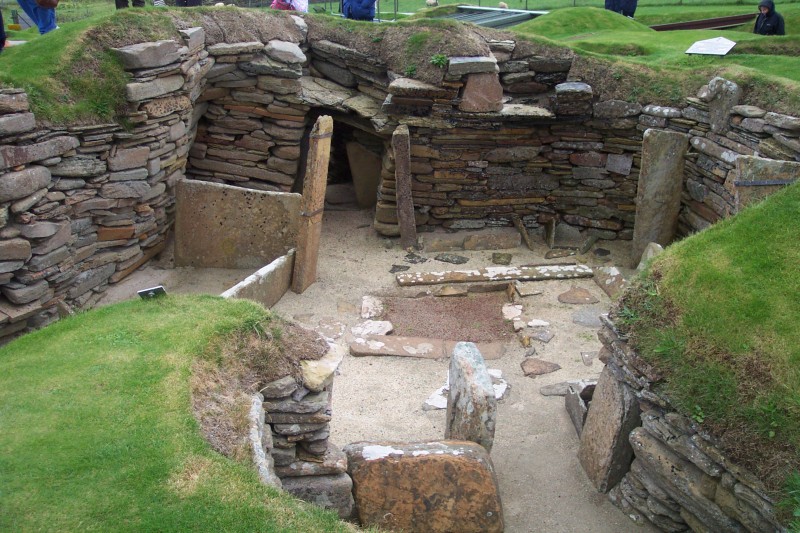

Orkney Islands, United Kingdom · Neolithic · 3181 BCE – 2501 BCE · United Kingdom
- Skara Brae is a stone-built Neolithic village on the Bay of Skaill, on the west coast of Mainland in Orkney, with hearths, box-beds, dressers, and drains still in the houses.
- The dated occupation runs from the late fourth millennium BC into the middle of the third, with a break when sand buried the earlier homes, though the published ranges do not all match.
- People here kept cattle, sheep, and pigs, grew barley at first, fished close to shore, and used Grooved Ware in a late Neolithic landscape of tombs and stone circles.
- A storm in 1850 uncovered the mound. The site was taken into state care in 1924, and Vere Gordon Childe recorded the houses at the end of that decade.
- It is one of the four principal monuments of the Heart of Neolithic Orkney, inscribed in December 1999, and the sea now stands against the protecting wall.
Visiting
The site is open daily from 9.30am to 5.30pm from 1 April to 30 September, and daily from 10am to 4pm from 1 October to 31 March. Last entry is one hour before closing. It is closed on 25 and 26 December and on 1 and 2 January. Online tickets cost £14 for an adult aged 16 to 64, £11 for a concession visitor aged 65 or over, and £7 for a child aged 7 to 15.
Tickets bought in person cost £16, £13, and £8. Member admission is free. A concession ticket requires proof of age. Admission for a child under 7 is free, and a child under 16 must be with an adult.
Booking online in advance is recommended, because a ticket is not guaranteed on arrival. From 1 April to 31 October the ticket includes Skaill House. From November to March the ticket is for the village only and the price is lower. If the village is closed, a reduced ticket can be bought on arrival for the exhibition and the visitor centre.
Dogs are not allowed except assistance dogs, which are permitted. Personal photography is welcome. Visitors with disabilities pay the standard admission, and proof of disability is not required. Up to two carers with a disabled visitor receive free admission.
The path from the visitor centre is about 500 metres, some sections are about 50 centimetres wide, and steps mean a visitor may not enter every part of the route. The visitor centre has level access and an adapted toilet. The cafe is open daily until 31 October.
History
Skara Brae is a stone-built Neolithic village on the southern shore of the Bay of Skaill, on the west coast of Mainland in Orkney. The houses now stand at the edge of the sand, and the sea is held off by a wall. Ten structures and four passages can be seen, with stone furniture still in place, though other counts speak of nine dwellings or of remnants of at least twenty-eight structures. It is one of the most complete Neolithic villages in western Europe, and one of the four principal monuments of the Heart of Neolithic Orkney, inscribed in December 1999.
The name comes from the mound, not from a village people already called by that name. Brae is the Scots word for a slope. Skara goes back to forms such as Skerrabra and Skerrabrae. Early writers also called the place a weem, the Underground House of Skaill, or simply Skara.
When the houses were lived in, the shore lay further west, about half a kilometre or about 500 metres, perhaps as far as the mouth of the bay, beyond dunes and maybe a freshwater lagoon.
Occupation is dated in two ways that should both be kept. Samples from 1972 and 1973 were read as a start about 3180 BC, a span of about six hundred years, and an end around 2500 BC. A later model places the whole use between some time in 3360–3160 cal BC and 2545–2440 cal BC. An early phase with probably round-based pottery falls in that first range.
Grooved Ware houses then belong to a shorter Phase 1, perhaps only about fifty years, before sand buried the settlement around 2870–2760 cal BC, or around 2800 BC. People returned and rebuilt until about 2545–2440 cal BC. Childe first suggested about 500 BC, and a film lecture says 3100 BC.
The houses were free-standing, with double drystone walls packed with clay, sand, ash, and refuse, and probably a roof of eel-grass thatch. Seven of them share a hearth, a larger box on the right and a smaller one on the left, and a shelved dresser opposite the door. The boxes have long been called beds, though one account says that role is not proved. Doors were barred from inside.
Clay-sealed floor boxes, called limpet boxes, and stone drains served the later houses. Passages began as open gaps and were roofed only in the later phase.
The people kept cattle, sheep or goats, and pigs, grew barley at least in the early phase, and caught cod and saithe close to shore. Deer were a small part of the bone. Grooved Ware, heavy pins, beads, and carved stone objects have been read as signs of rank in a society that was not equal, against a popular picture of a commune of identical houses. The same pottery spread far south.
Neighbours included Barnhouse, the Ness of Brodgar, Maeshowe, and the Stones of Stenness. A track leaves the village and runs toward the great cairn.
The end is told both as a sudden flight from a storm and as a slow burial after people had already left. Anna Ritchie rejects the catastrophe. Later burials on the spot belong to other ages, from the Beaker period to the sixth or seventh century AD. The usual rediscovery is the storm of 1850, though a note of 1769 has been argued over.
William Watt of Skaill House dug the north-eastern houses. Credit is also given to William Graham Watt, or to his son Black Willie. Vere Gordon Childe recorded the village at the end of the 1920s, with Margaret Simpson and other women students whose part was only widely recognised much later. David Clarke and Anna Ritchie dug again in 1972 and 1973 and put the date in the Neolithic.
The whalebone figure called the Skara Brae Buddo, lost after George Petrie drew it, was found again in 2016. In 2021 a grave at the Links of Skaill was dated to the time the village was in use. In 2026 work continued on beads made from tooth roots. A climate assessment in 2019 judged the place extremely vulnerable to the sea.
Orkney Islands Council shares the care of the monument. More than 100,000 people a year came before the pandemic, and they look down into the rooms from a path because the ancient interiors are not opened to the daily crowd.
Images


Detailed History
Skara Brae is a stone-built Neolithic settlement on the southern shore of the Bay of Skaill, on the west coast of Mainland, the largest island of Orkney. The houses stand at the edge of the sand, in machair grassland, and the sea is now against the protecting wall. One measured point places the remains about 9.5 kilometres north-west of Stromness. Ten structures and four passageways can be walked around today, together with stone furniture still in place.
Another count says nine dwellings survive, all but one of them visible from the path. A fuller survey speaks of remnants of at least twenty-eight structures, of which parts of ten buildings and four passages are visible, and of a possible twenty identified from the work of the 1920s with eight more from the digging of 1972 and 1973. The settlement is one of the most complete Neolithic villages known in western Europe, and one of four principal monuments of the Heart of Neolithic Orkney, inscribed in December 1999. A small change to the boundary of that wider designation was inscribed in 2015.
The name is modern, and it keeps an older mound-name. Brae is the Scots word for a slope or a hillside. Skara comes from earlier forms such as Skerrabra, Styerrabrae, and Skerrabrae, first applied to the grassy knoll that covered the houses, not to a village anyone then knew by that name. Early writers also called the place a subterranean dwelling or weem at Skara in the Bay of Scales, Sandwich, the Underground House of Skaill, and simply Skara.
Scales and Sandwich are old spellings of the bay and of Sandwick. The archaeological name settled on the village only after the mound was dug.
When people lived here the shore lay further west. One account puts the coast about half a kilometre away, another about 500 metres, and another as far out as the present mouth of the bay. The houses may have stood on a ridge between freshwater lochs, or beside a lagoon sheltered by dunes, in pasture with remnant woodland and scrub. Rounded building stones look like beach stones rather than quarried blocks.
The thinner slabs used for beds and shelves are more likely to have been quarried. Dunes gave some shelter, but sand was already blowing in during the life of the village. Once the dunes went, salt and sand made cultivation harder. Geophysical survey suggests further structures inland, to the south, which could as much as double the known settlement, though those traces have not been dug and their date is not fixed.
Orkney’s earliest farming communities are placed between roughly 3800 BC and 2500 BC. A distinction is drawn between an earlier and middle Neolithic, about 3800 to 3200 BC, and a late Neolithic, about 3200 to 2500 BC. The first settlements seem to have been small farmsteads, built in timber until clearance made timber scarce, and then in stone. The dead were placed in passage tombs and in stalled cairns, the stalled chambers divided by upright slabs.
Pottery and tomb plans show contact across the Pentland Firth, and from about 3600 or 3500 BC a shared bowl form, the Unstan bowl, shows contact with the Outer Hebrides. Those links required boats that could cross open water. From at least about 3500 BC some burial monuments grew larger, which has been read as growing difference in status, with building used as a form of competition. Aşıklı Höyük, a settlement mound on the Melendiz brook in Aksaray Province in central Turkey, was already old by then.
It was first settled in the aceramic Neolithic, around 8200 BC, and its main occupation runs from about 8200 to 7400 BC. It covers about four hectares, smaller than the nearby mound of Çatalhöyük, and its obsidian travelled as far as Cyprus and Iraq. Nothing in the Orkney record joins that Anatolian village to the Bay of Skaill. It belongs to a much earlier experiment in living in one place.
The late Neolithic in Orkney brought new pottery, new monuments, and clusters of houses. One reading sees a dominant group of prosperous farmers in the west of Mainland setting themselves at the centre of a new order. Barnhouse, by the Loch of Harray near the Stones of Stenness, was occupied from the thirty-second century BC. Its houses, dug between 1986 and 1991, have central hearths, beds, stone shelves, and drains, and they stood free of one another.
At least fifteen houses were traced there, and one of them is a double house. A larger building at Barnhouse, and others at Links of Noltland on Westray and at the Ness of Brodgar, look like places for gatherings rather than ordinary homes. Links of Noltland has dressers in two areas of Neolithic building, one of them set into a wall recess opposite the door, in the manner of the earlier houses at the Bay of Skaill. Part of that Westray settlement was enclosed by a wall.
Skara Brae was established several generations after Barnhouse, in the late thirtieth or the twenty-ninth century on one reading of the dates, and it went on being lived in after Barnhouse had ended and after the early third-millennium flowering of the Ness.
The Ness of Brodgar stands on the narrow neck of land between the lochs of Stenness and Harray, close to the Stones of Stenness, the Ring of Brodgar, the Ring of Bookan, and Maeshowe. It may have begun in the later fourth millennium as an ordinary settlement using round-based pots. Stone houses with flat-based Grooved Ware were in use before the thirtieth century, and from that century oversized buildings with stone piers replaced them. A huge communal building, Structure 10, with at least three enclosing walls, existed by the thirtieth century.
A wall about four metres thick crosses the isthmus on the north-west, and a wall up to two metres thick stands to the south-east. People feasted there, made and sometimes deliberately broke carved stone objects, including maceheads, and obtained pitchstone and volcanic tuff from Great Langdale in Cumbria. One reading is that the great buildings housed visitors drawn to the west Mainland for monuments and for midwinter gatherings. The dating suggests that this phase was over by about 2800 BC.
Fieldwork at the Ness ended in August 2024, and the work since then has been analysis and publication. The Ness is not one of the inscribed monuments, though it carries much of the explanation of the landscape around them. It is unclear whether the Ring of Brodgar itself was built while Skara Brae was lived in. The Stones of Stenness, a circle with a surrounding henge, were built during the thirtieth century BC.
The Ring of Brodgar may have been raised some four or five hundred years later, perhaps with Avebury in mind, but its dating is poor.
Maeshowe is a great chambered cairn whose long passage points close to midwinter sunset. Its plan, a high central room with three side cells, resembles the great passage tomb at Newgrange in the Boyne Valley, though the Orkney tomb is smaller and faces the setting sun rather than the rising sun. The masonry is exceptional. Most of the passage is built of huge sandstone slabs, the largest estimated at three tonnes.
Motifs from Irish passage-tomb carving appear on lintels of Maeshowe-type tombs and on some Grooved Ware, including pots from Skara Brae. The Orkney vole, which must have come by boat from continental Europe, is another sign of those sea journeys. Not every late Neolithic person was buried in a chambered cairn. A complex cist at Sand Fiold, just over a kilometre north-east of the bay, was used for several centuries from the late Neolithic onward.
In 2021 a cist with a well-preserved contracted skeleton was excavated at the Links of Skaill, directly east of the bay, and dated to 3260–2910 cal BC, a time when the village was in use. Isotope and DNA work on that person was still going on when the site’s significance was last set out in 2024.
Grooved Ware is the flat-based, often decorated pottery of this late Neolithic. It was in use at Barnhouse by the thirty-second century BC, and it spread quickly south, as far as Cornwall, Essex, south-west Ireland, and the country around Stonehenge. With it went a style of heavy jewellery in bone and marine ivory, and carved stone objects that could wound — skulls from Cuween Hill have holes the size of a macehead or a carved stone ball — but that above all marked rank. The people of Skara Brae used Grooved Ware, large dress pins, chunky beads and pendants of whalebone and sperm-whale ivory, and carved stone pieces.
On that evidence they have been argued to belong to an important lineage in a society where not everyone was equal. A different, popular account treats the houses as all of one size and the village as a genial commune without a tribal hierarchy. The measured houses are not all one size. House 1 is the largest of those still visible.
House 2 is smaller, with a truncated oval interior. House 9 is smaller again and trapezoidal. The ornaments are hard to reconcile with a village of equals, though the day-to-day sameness of the furniture is real.
The dates of occupation are given in more than one way, and both should stand. Radiocarbon samples from the excavations of 1972 and 1973 were first read as a start about 3180 BC and a span of about six hundred years, with an end around 2500 BC after the climate grew colder and wetter. A later Bayesian model puts the whole use of the site between some time in 3360–3160 cal BC and 2545–2440 cal BC. Within that, an early phase, Phase 0, with pottery that was probably round-based, falls some time between about 3360 and 3160 cal BC.
The first Grooved Ware occupation, Phase 1, is dated between 2920–2850 cal BC and 2870–2760 cal BC, and the earliest houses still standing are also placed from 2920–2885 cal BC. That phase may have lasted under a century, perhaps only about fifty years, or two generations. Sand then seems to have buried the settlement, around 2870–2760 cal BC, or around 2800 BC in a shorter statement of the same break. People returned, rebuilt, and remodelled older houses, including an early form of House 7, within 2840–2685 cal BC, and Phase 2 lasted until 2545–2440 cal BC.
A separate account of the visible ruins says most of them belong to a final period of about 2900–2500 BC, and that only Houses 9 and 10 belong to the earliest excavated phase. Vere Gordon Childe at first placed the village around 500 BC. A film lecture gives the date as 3100 BC. Those figures are not the radiocarbon results.
Childe’s own first publication treated the place as Pictish, which he took to mean late Iron Age, while also suggesting a local culture that might be called Stone Age and yet stand beside Iron Age sites further south. He thought he saw Baltic, even Arctic, traits. J. Graham Callander, then keeper of the National Museum of Antiquities of Scotland, published the objects in 1931 and concluded that the site was Iron Age.
The underground look of the houses, and likenesses to brochs, pulled the date late. Stuart Piggott recognised the pottery as what he called Grooved Ware as early as 1936, but he then thought that tradition was early Bronze Age. A parallel with Neolithic pottery from Clacton pulled the village back before the Iron Age. By 1954, in The Neolithic Cultures of the British Isles, Piggott treated Skara Brae as a key Neolithic site, and a motif from its pottery was used on the cover.
Jacquetta Hawkes, born Jessie Jacquetta Hopkins on 5 August 1910 and died on 18 March 1996, was the first woman to take the archaeology and anthropology degree at Cambridge, dug Neanderthal remains at Mount Carmel with Yusra and Dorothy Garrod, and in 1986 published a shell guide to British archaeology in which this settlement sits among the prehistoric sites of Britain. Aubrey Burl, born on 24 September 1926 and died on 8 April 2020, wrote The Stone Circles of the British Isles in 1976 and Prehistoric Avebury in 1979, and argued that circles and henges were places of seasonal ritual, tied to death, fertility, and ancestors, rather than observatories staffed by astronomer priests. He was wary of the stronger claims of archaeoastronomy. That caution belongs beside a theory, offered by Euan MacKie, that Skara Brae housed a privileged theocratic class who performed astronomical and magical ceremonies at the Ring of Brodgar and the Stones of Stenness.
Graham and Anna Ritchie found no archaeological evidence for that claim. A Neolithic low road does leave the village, pass near both circles, and end at Maeshowe, so the places were connected on the ground, whatever the ceremonies were. The Goseck Circle in Saxony-Anhalt, built around 4900 BC and apparently used until about 4700 BC, is a much older circular enclosure, a ditch about 75 metres across with two rings of posts and entrances aligned on the winter solstice, and smaller gaps on the summer solstice. It is presented as a ritual structure.
Marketing has called it one of the oldest solar observatories, but the solstice alignments are the only astronomical pattern emphasised in the remains. It was found in 1991 by Otto Braasch from cropmarks, dug from 2002 by François Bertemes and Peter Biehl, and opened to visitors on 21 December 2005 after a reconstruction with 1,675 oak poles. No source ties that German circle to the Orkney village.
The houses were free-standing, not cellars. They were built with two skins of drystone wall, the cavity packed with clay, sand, ash, and household refuse, which insulated the rooms and steadied the walls. Clay, probably local, clad many outer faces. Watt, as reported by George Petrie, already noted walls coated with clay, and William Balfour Stewart and William Boyd Dawkins saw the same.
Early houses were bedded on a natural clay. Roofs do not survive on the dwellings. A turf or thatch roof is assumed above the stone wall-heads, and the work of the 1970s points to thatch of local eel-grass. Childe sometimes called the outer packing midden.
Later study treats that packing as building material, and keeps the word midden for true heaps of household waste. Debris on the passage roofs may mostly have gathered after people left. The monuments of this group have been set beside the mastabas of the first and second dynasties of Egypt, the brick temples of Sumer, and the first cities of the Harappan tradition, and a century or two before the early flowering of historic China. A visitor account instead says the village is older than Stonehenge and older than the Egyptian pyramids.
Both comparisons are in circulation. Charles Rennie Mackintosh, the Glasgow architect and designer born on 7 June 1868 and died in London on 10 December 1928, is not named in the digging or the building of this place. The use of turf, clay, ash, and waste has been held up as a model for later builders, but that is a modern reading, not a link to his work.
Seven houses share a plan. A low door, often offset a little to the right, was closed by a stone slab and a bar of bone that slid in holes cut in the jambs. The bar could be worked from inside. A claim that the door of House 7 could be fastened only from outside has been disproved.
A hearth of edge-set slabs sits at the centre, sometimes with a taller stone toward the shelf. On either side are slab-built boxes, the one on the right always larger than the one on the left. Childe read the boxes as beds. That reading has stuck, and beads and paint pots in some of the smaller boxes have been used to support it.
Lloyd Laing noted that in the Hebrides, into the early twentieth century, the husband’s bed was the larger and the wife’s the smaller, and he set the Skara Brae pattern beside that custom. Stone boxes to the left of many doors would force someone entering to turn toward the right-hand side. Stumps of pillars at the foot of the boxes may have held a canopy of fur, another likeness Laing drew with later Hebridean houses. Another account says there is no real evidence that the boxes were beds at all.
Keeping-places, or aumbries, are cut into the wall above them. Opposite the door, and so the first thing a person sees on entering, is a shelved fitting Childe called a dresser: three stone pillars, two shelves, and two bays at the front. He also said that nothing found on those shelves showed what they were for. In Houses 1 and 7 the dresser projects from the wall.
In Houses 2, 4, and 5 it sits in a recess. Cells often open from the left bay at floor level. The same idea, a shelf or a recess opposite the door, appears at the Ness of Brodgar and at Links of Noltland, which has kept the argument alive: storage, display, or something less domestic. Small square boxes sunk in the floors of the later houses, numbered 1, 2, 4, 5, and 7, were luted with clay until they held water.
They are called limpet boxes, and limpet shells are common enough to have been bait. Drains of neat stone run under at least five houses, especially 1, 3, 4, 5, and 6, and seem to fall toward the north, though none has been followed to its end. Each house has at least one corbelled cell in the thickness of the wall, and some have as many as four.
The passages were not designed as a covered street from the start. They began as the gaps between separate houses, open to the sky. In Phase 2, Passages A, B, and C were roofed with sandstone slabs, then clay and turf. Passage A is the main east–west line, a little over a metre high and usually about 1.5 metres wide, floored with flags.
Houses 4 and 6 open from it to the south, Houses 1 and 2 to the north. Its eastern end, where House 3 stood, has probably been lost to the sea, so the original way in on that side is gone. At the west end Childe saw a doorway that could be barred, giving onto a paved space he called the Market Place, and he thought the village was unlikely to continue further west. Passage B, older than Passage A, runs south from that line, drops by steps near House 7, and becomes Passage C, which Childe’s furthest stretch he named the Lansbury Gallery after George Lansbury, a minister of works and a social reformer who visited in 1929.
A photograph places Lansbury at the site in 1930. Passage C climbs above the house floors and seems to leave the surviving settlement. Passages E and F leave a small paved area by the western gate. Passage E runs between House 2 and Structure 8.
Passage F runs south between the houses and a freestanding wall that may mark a working or farming yard. The Market Place had few finds and was full of sand. Its use is not known.
House 1, north of Passage A, was the first and most obvious chamber, and the Watt family rebuilt it. It is the type of the later house: a large central hearth, enclosures on both sides, a wider and rougher enclosure left of the door, four limpet boxes, and a dresser. An early plan by Petrie shows two cells in the north wall, one at the corner and one under the dresser, which the rebuilding left out. A small window toward the present shore is not original.
Saddle querns and pot-lids lie on the floor as the house is shown now. A painting of 1863, or 1865 in another publication of the same picture, has been used to suggest that some dresser slabs were reset, but the painting is not a reliable survey. When the house was first cleared, a contracted skeleton lay in the sand fill. In 1884 that person was identified as female.
Bone from what is probably that skeleton has been dated to 2030–1780 cal BC, after the village was abandoned. A drain once ran from the corner cell into a sluice-like structure north of the house, and the sea has taken it.
House 2, west of House 1 and apparently set against House 1’s outer wall, was entered from Passage A. It has the usual beds, hearth, limpet boxes, a dresser with a cell opening at the bottom left, and a second cell in the north-east corner. The beds keep tall corner slabs. Clay at the foot of the east wall was read as plaster.
William Balfour Stewart and William Boyd Dawkins found the house in 1913, and they examined only the entrance and the eastern wall beside House 1. House 3, east of House 1, is almost gone. A storm in 1924 finished what earlier storms had begun. Petrie’s plan of 1867 shows three uprights at the rear, probably the feet of a dresser, and early clearance uncovered the western bed, several limpet boxes, and the hearth.
A single cell left of the door, and the entrance, are almost all that remains. The whalebone figure later called the Skara Brae Buddo was found in this house.
House 4, south of Passage A, has a long straight entrance barred at the inner end, and an interior wider than many others. A stone pillar about 1.75 metres high is built into the south-east of the inner face. The east wall rests on larger boulders and was coated, when Childe recorded it, with blue clay about 0.15 metres thick. Nothing of that coat is visible now.
He also recorded a bastion of what he called midden on the east, with deep packing, and the visible stone may include an earlier House 4. The hearth lies left of the entrance. The bed spaces are less firmly ended than usual. The dresser, reduced to three pillars, is offset left.
There are limpet boxes, an extra slab parallel to the right-hand bed, and two cells. The plan has been compared with double houses such as House 2 at Barnhouse, though the likeness is not conclusive. William Watt explored it, and a plan of about 1867 by Dryden shows the fittings and the drains under the floor. House 5 shares a much-altered wall with House 4.
Its own plan is the standard one: central hearth, beds projecting into the room, limpet boxes, and a dresser with a cell from the left side. The entrance is unusually short, and Childe thought it disturbed. In 1928 a narrow passage behind the left-hand bed was opened into a tiny cell that held a stone basin or quern, two whale vertebrae, and a small grinding slab. Drains under the floor come from House 6 and from a cell in the south-east corner.
House 6, west of House 5, is two buildings. House 6 prime, to the south, is generally taken to be earlier. It is entered from Passage C, smaller than most, with a central hearth and a bed recess of the early kind, cut into the wall. Its original door is blocked, and few fittings remain.
House 6 proper, entered from Passage A, has no clear interior fittings. Childe saw thin slabs stacked inside the door, which he took for roofing slabs, a habit also noticed at Links of Noltland, and from the outer wall of House 5 he judged House 6 very late. House 7, on the south edge, was found by Childe in 1928 and is the best preserved. It sits on natural subsoil.
Shepherd gives it an early origin and later alteration. For most of its circuit it stands clear, with Passage C on the east and a wide gallery on the west that may once have been a passage. The wall is stout, with a casing on a higher bank of accumulated material. Inside it is smaller than House 1 but of the same broad shape.
The paved entrance could be closed by a bar worked from a cell that opens outward, though Clarke thought that arrangement was not the original one. Beds flank the hearth. The left bed is smaller, with tall pillars against the wall. The front slab of the right bed carries linear engraving.
A dresser stands beyond the hearth, three limpet boxes sit in the south-west corner, and a circular cell is built into the wall on the dresser’s other side. Childe read a small pit by the dresser’s left leg as a sump. Because earlier diggers had not emptied this house, he could record its contents: stone tools, potsherds, and bone jewellery mixed with food and animal waste. He called the scene indescribable filth and disorder, and he took it for a sudden flight, a snapshot like a buried city.
A later reading of the same deposit is very different. Under the right-hand bed, in a cist that runs under the wall, he found two skeletons, identified as female, and he interpreted them as a foundation deposit. Those two skeletons cannot now be located. A third skeleton lay in a cist under the turf south of the house, and a fourth, badly disturbed, lay beside it.
Childe thought those two were likely to be Norse. Alexandra Shepherd has suggested that House 7 may have ended its long life as a workshop. Visitors do not go inside it. A turf roof replaced a glass roof in 2007, to ease the heat on the walls.
A replica near the visitor centre is the interior people can enter. A laser scan made around 2010, as part of a project that recorded ten Scottish sites in detail, allows a view of the real room.
House 9, east of House 7 and reached from Passage C, is early and simpler. Only a few courses remain. The interior is trapezoidal. The original door was altered into a later cell, but a bar-hole and one door-check survive.
Recesses either side of a central hearth were divided into beds, which Childe called corbelled. Dresser supports stand opposite, in a small recess. There are no limpet boxes. A cell opens from the southern corner.
Shepherd suggests Passage C may once have ended here. House 10, further east, is vestigial. Childe called it hopelessly ruined. It seems to have had two cells.
A couple of internal slabs and the lower supports of a dresser are what can be seen. Houses 12, 13, and 14 were found in 1972–73 and cannot be seen. Houses 12 and 13 are early, under the latest walling south of Passage A and under the casing of House 7. Only parts were uncovered: House 12 a segment with a double skin and a paved bay, House 13 a curve of wall and a scrap of floor.
House 14 belongs to Phase 2. It is a small arc of wall, later cut by the last stage of Passage A, with a central hearth and little other furniture, and it may have been a workshop or an outbuilding.
Structure 8, also called House 8, stands west of the rest, beyond the Market Place and Passage E. It is free-standing, oval inside, with a central hearth but without a dresser or the slab beds. A porch, which Childe thought added later, may have opened both east and west before the west side was blocked, and a fragile slab roof survived over that porch when the building was found. The interior had been made smaller.
Wide recesses flank the hearth, with many aumbries, and a narrow opening leaves to the north where a dresser would be, off a recess divided into compartments. Childe found many heat-cracked volcanic stones there and just outside, ash over and in front of the hearth, an unusual amount of flaked chert, and piles of clay. He suggested a kiln or other hot work, flint knapping, and pottery making. Another account gives the walls as over two metres thick, about 6.6 feet, and speaks of bone needles or flint axes, heat-damaged volcanic rock, and a flue.
The same building has been placed later than the Grooved Ware houses, perhaps after the late Neolithic, even in the early Bronze Age. Its age and its use are both still argued. The paved Market Place between it and the houses is not explained by the few objects in the sand that filled it.
The early houses, to judge from Houses 9 and 10 and from what lies under the later floors, were more nearly circular, with the boxes set into the walls, and they stood apart, perhaps with a jacket of turf, as has been proposed for Barnhouse. Test pits dug by Childe met earlier walls beneath the visible ones, and in places the deposits were two metres deep. Later houses grew more rectangular, with rounded corners, and the boxes projected into the room, giving a cross-shaped plan shared with other late Neolithic buildings in Orkney. The passages of the later phase knitted houses that had not been designed as one organism.
An unknown number of buildings had already gone into the sea before 1850. House 3 is the clearest loss. What remains is an impression of a single village, not a complete plan.
Food and fuel are known from bones, seeds, and the hearths, and they limit what can be said about daily life. The people were chiefly pastoralists, keeping cattle, sheep or goats, and pigs, with cattle the main animal. Deer bones are under two percent of the animal bone, so hunting was real but slight. Bird bones, often made into awls, and eggshell are present in small numbers.
Barley was grown. Childe had thought the inhabitants did not farm. Seed grain from a midden, found in 1972, showed that they did, at least in the early, pre-Grooved Ware phase. Cereal growing seems to have stopped after Phase 0.
Fish bones, mainly cod and saithe, fish that can be taken close to shore, are common, and limpets may have been the bait kept in the clay-sealed boxes. People also gathered plants. Puffballs are interpreted both as food and as a staunch for wounds. A twisted skein of heather, found in the waterlogged levels of 1972, is one of the very few pieces of Neolithic rope from Britain, and other short lengths are of crowberry stem.
A wooden handle survived in the same wet layers. Childe was sure the hearths burned peat. A study of the vegetation finds that thick peat did not form in this part of Orkney until after the village was abandoned. Driftwood, animal dung, and dried seaweed are the other candidates, and seaweed was widely used.
At some Orkney sites a glassy slag called kelp, or cramp, may be burnt seaweed. The earliest known record of the human flea in Europe comes from this settlement. Coprolites, mostly from dogs, have been scanned, and lipids in the pottery have been analysed. Those studies were still being drawn together long after 1973.
The 1970s dig itself was described, decades on, as nearing publication, and the fuller report has been referred to as still forthcoming.
The objects are unusually rich because shell sand is alkaline and because part of the site stayed wet. Flint and chert tools are many. The characteristic coarse stone tool is the Skaill knife, a large flake struck from a sandstone beach cobble, thick at one end for the hand, and named by Childe for this bay. Such knives occur across Orkney and Shetland.
Grooved Ware jars of up to about thirty litres were found in several houses. Much of the pottery from the 1920s clearance was thrown away, so the early collections favour the larger, tougher objects. Bone and ivory work includes awls, needles, knives, beads, adzes, shovels, small bowls, and pins of ivory up to about 25 centimetres, or 9.8 inches, long. Similar pins occur in passage graves in the Boyne Valley.
Carved stone balls from the village, some of them with spiral ornament, have been set beside objects from the same Irish cemeteries, and similar marks are cut on lintels and bed-posts. Those marks have been called runic writings and given contentious readings. Rodney Castleden suggested that colon-like dots between vertical and slanting signs might divide words. Red ochre, found here and on other Neolithic sites, has been taken as a sign of body paint.
Nodules of haematite with polished faces may have been used to finish leather. Whalebone vessels and a whalebone figure sit with the rest. Antonia Thomas has made the fullest study of the incised stones. Much of the art is angular rather than curving.
More may be hidden inside walls, as at the Ness. Childe warned that a scratch made by a trowel can come to look old, so a few marks could be of the twentieth century. The great majority are accepted as ancient.
The figure called the Skara Brae Buddo was found by William Watt in House 3 in the 1850s or 1860s and drawn by George Petrie in a notebook. It was then lost, and the drawing was all that remained. In 2016 David Clarke found it again in a box in the stores of Stromness Museum, where it is now shown. It is thought to be about 5,000 years old.
Four holes sit where eyes, a mouth, and a navel would be. Buddo is an Orcadian word of endearment that does not specify gender. Beads are a separate bulk of the collection. More than 5,000 are estimated from antiquarian clearances between the 1890s and 1930 and from David Clarke’s excavations in the 1970s.
They are divided among the British Museum, National Museums Scotland, Orkney Museum, and Stromness Museum. In 2026 Emma Jones reported on the portion made from the roots of teeth, about seventy percent of the beads. With support from the Orkney Archaeological Society, the Society of Antiquaries of Scotland, and the University of York, she has used zooarchaeology by mass spectrometry and amelogenin analysis, measured pieces in London and in Orkney, and was due to speak in Kirkwall on 1 October 2026. The questions are which animals were chosen and how the beads were made.
Most other finds are held by National Museums Scotland, by Orkney Museum for Orkney Islands Council, and by the Orkney Natural History Society at Stromness Museum. Some belong to Scottish ministers and are shown, with loans, in the visitor centre at the site.
Why people left is not settled, and the accounts disagree on purpose. Around 2500 BC, or by 2545–2440 cal BC at the end of Phase 2, the village was given up. One popular telling has a storm taking the inhabitants by surprise, as at a buried Roman town. Necklaces of animal teeth and bone, and pins of walrus ivory, were left behind.
Joints of choice meat were found in some of the beds and have been called the remains of a last meal. One woman is pictured breaking her necklace in a narrow doorway and scattering beads down the passage as sand came in. Anna Ritchie rejects that catastrophe. Burial in sand was gradual, she argues, and the houses had already been abandoned, for a reason nobody can demonstrate.
Childe’s reading of House 7 was the sudden-flight version, and he thought the village had been left at the height of its life because furniture and goods were still in place. Climate and a wetter, colder turn may have mattered. So may the breaking of the early third-millennium social order. Plague, or some other pandemic, has been named as a possible cause of wider collapse, and as a question for further research, not as a fact proved at this site.
After the end there are signs of squatting, including a bead made from a horse tooth dated to 170 cal BC–cal AD 10, in the Iron Age. Human bones were also brought in, or buried, later. A femur from Passage A, found in a corner leaning against the wall near a triangular cell outside House 1, dates to the second half of the third millennium BC, after the village. The woman in the sand of House 1 dates to 2030–1780 cal BC, the time of Beaker pottery in Orkney.
A skull also found by Watt dates to cal AD 540–640. In 1994 fragments of a human skull were seen eroding from the wave-cut bank south-west of the houses. The rest of that adult man, and the cist he lay in, were dug in 1996 and dated to cal AD 543–687. Childe’s two burials south of House 7, which he thought Norse, are a further late use of the ground, if his reading of them holds.
Other digging around the bay shows that the village was not alone in its landscape. In the winter of 1992–93 storms exposed a late Neolithic butchery place about 100 metres west, or in another description about 100 metres south-west, separated by a short wall from a deposit of articulated red deer. It was excavated in 1994. There were no houses there.
In the same year a skull and animal bones were recorded in the storm beach just west of the settlement, under broken stone. Fieldwalking closer to the Loch of Skaill in 1984 found a thin scatter of worked stone that may be late Neolithic. At the north end of the bay, eroding material has been read as a possible second settlement. On the hill at Vestra Fiold, further north, a Neolithic quarry for standing stones has been identified, and there are chambered cairns nearby.
In 1977 Clarke opened trenches west of the old museum building and found possible boundary walls, not obvious houses.
The rediscovery has its own dispute. The usual story is the winter of 1850, when a severe storm struck Scotland, killed more than two hundred people, and stripped the earth from a large irregular knoll in the Bay of Skaill. Local people then saw the outlines of small roofless houses. William Watt, described as the son of the local laird, a self-taught geologist living at Skaill House and working as a clerk, began to dig.
One account gives the credit to William Graham Watt of Skaill House, son of the laird, and says that after four houses the work was abandoned in 1868. Another says William Graham Watt, 1776 to 1866, seventh laird of Breckness, is usually credited, but that the digging was more likely the work of his illegitimate son with Janet Inkster, also William Watt, known as Black Willie for his hair and complexion. A third wording says the investigations were organised by William Watt, son of the laird, and that they ran from 1850 to 1867, often with visiting antiquaries, among them George Petrie of Kirkwall and James Farrer from Durham. What was cleared in that generation was the north-east: Houses 1, 3, 4, and 5, and much of Passage A, with rebuilding in House 1.
The site was then left open to the weather until the 1920s. Ernest Marwick, writing in 1967, called the idea that nobody knew the place before the storm of 1850 a complete fiction. He pointed to James Robertson’s tour of Orkney and Shetland in 1769, which describes square catacombs in the Downs of Skail and, in one of them, a skeleton with a sword in one hand and a Danish axe in the other. Sigurd Towrie has answered that this most likely means Bronze Age cists on the slopes of Sandfiold, east of the bay, not these houses.
One of those cists has also been read as holding Viking grave goods, so the identification is still argued. It remains possible that the village itself was first seen in 1850. Wilson’s paper of 1851, using news sent by Petrie straight after the discovery, is the first publication.
In 1913 the site was disturbed again. One account says that in a single weekend a party with shovels plundered it and took away an unknown quantity of objects. The only recorded investigation of that year is the work of William Balfour Stewart and William Boyd Dawkins, who pushed west along Passage A into House 2 and examined the entrance and the eastern wall. In 1924 another storm tore away what was left of one house, House 3, and the place was taken into state care by a guardianship agreement.
One account says the trustees of W. G. T. Watt made that transfer.
A sea wall was begun in 1925 and has been the village’s main defence ever since. Clearance of the overburden is dated in one account to 1925–26, under a contractor, John Firth of Kirkwall, hired by the Office of Works, with Vere Gordon Childe put in charge in the winter of 1926–27, almost as soon as he had taken the Abercromby chair at Edinburgh. Another account dates the public clearance to 1927, under the local contractor J. Wilson Paterson, and Childe’s contract to 1928, the year the monument was scheduled, in March.
Childe is also said to have travelled to the site for the first time in the middle of 1927. The excavation was his first in Scotland. It lasted three seasons. He recorded ten stone houses linked by three main passages, over drains and earlier buildings.
The best preserved, House 7, still had its furniture, which led him to think the village was abandoned in full occupation. His team was local labourers and women archaeologists. Margaret Simpson, who studied with him and is thanked in his monograph, became the first professional woman archaeologist in Scotland in 1930. For most of the twentieth century the women were easy to miss in the record, because their part was written down less clearly here than at his dig on the chambered cairn at Kindrochat in Perthshire in 1929.
Photographs of Childe with four women, long treated as tourists or local visitors, were re-examined in 2019. A note on the back calls them four of his lady students. They have been identified, tentatively, as Margaret Simpson, Margaret Mitchell, who was the only student to finish a doctorate with him, Mary Kennedy or Mary Kathleen Kennedy, and Margaret Cole or Dame Margaret Cole.
Childe at first saw four phases. David Clarke later folded the story into two. Alexandra Shepherd has since split each of those into early, middle, and late, and has added Phase 0 for the round-based pottery before Grooved Ware. The sand around 2800 BC, or in the modelled window 2870–2760 cal BC, is the gap between the main occupations, followed by rebuilding.
After Childe, the site was not dug again for about forty years, though he kept it in his wider writing on early farming. In 1972 and 1973 David Clarke and Anna Ritchie directed new excavations for the National Museum of Antiquities of Scotland, the University of Edinburgh, and the Department of the Environment, mainly to recover dates and the environmental evidence Childe’s methods had missed. Two trenches were opened. One lay between Passage A, Passage B, and House 7, and produced structural remains of at least nine further buildings, plus artefacts and a mass of animal and plant remains.
The other lay east of House 4, near one of Childe’s test pits. Waterlogged deposits preserved the rope and the wooden handle. Decorated Grooved Ware, worked bone, flint, stone, worn pumice, marine shell, and animal bone came out in quantity. The results moved the interpretation from an underground settlement to free-standing houses, clay-clad and probably thatched with eel-grass.
Publication of that campaign has been described as still being finished. Small later investigations have followed erosion outside the village proper.
Care of the monument has been continuous, and the sea has not stopped. The wall was extended and consolidated in 1963, with further repairs, including work in 1990 and 1993, and the latest completed repair ran from 2009 to 2011. Beach levels in front of the wall are dropping, and the toe of the wall is being strengthened in stages. A laser survey of the houses and the beach has been repeated about every two years from 2010 to 2021, at a scale of millimetres.
In 2019 a climate assessment by the heritage body, Orkney Islands Council, and others judged the whole Heart of Neolithic Orkney, and this settlement in particular, extremely vulnerable, because of rising sea level, heavier rain, and storminess. One unusually severe storm could destroy part of the village. Flooding here is expected mainly from waves and spray, not from a simple rise of still water. The existing wall still does its job, and the risk is kept under review.
The monument was inscribed in December 1999 with Maeshowe, the Ring of Brodgar, the Stones of Stenness, and associated stones including the Barnhouse Stone and the Watch Stone. It was described as the first archaeological site in Scotland designated for its cultural value. The four places together are taken to show domestic life, ceremony, and burial in a tradition flourishing between about 3000 and 2000 BC, which is a wider bracket than the modelled dates of this one village. The designated area is drawn tightly, matching the ground in state care, and does not take in Barnhouse or the Ness, though both support the value of the group.
A buffer in two parts, one around the bay and one around the monuments of central west Mainland, is meant to protect the sight-lines. The property is about fifteen hectares, and the buffer about 6,258 hectares. The islands lie about fifteen kilometres north of the Scottish mainland, and the two clusters of monuments are about 6.6 kilometres apart. Threats named for the group are the wear of visitors’ feet and the erosion of the coast.
Orkney Islands Council, the local authority for the islands since 1975, based at School Place in Kirkwall, shares the management with the heritage body, with NatureScot, also known as Scottish Natural Heritage, and with the Royal Society for the Protection of Birds. The council was created from Orkney County Council and the town councils of Kirkwall and Stromness, and it is also the harbour authority for the islands’ piers. In 2023, under its leader James Stockan, it debated whether Orkney was fairly funded within the United Kingdom and looked at other constitutional models, including those of the Channel Islands, the Faroe Islands, and an overseas territory, and even a return to Norway. That argument was about the modern council, not about the Neolithic houses.
In February 2024 Heather Woodbridge became leader at the age of twenty-nine. The council’s museums hold part of the finds.
Public presentation has changed with the research and with the number of visitors. The site is open most of the year. Before the pandemic it drew more than 100,000 ticketed visits a year, and in 2019–20 nearly 114,000. A visitor centre was begun in 1996 and opened in 1998 with the replica of House 7.
Three test pits south-east of the houses, dug before that building, found nothing. In 2000 a new perimeter fence was watched by archaeologists, who recorded occupation deposits south of House 7 and found a bone point, two cobble tools, and six Skaill knives. Paths were altered in 2006 to improve access, and the watching brief reported no disturbance. People now come through the centre, can enter the replica, and then follow a path to the ruins.
One account of 2023 gives that walk as about 350 metres. An assessment of 2018 gives about 400 metres. The current visiting information gives about 500 metres, through a latch gate, on bound crushed stone. At the houses the route is one way, on stone and grass, and some stretches are about fifty centimetres wide, with steps and handrails to some areas.
General entry into the ancient rooms is not allowed, because the daily numbers are too high. Evening guided visits for a few people are offered sometimes, and they are advertised when they happen. Skaill House, the seventeenth-century house of the family who dug the mound, stands nearby. One description puts it about 300 metres from the ruins.
The visitor information puts it about 140 metres from the visitor centre, and says it is run separately. Between 1 April and 31 October, entry to the house is included with the village. From November to March the ticket is for the village only. A capacity system asks people to book ahead.
Along the path, stones are marked with the dates of later events, counting back toward the Neolithic. Some areas were closed in parts of 2020 and 2021 during the pandemic.
The place has also been used by later writers, and their pictures are not all the same as the excavation. Kathleen Fidler, born Kathleen Annie Fidler on 10 August 1899 in Coalville and died on 7 August 1980, wrote more than eighty books for children. The Boy with the Bronze Axe, published in 1968, is set in the last days of this village. Rosemary Sutcliff’s Shifting Sands, of 1977, also tells a gradual leaving.
Kim Stanley Robinson’s novelette of 1991, A History of the Twentieth Century, with Illustrations, sends its main character to the ruins and to other Neolithic sites in Orkney. Bill Bryson, born William McGuire Bryson on 8 December 1951 in Des Moines and a British citizen from 2014, published At Home: A Short History of Private Life in 2010. In the chapter called The Setting he uses the village, uncovered in the storm of 1850, as a picture of early domestic life, older in his telling than Stonehenge and the pyramids, with nine houses still holding many of their contents, walls up to ten feet high, locking doors, drains, dressers, beds, water tanks, damp courses, covered passages, and a marketplace, and with houses all of one size, which he reads as a genial commune. The measured walls, the house-by-house differences, and the ornaments of rank are the other side of that description.
An Irish traditional group took the village’s name and released an album under it in 1971, reissued in 1998. A lecture in a film of 2008 gives the date 3100 BC. A commemorative stone was unveiled at the site on 12 April 2008 for the anniversary of Yuri Gagarin’s first orbit of the Earth in 1961. In 2025 a board game about the village, for one to four players, was released by Shem Phillips.
In April 2024, documents from the excavation of the late 1920s were reported as destined for the Orkney Library and Archives. The statement of the site’s significance, updated in 2024, was drafted in large part by Caroline Wickham-Jones, who died in February 2022 before it was finished.
What remains unknown is as definite as the furniture. The full plan inland has not been tested by excavation. The original number of houses lost to the sea cannot be counted. The use of the dressers, the boxes called beds, the limpet tanks, and the Market Place is inferred.
The fuel is not proved. The reason for the final leaving is not proved. Structure 8 may not be part of the late Neolithic village at all. Some human remains from the early digs cannot now be found.
The 1970s excavations are still described as awaiting their full publication. The sea wall is holding, and the next severe storm is the risk the climate assessment names. The houses that do survive, with their hearths, shelves, and drains, are still the clearest domestic interior of this period in northern Europe.
Sources
- Aubrey Burl — Wikipedia
- Skara Brae — Wikipedia
- Heart of Neolithic Orkney — UNESCO World Heritage Centre
- Plan your visit: Skara Brae — Historic Environment Scotland
- Skara Brae — Historic Environment Scotland
- Skara Brae: Statement of Significance — Historic Environment Scotland
- From Bone to Bead: Research Update — AncientCraft
- Skara Brae: the houses — Ness of Brodgar Project
- Was there more to Neolithic dressers than just a set of shelves? — Ness of Brodgar Project
- Skara Brae — Working Stone
- At Home: A Short History of Private Life — Wikipedia
- The Glittering Nest — The New York Review of Books
- Aşıklı Höyük — Wikipedia
- Bill Bryson — Wikipedia
- Charles Rennie Mackintosh — Wikipedia
- Goseck Circle — Wikipedia
- Jacquetta Hawkes — Wikipedia
- Kathleen Fidler — Wikipedia
- Orkney Islands Council — Wikipedia
- Orkney Skara Brae.jpg — Wikimedia Commons
- Ancient ruin, Skara Brae, Scotland.jpg — Wikimedia Commons
- A rocky coast by Skara Brae - geograph.org.uk - 954262.jpg — Wikimedia Commons
- Carved stone from Skara Brae bb.jpg — Wikimedia Commons
- 2018 07 12 Schottland (92).jpg — Wikimedia Commons
- 2018 07 12 Schottland (90) Skara Brae.jpg — Wikimedia Commons
- 2018 07 12 Schottland (91).jpg — Wikimedia Commons
- 2018 07 12 Schottland (93).jpg — Wikimedia Commons
- 2018 07 12 Schottland (97).jpg — Wikimedia Commons
- 2018 07 12 Schottland (94).jpg — Wikimedia Commons