
Monument
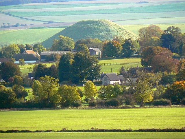
Silbury Hill
monumental Neolithic mound west of the River Kennet and south of Avebury village, Wiltshire, England, UK

Avebury, United Kingdom · 2391 BCE · United Kingdom
- Silbury Hill is a prehistoric chalk mound on a low spur beside the River Kennet, south of Avebury in Wiltshire, and it forms part of the Stonehenge, Avebury and Associated Sites World Heritage property inscribed in 1986.
- Published heights run from about 30 metres and 31 metres up to 39.3 metres, 39.5 metres, and 40 metres, and the base is given as roughly 135 to 168 metres across, because the figures are taken from different ground levels.
- It was raised in many small stages in the later third millennium BC. Accounts place the work between about 2470 and 2350 BC, from around 2450 BC for 55 to 155 years, or between about 2400 and 2300 BC, and no burial has been found at the centre.
- Shafts and tunnels of 1776, 1849, and 1968 to 1970 were left open inside the hill. A crater opened on the summit in May 2000, and the voids were packed with chalk in 2007 and 2008.
- A Roman settlement of streets and houses stood at the foot of the mound, an early eleventh-century defence may have cut the top flat, and a 2025 study identified five chips of Stonehenge bluestone from the summit.
Visiting
Entry is free, though a parking charge of £2 applies to non-members and may be paid by text or in advance, while members park free when a valid car sticker is on display. The site is open during reasonable daylight hours. Visitors are not allowed onto the hill, coaches and minibuses cannot be accommodated in the car park, and there are no designated disabled spaces. Smoking, vaping, barbecues, and naked flames are not allowed.
History
Silbury Hill is a chalk mound on a low spur beside the River Kennet, south of Avebury in Wiltshire. Several accounts call it the largest artificial mound of prehistoric Europe, and one calls it the tallest and the second largest. It stands among the Avebury henge, the West Kennet long barrow, the Sanctuary, Windmill Hill, and the timber enclosures at West Kennet, inside a World Heritage property inscribed in 1986.
Published heights run from about 30 metres and 31 metres to 39.3 metres, 39.5 metres, and 40 metres, because some measurements start on ditch silt and others near the old ground surface at the centre. The base is given as about 160 metres, 167 metres, 167.6 metres, or 135 to 145 metres across that buried surface, and the flat summit as about 30 metres or 32 to 34 metres. A later survey found straight sides at the foot, perhaps as many as nine, and a summit that is slightly square rather than round.
The builders stripped the turf, trampled the clay, and began with a gravel heap less than a metre high. Stake rings, soil, boulders, and chalk from a ditch that was cut, filled, and cut again carried the mound outward through many small additions, including a banked enclosure about 100 metres across. Labour is estimated at 18 million hours, or about 4 million, and the mass at about half a million tonnes, or roughly 239,000 to 248,000 cubic metres.
The dates agree on a late Neolithic span and differ in detail. One account places the building between about 2470 and 2350 BC, another between about 2479 and 2350 BC, and another from around 2450 BC for 55 to 155 years. Completion is placed around 2400 BC, between about 2400 and 2300 BC, or by about 2300 BC, while an older reading near 2750 BC is no longer treated as reliable, and an outer skin has been allowed as late as 2000 BC.
No central burial was found by the miners of 1776, the tunnel of 1849, or the excavation of 1968 to 1970. The purpose is unknown. Suggestions include a platform where a few people stood high above a gathering, a seasonal monument, a goddess figure traced in the ditch, sightlines toward the hills, and a long communal labour that mattered more than any final design.
The Kennet here has been read as a source that people of the time may have joined in their minds to the Thames, with the great henge at Marden in a similar position on the Avon. In those same generations, new pottery, new burial customs, and the first metalworking were arriving, and the sarsen settings at Stonehenge were going up. The mound was then left as it stood, and only a few Beaker sherds belong to centuries afterward.
Romans later bent their road from London toward Bath to avoid the foot of the hill. A survey in 2007 found a settlement of streets and houses there, about the size of 24 football pitches, laid out as a ladder of plots where the road crossed the Winterbourne. Early medieval builders probably cut the summit flat for a defence around 1010, when a coin of Æthelred the Unready, Saxon pottery, and postholes belong, and a skeleton found with a bridle in 1723 is taken to be a burial of that later age.
The tunnels of 1776, 1849, and 1968 to 1970 were never properly filled. A crater opened in May 2000, and one account places that collapse in May 2002. In 2007 and 2008 the cavities were packed with chalk, and recording inside the hill replaced an old model of three or four phases with many small episodes. In 2025 five chips of Stonehenge bluestone from the summit were identified as stone people had carried there, only one of them from a context that is securely Neolithic.
Images




Detailed History
Silbury Hill is a prehistoric artificial mound of chalk and clay on a slight natural spur on the west side of the River Kennet, south of the village of Avebury in Wiltshire. It belongs to the cluster of late Neolithic monuments around Avebury, with the Avebury henge and its stone circles and avenues, the West Kennet long barrow, the Sanctuary, Windmill Hill, and two large oval enclosures of massive timber posts at West Kennet whose remains now lie buried. The same wider landscape holds the henges at Marden and on Salisbury Plain. The mound and those neighbouring monuments were inscribed in 1986 as part of the Stonehenge, Avebury and Associated Sites World Heritage property.
A small change to the property boundary was inscribed in 2008. The property covers about 5,152 hectares in two chalkland areas, each around 25 square kilometres, and the monuments in both areas were built and used between about 3700 and 1600 BC. At Avebury the henge bank and ditch run for 1.3 kilometres, and about 180 local unshaped stones formed an outer circle and two smaller inner circles. The West Kennet and Beckhampton avenues leave two of the four entrances.
The avenue toward the Sanctuary runs for more than 2 kilometres. Silbury is named among the outstanding monuments of that Avebury group. It is called the largest artificial mound of prehistoric Europe, and also the tallest and the second largest prehistoric man-made mound in Europe, and one of the largest in the world. Its volume has been compared with the pyramids of Egypt from the same broad age.
The size of the hill is given in more than one way, and the figures do not match because they do not all start from the same ground. One measurement puts the mound at 39.3 metres, or 129 feet, from the present ground at the top of silt that has gathered in the surrounding trench. That silt is nine metres deep. Another figure is 39.5 metres, with a mass of half a million tonnes of chalk.
A further account says 40 metres, or 131 feet. Others say 30 metres high and 160 metres wide, or a little over 30 metres high and 160 metres wide. A survey that used boreholes put the height closer to the centre at 31 metres, and an older note of the same order says 31 metres with a diameter of 135 to 145 metres and more than 239,000 cubic metres of chalk. A news account of the Roman settlement called the hill nearly 40 metres high and also 34 metres, or 112 feet.
An older measurement put the hill at 130 feet high and 550 feet across the base, on a footprint of 5.5 acres. A later summary says nearly 40 metres high and about 168 metres across. The circular base is also given as 167 metres, or 548 feet, and as 167.6 metres. The flat summit is given as 30 metres, or 98 feet, across, and the borehole survey measured it at about 32 to 34 metres.
The hill is said to cover about 2 hectares, or 5 acres. The whole hill, 2.3 hectares or 5.7 acres, was notified in 1965 and again in 1986 for its grassland.
The shape is disputed in the same way. One survey of the early structures found them perfectly circular, with the centre of the flat top and the centre of the cone that describes the hill lying within a metre of each other. A later earthwork survey found that the plan is set by radial spines, like a spider's web, that the summit is slightly square rather than round, and that the base may be an octagon or a polyhedron with as many as nine straight sides. The description of the mound now on view says the same: it is not entirely circular, and straight construction lines, possibly as many as nine, show at the bottom.
The original summit may have been rounded. The flat top is widely treated as later. One account says it was flattened in the medieval period to take a building, perhaps a defensive one. Another says the Neolithic summit was probably truncated in the Saxon period when an eleventh-century fortification was put on the hill.
The present profile has a step or terrace just below the crest. That terrace was argued to be an original Neolithic feature, either a precaution against the chalk slipping or the remnant of a spiral path used to raise material and later walked as a route. A ramp runs from the ledge below the crest up to the summit, and it could be original or late. If the uppermost ledge is walked, it returns to a point lower than where it began, so the apparent terraces could be one spiral.
Other, minor terraces belong to the early eleventh century. Platforms on the lower slopes cut into the original profile and so were made after the mound existed. Around much of the circuit, the later Neolithic ground surface still shows as a slight change of slope, now several metres above the present base of the ditch, and beyond the ditch there are remnants of the old chalk surface.
The ditch is part of the monument. It was the quarry for most of the chalk. The quarries are visible as earthworks, partly filled by ploughing, and would once have been much deeper. Their greatest extent is given as 355 metres from east to west by about 240 metres from north to south, and their greatest depth now is 1.3 metres.
A linear arm runs west and breaks the otherwise even circuit. On the west the ditch widens into a tank that often floods in winter. The mound was once entirely white, because the exterior was chalk, and the ditch may have been kept full of water from underground springs. It has been suggested that the ditches were laid out as the image of a Neolithic mother goddess.
That reading remains a suggestion.
What the hill was for is not known, and the building sequence is the surest evidence of how it came to be. The monument was not designed and finished in a single campaign. The ground was cleared of topsoil and of sarsen stones, and the turf was stripped, because the mound sits directly on clay. The bare soil was then churned by many feet and perhaps by hooves, so the place was already busy before the first heap was raised.
The first structure was a gravel mound a little under a metre high, and one account says that first mound was also about 10 metres across. The gravel may have come from the Kennet. A knee-high gravel mound is the same early episode in another telling. As that heap grew it was ringed with stakes.
A later stage set a ring of stakes around a larger area, 16 metres across, and basketloads of mud and dark soil were tipped inside. Smaller heaps stood nearby, like satellites, and pits, probably tied to ceremony, were dug into the central mound. People went on adding soil, turf, and boulders until a mound about 35 metres across and about 5 metres high stood there. The first clear structural evidence is also described as a gravel core with a kerb of stakes and sarsen boulders, and then alternate layers of chalk rubble and earth.
A massive ditch with an internal bank, about 100 metres across, was then dug around it. That ditch was backfilled and recut, more than once, each time a few metres farther out. Chalk banks were added to the mound and the ditch was filled again. A second, enormous ditch, able to hold water, and a rectangular extension were dug beyond, leaving room for the chalk mound to grow again.
The large outer ditch is a later stage of that same outward movement. In one older reading the hill was built in steps, each tier packed with chalk and then smoothed or weathered to a slope, and stone and wooden fences were used to hold the material and to stop the sides slipping. That reading counted three main stages, or four broad phases: a primary mound, then chalk, then the enlargement to the present size, the primary mound being a turf stack with a stake circle, on a mound that began at about 40 metres across on the chalk spur and grew to about 160 metres by chalk rubble laid in horizontal layers. The spur was cut back by the ditch, which made the built mound look taller.
There was no clear evidence, in that writing-up, of a major pause. The recording done inside the hill in 2007 and 2008 found something else. The expected four phases were not there. The mound had grown through many small events, year after year, almost continuously, and it is doubted that a year passed without some work.
The early episodes were very small. Not every episode was a mound: at one point the main feature was a banked enclosure. The people who laid the first gravel are not thought to have pictured the hill that stands now. The form changed over decades, and the last generation at work would have had to know what their great-grandparents had imagined if a single design had been followed from the start.
The comparison drawn is with medieval cathedrals, which each generation altered. On that view, the skyline and the sightlines of the finished hill are a by-product of the process, not the aim. The builders may have been bringing pieces of the landscape together, turf from the clay under the mound and grass that had grown on chalk farther off, so that the hill was a physical gathering of their own country. Sarsen boulders in the mound need not have travelled far, because such stones were probably more common here then than they are now, but some boulders high in the mound would have taken two people to haul up the slope, so they were not the easiest hardcore.
The volume and the labour are given in figures that also disagree. One calculation is 248,000 cubic metres, or 324,000 cubic yards, and 18 million man-hours, the equivalent of 500 people working for 15 years. Another estimate is about 4 million man-hours, and half a million tonnes of material, mostly chalk. A third says many million man-hours.
A news account of the Roman discovery estimated 35 million baskets of chalk. The list of what was found in the core is short: clay, flints, turf, moss, topsoil, gravel, freshwater shells, mistletoe, oak, hazel, sarsen stones, ox bones, and antler tines. Roman and medieval objects have been found on and around the hill since the nineteenth century. The turf sealed inside is extraordinarily well preserved.
In some places the grass is still green, and moss can be recognised as having grown on a north-facing slope. Insects are preserved with them, and they give a snapshot of the surroundings at the time of building. Winged ants were used to argue that work began in August, when those insects fly. A later reading of the same insects is more cautious: ants were found, and wings were found, but the wings were not found on the ants, so the season of the work is not known, and the idea of a harvest hill is set aside.
The dates fall in the later third millennium BC, with a spread that has to be kept because the samples and the models differ. The building is placed in several stages between about 2400 and 2300 BC, and the first clear evidence is placed around 2400 BC. One account says the hill was probably completed around 2400 BC. Another says it was probably built over a short period between about 2470 and 2350 BC.
A news account gives about 2479 to 2350 BC, and also calls the mound 4,000 years old. The Roman-settlement reports called it 5,000 years old, and almost 5,000 years old, and said it was already almost 3,000 years old when the Roman village was built, or that the village stood in its shadow some 3,000 years after the mound, with a Roman community about 2,000 years ago. The conservation dating puts the start around 2450 BC and the duration at somewhere between 55 and 155 years. The midpoint is a little over a century, about four or five generations, long enough that no single leader fits as the sole driving will, and short enough that the work did not last for many centuries.
The sarsen trilithons at Stonehenge were being raised around the same time. An antler fragment from a secure context, the first of its kind on the hill, was dated to about 2490 to 2340 BC and was used to place the second phase in the late Neolithic. The turf at the centre is said to have been built within a century of 2400 BC, and the outer layer may be as late as 2000 BC. The final form is also placed by about 2300 BC.
An older radiocarbon reading on the base layer of turf and decayed material was corrected to a start close to 2750 BC, but those dates are not treated as reliable now. Unburnt vegetable matter from the turf stack was also given as 2145 plus or minus 95 years. A later list of results from the primary organic material and from antler near the base of the final ditch was given as 4095 plus or minus 5, 3849 plus or minus 43, and 3752 plus or minus 50, in radiocarbon years, and the construction was placed soon after Avebury at about 3950 radiocarbon years, or in the middle to late third millennium BC. The three largest mounds in Wiltshire, this one, the Marlborough Mound, and the Hatfield Barrow, all fall in the second half of the third millennium, and the first forms of Silbury and of the Hatfield Barrow fall in the twenty-fifth century, with Silbury finished within a few generations of that.
Work is thought to have stopped rather than to have been formally finished. The stopping coincides with the arrival of the first Beaker pottery, Beaker burials, and copper. Apart from a few Beaker sherds centuries later, there is very little sign of later prehistoric activity on the hill. The time of building was already a time of change, with new pottery, new burial rites, and the first metalworking arriving in Britain.
Hundreds of people were gathering in the Avebury area to raise monuments. The area had been a focus since the early Neolithic. Windmill Hill, a causewayed enclosure, overlooks it on one side, and the West Kennet long barrow on the other, so the mound was raised in an ancestral landscape. It also sits at the head of the Kennet, which flows to the Thames.
The modern map treats the longer tributary through Oxford as the head of the Thames. It has been argued that people then could have seen the Kennet and the Thames as one river, and that the largest henge in the country, at Marden, sits in the same kind of place at the head of the Avon. If so, both monuments mark the sources of major rivers.
Euan MacKie argued that no simple late Neolithic tribal structure, of the kind usually imagined, could have kept up Silbury and the projects like it. He pictured an authoritarian theocratic elite with wide control across southern Britain. That argument sits inside a longer case, set out in 1977, that technological achievement in late Neolithic Britain, including astronomy, geometry, and measurement, should not be dismissed as impossible merely because the societies are assumed to have been too simple. He distinguished inferences about economy and technology, which he thought could be drawn directly from the evidence, from inferences about society, which he thought had to go by analogy.
Euan MacKie was born on 10 February 1936 and died on 2 November 2020. He studied at Whitgift School, then archaeology and anthropology at St John's College, Cambridge, taking his degree in 1959, and later a doctorate at Glasgow. In 1959 and 1960 he spent six months with a Cambridge expedition in British Honduras, now Belize, at the Maya centre of Xunantunich, where layer-by-layer recording suggested a sudden destruction in the later ninth century, a partial clearance, abandonment by the elite, and then peasant occupation of the ruins. An earthquake was proposed and remains disputed.
He worked briefly at the British Museum and then at the Hunterian Museum in Glasgow, becoming keeper of archaeology and anthropology in 1974 and deputy director from the middle of the 1980s. He was elected a fellow of the Society of Antiquaries of London in 1973, retired from full-time work in 1998, and went on writing.
John C. Barrett put a different stress on the same monument. Any ritual at Silbury Hill, he wrote, would have lifted a few people far above everyone else, visible for miles and from several other monuments, and that could mark an elite, perhaps a priesthood, displaying authority. The point is made in his 1994 book on social life in Britain from about 2900 to 1200 BC.
John C. Barrett, who lived from 1949 to 27 December 2024, taught at Leeds from 1976 and at Glasgow from 1980, and from 1995 at Sheffield, where he held a chair from 2001. He argued that the people of the past, otherwise forgotten, had to be thought about one by one, and that a prehistory built only out of generalised processes missed them. His Silbury reading is that kind of argument: a few bodies raised into view, not a diagram of a society.
Michael Dames offered a seasonal cycle that took in Silbury Hill, the West Kennet long barrow, the Avebury henge, the Sanctuary, and Windmill Hill, all places from which the summit can be seen. He read the earthwork as the pregnant womb of a great goddess, and the surrounding water as her body, a symbol he placed before a patriarchal warrior society. The Sanctuary, in the same cycle, was described by Mike Pitts as the goddess in her early spring state, and the Avebury landscape as a three-dimensional fertility cycle. Lucy Lippard has made a similar suggestion about the goddess and the mound.
Michael Dames taught prehistoric design at Sheffield Polytechnic from 1964 to 1968 and art history at Birmingham Polytechnic from 1971 to 1976. He set the reading out in The Silbury Treasure in 1976 and The Avebury Cycle in 1977, and returned to the hill in Roman Silbury and the harvest goddess in 2007 and in Silbury: Resolving the Enigma.
Paul Devereux argued that Silbury and the monuments around it were laid out on related sightlines focused on the step a few metres below the summit. From barrows round about, and from Avebury, that step lines up with hills on the horizon behind the mound, or with hills in front of it so that only the top of Silbury shows. In the second case he suggested that a ripe cereal crop on the intervening hill would cover the upper part of the mound, the top of the corn and the top of the hill meeting. Paul Devereux was born in 1945 and grew up in Leicester.
He studied at Ravensbourne College of Art and Design, taught an evening class on earth mysteries, and from 1976 edited The Ley Hunter. His own conclusion on ley lines was that Alfred Watkins's alignments were chance alignments on a map, and that the idea of a mystic current along them came later, in particular from a book of 1936 and from writers who tied straight lines to unexplained aerial objects. He directed the Dragon Project, which spent years measuring stories of unusual energies at old sites, and he published the Silbury sightline argument in 1999.
Jim Leary and David Field concluded in 2010 that the purpose cannot be known. The many overlapping phases, and the near-continuous remodelling, suggest that there was no blueprint, and that the process of building was probably the important thing. Leary, who directed the fieldwork from 2007 to 2008, has also said that people simply stopped, and that the world moved on. He has asked whether the Roman townspeople at the foot of the hill revered it and kept off it, or whether a shrine on the summit was destroyed when the hill was next remodelled.
That is a question, not a found shrine. There is surprisingly little Roman disturbance of the mound itself.
Other mounds were tested to see whether Silbury was alone. The Marlborough Mound, in the grounds of Marlborough College, 8.3 kilometres or 5.2 miles east and farther down the Kennet, is 18 metres or 59 feet high, less than half the height of Silbury. It had been used for the medieval fortifications called Marlborough Castle and had been identified as a Norman motte. Jim Leary's team took cores from two boreholes 10 centimetres across.
Charcoal from immediately under that mound dated to around 2500 BC, so it is a close contemporary. The Hatfield Barrow, at Marden Henge, 10 kilometres or 6.2 miles south, had been almost levelled in the nineteenth century. A surviving fragment of what may have been a mound 15 metres high also gave dates in the middle of the third millennium BC. The Round Mound Project began in 2015.
From 154 possible mounds across England, 20 were chosen for cores and detailed survey. By late 2017, 14 had proved to have been built immediately after the Norman invasion of 1066, three were later medieval, and one was Saxon and may be a burial mound. Only the mound at Skipsea Castle in East Yorkshire was prehistoric, and it dated to 800 to 400 BC, in the Iron Age. On that survey, Neolithic mound-building of this kind was restricted to the upper Kennet and Avon valleys, and nothing still standing elsewhere in Britain comes close to Silbury Hill.
The name is older than the antiquaries, and its meaning is uncertain. A single thirteenth-century reference calls it Seleburgh. Selburi hille is on record about 1540, and Selbury is a direct derivative of that form. Silbury Hill was in use in 1663.
Legend says the hill is the last resting place of a King Sil, shown as a life-size gold statue sitting on a golden horse. A legend noted in 1913 says the Devil was carrying a bag of soil to drop on the people of Marlborough and was stopped by the priests of Avebury. In 1861 it was reported that hundreds of people from Kennet, Avebury, Overton, and the neighbouring villages crowded the hill every Palm Sunday. None of those stories is the burial the tunnels failed to find.
John Aubrey was the first to illustrate the hill. His notes were published between 1680 and 1682 in Monumenta Britannica. John Aubrey was born on 12 March 1626 at Easton Piers, now Easton Piercy, near Kington St Michael in Wiltshire, and he died on 7 June 1697. He recorded many megalithic monuments in southern England for the first time and is especially known for his systematic examination of the Avebury henge.
He discovered the megalithic remains at Avebury in 1649, later mapped them, and in 1663 showed Avebury to Charles II at the king's request. The Aubrey holes at Stonehenge are named after him, though it is doubtful whether the holes he saw are the ones that now carry the name. He entered Trinity College, Oxford, in 1642. The English Civil War interrupted those studies.
He became a student of the Middle Temple in 1646. From the early 1640s he kept notes of antiquities, natural philosophy, and his friends' ideas, and he said his memory was not tenacious by the standards of his century. In 1659 he was recruited for a collaborative history of Wiltshire, which he never finished. He also collected customs and beliefs, attempted a study of English place-names, and wrote the short biographies known as Brief Lives.
He published little in his lifetime. For much of the nineteenth and twentieth centuries he was read mainly as an eccentric gossip, and only from the 1970s was the range of his fieldwork more widely valued. His father died in 1652 and left him estates tangled with debt.
William Stukeley later wrote that a skeleton and a bridle were found during tree planting on the summit in 1723. The grave was shallow. It held a decayed skeleton, an iron knife, a Viking bridle, and deer antlers. The burial is probably secondary, and it is likely to belong around the eleventh century, with the other late Saxon material on the summit.
It is not a Neolithic burial, and it is not King Sil.
The early medieval use is the setting of that grave. The top of the hill was probably flattened, and some kind of defensive structure may have been placed on the summit. Late Saxon or early Norman pottery was found, and a coin of about 1010. A spiral walkway cut into the mound in the eleventh century is littered with Saxon pottery and a coin of Æthelred the Unready, and it can be paired with postholes on the summit that point to a fortification of the early eleventh century.
A surge of Viking raiding in the area is recorded for that time, and the local people are thought to have used the mound they had inherited as a refuge. Arrowheads of the early eleventh century have been cited in the same military reading. A Christian building on the hill has also been suggested among these later uses. After that Saxon episode, the clearest scars on the hill were made by antiquaries and archaeologists.
In October 1776 a team of Cornish miners, overseen by Hugh Percy, Duke of Northumberland, and by Colonel Edward Drax, sank a vertical shaft from the summit toward the centre. They were looking for a central burial and did not find one. Drax and his friends were members of the poetry set at Batheaston gathered around Mrs Miller, and it has been argued that they were drawn to the hill because they thought it paralleled the Greek story of Apollo killing the Python in the caves of Parnassus. Little was published at the time beyond a thin slip of oak at the base of the shaft.
The shaft was assumed to have been properly filled. Letters from Edward Drax to George Pitt, Lord Rivers, written while the 1776 work was going on, were later found in the British Library. One account places the finding of the letters in 2008, and another in 2010. They describe a perpendicular cavity 40 feet, or 12 metres, deep and 6 inches, or 15 centimetres, wide.
Wood fragments thought to be oak have been taken to suggest that the cavity held an oak tree or a totem pole. Drawings in the Bodleian Library show the mound in 1788, after this digging.
In 1849 a horizontal tunnel was driven from the edge into the centre. John Merewether, dean of Hereford, oversaw it. Again no central burial was found. Organic remains, including decayed moss and turf, were.
In 1867 the Wiltshire Archaeological and Natural History Society, in work also associated with J. Fergusson, cut the east side to see whether the Roman road ran under the hill. It did not. Later digging south of the hill found the road in the fields there, making a pronounced swerve to avoid the base.
The hill was therefore already standing when the road was laid, and it also gave the road a sight-line. The east cutting produced antler fragments and, in disturbed ground, a Romano-British iron knife and a whetstone. The only recorded excavation in the ditch in that era was in 1886, by A. C.
Pass, and the finds included a coin of Marcus Aurelius. In the late 1950s F. R. McKim tried to locate a burial chamber with a resistivity meter and did not.
Flinders Petrie investigated the hill after the First World War. In August 1922 he dug two trenches on the east side and found further antler fragments. Sir William Matthew Flinders Petrie, known as Flinders Petrie, was born on 3 June 1853 at Charlton in Kent and died on 29 July 1942. He was a pioneer of systematic excavation and of the preservation of objects, the first person to hold a chair of Egyptology in Britain, and the excavator of many of the major sites in Egypt, working with his wife Hilda Urlin.
He is associated with the Merneptah Stele and, in 1905, with the recognition of the Proto-Sinaitic script. He built a method of dating layers from pottery. He was taught at home by his father, William Petrie, an electrical engineer, and he had no formal schooling. At eight he objected to the rough emptying of the Brading Roman villa and said the earth should be pared away inch by inch.
As a teenager he surveyed prehistoric monuments in Britain, starting with Rainsborough Camp near Charlton, in an attempt to understand their geometry. The chair at University College London was funded in 1892 by a bequest from Amelia Edwards, who wanted him to be the first holder. In 1904 he published Methods and Aims in Archaeology. In 1913 he sold his Egyptian collection to University College London, where it forms the Petrie Museum.
One of his trainees, Howard Carter, found the tomb of Tutankhamun in 1922, the same year as the Silbury trenches. Petrie's eugenic opinions, and his belief in the superiority of northern peoples, have been condemned.
Richard J. C. Atkinson led the next major excavation, from 1968 to 1970, sponsored for television and broadcast as it went on, the first excavation shown in that way, as part of the series Chronicle. He opened numerous trenches and reopened the 1849 tunnel.
He found material that suggested a Neolithic date. He reported the corrected date near 2750 BC for the base, and he argued for the stepped construction. Richard John Copland Atkinson was born on 22 January 1920 at Evershot in Dorset and died on 10 October 1994. He went to Sherborne School and then to Magdalen College, Oxford, where he read philosophy, politics, and economics.
During the Second World War his Quaker convictions made him a conscientious objector. In 1944 he became assistant keeper of archaeology at the Ashmolean Museum, and in 1949 a lecturer at Edinburgh. Between 1950 and 1964 he directed the excavations at Stonehenge for the Ministry of Works. A 1954 television programme, Buried Treasure, used teams of schoolboys to show how the stones might have been moved by water or over land.
He also worked at the West Kennet long barrow and at Wayland's Smithy, and he was a friend and collaborator of Peggy Piggott, Stuart Piggott, and John F. S. Stone. In 1958 he became the first professor of archaeology at University College, Cardiff, and he stayed until he retired in 1983.
He received the CBE in 1979. He wrote a handbook, Field Archaeology, and pushed science-based method and practical answers to problems on site. A heavy load of committees, including a period as deputy principal at Cardiff, meant that his Stonehenge reports were still unfinished when illness forced him to stop. His Silbury archive was fragmentary.
Alasdair Whittle published it in 1997, together with a study of the West Kennet palisade enclosures, piecing the record together from interim notes. When the 1968 to 1970 dig ended, the tunnel door was shut and soil was piled against it. The door was still padlocked in October 2006, and the key was found lying underneath.
The consequence of the unfilled shafts arrived at the end of May 2000. On the late May bank holiday a visitor climbed the hill, although access to the summit had been officially banned since the 1970s, and found a hole near the centre of the top. He reported it. A temporary shelter of corrugated steel was put over the chasm, and a camera lowered inside showed the smooth sides of a vertical shaft.
An aerial photograph of 30 May 2000 shows the void. The collapse is also dated 29 May 2000, and it is described as a crater 14 metres deep opened in May 2000 when the centre of the hill fell into the shaft of 1776. One account places the collapse after heavy rain in May 2002. Over the winter of 2000 to 2001 the hole widened.
By March 2001 its mouth measured 40 square metres. Polystyrene blocks were packed in to buy time. Boreholes over the 1968 tunnel, with a camera lowered through them, showed that gaping voids remained along that tunnel as well, so the mound itself was at risk of collapse. Engineers agreed that the only remedy was to open the tunnel again and fill it properly.
A seismic survey mapped the damage from the older digs and tested the stability. The hill stayed closed to the public. Two small trenches were cut on the summit in 2001, one 3 by 1.5 metres and one 4 by 1.5 metres, beside the crater. Neil Adam, of AC Archaeology, found an antler fragment in this remedial work, the piece dated to about 2490 to 2340 BC.
In March 2007 a Roman settlement was announced at the foot of the hill. A geophysical survey, made without soil being turned, and carried out with caesium magnetometers that can sense disturbed ground down to about 1.5 metres, found regularly laid out streets and houses. The settlement is the size of about 24 football pitches. It straddles the Roman road from London to Bath, the line the modern main road still follows, at the point where that road crossed the Winterbourne, a natural stopping place.
The plan is a ladder: buildings and small streets run off a central thoroughfare aligned north to south, or lie perpendicular to it. The road is otherwise ruler-straight and jinks to avoid the hill, which is how it was already known that Roman surveyors had noticed the mound. Before this survey only scattered Roman remains were known, a few coins that might have been dropped by a traveller, what might be two wells, and a small Roman settlement on Waden Hill, 300 metres to the east. Neil Linford, the geophysicist, said there had been no idea that a village of this size lay so close.
Bob Bewley said that, without further digging, it was hard to be sure, but that the place could have been a roadside village where travellers changed horses and stayed the night on the way to Bath, and also a place of pilgrimage focused on the hill. He noted the Roman regard for watery sites, and the nearness of the Winterbourne and the Swallowhead springs. A later account calls the settlement a small town. The Guardian report of 9 March 2007 and the other reports of that week give the size, the ladder plan, and the basket estimate already cited.
The magnetometers were also said to be able to pick up a feature as slight as a single prehistoric post-setting.
In May 2007 contractors of the firm Skanska began the stabilisation, under archaeological direction. The tunnels and shafts were filled with chalk. One figure for the fill is hundreds of tonnes, and the recorded total of chalk put back into the known voids and the summit crater is 1,465 tonnes. The mound was restored as nearly as possible to a sound condition.
At the same time the sides of Atkinson's tunnel were cleaned and recorded with high-resolution photographs, environmental samples were taken, and a remote-controlled filming vehicle recorded places people could not reach. A further summit trench, 5 by 3 metres, was dug in 2007 to understand curving chalk walls seen in a large summit trench in 1970. One metre of that 1970 cutting was reopened and the trench was extended two metres west. A watching brief recorded the southern slope while hollows there were repaired.
The work finished in early 2008, and it is also said to have been completed in May 2008. Specialists from seven universities then studied flint and antler tools, insects, pollen, and snails. Radiocarbon dates were tied to particular episodes. The results were published in 2014.
The digital archive runs from the opening of the shaft on the summit in 2000 through the excavation and the analysis. The conclusion at the time was that a significant new understanding of the construction and the later history had been gained. The prehistoric sequence is more complex than a few grand statements.
Roman and later finds from the older digs sit alongside that sequence. A midden layer was found in the upper fill of the quarry ditch during the 1968 to 1970 work. Medieval pottery turned up in the trenches on the upper ledges. The terrace below the crest remained the Neolithic feature.
The tree-planting ring around the lip of the summit, and a possible remnant of the spoil from the 1776 shaft, still show as earthworks. Collapse of the Merewether tunnel, reopened by Atkinson, can be seen at the surface.
Five fragments of bluestone from the summit have been re-examined, and a paper of 2025 by Ixer, Bevins, and Pollard identifies them as pieces people carried, not as stones moved by ice. There are four flaked chips of spotted dolerite, the rock called preselite, and one fragment of volcanic tuff, at first called volcanic ash. Atkinson's note of 1970 mentioned only the tuff, from what he called an undisturbed summit context, in clean chalk rubble about 0.7 metres below the surface, and he likened it to the volcanic-ash bluestone at Stonehenge. It was found with a sherd then called Windmill Hill ware and later thought likely to be Anglo-Saxon, which hinted that the context was disturbed.
A second fragment, a spotted dolerite from the 1969 topsoil, was not mentioned in that note and is known from a bag label in the archive of the Alexander Keiller Museum. Three more spotted dolerites came from subsoil dug in 2007, and none of them has a secure prehistoric context. An account published in 2014 said Atkinson had found a bluestone fragment loose in the topsoil, and that the three 2007 flakes were also outside secure Neolithic contexts. The two descriptions of Atkinson's piece, clean chalk under the surface and loose topsoil, both have to stand.
A thin section cut in the 1970s was wrongly identified by R. V. Davis as a Cornish hornblende schist. The original specimen was probably used up in making the section.
The 2025 petrography identifies the tuff as a calcite-bearing andesite of the group that matches a buried Stonehenge orthostat from the Fishguard volcanic rocks of north Pembrokeshire. The dolerites show the spotted texture of preselite, and the four chips may all come from one block. Glacial transport is rejected because the pieces are knapped, smaller than a centimetre, and match particular orthostats. The proposed date of their arrival is the final phase of the mound, the late twenty-fourth or early twenty-third century BC, perhaps with Beaker groups breaking stone on purpose.
Only the tuff has a context that is unambiguously Neolithic, so the conclusion is limited. One possibility, raised earlier, is that a monolith once stood on the summit. Another is that the chips are debris from the breaking up of Stonehenge bluestones in the Neolithic. A further suggestion is that they were souvenirs from a monolith shaped nearby, on a route from Preseli toward Stonehenge that would have passed through this landscape.
Whether the chips are from one larger piece or from several stones is unresolved. Exotic stone from the West Kennet palisades, including granodiorite studied from a structure there, is a parallel from the neighbouring enclosures, not material from this mound.
The grassland on the hill is species-rich chalk grassland, dominated by upright brome and false oat-grass, with a strong population of the rare knapweed broomrape. The notification of 1965 and 1986 covers the whole hill. Water still gathers. In November 2023 heavy rain left a horseshoe-shaped lake in the soft ground around the base.
Win Scutt, a senior properties curator, said that the lake which forms in season is not a problem and drains away naturally, that flooding of this kind was seen in 2000, 2007, and 2013, and that the water has appeared for at least 4,000 years and was partly made by the digging of turf and chalk for the mound. He said it does not block the view, and that the best viewpoint is the adjacent car park, where there is an interpretation panel. Tim Daw, a local researcher, said that the water table when the hill and Avebury were built is thought to have been higher, perhaps by two to five metres, so a wetter ditch may be closer to what the builders saw. The public are not allowed onto the hill, a ban in force officially since the 1970s and kept after the collapse, in order to protect the archaeology.
Entry to the viewing place is free. The site is open in reasonable daylight. A parking charge of £2 applies to non-members and can be paid by text or in advance, and members park free if a valid car sticker is displayed. The car park has no designated disabled spaces and cannot take coaches or minibuses.
Smoking, vaping, barbecues, and naked flames are not allowed.
Adam Thorpe wrote a book of place, On Silbury Hill, published by Little Toller in 2014. It was a Book of the Week on radio in August 2014, and Paul Farley called it a rich and evocative book of place. Adam Thorpe was born in Paris on 5 December 1956 and grew up in India, Cameroon, and England. He graduated from Magdalen College, Oxford, in 1979, founded a touring theatre company, and later taught drama and English literature in London.
His novel Ulverton, of 1992, is an episodic fiction of 350 years in an English village, and it is not a history of this mound. The 2014 book is the work that takes Silbury as its subject.
The hill is still read by each generation that writes about it. The publication of the 2007 and 2008 results was described as this generation's statement, with the remark that every generation creates the hill it wants, and that in that sense the mound is still doing what it did. What can be said from the ground is narrower. A white chalk mound was raised, in many small episodes across a few generations of the late Neolithic, at the head of the Kennet, in a landscape already full of enclosures, tombs, and stone circles.
No primary burial has been found. The Roman road bent around it, a settlement grew at its foot, and an eleventh-century defence probably cut the top flat. The tunnels that looked for a king left the hill liable to collapse, and the filling of those tunnels in 2007 and 2008 is what finally showed how piecemeal the building had been. The bluestone chips on the summit, confirmed in 2025, are the newest evidence that this mound and Stonehenge were linked by people carrying stone, and even that link is secure for only one of the five fragments.
Sources
- History of Silbury Hill — English Heritage
- Silbury Hill, Avebury — English Heritage
- Description of Silbury Hill — English Heritage
- Research on Silbury Hill — English Heritage
- The Avebury World Heritage Site — English Heritage
- Silbury Hill: a monumental Neolithic mound west of the River Kennet and south of Avebury village — Historic England
- Silbury Hill research record — Historic England
- The Investigation and Analytical Survey of Silbury Hill — Historic England
- Stonehenge, Avebury and Associated Sites — UNESCO World Heritage Centre
- The many faces of Silbury Hill — Current Archaeology
- Silbury Hill: Introduction — Archaeology Data Service
- The Giants of Wessex: the chronology of the three largest mounds in Wiltshire — Antiquity
- Archaeologists discover Roman village at foot of Silbury Hill — The Guardian
- Roman finds at Hill site — Wiltshire Times
- Silbury Hill reveals Roman settlement — Reuters
- Moat forms around ancient Silbury Hill monument after heavy rain — BBC
- Bluestone Fragments at Silbury Hill — Sarsen.org
- Silbury Hill — Wikipedia
- John Aubrey — Wikipedia
- Richard J. C. Atkinson — Wikipedia
- Flinders Petrie — Wikipedia
- Euan MacKie — Wikipedia
- Michael Dames — Wikipedia
- Paul Devereux — Wikipedia
- John C. Barrett — Wikipedia
- Adam Thorpe — Wikipedia
- SilburyHill gobeirne.jpg — Wikimedia Commons
- Silbury Barrow, Wiltshire.jpg — Wikimedia Commons
- Autumnal oak near Swallowhead Springs - geograph.org.uk - 281986.jpg — Wikimedia Commons
- Avebury - Silbury Hill - geograph.org.uk - 721260.jpg — Wikimedia Commons
- Avebury - Silbury Hill - geograph.org.uk - 721279.jpg — Wikimedia Commons
- Avebury - Silbury Hill - geograph.org.uk - 721290.jpg — Wikimedia Commons
- Meadow near the car park Avebury, Silbury Hill in the distance - geograph.org.uk - 841998.jpg — Wikimedia Commons
- Byway, Beckhampton - geograph.org.uk - 928861.jpg — Wikimedia Commons
- Avebury Trusloe, Avebury - geograph.org.uk - 1010863.jpg — Wikimedia Commons
- Farmland south of Windmill Hill, Winterbourne Monkton - geograph.org.uk - 1010872.jpg — Wikimedia Commons