
Settlement · Monument
Ring of Brodgar
Neolithic henge and stone circle on Mainland, Orkney, Scotland

Orkney Islands, United Kingdom · Neolithic · United Kingdom
- A Neolithic stone circle and rock-cut ditch stand on the isthmus between the Loch of Stenness and the Loch of Harray on Mainland, Orkney.
- The circle is about 103 to 104 metres across and was planned for as many as 60 stones, with 21 described as standing erect, 27 standing in 1929, and 36 said to survive.
- The ditch was quarried into bedrock in segments, with causeways to the north-west and south-east, and no outer bank has been found.
- Luminescence dating places the ditch between 2600 and 2400 BC, after the neighbouring Stones of Stenness, Barnhouse, and the Ness of Brodgar were already in the landscape.
- A note by George Petrie records a fruitless search for burials inside the circle in 1861, and the centre still shows no clear structure.
- The monument was scheduled in 1882, taken into state care in 1906, and in 1999 included in the Heart of Neolithic Orkney by the World Heritage Committee.
Visiting
Entry is free, the site is open year-round, and strong footwear is recommended. Some sections of the inner path may be closed on a periodic basis so the grass path can rest and regenerate, and visitors are asked to follow the one way system. Carving graffiti is not allowed.
History
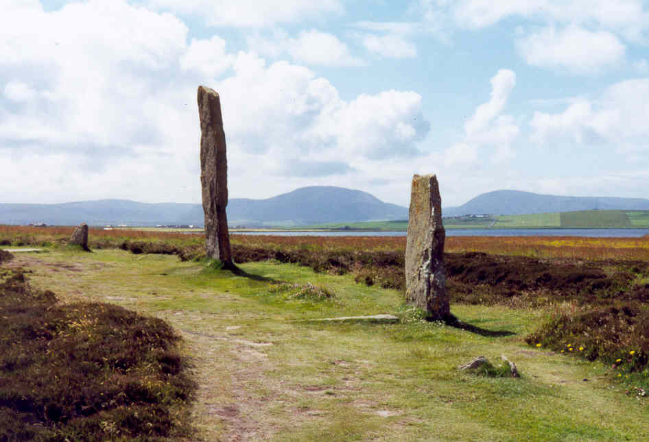
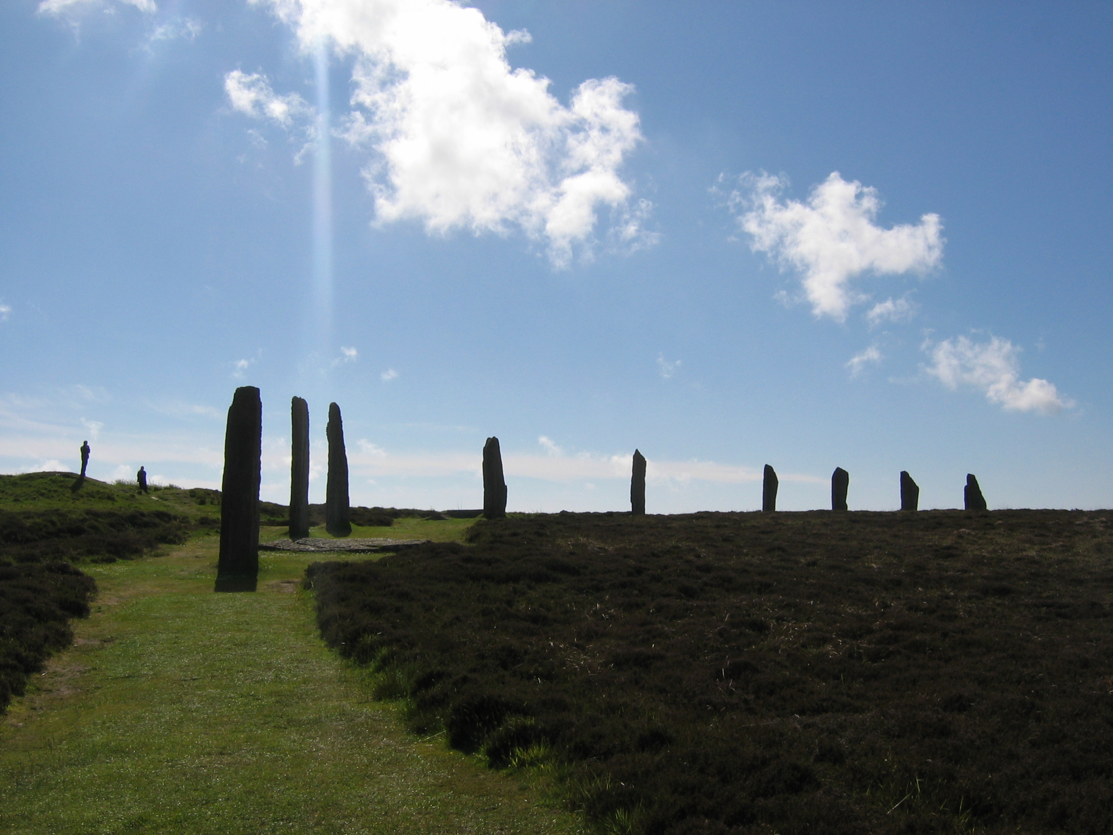
The Ring of Brodgar is a Neolithic stone circle and rock-cut ditch on a narrow isthmus of Mainland in Orkney, between the salt water of the Loch of Stenness and the fresh water of the Loch of Harray. The circle is about 103 to 104 metres across, on a platform of about 100 metres, inside a ditch about 123 metres in diameter. It was laid out for as many as 60 stones. Counts of what remains give 21 stones standing erect, 27 standing in 1929 and at the end of the twentieth century, and 36 surviving, some as tall as 4.7 metres.
One account of the ditch describes circular shafts later joined, with the rock prised out by wooden wedges and no tool marks on the face, while another describes hammerstones, wedges, and antler picks along the natural fissures. The cut was about nine to ten metres wide and more than three metres deep, perhaps near four, with causeways about three metres wide on the north-west and a little over one metre on the south-east. No outer bank has been found, so the spoil likely went into the inner platform. Aubrey Burl classed the monument with enclosures that have two opposed entrances and read circles of this kind as places of rite, tied to death, fertility, and ancestors, rather than as observatories.
Dates for the work do not agree. Luminescence samples taken in 2008 place the digging of the ditch between 2600 and 2400 BC, while the circle as a whole has been set between 2600 and 2000 BC, between 2500 and 2000 BC, and around 2250 BC. If the ditch date holds, the Stones of Stenness, Barnhouse, and the Ness of Brodgar were already standing and visible. Pollen from the fill shows open grassland and cereals, in a landscape whose tree cover was not unlike the present.
The ring comes late in a much older Neolithic. At Aşıklı Höyük in Cappadocia, a settled community lived from about 8200 to 7400 BC, burying the dead under house floors and moving obsidian far across the region. The Goseck Circle in Saxony-Anhalt, a ditched enclosure about seventy-five metres across with solstice gates, was built around 4900 BC. The Almendres Cromlech near Évora began in the sixth millennium BC and was reworked through later Neolithic phases into a large gathering of granite menhirs.
On Orkney the immediate setting was a farming tradition already established in north-west Europe before 4000 BC, which here took monumental form between about 3000 and 2000 BC. Maeshowe, the Stones of Stenness, and Skara Brae stood in the same bowl of land, with the tomb's passage aimed near the midwinter sunset. At the Ness of Brodgar, between the circles, a great stone wall and a dense group of buildings were already part of that world. In 2022 diggers there found a whale vertebra in a post-hole of the earliest house and stone steps built into the wall, finds that belong to the Ness and not to the interior of the ring.
The Brodgar stones come from several kinds of rock, with likely sources at Houton, Staneyhill, and Vestra Fiold, a hill about ten kilometres to the north-west where quarried blocks still lie. Two sockets that were examined were extremely shallow, which may explain the many falls, and it is not known whether all 60 stones were ever raised. The interior has no obvious stones. A note by George Petrie, brought forward in 2025, records that digging in 1861 near several stones and at the centre found no burials, and survey since has still shown no clear structure inside the circle.
At least thirteen burial mounds stand around the ring. In 1854 James Farrer and George Petrie found two cists of cremated bone in Plumcake Mound, and a fragment of that bone dates to between 1745 and 1566 BC, so the place was still used for the dead in the Early Bronze Age. Salt Knowe and Fresh Knowe are large and poorly understood, and Fresh Knowe may be older than the circle. Objects from the ring itself are very few: a flint arrowhead in 1928, a rough stone axe and a hammerstone in 1906, and a quartz hammerstone in the 1970s.
One stone carries the runic name Bjorn and a small cross, and an anvil has been reported, though the authenticity of the writing has been debated. Later legend called the ring a temple of the sun and told of giants frozen at sunrise, with the Comet Stone as a fiddler. Frederick William Leopold Thomas, while drawing an Admiralty chart in 1848 and 1849, found no structure in the interior and a surface already stripped of turf and soil.
The earliest known written notice dates to 1529. Walter Scott in 1814 and Hugh Miller in 1846 both reached for Stonehenge and for druids when they described the stones. The circle was scheduled in 1882 and passed into state care in 1906, when most of the fallen stones were raised again. In June 1941 carriers of the 9th Battalion, the Gordon Highlanders, drove between the stones, and in June 1980 lightning felled one of them.
Colin Renfrew cut three narrow trenches in 1973 and could date only later peat in the ditch. In 2008 Jane Downes and Colin Richards reopened those cuttings, showed how the shafts had been dug, and recovered the samples that date the ditch. In 1999 the World Heritage Committee inscribed the Heart of Neolithic Orkney, with the ring beside Maeshowe, Stenness, and Skara Brae, the first archaeological site in Scotland designated for its cultural value. Alexander Thom's lunar geometry and Aubrey Burl's seasonal rites both try to explain the gatherings, and the centre of the circle is still almost empty of finds.
Images





Detailed History
The Ring of Brodgar, also spelled Brogar and sometimes Ring o' Brodgar, is a Neolithic stone circle and rock-cut enclosure on Mainland, the largest island of Orkney. It stands on a narrow isthmus between two lochs, about ten kilometres, or six miles, north-east of Stromness. The Loch of Stenness, to the south, is salt water. The Loch of Harray, to the north, is fresh.
The stones occupy a slight rise inside a natural bowl of hills, with wide views over water and farmland, and they are meant to be seen against the sky. The form without the letter d is the one that matches a supposed Old Norse etymology, bridge farm, but both spellings are used, and the form with the d is the one kept for the monument in state care.
This is one of the densest surviving prehistoric landscapes in Britain. Within a few square kilometres stand the Stones of Stenness, the chambered tomb of Maeshowe, the settlement and ceremonial complex at the Ness of Brodgar, the outlying Comet Stone, the Barnhouse Stone, the Watch Stone, and a scatter of mounds, cairns, and single stones. The ring is intervisible with Maeshowe, the Stones of Stenness, the Barnhouse Stone, the Watch Stone, and the Knowe of Unstan. A further henge, the Ring of Bookan, lies to the north-west.
The monuments on the Brodgar and Stenness peninsulas were placed inside a vast topographic bowl whose ridgelines run from Hoy to Greeny Hill and back, and they remain visually tied to other tombs and stones around the lochs. The open, lightly developed ground still lets a visitor see those relationships. A public road now cuts the monument in two. Only the main area on the west side of the road is enclosed, and people entering are directed toward the northern causeway.
The circle of stones is about 103 metres across in one account and 104 metres in another, standing on a platform of about 100 metres. The surrounding ditch is about 123 metres in diameter from its outer edge. One account calls the ring the third largest stone circle in the British Isles, and another calls it the largest stone circle in Scotland. As a henge monument it has been ranked among the largest in Britain, surpassed only by Avebury and the Great Circle at Stanton Drew, and it has also been described as once among the largest stone circles in Europe.
The stones form a near-perfect circle, and the ring has been called the only major henge and stone circle in Britain that is almost truly circular. The tallest stones stand on the south and west, and some reach 4.7 metres. They are set fairly regularly, though they stand closer together beside the causeways. Unlike Avebury, there are no obvious stones inside the circle.
The interior has never been fully excavated to modern standards, so timber settings or other slight features are not ruled out, but nothing substantial shows on the surface.
The ditch was cut into solid sandstone. It is about nine metres wide in one description and about ten metres in another, and its circumference has been given as 380 metres. Its original depth is given both as up to or over three metres and as around four metres. Two narrow opposed causeways cross it, one on the north-west about three metres wide and one on the south-east a little over one metre wide.
Aubrey Burl classed this ditch with henges that have two opposed entrances. In a strict sense it is not a typical henge, because a henge is usually a ritual enclosure defined by a ditch and an external bank, and no bank has been found here in either modern excavation. The spoil was likely used to form the internal platform. When the ditch was fresh it would have been a severe obstacle, and it has been suggested that a water-filled cut, on an isthmus between a salt loch and a fresh one, echoed the experience of living in an island world.
The ditch was not taken out as one continuous trench. Excavation shows that it was dug in discrete segments. One account, from the reopening of the ditch in 2008, says the builders sank a series of circular shafts and later joined them, that the rock face carries no tool marks, and that the stone was probably prised out with wooden wedges. Another account says the bedrock was fractured along its natural fissures with hammerstones, wedges, and antler picks.
Both can be read as ways of working a jointed sandstone, and the sources do not reconcile the tool kit. The segmented work has prompted the suggestion that separate gangs, perhaps from different parts of Orkney, dug different lengths. Two stone sockets that were examined were extremely shallow. If the others are like them, that shallowness helps explain how many stones fell, and it may mean that permanence was not the builders' first concern.
The number of stones is told in several counts that should be kept apart. The plan is thought to have allowed for sixty monoliths, but it is not known whether all sixty were ever raised. A monument of this kind has a long life, and the ring as it stands is only its latest form. Twenty-one stones are described as standing erect in a recent assessment of the monument.
Twenty-seven were standing by 1929, and twenty-seven are also said to have been standing at the end of the twentieth century. Thirty-six are said to survive today, a figure that can include fallen stones and stumps as well as those still upright. Some are lost. Others survive as packing or as broken stumps, and others lie where they fell or were pushed.
A number were put back up in the early twentieth century. The rest have stood through the centuries.
The stones are not one rock. As many as seven different lithologies may be present. Three probable sources have been identified, at Houton, at Staneyhill, and at Vestra Fiold, a hill about ten kilometres to the north-west that can be seen from the ring, where quarried monoliths still lie. It has been suggested that stones brought from different places in Orkney stood for different social groups.
How they were moved and set up is still poorly understood. To the south-east of the ring, the Comet Stone stands alone at about 1.75 metres, with two neighbouring stumps, and it may once have belonged to a larger setting on the isthmus.
The age of the monument has been hard to fix, and the published figures do not agree. Samples taken in 2008 for optically stimulated luminescence date the digging of the ditch to between 2600 and 2400 BC. The stones may have gone up at a different time. The circle as a whole has been placed between 2600 and 2000 BC, between 2500 and 2000 BC, and around 2250 BC.
It has been called the last of the great Neolithic monuments on this neck of land. If the ditch date is right, the Stones of Stenness, the settlement at Barnhouse, and the Ness of Brodgar were already present and visible when the ditch was cut. Pollen from the ditch fill suggests that in the early third millennium BC the immediate ground was open grassland, with a tree cover not unlike today's, and that cereals were growing somewhere near enough for their pollen to settle in the fill. The monument, on that evidence, was built in a cleared farming landscape rather than in wildwood.
That farming world had a much older ancestry, and the ring should not be collapsed into it. At Aşıklı Höyük, a settlement mound on the bank of the Melendiz in Cappadocia, about twenty-five kilometres south-east of Aksaray, people were living a settled life from about 8200 to 7400 BC. The mound was first noted by Ian Todd in 1964, and Ufuk Esin began salvage excavations in 1989 as the waters of a nearby lake were due to rise. It is one of the earliest aceramic Neolithic sites on the Anatolian plateau, a first substantial experiment in staying in one place.
Obsidian from the region travelled as far as Cyprus and Iraq. The dead, fewer than seventy people after hundreds of rooms had been opened, were buried in pits cut through the floors of houses still in use. Women in the skeletal sample often died between twenty and twenty-five, with spines marked by heavy loads, while some men lived past fifty. None of this is an Orkney story.
It is the deep background of village life, several thousand years before anyone quarried the Brodgar ditch.
Circular enclosures are old as well. The Goseck Circle, on farmland in Saxony-Anhalt between Naumburg and Weißenfels, was built around 4900 BC and seems to have stayed in use until around 4700 BC. Otto Braasch saw it in 1991 as cropmarks on an aerial photograph. François Bertemes and Peter Biehl opened a major excavation in 2002.
The ditch is about seventy-five metres across and was once up to 1.8 metres deep, with the spoil thrown up as an outer rampart and two rings of palisade inside. Three main entrances face north, south-west, and south-east, and the southern gates align with sunrise and sunset at the winter solstice, with smaller gaps toward the summer solstice. The state archaeologists present it as a ritual or cult structure. Marketing has called it a solar observatory, but the solstices are the only clear astronomical alignments in the remains.
Animal and human bone, traces of fire, and a headless skeleton near the south-eastern gate have been read as evidence of rite, perhaps even of sacrifice. The wooden circle was rebuilt for visitors and opened on the winter solstice of 2005. It belongs to the stroke-ornamented pottery horizon of central Europe, not to Orkney, and nothing in the Brodgar record claims it as an ancestor.
In Iberia, the Almendres Cromlech stands in the Alentejo, west of Évora, and is the largest existing group of structured menhirs in the peninsula. Henrique Leonor Pina found it in 1966 while working on geological maps. Its building runs from the sixth millennium BC through phases around 6000, 5000, and 4000 BC, from early and middle Neolithic into a late Neolithic reworking, and the sequence reaches the Chalcolithic. About ninety-five granite monoliths are set in circles and ellipses over an area of roughly seventy by forty metres, aligned north-west to south-east, with many of the stones raised again in modern times from their original sockets.
The older stones form tighter circles on the west. Later work produced larger menhirs and two irregular ellipses, and the late phase seems to have turned the place toward social or religious rites. It has been read as a ceremonial enclosure or as a rough astronomical observatory, with orientations compared to the equinox and, at the latitude, to an extreme of the moon. Decoration survives on some weathered faces.
As with Goseck, the honest use of this comparison is chronological. These are earlier gatherings of stone and ditch. The Ring of Brodgar comes late in that wider human habit, and on a different sea.
What led to the Orkney ring was the Neolithic of the north itself. The Heart of Neolithic Orkney is characteristic of the farming culture already established in north-west Europe before 4000 BC, and the local tradition of house, tomb, and ceremony flourished between about 3000 and 2000 BC. The four principal monuments, the ring, the Stones of Stenness, Maeshowe, and Skara Brae, preserve domestic, funerary, and ceremonial practice with unusual completeness. Maeshowe is a large chambered tomb whose passage points close to midwinter sunset.
Stenness is an ellipse of standing stones, of which four substantial stones survive, inside a ditch and bank. Skara Brae is a settlement of stone houses linked by narrow roofed passages. Together they show the material skill and the social organisation of communities that also raised Avebury, Stonehenge, the Bend of the Boyne, and Carnac. The stake was not a single building.
It was a landscape in which the living, the dead, and the ceremonies were kept in sight of one another.
The Ness of Brodgar, roughly midway between the ring and the Stones of Stenness, is the clearest sign of how busy that landscape was before and during the life of the circle. Excavation there, underway since 2004, has uncovered a tight complex of buildings, some ritual and some domestic, with pottery, animal bone, stone tools, and a polished stone mace-head. A great stone wall, perhaps a hundred metres long and up to six metres wide, may have crossed the peninsula and has been read as a symbolic barrier between the ritual ground of the ring and the ordinary world beyond it. In 2022, in the first season after the pandemic, a seven-week excavation directed by Nick Card exposed more of that northern wall, including stone steps built into it and described as among the earliest steps in Britain.
Anne Mitchell reported a whale vertebra set on its side in a post-hole of Structure 5, the earliest building on the site, dated to about 3400 BC. The same season produced ornate thumb pots, axe-heads, and stone spatulas peculiar to the Ness, and it opened more of Structure 27, thought to date to about 3000 BC, whose fine walling is still unexplained. Those discoveries belong to the Ness, not to the interior of the ring. They matter here because they show the society already in place when the ditch was cut: a community able to build great walls and elaborate houses, and to innovate, within view of the circle.
Very few objects have ever come from the ring itself. In 1928 a small flint arrowhead was found near the north-west causeway. During remedial work in 1906 James Walls Cursiter found a rough stone axe and a hammerstone. A quartz hammerstone came from the trenches of the 1970s.
The immediate area has also produced flint arrowheads and broken stone mace-heads that seem to belong to the Bronze Age. Many of the monoliths have flaked edges where early visitors knocked off chips as trophies, and a few of those flakes survive in museum collections. Other visitors cut their initials, names, and dates into the stone. The emptiness of the finds is itself a result.
Whatever happened inside the circle left almost no ordinary debris.
The purpose of the ring is still opaque. It is treated as a ceremonial enclosure, but no source can say what rite was performed, or for whom. Alexander Thom, a Scottish engineer who spent decades surveying hundreds of megalithic sites with theodolite and family helpers, argued for a shared prehistoric measure, the megalithic yard, of about 0.8297 metres. He had come to that work after a career in engineering, from Glasgow and the Forth Bridge to the chair of engineering science at Oxford, and from 1933 to 1977 he measured circles across Britain and France, sorting them into true circles, flattened circles, eggs, and ovals.
On his figures the bank diameter at Brodgar is almost exactly 125 of those yards, the same as the inner banks at Avebury and the ring at Newgrange. He and his father also argued that the ring and the mounds around it were designed as backsights for watching the moon. He suggested more widely that some megalithic complexes were built to predict eclipses on a nineteen-year cycle, and that prehistoric Britain kept a solar calendar. Douglas Heggie, looking hard at the statistics, found little evidence for a highly accurate unit and little justification for the claim that one was in use.
Graham Ritchie pointed out that the burial mounds have not been reliably dated, and he doubted the astronomical skill claimed for the builders. The monument has been thought, by a significant group of archaeologists, to preserve an interest in the sky together with the lesser monuments visible from it, but conclusive proof has been very hard to find.
Aubrey Burl approached the same problem from the side of ritual rather than from the side of the observatory. He was a British archaeologist of megaliths, principal lecturer at Hull, and he died in 2020. He was willing to allow that many circles had roles tied to the sky, but he was cautious of the thinner claims of archaeoastronomy. In his reading, circles and henges were less likely to be observatories staffed by astronomer-priests than places of rite connected with death, fertility, and the ancestors, used at turning points of the year such as the spring equinox and the summer solstice, in the manner of other farming cultures.
It is Burl who classed the Brodgar ditch as an enclosure with two opposed entrances, on the north-west and the south-east. His wider caution is part of how this ring has been argued over. The stones may mark a gathering place for a farming people who watched the year. They have not been shown to be instruments.
A further speculation, from Euan MacKie, made the nearby village of Skara Brae the home of a privileged theocratic class of wise men who carried out astronomical and magical ceremonies at Brodgar and Stenness. Graham Ritchie and Anna Ritchie answered that there is no archaeological evidence for that claim. There is, however, a Neolithic low road that links Skara Brae with Maeshowe and passes near both circles, one of the low roads that join ceremonial places across Britain. A path is not a priesthood.
The political shape of Neolithic Orkney, if that word can be used, has to be inferred from labour and from layout: the capacity to quarry, haul, and raise, the choice to put houses, a tomb, and two great circles within one bowl of land, and the decision to keep working on that bowl for centuries. Who commanded the work, and whether the gangs on the ditch represented different districts, remains a suggestion rather than a demonstrated constitution.
Around the ring are at least thirteen prehistoric burial mounds and a stone setting. Some of the mounds may be older than the circle and may help explain why this isthmus was chosen. Others show that the place remained a focus for the dead after the Neolithic. Plumcake Mound, named for its shape, was opened by James Farrer and George Petrie in 1854.
They found two stone cists, each with cremated human bone, one inside a decorated steatite urn and the other inside a pottery urn. It is not clear whether those burials were secondary. A single piece of calcined bone gave a date of 1745 to 1566 BC, so the mound was in use in the Early Bronze Age. Salt Knowe, about forty metres across and six metres high, is on the scale of Maeshowe and takes its name from the salt water of Stenness, just as Fresh Knowe, close to the fresh water of Harray, takes its name from that loch.
Antiquarian digging and recent geophysical survey have found no internal structure in Salt Knowe, so both its date and its function are unknown. In 1853 Farrer cut a single trench across the north end of Fresh Knowe, reported no finds, and yet the mound was seen to have been carefully built. Its size and elliptical plan have been taken to suggest a Neolithic burial mound raised before the ring. Most of the other mounds were poked at without a system, and little was written down.
The centre of the circle is a separate problem, and a recent piece of archive work has changed the way that problem is told. For many years the interior was described as never excavated, and a modern assessment could still say that no excavation had been recorded there. Geophysical survey, hampered by the local geology, has detected only hints of anomalies and nothing conclusive. Turf-stripping in the nineteenth century may have destroyed shallow evidence.
In March 2025 an unpublished note by George Petrie, the Kirkwall antiquary who lived from 1818 to 1875, was brought back into view. Petrie wrote that the area inside the stones has a rough, uneven surface, has never been levelled, and shows no trace of a mound or a terraced platform. He added that excavations were made in 1861 in the neighbourhood of several of the stones and in the centre, in the hope of finding burials, and that none were found. The note does not name the diggers.
The circumstances point to James Farrer, a member of parliament and an energetic antiquary whose methods were later called unmethodical and scandalously casual, very likely with Petrie beside him or close behind him.
Farrer had wanted, from a visit in 1860, to open the larger tumuli near the circle. John Stuart, secretary of the Society of Antiquaries of Scotland, pressed him to examine the great circle and the mounds around it more thoroughly. Farrer returned in the summer of 1861, but his attention had shifted to Maeshowe. He put some days into sites near Stenness, then started on Maeshowe because he expected distinguished visitors from Edinburgh and Aberdeen and thought a couple of days would open the mound.
Once Joseph Robertson saw the first runic inscriptions inside Maeshowe, the other work was dropped. A six-day dig at the Bookan cairn ended, and the cuttings at Salt Knowe and Fresh Knowe, and perhaps at the ring, were abandoned. On 27 July 1861 Farrer wrote to a local newspaper that he would not continue, for the present, the excavation of the two great tumuli east and west of the ring, hoping that the Maeshowe runes might throw light on them later. Petrie often recorded what Farrer left unpublished.
At Fresh Knowe he disagreed with the claim that nothing had been found, insisting that the mound was too carefully built to be a heap of rubbish. His note on the ring is brief, and it agrees with the empty result. The rediscovery does not fill the centre with a lost temple. It shows that someone looked, briefly, for graves, and did not find them.
It also shows why a later statement could still say the centre was unexcavated: the dig was never properly published.
The same mid-nineteenth-century generation produced the first measured plan. Captain F. W. L.
Thomas, Frederick William Leopold Thomas, was a Royal Navy surveyor, the son of a naval master, who had served in Investigator and Mastiff under his father, took command of the cutter Woodlark as a lieutenant in 1841, and later rose to commander and then to captain on retirement. His hydrographic work was mostly in Scottish waters and produced charts and sailing directions. While he was in Orkney from 1848 to 1849, drawing up an Admiralty Chart, he and his crew surveyed the antiquities as well as the coasts. An Admiralty Chart, in that tradition, was a navigational sheet issued for the safety of ships, compiled by the Hydrographic Office that had been founded in 1795, and Thomas's Orkney sheets belong to that official mapping of the north.
Out of the same seasons came his account of the Celtic antiquities of Orkney, including Stenness, the mounds, and the Picts' houses, with plans. The survey is dated to those years, the paper has been cited as 1851, and the publication has also been placed in 1852. It was the first detailed survey of the monuments around Stenness.
Thomas saw no structure inside the ring, and he saw that the ground had not been smoothed or levelled. He also recorded the damage. Peat and turf had been cut for fuel, and every layer of soil had been lifted, as fast as it formed, to manure the infield. The paring of the outfield, he wrote, gave the country a barren look that was not natural, and the ring had been given no sanctuary by the people who stripped it.
That observation matters twice. It explains the scarred surface Petrie and later archaeologists inherited, and it warns that slight traces in the centre could have been carted away as turf and soil long before any scientific trench. It does not prove that a large structure once stood there and vanished. Thomas himself saw no such structure, and centuries of disturbance are more likely to have erased small, temporary features than a stone setting on the scale of the circle.
Later stories gathered on top of this emptiness. Invaders from Scandinavia had reached Orkney by the ninth century. At least one stone at the ring carries a Norse runic inscription, the name Bjorn, together with a small cross, and an anvil has also been reported. A second reported inscription is no longer visible.
There has been debate over whether the runes are genuine. Local legend, or the antiquaries who collected it, called the ring the temple of the sun and the Stones of Stenness the temple of the moon. Young people were said to make their vows and to pray to Woden at those temples and at the Odin Stone, which stood between the circles until a farmer destroyed it in 1814. That reading has been challenged as a romantic addition of the eighteenth or nineteenth century, of a piece with labels such as a druid's circle or a sacrificial altar, rather than as a memory of Norse rite at the stones.
A folk story explained the ring as a dance of giants, frozen into stone when the sun rose, and cast the Comet Stone as the fiddler. People were said to take off their hats when they walked past that outlying stone. These tales show how the monument lived in later imagination. They are not evidence for the Neolithic builders, and they are not evidence that a Viking cult was installed in the circle.
The runes, if they are accepted, are the firmer Norse trace: someone who knew runic writing stood at the stone and cut a name.
The written record of the ring, as opposed to the legend, begins early for a British prehistoric monument. The first known account dates to 1529, and both prose and drawings survive from the antiquarian centuries, including views made before some of the stones were re-erected. In 1814 Walter Scott wrote of the ring and the Stones of Stenness that Stonehenge excels these monuments, but that he fancied they were otherwise unparalleled in Britain. In 1846 the geologist Hugh Miller said the stones look like an assemblage of ancient druids, mysteriously stern and invincibly shaggy and silent.
Those sentences are the nineteenth century looking at a ruin and reaching for druids and for Stonehenge. They are useful because they fix an early modern impression, not because the builders were druids.
The path into public care is clearer. The ring was scheduled on 18 August 1882, under the official name Ring of Brogar stone circle, and it was one of the first sites placed on that original list in the British Isles. In 1906 it passed into state care. Most of the fallen stones were raised again at that time, in remedial work that continued to 1908.
Several had been deliberately knocked down in the early nineteenth century. By 1929, twenty-seven stones were standing. The area in guardianship was extended in 1966. The land had belonged to the Balfours of Trenabie.
John Balfour, who lived from 1750 to 1842, made a large fortune in the service of the East India Company in southern India, returned to Britain in 1790, and is thought to have doubled that fortune after his return. On his death the bulk of his 180,852 pounds passed to his great-nephew David Balfour, who lived from 1811 to 1887 and spent heavily on agricultural improvement. From the 1870s the estates were divided among the family. David Balfour took a particular interest in Maeshowe, and later generations placed other ancient sites into care.
The passing on of that wealth played a part in the preservation of Orkney's old monuments, including the survival of this one into public ownership.
The twentieth century used the circle in ways the builders could not have imagined. In 1941 the monument was apparently used for tank training. A photograph shows Bren gun carriers of the 9th Battalion, the Gordon Highlanders, passing between the stones on 18 June 1941. Despite that, little further damage is recorded until June 1980, when lightning felled one stone.
At least one other stone has been struck by lightning, and a strike is one possible reason why some monoliths now lie flat. The quality of survival, even after re-erection, is still regarded as outstanding.
Scientific excavation has been remarkably slight for so famous a place. In 1973 Colin Renfrew opened three narrow trenches, two of them across the ditch. Very little was found. The only deposits that could be radiocarbon dated were upper layers of peat, and those returned an Iron Age date, long after the ditch was cut.
In 2008, thirty-five years later, the ring was dug again for a month by a team of fifteen archaeologists and students from the UHI Archaeology Institute, the University of Manchester, the University of Stirling, and the Scottish Universities Environment Research Centre. Jane Downes and Colin Richards, the latter then at Manchester, led the work. They reopened and extended Renfrew's ditch trenches and carried out geophysical survey to look for stone-holes and other features. Bob Nunn of Bournemouth University supervised the northern trench, Trench A.
Antonia Thomas of the UHI Archaeology Institute supervised the southern trench, Trench C. The luminescence samples from that season are what place the ditch between 2600 and 2400 BC, and the sections are what show the joined shafts. An account of the same season identifies the work with ORCA. A diary kept online during the dig was later lost and then gathered and expanded so that the record of those weeks would survive.
The centre was not opened. That restraint, and the thinness of earlier digging, is why fundamental questions remain.
In 1999 the World Heritage Committee inscribed the Heart of Neolithic Orkney. The committee is the body that decides which places are placed on the world heritage list. It is drawn from twenty-one states, it meets in ordinary session once a year, and it is advised by the IUCN, ICOMOS, and ICCROM. The Orkney group was inscribed in 1999, at the committee's twenty-third session, and a minor change to the boundary was inscribed in 2015.
It was the first archaeological site in Scotland designated for its cultural value. The ring sits inside that designation with Maeshowe, the Stones of Stenness, and Skara Brae, and the immediate ground also lies in the Brodgar Rural Conservation Area, the only conservation area in Scotland designated for its archaeological value. The re-erection of fallen stones here and at Stenness in the nineteenth and early twentieth centuries is acknowledged in the assessment of authenticity, but antiquarian drawings show that the monuments remain largely where they were, and the ring is still a dominant feature of a rural landscape. The threats named for the wider group are visitor footfall and coastal erosion.
At the ring itself the pressure is the wear of feet on grass. Sections of the inner path are closed from time to time so that the ground can recover, and people are asked to follow a one-way route, to keep to the paths, and not to climb the mounds. Carving graffiti is forbidden. Entry is free, and the site is open all year.
Strong footwear is recommended because the grass is uneven and the place is exposed. Guided walks have been offered on the history, the wildlife, and the folklore. The surrounding land is managed for grassland, wetland, and breeding birds.
What the ring changed is the evidence for early society in the north. It shows that people here, contemporary with the early centuries of monumental building elsewhere in Europe, could organise a rock-cut ditch on a huge scale and a stone circle of unusual geometric regularity, in a landscape already dense with houses and tombs. It remained a place for the dead into the Early Bronze Age, received at least a Norse name cut into one stone, and then passed through antiquarian measurement, state care, a wartime photograph, and a very small amount of modern excavation. The gaps are still the ones that matter.
It is not known whether the ditch or the stones came first, whether every stone was raised, what stood in the centre, where the missing monoliths went, or what the gatherings were for. Alexander Thom's lunar geometry and Aubrey Burl's seasonal rites are both attempts to answer that last question, and neither has closed it. The stones stand between the salt loch and the fresh loch, on open grass, and the centre is still almost silent.
Sources
- Ring of Brodgar — Wikipedia
- Alexander Thom — Wikipedia
- Aubrey Burl — Wikipedia
- Aşıklı Höyük — Wikipedia
- F. W. L. Thomas — Wikipedia
- Goseck Circle — Wikipedia
- World Heritage Committee — Wikipedia
- Admiralty Chart — Wikipedia
- Almendres Cromlech — Wikipedia
- Heart of Neolithic Orkney — UNESCO World Heritage Centre
- Ring of Brodgar Statement of Significance — Historic Environment Scotland
- Plan your visit: Ring of Brodgar Stone Circle and Henge — Historic Environment Scotland
- Ring of Brodgar Stone Circle and Henge — Historic Environment Scotland
- Ring of Brodgar — Working Stone
- The 2008 Ring of Brodgar excavations — UHI Archaeology Institute
- Fruitless and forgotten: the 1861 excavation inside the Ring of Brodgar — Ness of Brodgar Project
- New discoveries at Orkney's Ness of Brodgar Neolithic site — BBC
- RingofBrodgarJM.jpg — Wikimedia Commons
- Ring of Brodgar20061217.jpg — Wikimedia Commons
- Ring of Brodgar - Orkney.jpg — Wikimedia Commons
- Brogar31.jpg — Wikimedia Commons
- BrogarRing10.JPG — Wikimedia Commons
- Brodgar woodcut.jpg — Wikimedia Commons
- Comet Stone and Ring of Brodgar 20061217.jpg — Wikimedia Commons
- Bren gun carriers of the 9th Battalion, Gordon Highlanders pass between the prehistoric standing stones of the Ring of Brodgar on Orkney, 18 June 1941. H10589.jpg — Wikimedia Commons
- Brodgar excavations (geograph 4125917).jpg — Wikimedia Commons
- Brodgar.jpg — Wikimedia Commons