
Monument
Mor Stein
neolithic standing stone in southeast Shapinsay, Orkney Islands, Scotland, UK

Orkney Islands, United Kingdom · United Kingdom
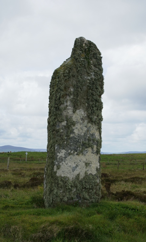
- Mor Stein, also called the Standing Stone of Shapinsay and known locally as the Moora Stone, is a solitary unshaped pillar in the south-east of Shapinsay in the Orkney Islands.
- A published height is about 3.2 metres, or 10 feet, while an older parish account remembered 12 feet above the ground, before a fall a few years before 1928 took part of the top.
- It is called Neolithic and is classed as a prehistoric ritual and funerary standing stone, with an island account that it has stood for almost 5,000 years.
- Linton Bay lies slightly to the north-east, Burroughston Broch stands a few miles north, and the stone was scheduled on 10 November 1953.
History
Mor Stein is a solitary unshaped standing stone in the south-east of Shapinsay, in the Orkney Islands. It is also called the Standing Stone of Shapinsay, and on the island it is known as the Moora Stone. One published height is about 3.2 metres, or 10 feet. An older parish description remembered 12 feet above the ground, with perhaps 5 or 6 feet more below the surface, a breadth between 4 and 5 feet, and a thickness of a foot and a half.
A few years before 1928 the pillar was overthrown and set up again, losing a portion of its upper part, and an island account places that injury in the 1920s, with a jagged edge where the stone was damaged. It is called Neolithic and is classed as a prehistoric ritual and funerary standing stone, with a claim that it has stood for almost 5,000 years, set beside the stones at Stenness. No laboratory date for this pillar, and no grave from its socket, is given with those statements.
Linton Bay lies slightly to the north-east. Burroughston Broch, an Iron Age tower opened around 1862, stands a few miles to the north. The Ouse is a tidal estuary in the north of the same island, and it is not part of the monument. A wooden piece described as a yoke for oxen came from peat a short way to the south-east, under 6 feet in one account and 4 feet in another.
The stone was added to the schedule of monuments on 10 November 1953, in the parish of Shapinsay. The record does not set out a ticket, an hour of opening, a rule of dress, or a rule of entry. What remains in the field is one repaired pillar, with a Norse-looking name and two local stories of a giant, standing beside farmland divided into square fields in the nineteenth century.
Images




Detailed History
Mor Stein is a solitary standing stone in the south-east of Shapinsay, one of the Orkney Islands. It is also called the Standing Stone of Shapinsay, and in an older spelling the Standing Stone of Shapinshay. People on the island call it the Moora Stone. It stands in a field, unshaped and uncarved, somewhat apart from the other man-made features of the island.
A published height is about 3.2 metres, or 10 feet. An island account of 14 May 2021 gives the same approximate height of 10 feet and describes a lichen-covered surface.
An older parish description remembered a taller stone. Above the ground it was 12 feet high, and the writer guessed that perhaps 5 or 6 feet more stood below the surface. Its breadth was between 4 and 5 feet, and its thickness a foot and a half. Moss, or a scurf of growth, clothed it, and the writer thought it had weathered many ages.
In form and dimensions it was said to resemble stones standing in other islands, and in particular the circle and the semicircle in the parish of Stenness. A notice at the stone names the Reverend George Barry as the writer who called it the Standing Stone of Shapinsay when that greater height was still there. The same parish description, in a printing of 1845, turns from the upright stone to a different one.
The stone did not keep that full height. An inventory of ancient monuments places it on a small patch of unimproved moorland near the highest point in the south-east of the island. A few years before 1928 it was overthrown and re-erected, and it lost a portion of its upper part in the process. The island account puts the same injury in the 1920s: the stone was toppled and then set up again, and a jagged edge shows where it was damaged.
Those two accounts agree on a fall and a repair in that decade. They do not say who pulled it down, or whether the fall was deliberate. The farms of the Balfour estate on Shapinsay were sold between 1924 and 1928, the same years, but that sale is not described as the cause of the fall.
No laboratory date for the raising of this particular stone is given with these measurements. The stone is called Neolithic. The designation classes it as a prehistoric ritual and funerary standing stone. The island account says it has been in place for almost 5,000 years, and sets that span beside the Standing Stones of Stenness.
The class “ritual and funerary” is the label of the monument type. These accounts do not describe a grave found in the socket, or an offering taken from the foot of the pillar.
The published points do not all coincide. The designation gives the national grid HY 52395 16857, with coordinates 352395 and 1016857, a latitude of 59.03607 and a longitude of 2.83120 degrees west. Another grid published for the standing stone is HY 5240 1685. A map coordinate printed with the general account of the stone is 59 degrees 2 minutes 12 seconds north and 2 degrees 49 minutes 47 seconds west.
The differences are small, and they belong to different surveys rather than to two stones.
Linton Bay lies slightly to the north-east of Mor Stein. The bay is on the east coast of Shapinsay. The headland called the Ness of Ork is to the north of Linton Bay, and The Foot is to the south. Burroughston Broch stands slightly north of the bay, and the account of the stone places that broch a few miles to the north of the pillar.
From the broch, Linton Bay lies slightly to the south. The broch overlooks the North Sea at the north-east corner of the island, about four miles from the ferry pier, at the foot of a gently sloping field just above a low rocky shore. Its grid is HY 5406 2100.
The Ouse is a separate water, a tidal estuary in northern Shapinsay. Early maps show it in a shape close to the one it has now. Small rivulets and upland springs feed it from the western side of the island’s north-east spur, and the water of those springs is moderately alkaline, with a pH of 9.1. On Shapinsay the narrow necks of land that shut a strip of sea from the ocean are called ayres.
The same process is described at Vasa Loch, at Lairo Water, and as nearly complete at The Ouse. None of that water is the standing stone.
Shapinsay itself is low and fertile. One account calls it one of the two large inner islands of the group and places it about two miles north of the Orkney Mainland. Its area is given as 29.5 square kilometres, or 11.4 square miles, and also as 2,948 hectares, or 11 square miles. It is the eighth largest island in the Orkney group and the twenty-ninth largest Scottish island.
Ward Hill, the highest point, is 64 metres, or 210 feet. The east coast is low cliff, with sea caves, including the Geo of Ork at the northern tip. Elwick Bay, on the south, is a sheltered anchorage facing the Mainland, and the only village, Balfour, stands at the western end of that bay. At the 2011 census the population was 307.
Most of the land is farmed. From the air the square fields of about ten acres, and the straight roads, are the mark of nineteenth-century improvement.
The bedrock is Old Red Sandstone under boulder clay, the same stone that builds so much of the archipelago. In the long view of Prehistoric Orkney, that sandstone is one reason the old monuments are many: it splits and dresses, the wind-blown sand has buried and kept some sites, ploughing and industry have been lighter than in the south, and a local habit of fear and respect, perhaps carried on from the Norse centuries, may have kept people from pulling structures down. Prehistory, in this northern use of the word, runs until the early historic period of Scotland, around the year 600. The boundaries of the older ages are gradual.
The Paleolithic is taken to the retreat of the ice, the Mesolithic to the start of farming, and the Neolithic to the start of metalworking.
For much of the last glacial period the British-Irish ice sheet covered Orkney, and no archaic human occupation of Scotland is known from the Early or Middle Paleolithic. Late Upper Palaeolithic tools of the Ahrensburgian kind have been found on Stronsay and at Brodgar on the Mainland, and they are read as a human presence around or before 8000 BC, perhaps as early as 11,000 BC, while Britain was still joined to the continent by Doggerland. The first people were mobile hunters who may have come only at times. Rising seas in the early Holocene drowned large parts of the land.
By 8000 BC the land had split into two islands, and by 6000 BC the archipelago looked much as it does now. In the years just after the ice, Orkney is thought to have been heavily wooded, with hazel, birch and willow, and with less birch of another share and Scots pine.
The Mesolithic record north of Inverness, and on Orkney in particular, is thin. Small polished stone tools and chippings come from lithic scatters at Seatter, South Ettit, Wideford Hill, Valdigar and the Loch of Stenness. A charred hazelnut shell from the 2007 excavations at Longhowe in Tankerness is dated 6820 to 6660 BC. Nothing in that list is a house lived in all year, and nothing in it is Mor Stein.
The stone’s own accounts begin with the Neolithic label, not with a Mesolithic tool from its field.
The Neolithic in Scotland is placed from about 4000 to about 2200 BC. Orkney has nearly 3,000 identified Neolithic sites. Archaeologists elsewhere in Britain have often split the age into an earlier phase of regional pottery and building and a later phase of new traditions and larger monuments. In Orkney the change is described as gradual, with later work built on earlier ideas.
The great Orcadian monuments were raised almost a thousand years before the sarsen stones at Stonehenge. For a long time that flowering was treated as a provincial echo of the south. Evidence found more recently is read the other way: styles of building and pottery that appear later in southern Britain have a start in Orkney.
On Papa Westray, which may then have been one land with Westray, the Knap of Howar is probably the oldest preserved house in northern Europe. Two adjacent rounded rectangular buildings, thick-walled, with low doorways and a passage between them, were lived in for 900 years from 3700 BC, on top of a still older settlement. Unstan ware was found there. The houses came to light in the 1920s, when gales and tides stripped that part of the coast.
The Barnhouse Settlement, on the Mainland, is a cluster of at least fifteen buildings, one of them perhaps a place of gathering, occupied between 3200 and 2950 BC. The houses stood above ground, with a central hearth, recessed box beds and stone dressers, and with drains running to a common ditch. Grooved ware, flints, stone tools and three flakes of pitchstone, thought to be from Arran, were found there.
Skara Brae is ten clustered houses, called the most complete Neolithic village in northern Europe, occupied between 3100 and 2500 BC. The houses resemble those at Barnhouse, but passages join them, and they were set into a midden of ash, bone, shell, stone and organic waste. Only the roofs, probably of timber or whalebone, would have shown above that heap. The dressers face the low doors.
Some stones in the houses and passages carry carvings whose meaning is not known. Bone beads, pins and pendants, and four carved stone balls, came from the village. A storm in the winter of 1850 tore the grass from a covering dune and showed the ruins. What is visible is mostly a second phase of building.
These villages and houses are the settled world of the same broad age as the label given to Mor Stein. They are not rooms belonging to the pillar on Shapinsay, and no similar hearth or dresser is described at its foot.
Skara Brae, Maeshowe, the Ring of Brodgar and the Stones of Stenness together form the Heart of Neolithic Orkney, in the west of the Orkney Mainland, inscribed in 1999 as a World Heritage Site. The group sits far from the larger populations of Scotland and of Europe as those places are counted now. The same discussion warns against reading that modern remoteness back into the Neolithic, when smaller islands of the British Isles held an advanced society that took centuries longer to appear on the mainland of Great Britain, and when ideas moved from Orkney as well as toward it. Mor Stein stands on Shapinsay, not in that western Mainland group.
The Standing Stones of Stenness, five miles north-east of Stromness, may be the oldest henge in the British Isles. The name, pronounced stane-is in the local dialect, is from Old Norse for a stone headland. The stones stand on a promontory at the south bank of the stream that joins the Loch of Stenness to the Loch of Harray. The Ring of Brodgar lies about 1.2 kilometres, or three quarters of a mile, to the north-west, and Maeshowe about the same distance to the east.
The ditch and bank are no longer obvious, but excavation showed a henge. The slabs are about 30 centimetres, or 12 inches, thick, with sharp tops. Four of them, up to about 5 metres, or 16 feet, survive from a circle of up to twelve, set in an ellipse about 32 metres, or 105 feet, across, on a levelled platform about 44 metres, or 144 feet, across. The rock-cut ditch is as much as 2 metres, or 6.6 feet, deep and 7 metres, or 23 feet, wide, with an earth bank and a single entrance causeway on the north, facing the Barnhouse Settlement.
The Watch Stone, outside the circle to the north-west, is 5.6 metres, or 18 feet. In the 1930s the stump of a second stone was found there. A square setting in the centre, called a hearth, held cremated bone, charcoal and pottery, and animal bone lay in the ditch. The pottery links the monument to Skara Brae and Maeshowe.
From radiocarbon dating, work is thought to have begun by 3100 BCE.
That circle, not the Shapinsay pillar, carried the later stories of Odin. Couples plighted engagements by holding hands through a hole in the Odin Stone, which stood in the field north of the henge, and other oaths made with a hand in that hole were called the Vow of Odin. Walter Scott visited in 1814. In December 1814 Captain W.
Mackay, a newcomer who farmed nearby, began to smash the Odin Stone because people were crossing his land for the rituals. He destroyed another stone and toppled a third before he was stopped. The toppled stone was set up again in 1906, with some inaccurate reconstruction inside the circle. In the 1970s a dolmen at the site was taken down because its authenticity was doubted, and two upright stones of that setting remain.
The parish writer on Shapinsay used this circle and semicircle only as a likeness for the shape and size of Mor Stein.
Maeshowe, or Maes Howe, is a chambered cairn and passage grave on the Mainland, and it gives its name to a type of tomb limited to Orkney. One account says it was probably built around 2800 BC. The wider prehistoric account dates it from about 3000 BC. Stuart Piggott called it a superlative monument, lifted out of its class by the originality of the work.
The Old Norse name Orkahaugr is in the Orkneyinga saga. Haugr means a mound or a barrow. Orka may be a person or the name of Orkney, so the phrase is read as Ork’s mound or the mound of Orkney. The Scots form Maeshowe keeps howe from that Norse word.
The grass covers passages and chambers. Burroughston Broch was dug shortly after the discovery of Maeshowe, which places the broch excavation in the years around 1862.
Two pottery traditions are part of the same Neolithic landscape, and they are not pots from Mor Stein. Unstan ware sits with small settlements such as the Knap of Howar and with stalled tombs such as Midhowe. Grooved ware sits with larger settlements such as Skara Brae and Barnhouse, and with tombs of the Maeshowe kind. Tribal difference has been offered as one reading of that split.
The suggestion remains a possibility, not a label stamped on the Shapinsay pillar.
The human figure of that age was found on another island. The Westray Wife, also called the Orkney Venus, is a sandstone carving 4 centimetres, or 1.6 inches, high, from the Links of Noltland on Westray, uncovered in the summer of 2009. It is described as the first Neolithic carving of a human form found in Scotland, and as the earliest depiction of a face found in the United Kingdom. The face has two dots for eyes, heavy brows and an oblong nose, and hatches on the body may be clothing.
Richard Strachan called the find one of astonishing rarity. He also compared the eyes with the eyebrow motif cut in a chambered cairn on the Holm of Papa, and left the likeness open: the cairn marks may be brows and eyes, or a familiar motif reused with another meaning. It is not certain that the figure is female. Marks first read as breasts may be fasteners and cloth.
A second figurine, about the same size, of clay and missing its head, was found at the Links in the summer of 2010. It is 3.4 centimetres, or 1.3 inches, high, with a rectangular panel of triangles on the torso, perhaps a tunic, and a punched hole in the stomach. Small clay balls from the site may have been meant as heads. A third figurine was found in 2012.
The first figure was shown at the Westray Heritage Centre in Pierowall in the summer of 2010, and a local baker sold shortbread copies. Some businesses on the island reported a 45 per cent rise in turnover after the discovery. The settlement itself runs from about 3300 BC to 800 BC, with more than thirty buildings of late Neolithic and Bronze Age date under the dunes south of the Bay of Grobust. Digs from 1978 to 1981 found middens, walls and field boundaries, a hearth and red deer skeletons, and a building that survived to the roof, with rooms joined by passages.
In 2009 a large building called a village hall was uncovered, about 20 metres, or 66 feet, wide, with walls 3 metres, or 9.8 feet, thick. In 2015 a buried Bronze Age structure was read as a sweat house or a sauna. The dunes are eroding. The site was scheduled in 1993.
None of these objects was found at Mor Stein.
The Holm of Papa, also the Holm of Papay or the Papay Holm, is a very small uninhabited island of about 21 hectares, or 52 acres, less than a hundred metres west of Papa Westray. Its main sight is the Southcairn, a stalled chambered cairn about 20 metres long, dated approximately to 3000 BC, built of local stone, once a communal place for the bones of a community. A modern roof protects it, and the way in is a trapdoor. It is possible that the people of the Knap of Howar buried their dead here.
Three chambered cairns stand on the holm. Joseph Anderson noted that the Orkneyinga saga speaks of the two Papeys, the great and the little, Papey Meiri and Papey Minni, now Papa Westray and Papa Stronsay.
The Dwarfie Stane is the other great single stone of these islands, and it is not a standing pillar. It is a chambered tomb cut into a block of Devonian Old Red Sandstone, a glacial erratic in a steep glaciated valley between Quoys and Rackwick on Hoy, in desolate peat. It is the only chambered tomb in Orkney cut from the rock rather than built of stones, and it may be the only Neolithic rock-cut tomb in Britain. Its plan still fits the Orkney-Cromarty class, which some writers call Bookan after a cairn on the Mainland, though the two types are not agreed to be the same.
A slab that once blocked the west entrance now lies in front of it. The block is 8.6 metres, or 28 feet, long, 4 metres, or 13 feet, wide, and up to 2.5 metres, or 8.2 feet, high. The entrance is a metre square. Inside, a passage 2.2 metres, or 7.2 feet, long opens into two side cells, each 1.7 metres by 1 metre, or 5.6 by 3.3 feet, and a metre high.
The southern cell has a pillow of uncut rock. The tomb was robbed through a hole in the roof. The hole was already noted in the sixteenth century, and it was repaired with concrete in the 1950s or the 1960s. The name comes from a legend that a dwarf called Trollid lived there, and the tomb has also been claimed as the work of giants.
Walter Scott’s novel The Pirate, published in 1821, made the stone widely known. Graffiti of the eighteenth and nineteenth centuries mark the rock. Captain William Mounsey camped there in 1850 and cut a Persian line, “I have sat two nights and so learnt patience,” with his name written backwards in Latin above it. Hugh Miller, a stonemason as well as a writer, called the sandstone extremely compact.
The idea of a rock-cut tomb has been described as tried once and found unsatisfactory, perhaps because of that hardness, and no direct link is known to the rock-cut tombs of the Mediterranean.
Burroughston Broch is the Iron Age neighbour of Mor Stein, a few miles north, and it is a different kind of building. A broch is an Iron Age drystone hollow-walled roundhouse of Atlantic Scotland, one of the class later called the complex Atlantic roundhouse. The word comes from the Lowland Scots brough, meaning a fort, and nineteenth-century antiquaries used burg, from the Old Norse borg. In the west such buildings are often called dùns.
About 571 candidate broch sites are counted in the country. The densest groups are in Caithness, Sutherland and the Northern Isles, with a few outliers farther south. Mid-twentieth-century opinion often cast them as the work of chieftains pushed up from the south. The hollow-walled tower is now read as a development in what is now Scotland.
The first may have been built around 300 BC, and a defensive or offensive use is part of the evidence. Older readers called them the work of Danes or of Picts, and from the 1930s to the 1960s they were often treated as the strongholds of local landowners. The Iron Age in Orkney is the age that returned to large building after a Bronze Age poor in monuments. That sequence dates the broch tradition.
It does not date the standing stone.
The walls of Burroughston Broch are up to four metres thick in places. The external diameter is about 18 metres and the internal diameter about 10 metres. From outside, the building is a grassy mound, and little of the outer wall is exposed. It is one of the best preserved brochs in Orkney.
The entrance is on the east, about 4 metres long, 1.2 metres wide and 1.8 metres high, with an elongated guard room opening from the left of the passage. Inside, the outer face of an upper gallery can still be seen, and so can traces of an opening into that gallery. A deep well in the floor is dry-stone in its upper part and cut into the rock below. Turf covers traces of outbuildings in the slope before the entrance.
A wall, a ditch and a rampart, which probably once circled the broch, are still evident. A complete chamber survives off the entrance passage, and some stone fittings remain in the interior.
The broch was excavated around 1862 by the estate workers of Colonel D. Balfour, under the direction of the antiquarian George Petrie, shortly after the discovery of Maeshowe. Petrie made notes. Sir Henry Dryden drew a plan.
The dig was limited to the interior and to a small area just outside the entrance. Little is known of the finds. Petrie said they were mostly fragments of deer horn, many bones of ox and sheep, and several rude stone vessels of different sizes, including a possible triangular lamp. The earth cladding is still in place, so that a visitor can look down into the broch from above.
The same Balfour generation touches a find near the stone, and the find is not the stone. David Balfour of Trenaby gave a portion of a tree branch, described by him as a yoke for oxen. It is 2 feet 10 inches long and 4 to 5 inches in diameter, with a rounded hole at each end, the holes apparently made by fire. He said it was found under 6 feet of peat in the White Moss, a short way south-east of the standing stone of Shapinshay.
A later note of the same object says it was found 4 feet down, and it writes that depth as 1.8 metres, and it says the piece was given in 1886. The gift he is credited with is also placed in 1866. The White Moss is a name otherwise unrecorded. A field visit on 2 October 1972 could not find the moss.
The object is classed as a possible Bronze Age wooden yoke. Its grid is given only to about a hundred metres, at HY 523 168. It came from peat to the south-east of the pillar, not from a socket under Mor Stein.
The parish description that measures the standing stone also describes the Black Stone of Odin, and it keeps the two apart. Toward the north side of the island, by the sea, that other stone rests its huge side on the sand and lifts its back above the surrounding stones. It seemed of a different quality. How it came there, what it was for, and what relation it had to the Scandinavian god whose name it carried, the writer said, were matters on which both history and tradition were silent.
A survey of the monuments the Norse found on their arrival distinguished isolated upright stones on Shapinsay, Sanday, Eday and South Ronaldsay from a black stone of Odin on Shapinsay, which seemed to that writer the remains of a dolmen. The upright stone and the black stone are not collapsed into one monument in either account. The Odin Stone at Stenness, with its hole and its vow, is a third stone again, on the Mainland, and it was destroyed in 1814.
Local legend explains Mor Stein itself with a giant. One telling, written down for the island in 2021, says a giant on Stronsay threw the stone, possibly while fighting a giant of Shapinsay. Another telling says a giant threw it at his fleeing wife. The two stories do not name the same quarrel.
Stronsay, the island of the first giant, is known as the island of bays: St Catherine’s Bay to the west, the Bay of Holland to the south and Mill Bay to the east, separated by two isthmuses. It covers 3,275 hectares, or 13 square miles, and rises to 44 metres, or 144 feet. About 320 people usually live there, and the main village is Whitehall. Like most of Orkney it is Old Red Sandstone and mostly low.
The Vat of Kirbister, a natural arch on the eastern coast, is called the finest in Orkney. The giant who throws the stone is a legend attached to that island, not a person recorded in its settlement history.
A visitor has also suggested that, from the mound at Howe, the sun on the longest day rises, as he thought, directly over Mor Stein, and that the stone may have been quarried some distance south-east of Castle Bloody. He marked the thought as his own. It is not a measured alignment, and the quarry is not an opened pit described by an excavation. Another visitor, looking near a wartime building on the other side of the field, saw an unmeasured stone about a metre square with another stone under it, and thought it might be an outlier.
That sighting is not a second scheduled pillar.
The name of the whole archipelago has its own history, and it is older than the Norse word steinn. The Orkney Islands lie 10 miles, or 16 kilometres, north of Caithness, with Shetland as the other part of the Northern Isles. About seventy islands make the group, and twenty are inhabited. The Mainland covers 523 square kilometres, or 202 square miles, the sixth largest Scottish island and the tenth largest in the British Isles.
Kirkwall is the largest settlement and the administrative centre. The islands are one of the thirty-two council areas of Scotland, a constituency of the Scottish Parliament, a lieutenancy, and a historic county. The council is Orkney Islands Council. People have likely lived there for at least 10,000 years: terminal Upper Palaeolithic and Mesolithic hunters, then Neolithic and Bronze Age farmers, then Picts in the Iron Age.
The Kingdom of Norway colonised and later annexed Orkney in 875, and Norse settlers followed. In 1472 the Parliament of Scotland took the Earldom of Orkney into the kingdom after a dowry promised to James III of Scotland by the family of his bride, Margaret of Denmark, was not paid.
Pytheas of Massalia, probably sometime between 322 and 285 BC, described Britain as a triangle with a northern tip called Orcas. That tip may have been Dunnet Head, from which Orkney can be seen. In the first century the geographers Ptolemy and Pomponius Mela called the islands Orcades, and so did Tacitus in the year 98, writing that his father-in-law Agricola had discovered and subjugated the Orcades, until then unknown. Mela and Pliny had already mentioned them.
The usual reading of the element orc is a Pictish tribal name, young pig or young boar. Old Irish has Insi Orc, the islands of the young pigs. Welsh has Ynysoedd Erch, and Scottish Gaelic Arcaibh. Another guess derived the name from the Latin orca, a whale.
Bede, in the Ecclesiastical History, calls them Orcades insulae. Norse settlers from the late ninth century heard orc as the Old Norse orkn, a seal, and added eyjar, islands, making Orkneyjar, the seal islands. English later dropped the plural ending. The Historia Norwegiae says Orkney was named for an earl called Orkan.
The Norse called the Mainland Megenland, or Hrossey, Horse Island. Pomona, or Pomonia, comes from a sixteenth-century mistranslation by George Buchanan and has rarely been used as a real local name.
Gnaeus Julius Agricola was born on 13 June in the year 40 and died on 23 August 93. He was consul and governor of Britannia in 77, completed the conquest of what is now Wales and northern England, and led an army to the far north of Scotland, planting forts across much of the lowlands. The emperor Domitian recalled him in 85. Tacitus, his son-in-law, wrote the life that is the main written source for the governorship.
On Shapinsay a local legend says that Agricola landed. In the eighteenth century a croft named Grukalty was renamed Agricola, which is also the Latin for a farmer. Roman coins have been found on the island, with the caution that traders may have brought them. The legend of a landing, the renamed croft, and the coins are three separate facts, and none of them is a fort built beside Mor Stein.
James III of Scotland was criticised in his own time for schemes against Brittany, Guelders and Saintonge, for debasing the coinage, for failing to settle feuds, and for an unpopular English alliance. The same reign is the one in which Scotland reached what is described as its greatest territorial extent, by the acquisition of Orkney and Shetland through his marriage to Margaret of Denmark. Margaret of Denmark, queen of Scotland, lived from 1456 to 1486 and was the daughter of Christian I of Denmark. The parliamentary absorption of the earldom is the event of 1472, tied to the unpaid dowry.
That political change is centuries after any Neolithic raising of the stone, and it is the reason the islands sit in Scotland rather than in Norway.
Shapinsay’s own written name is less obvious than the names of the larger islands. The ending ay is the Old Norse for island. Haswell-Smith suggested hjalpandis-øy, a helpful island, from a good harbour, though harbours are common in the group. The first written form, in 1375, is Scalpandisay, which may mean the judge’s island.
Another suggestion is Hyalpandi’s island, although no person of that name is known there. Blaeu’s atlas of 1654 maps it as Siapansa Oy and lists it in the text as Shapinsa. The atlas calls the harbour at Elwick quite commodious and praises the dwelling of Sound. The estate of Sound, the western part of the island, passed from the Tulloch family to the Buchanan family in 1627.
John Buchanan was a royal servant, and his wife Margaret Hartsyde was from a Kirkwall family. In 1674 Arthur Buchanan built the new house of Sound, 250 metres west of where Balfour Castle now stands. Walter Stewart’s description in the atlas notes that Shapinsay then had one minister.
The Saga of Haakon Haakonsson says that Haakon IV of Norway anchored in Elwick Bay before he sailed south to defeat at the Battle of Largs. That anchorage is the south bay of the island, not the field of the standing stone.
The Balfour family changed the farmland in which the stone now stands. Arthur Buchanan’s granddaughter married James Fea, who supported the Jacobite rising of 1715. Hanoverian troops burned his house. Andrew Ross, Stewart Depute in Orkney for the Earl of Morton, acquired the estate, and his heirs, the Lindsay brothers, sold it in 1782 to Thomas Balfour, who had rented the Bu of Burray.
By 1846 his grandson David Balfour held the whole of Shapinsay. Most of the land was divided into fields of 4 hectares, or 10 acres. Tenants had to enclose and drain, or pay a surcharge on the rent for the estate to do it. In 1846 the arable land was 303 hectares, or 1.17 square miles.
By 1860 it had trebled to more than 890.3 hectares, or 3.44 square miles. New crops and new breeds of cattle and sheep came in. The reforms were called the fountain and origin of improvement in Orkney. At the start of the nineteenth century, 45 per cent of all Orkney, and fully 2,956 acres of Shapinsay, was common land.
Today 624 acres of common remain in the whole of Orkney. The clearance of cottars into a planned village made them estate workers, and the enclosure was controversial. Thomas Balfour had been to the grammar school in Kirkwall, as his father had. Two of his sons went to Harrow.
During David Balfour’s time, church elders who complained that men had been allowed to dance with women at a social event were evicted from the island.
David Balfour asked the Edinburgh architect David Bryce to turn Cliffdale House into Balfour Castle, in the Scottish Baronial style. He also built a porter’s lodge, later the public house called The Gatehouse, a water mill, a school, and a gasworks that worked until the 1920s. The gasworks is a round tower with a corbelled parapet of red brick and carved stones, one of them perhaps taken from Noltland Castle on Westray and inscribed 1725. The fortified look was wanted, so that the village would seem medieval.
Mill Dam, made as the mill’s water supply, is now a nature reserve. Fishing grew beside the new fields. Herring stations spread through Scotland, the fishery began on Stronsay in 1814, and by the middle of the century Shapinsay had fifty herring boats. Cod mattered more when the Napoleonic Wars pushed English boats north.
Local men, who had lined for fish from small boats for centuries, began to trawl, though fishing stayed largely part-time. Beaches on Helliar Holm were used to dry salted herring and cod. When the wars ended, cheaper soda ash from continental Europe collapsed the kelp industry by 1830, and crofters who had lived on that second income had to take more from the land. The square fields a visitor sees around the south-east of the island are this work.
The inventory still found the stone itself on a patch of moor that the improvement had not taken.
The island account of the stone adds the lichen, the solitary stance, and the comparison with Stenness. It does not give a ticket, an hour of opening, a rule of dress, or a rule of entry. The designation of 10 November 1953 adds the stone to the schedule as a monument of the prehistoric ritual and funerary class, in the parish of Shapinsay and the local authority of the Orkney Islands. Certain works, including repairs, need consent.
That is a rule about altering the monument, not a rule about a visitor’s ticket. The legal paper of the designation is the description and the map of the scheduled area. The record has no bibliography of an excavation, and it warns that a scheduled-monument record is not a full archaeological account.
In the twentieth century the island was a strategic place in both world wars, again without a battle recorded at the stone. In 1917 the ship Swiftsure, of 836 tonnes, or 823 long tons, struck a mine 4 kilometres, or 2.5 miles, east of Haco’s Ness and sank in 19 metres, or 62 feet, of water. One life was lost. The wreck was not found until 1997.
In the Second World War, gun batteries were built on Shapinsay. A twin six-pounder emplacement at Galtness Battery, on the coast at Salt Ness, covered the Wide Firth against torpedo boats. Castle Battery worked from 1941 to 1943, and so did an anti-aircraft battery. A wartime building noticed near the stone is not identified as one of those named batteries.
What remains in the field is one repaired pillar. It has been called Neolithic and almost five thousand years old, measured at about 10 feet and at 12 feet above the ground, and described as having lost the top of that taller stone a few years before 1928. It has a Norse-looking name, a local pronunciation, and two giant stories. A wooden yoke from nearby peat, a broch a few miles north, a bay, an estuary, a black stone by the northern sea, and the great monuments of the Mainland all stand in the same wide history.
None of them is a second name for Mor Stein. The socket has not been reported as dug, and the reason the stone was raised is not stated by the measurements, the fall, or the legends.
Sources
- Mor Stein — Wikipedia
- Prehistoric Orkney — Wikipedia
- Shapinsay — Wikipedia
- Burroughston Broch — Wikipedia
- Orkney — Wikipedia
- Standing Stones of Stenness — Wikipedia
- Dwarfie Stane — Wikipedia
- Westray Wife — Wikipedia
- Links of Noltland — Wikipedia
- Holm of Papa — Wikipedia
- Maeshowe — Wikipedia
- Linton Bay — Wikipedia
- The Ouse — Wikipedia
- Stronsay — Wikipedia
- Broch — Wikipedia
- Gnaeus Julius Agricola — Wikipedia
- James III of Scotland — Wikipedia
- Mor Stein or Standing Stone of Shapinsay — Historic Environment Scotland
- Mor Stein — Shapinsay Development Trust
- Donations to the museum, including a wooden piece from near the standing stone of Shapinshay — Society of Antiquaries of Scotland
- Morstein.jpg — Wikimedia Commons
- Standing Stone Shapinsay. Orkney Islands - geograph.org.uk - 885134.jpg — Wikimedia Commons
- Mor Stein 20110527.jpg — Wikimedia Commons
- Mor Stein with interesting patterns in the sky. - geograph.org.uk - 2227474.jpg — Wikimedia Commons
- Standing Stone in Shapinsay - geograph.org.uk - 2579868.jpg — Wikimedia Commons
- Mor Stein - geograph.org.uk - 7582785.jpg — Wikimedia Commons
- Mor Stein - geograph.org.uk - 8026493.jpg — Wikimedia Commons