
Settlement · Monument
Mên-an-Tol
standing stones near the Madron–Morvah road in Cornwall, England, UK

Madron, United Kingdom · United Kingdom
- A holed granite stone stands between two uprights on the moor in Madron, Cornwall, and the Cornish name means the stone of the hole.
- The setting is placed in the late Neolithic or early Bronze Age, and other accounts run from about 2500 BC to 1500 BC or as far as about 1000 BC.
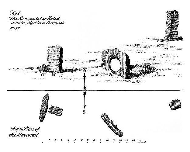
- The stones stood at an angle in 1749, and later plans show a straight line, with the move blamed on the western stone after 1815 or on the holed stone itself.
- A 1992 survey read the group as part of a ruined circle about 17 to 18 metres across, perhaps of 18, 19, or 20 stones.
- Children and people with pain in the back were passed or crawled through the hole, and pins laid on the stone were used to read fortune.
- Repairs in 1992 packed the eroded ground with stone and found nothing of significance, after a trench had produced only a fractured flint.
History
The Mên-an-Tol is a group of granite stones on the moor in Madron, Cornwall, about three miles northwest of the village, on the lower south-eastern slopes of White Downs. The Cornish name means the stone of the hole. A round opening about half a metre across pierces the central slab, and two uprights stand to either side, with more fallen and buried stones around them.
The usual date is the late Neolithic or the early Bronze Age. Other reckonings run from about 2500 BC to about 1500 BC, or as far as about 1000 BC, and a catalogue span reaches from about 2600 or 2200 BC toward 700 BC. No bone, pot, or metal from under the stones has fixed the year. A trench between the stones found only a fractured flint, also called a single flint flake.
In 1749 the three main stones stood at an angle of about 135 degrees. By 1825, or on a plan of 1827, they stood in the line seen today. One account moves the western stone after 1815. Another treats the old plan as inaccurate.
A third moves the holed stone from a little farther south.
Fieldwork in 1992 read the wider scatter as a ruined circle about 17 to 18 metres across, with a suggested ring of 18, 19, or 20 stones. The holed stone is placed on the southern edge in that survey, and a shorter account of the same research also allows a place at the centre. The hole may be cut, or it may have begun as a natural basin. Sun, moon, tomb, and circle have all been argued, and a survey in 1960 declined to choose.
People crept through the hole for pains in the back and limbs, and children were passed through for rickets. The number of times is three, five, or nine, and one telling has the children naked and another adds scrofula and a crawl against the sun. Pins on the stone were watched for love, fortune, or the future. The monument was scheduled on 14 December 1926.
In 1992 the eroded hollows were dug out, packed with pitched stone, and turfed, and a drain was cut into a prospecting pit. That digging found nothing of significance. The Bolitho Estate was then the owner. The Cornish Ancient Sites Protection Network is also named as the owner, and the stones are still visited.
Images


Detailed History
Mên-an-Tol stands on open moor in the parish of Madron, in the west of Cornwall, about three miles northwest of Madron village and on the lower south-eastern slopes of White Downs. The scheduled ground is described as about 315 metres south-east of Coronation Farm. The stones lie near the road that runs from Madron toward Morvah, on the north coast between St Just and St Ives. A small parking place sits by that road, and the stones are reached by a walk up a lane and a stile in the hedge.
That stile makes the approach unsuitable for disabled access. The Ordnance Survey National Grid references recorded for the group cluster at SW 426 349. Finer readings are given as SW 42644 34942 and SW 42649 34942, and a shorter form is SW 4264 3493. The latitude and longitude are given as 50.1585597 degrees north and 5.6044974 degrees west, and also as 50.158533 degrees north and 5.604450 degrees west.
The name is Cornish. In the modern standard written form it is Men an Toll, without the accents often printed on the English form Mên-an-Tol. It is built from men, stone, an, the, and toll, hole, so it means the stone of the hole, or the holed stone. Older English spellings include Men-an-Tol and Men an Tol.
Writers have also called it the Holed Stone. Local speech has called it the Crick Stone, and it has been called the Devil's Eye. Around 1700 it was written Maen Tol. The earliest written form of the name so far recorded is from 1613.
The stones are far older than any of these names. The Cornish language that supplied the name had ceased to be a living community language by the end of the eighteenth century, and the revival of that language belongs to the nineteenth century and after. The name on the map is a late label for a much older monument.
What a visitor sees first is three granite stones in a line. The middle stone is a slab set on edge, with a circular hole through it. One measuring puts that slab at 1.3 metres wide and 1.1 metres high, roughly octagonal in outline, and 0.3 metres thick, with a hole 0.5 metres across. Another puts the slab at up to 1.3 metres in diameter and 0.3 metres thick, again with a hole of 0.5 metres.
A third describes it as about 1.2 metres across, like a large tyre, with a hole 0.51 metres, or 51 centimetres, across, large enough for a grown person to crawl through. The two stones beside it are given as about 1.2 metres high, and also as 1.3 metres high. A wider count of the uprights puts them between 0.9 and 1.3 metres high. In a survey of 1960 the eastern upright was roughly square in section, with sides of 0.4 metres, and stood 1.3 metres high.
The western upright of the pair was 1.2 metres high and roughly triangular in section, with a side of 0.6 metres. A recumbent slab at the foot of that western upright was 1.2 metres long, 0.4 metres at its widest, and about 0.3 metres thick. Farther west lay a recumbent block 1.3 metres long, 0.7 metres at its widest, and 0.5 metres thick, and beyond that to the north-west an erect stone 0.9 metres high and 1.1 metres long. A later measuring of the western group gives the outlying upright as 0.96 metres high and two recumbent stones as 1.35 metres and 1.5 metres long.
In 1958 the three stones of the main line were described as running from east-north-east to west-south-west, with the end stones 5.8 metres apart and the flat holed stone set midway between them.
The three famous stones are not the whole group. One other standing stone stands nearby, and six recumbent stones lie round about, some of them buried. A low stony mound, roughly semi-circular and up to 0.4 metres high, sits just to the south-east, or immediately south-south-east, of the aligned stones. It may be the remains of a cairn, though that link is only a possibility.
Two other early Bronze Age barrows or cairns lie between 120 and 150 metres to the north. Clearing of gorse in 1992 showed four further stones lying under or partly under the turf, known by bumps in otherwise even ground and confirmed by probing. Only one of those, on the north, may be too small to have been a fallen upright, though it could be the stump of a stone that broke at ground level. Taken together, one count of the complex is one holed stone, three upright pillars, four recumbent stones that can be seen in whole or in part, two recumbent stones still hidden by turf, one possible stump, and the possible cairn.
The date is not fixed by an object from a sealed layer under the stones. The usual placing is the late Neolithic or the early Bronze Age. A scheduling reason puts the same kind of monument in the late Neolithic to the middle Bronze Age, about 2500 to 1000 BC. A guide to the Cornish stones puts this one, with the other circles of West Penwith, at about 2500 to 1500 BC.
A catalogue of the fieldwork uses a Bronze Age span of about 2200 to 700 BC and also a start about 2600 BC. Those ranges overlap, and they do not say the same thing. No bone, pot, or metal from the hole itself has been used to choose among them. The only find from a trench cut between the stones was a fractured flint, also described as a single flint flake.
The centuries in that overlap were a time of deep change across Britain, and the stones have to be read against that change even though no digging here has named the people who set them up. In the Neolithic of the British Isles, from about 4100 BC to about 2500 BC, farming spread through a migration of about 4100 BC. Those farmers were closely related to Neolithic people of Iberia, themselves descended from agriculturalists who had moved west from the Balkans along the Mediterranean. Their arrival is described as an almost complete replacement of the Mesolithic hunter-gatherers of the islands.
The language those early farmers spoke is not known. They cleared forest for fields, kept domestic plants and animals, and built monuments. The early monuments were chambered tombs. In the late Neolithic, about 3000 to 2500 BC, stone circles took over as the new monumental form, and that habit ran on into the Bronze Age.
The Neolithic as a wider Old World period is the last division of the Stone Age in Asia, Europe, and Africa, coined as a term in 1865, and it is defined by farming and settlement rather than by a single calendar. It does not begin or end in the same year in every country. In Britain the close of it is the opening of the metal ages.
The Bronze Age in Britain is placed from about 2500 or 2200 BC until about 800 BC. There is no single agreed first year. Some reckonings start as late as 2000 BC, and others use 2200 BC as the line. The years from 2500 to 2000 BC are often called late Neolithic and early Bronze Age together, because the boundary is hard to draw.
A small-scale use of copper between the twenty-fifth and twenty-second centuries BC is sometimes called a British Chalcolithic, and sometimes it is not, because the amount of metal was small. Around 2500 BC a new pottery, the Bell Beaker, arrived, with flat axes and a turn toward burying individuals rather than groups. A genetic study has linked that spread with a large turnover of population: within a few hundred years, from about 2400 to 2000 BC, about 90 percent of the gene pool of Britain was replaced, and people whose ancestry was mostly that of early European farmers were replaced by people with western steppe ancestry, closest to Bell Beaker groups of the Lower Rhine. The same study has been read as a possible path for Celtic language into Britain, though that is a proposal, not a writing from the time.
Britain was the first region in Europe to take up tin-bronze fully, in about 2200 to 2100 BC. The south-west, Devon and Cornwall, held tin, which was scarce, and that tin mattered because bronze is copper alloyed with tin or with arsenic. In the late Bronze Age, Cornwall sat in a maritime network that has been called the Atlantic Bronze Age, reaching across Ireland, England, Wales, France, Spain, and Portugal. A Greek description, drawn from a voyage of the fourth century BC and written up in the first century BC, says that the people of Belerion, the Land's End, prepared tin carefully and sold it to merchants who carried it to Gaul and then overland to the mouth of the Rhône.
That account does not say that Phoenician sailors came to Cornwall. It puts the working of the tin in local hands and the carrying of it in the hands of merchants. Isotopic work has been used to suggest that tin ingots found off Haifa may have come from Cornwall. None of this tin trade is evidence for what the holed stone was for.
It is the world in which a long date for the monument would still be standing, and the world that a short date would already have left behind. If the stones belong to the late Neolithic or the early Bronze Age, they belong with stone circles and with the first centuries of bronze. If a date running to 1000 BC is allowed, their use could have lasted into the middle Bronze Age. Nothing from the site itself chooses.
The purpose is unknown. The ideas that have been argued are these. The group may be the ruined remains of a stone circle. It may be the remnant of a tomb, a cromlech, or a quoits, and the holed stone may have been a capstone, or the entrance stone of a burial mound, or part of a cist.
It may have been a device for watching sunrise and sunset, or for framing the most northerly rising of the moon. The hole itself may have been cut, or it may have begun as a natural rock basin on a granite tor, formed by weathering, and then been used. A survey in 1960 drew no conclusion about origin or purpose from the stones as they then stood. A later judgment found too little evidence to treat them as a burial chamber.
The scheduling text expects the place, whatever its exact rite, to hold rare evidence of ceremony from the late Neolithic to the middle Bronze Age, and it treats the long afterlife of belief at the hole as part of what makes the monument unusual.
The circle reading is the one that fieldwork in 1992 and the report of 1993 pressed hardest. The upright and fallen stones fall on an arc. Using the three uprights as fixed points, and bisecting the lines between them, gives a circle of 18 metres. Stones found under the turf, allowing that they rolled a little as they fell, sit near a circle of 17 to 18 metres drawn with a compass.
The three uprights present a flat face toward the centre of that circle, which is a habit of stone circles. Their heights, 0.96, 1.2, and 1.2 metres, sit close to the average of about a metre for stones in Cornish circles, and they share the tight range of heights usual in those circles. A diameter of 17 to 18 metres sits inside the wider Cornish range of 16 to 30 metres, though the circles of West Penwith had, until this reading, been kept between 20 and 30 metres. A reconstruction that spaces missing stones from the gaps that remain produces a ring of 20 stones, set 2.5 to 3.0 metres apart.
Other West Penwith circles are described as remarkably alike, with 20 to 22 stones at the start and gaps from just under 3 metres to 3.5 metres. A shorter account of the same research says 18 to 20 stones. A public description of the site says the circle probably held 19 stones, as other circles in West Penwith do. The spacing that survives is not even.
Uneven gaps are often blamed on later restoration, though they can also be original, and most of these stones have fallen, so the original spacing cannot be proved. The three main uprights are smooth on the inward face and of a height like other Penwith circles.
If that circle is right, the holed stone is thought to have stood at first at right angles to the way it faces now, so that it lay in the line of the ring, on the southern perimeter, close to where it is. A short account of the research also says that the holed stone might have stood at the centre and framed points on the horizon. Those two positions are not the same, and both have been attached to this research. At a tangent to the circle, a view through the hole would look north-north-west or south-south-east.
The author of the 1993 study saw no obvious astronomical event or landscape mark on that line, and left the point open for others. A different present-day account says that, if the stone had faced at right angles, the rising moon at its most northerly extreme, an event that comes every 18.6 years, would have sat in the hole as seen from the centre of the circle. An older astronomical reading, from 1909, treated the whole setting as an instrument for sunrises and sunsets at chosen times of year, and a later writer kept astronomical lines as part of the rite. Those sun-and-moon readings depend on the straight line of the three main stones being ancient.
If the line is modern, the alignments drawn along it do not belong to the first builders.
The holed stone would still be a strange member of a circle. It may have been a special stone, a focus for ritual, or a frame for a distant mark. Holed stones are rare. Fewer than twenty others in Cornwall are thought to be prehistoric, with a few more in Scotland, Wales, Ireland, and Brittany.
Some are parts of larger monuments and some now stand alone. The hole here is 51 centimetres across. The Tolvan stone, near Gweek in Constantine, is the only other Cornish example with a hole of that order: 44 centimetres in one measuring and about 43 centimetres in another. The Tolvan stone itself is the largest holed stone in Cornwall, a triangle 2.3 metres high, 2.3 metres wide at the base, and 0.3 metres thick, but its hole is the smaller of the two large ones.
Other Cornish holes, and holes elsewhere, are 15 centimetres or less. The Tolvan name is from toll-ven, holed stone. It is mentioned in 1649 as the Main-toll great stone. It was moved in 1847 to the garden of a cottage, and it was cut down from about 2.6 by 2.7 metres so that it would pass the gateposts.
At its old place, before 1864, a stone-lined circular pit 1.5 metres across, covered by a slab, held quartz and pottery, and was taken for a grave, with the holed stone read as part of a dolmen. A trough-shaped stone called the Cradle stood beside that pit and was later destroyed. In 1885 a local tradition of passing sick children through the Tolvan hole was written down. That pit, that move, and that tradition belong to the Tolvan stone, not to the stones at Madron.
Other holed stones have been set beside this one only as parallels. Three in Scotland, at Applecross, at Formore on Arran, and a former stone at the Loch of Stenness in Orkney, were linked with circles. The holed stones at Tregeseal, in St Just, may have begun as a row: when found, they lay nearly east to west. The capstone of Trethevy Quoit, at St Cleer, has a small hole in one corner.
The headstone of the chamber at Gavrinis in Brittany has three holes in a horizontal line, each large enough for an arm. Holes in the end stones of dolmens have also been noted in India, both in old monuments and in newer ones. Sick infants were passed through a holed stone called Clochaphoill at Aghade in County Carlow. Courtship rites are recorded at holed stones at Rosemodress in St Buryan, on Bryher and St Mary's in the Isles of Scilly, at Doagh in County Antrim, and at Teltown in County Meath.
Those courtship rites are not recorded at Mên-an-Tol. A tradition that Fingal tied his dog Bran to the stone at Formore is likewise about that Scottish stone. Irish and Welsh tales, in the Táin and in the Mabinogion, tell of warriors making a hole in a stone with a sword or a spear. Those stories are not stories of this monument.
They show that a hole in stone attracted tale-telling in more than one country.
A natural origin for the hole has been suggested from the granite country itself. A slab of similar shape and size, still holding a basin, is said to lie on the top of Zennor Carn. Weathering of a basin on a tor, over a very long time, and later use of that ready-made hole, would explain why the Madron stone and the Tolvan stone have holes so much larger than the usual small perforations. The hole here may, on that view, not have been sculpted at all.
The neighbouring monuments make the moor a group, not a single stone. About 300 metres to the north, in the middle of a field, stands Mên Scryfa, the stone with writing. It is 1.7 metres high and roughly rectangular, 0.4 by 0.5 metres. On the north face, in debased Roman capitals, it reads Rialobrani Cunovali fili, Rialobranus son of Cunovalus.
The bottom of the inscription is buried. Two plain crosses were once said to be visible at the top. The horizontal arm of the lower cross can still be made out, and the smaller cross above it can no longer be seen. The inscription is dated on style to the fifth to the eighth century AD.
The stone itself may be a prehistoric standing stone reused. Rialobran is not known from any other writing. The name has been read as Cornish for royal raven, and Cunovalus as famous leader, or as worthy hound. Antiquaries once identified Cunovalus with the pre-Roman king Cunobeline, which the later reading of the lettering does not support, because the inscription is early medieval.
A tradition says a battle was fought nearby, that Rialobranus was killed and buried at the stone, and that the length of the stone, about nine feet, was his height. That is tradition, not a recorded battle. A genealogical note offers two men named Cynwal, the Brittonic form of Cunovalus, in one genealogy, and treats a link with a cousin or a great-uncle of King Arthur as possible. That, too, is a suggestion, not an identification.
William Borlase described Mên Scryfa in 1769, when it lay flat. It was set up in 1825, thrown down again in 1849 by people hunting treasure, and was face down when John Thomas Blight described it in 1861. It was set up again in about 1862, with the last word of the inscription buried. On 1 June 2023 the top of Mên Scryfa was doused with petrol and set alight, and a hole of about four inches was dug around the base.
That damage was to the inscribed stone, not to the holed stone 300 metres to the south.
Less than a kilometre to the north-east, or about 800 metres east-north-east, is the Boskednan stone circle, also called the Nine Maidens or the Nine Stones of Boskednan. It is a ring of local granite about 22 metres, or 72 feet, across, with a perimeter of about 69 metres, and with no ditch, bank, or known central stone. It may have held as many as 22 stones. Ten survive, six of them still upright.
Many are about a metre high, and the tallest reach nearly two metres. William Borlase, in the book of 1754, reported 19 stones still standing. William Copeland Borlase later excavated and found a cist and a funerary urn near the circle, of the early Bronze Age, and described them in 1872. The cairn that held a cist lies just outside the circle on the south-south-east, in a place like the possible cairn at Mên-an-Tol.
Nineteenth-century tinners' pits have blurred the join between that cairn and the Boskednan ring. Boskednan is the one West Penwith circle whose stones are spaced under three metres apart. The suggestion that the holed stone at Madron was once a capstone or another part of a cist borrows its force from that neighbouring cist. The two sites are not the same monument.
Boscawen-Un, near St Buryan, is a different circle again, and it is cited because it has a central standing stone, which a centre-stone reading of the holed stone would need as a parallel. Boscawen-Un is an ellipse of 19 uprights, 24.9 by 21.9 metres, with one stone of quartz, a west-facing gap that may be an entrance, and a leaning central stone 2.7 metres long whose tip is about 2.0 metres above the ground. It carries a feet or axe carving that is fully lit near the summer solstice sunrise. William Borlase mapped it in 1754 with 18 stones standing and one fallen.
John Thomas Blight later drew it, and drew a nearby burial mound and an urn from that mound. None of those carvings or urns were found at Mên-an-Tol.
The written history of the holed stone begins with the rites people were still performing, not with a dig. Around 1700 Tonkin called it Maen Tol, a stone with a hole, famous for curing pains in the back by going through the hole three, five, or nine times. In 1749 William Borlase went there. He was a Cornish antiquary, geologist, and naturalist, born at Pendeen on 2 February 1695 or 1696, and he died on 31 August 1772.
His family was an old one from St Wenn. He was at Exeter College, Oxford, from 1713, ordained in 1719, rector of Ludgvan from 1722, and from 1732 also vicar of St Just, his native parish. He married Anne Smith in 1724. They had six sons, two of whom died as infants, and three of the others became clergymen.
Anne died in 1769. His elder brother Walter Borlase was vicar of Madron and mayor of Penzance. Between 1744 and 1746, as a magistrate, he moved against Methodist preachers. Warrants he issued were used to seize preachers and put them into the Royal Navy for service abroad.
John Wesley's diary records that Borlase laid hands on Wesley, meaning to serve the king in that way, and then let him go on learning that Wesley was a gentleman. The copper works in Ludgvan led Borlase into minerals, and from minerals into the natural history of Cornwall. He became a Fellow of the Royal Society in 1750. His Antiquities of Cornwall appeared at Oxford in 1754, with a second edition in London in 1769.
A book on the Isles of Scilly followed in 1756, and The Natural History of Cornwall in 1758, with a chapter on the people and their language. He gave fossils and antiquities to the Ashmolean Museum and received the thanks of the university and a doctorate of civil law. He corresponded with Alexander Pope and supplied most of the fossils and minerals for the grotto at Twickenham. He also wrote the first scientific study of the Lisbon earthquake of 1761, from its effects and from the wave that followed.
He was a careful parish minister, politically conservative, and an amateur painter. His plan for a history of every parish was never finished. Some of his papers are in the Morrab Library at Penzance. His great-great-grandson was William Copeland Borlase.
At the holed stone in 1749, a farmer whom William Borlase called very intelligent told him that many people had crept through for pains in the back and limbs, and that parents, at certain times of the year, drew young children through to cure rickets. The farmer showed him two brass pins laid carefully across each other on the top edge of the holed stone. People came back to the pins and judged love or fortune by whether the pins still lay as they had been left, or had turned, or had gone. Borlase called this the way of the over-curious even then.
His plan, published with the 1769 edition, is the first known plan. It shows the megaliths not in today's line but at an angle of about 135 degrees, a triangular plan of three uprights, a recumbent pillow-like stone which he took for a place where an officiating priest would kneel, and two outlying stones to the north-west. He also reported that farmers had taken stones away from the area. The distance on his plan between the two flanking uprights is close to the distance between them now.
A plan of 1778 shows the same angled arrangement. C. S. Gilbert in 1820 describes it in the same way, in words that appear to come straight from Borlase.
By the time of Cotton's drawings the three main stones stand in the line they keep now. One dating of Cotton's record is 1825, and the plan and drawings are also dated 1827. Every plan after that shows the line. Two explanations compete, and they should both be kept.
One is that the westernmost stone was moved after 1815 and brought into a straight line with the other two. The other is that Borlase's plan was inaccurate, that the 1778 plan only copied him, and that the stones were always in a line. In favour of a real move, his drawing and his words say the three stones stood in a triangle, while the gap between the flankers matches the gap today, so the stone that shifted is most likely the holed one, from a place a little farther south. In favour of a bad plan, the recumbent stone at the foot of the west upright sits in the same relative place on his drawing as it does now, and his drawing gives that upright a square section when the stone is triangular.
The scheduling text says that one of the uprights is thought to have been moved in the last few hundred years to make the setting more of an alignment. The move, if it happened, disturbed whatever had been in the ground, and the hole has probably fallen and been set up again more than once, simply because people crowd it.
John Thomas Blight was the first to argue in print that the stones were the remains of a circle. He was a Cornish archaeological artist, a Fellow of the Society of Antiquaries, born near Redruth on 27 October 1835, and he died on 23 January 1911. His father Robert, a teacher, moved the family to Penzance and set his sons onto nature, antiquities, and folklore. By the age of twenty Blight had published a book on the antiquities of Penwith and a large set of drawings.
An expansion of that work, in two volumes, was encouraged by R. S. Hawker and then became the cause of a serious quarrel. A second patron, James Halliwell, never paid him for a great labour of illustration toward an edition of the works of William Shakespeare.
In the mid-1860s Blight suffered a mental breakdown and was kept for the rest of his life in the mental asylum at Bodmin. His drawings include monuments that have since disappeared. His books include the Ancient Crosses volumes for east and west Cornwall, from the 1850s into a third edition in 1872, and A Week at the Land's End in 1861. His plan of 1864 shows the holed stone with its two partners and, to the north-west, one recumbent stone and one leaning stone.
He wrote that passing through holed stones was supposed to work as a charm against witchcraft, and that to creep through the Devil's Eye, as people sometimes called this stone, was to undo ill-wishing. He also drew the circle at Boscawen-Un and, in 1861, described Mên Scryfa while it lay face down. In 1863 William Copeland Borlase, still young, supervised the excavation of the rediscovered settlement and fogou at Carn Euny and commissioned Blight to engrave the drawings for the report.
William Copeland Borlase was born on 5 April 1848 at Castle Horneck, near Penzance, the only son of Samuel Borlase and Mary Anne Copeland, daughter of William Copeland of Chigwell in Essex. His mother died in 1882. He was educated at Winchester College and at Trinity College, Oxford, and he was called to the bar at the Inner Temple in 1882. He was a justice of the peace for Cornwall and a Deputy Warden of the Stannaries of Cornwall and Devon.
In the general election of 1880 he became Liberal member of parliament for East Cornwall, and he held that seat until the Redistribution of Seats Act 1885 divided it. In 1885 he was elected for St Austell. In 1886 he was Parliamentary Secretary to the Local Government Board. Debt and a scandal, brought into the open by a Portuguese mistress, ruined him.
He resigned his seat on 29 April 1887. His house at Laregan was auctioned on 17 May 1887. He left England, lived in Ireland on money sent to him, and managed tin mines in Spain and Portugal. The rest of the family disowned him.
He died on 31 March 1899, aged fifty, at 34 Bedford Court Mansions in Bloomsbury, and he was buried on the east side of Highgate Cemetery. In 1872 he published Naenia Cornubiae, a fuller description of the prehistoric monuments of Cornwall, including the urn and cist at Boskednan. With W. C.
Lukis he published, in 1885, a survey of the prehistoric stone monuments of Cornwall. That survey is the source for the only recorded archaeological cut at the holed stone before the twentieth century: he cut a trench between the stones and found nothing but a fractured flint, elsewhere called a single flint flake. The trench is recorded in the book of 1885, so the digging was done by then. It was not a large excavation, and a single flint is weak evidence for any one century.
Through the nineteenth century the stones were also drawn and argued over by other writers. A plan of 1876 by Dymond, printed in 1908, shows two further possible stones north of the north-western pair, one buried and one nearly buried, and it shows tinners' pits, which were therefore there by 1876. Some writers kept Blight's circle. Others, among them accounts of 1847, 1873, 1885, 1893, and 1932, preferred the remains of a cromlech or a quoits.
The small stones near the monument were, by 1932, said to have been lately moved about, and to represent no ancient structure. That remark was made by someone looking for the large stones of a tomb. It sits awkwardly against the later circle reading, which needs those smaller and fallen stones to be the ring.
Hugh O'Neill Hencken wrote the first modern archaeological treatment in 1932, in The Archaeology of Cornwall and Scilly. He was an American archaeologist of the European Iron Age, born in New York City on 8 January 1902 to an Irish American family, and he died on 31 August 1981. He studied at Princeton and at Cambridge, with a bachelor's degree in 1926, a master's in 1929, and a doctorate in 1930. From 1932 to 1972 he was curator of European archaeology at the Peabody Museum at Harvard, and he lectured at Harvard, directed the American School of Prehistoric Research, and taught at Oxford, London, and Edinburgh.
In the 1940s he served on the American Defense Harvard Group, which compiled lists of historic monuments for the Allied forces in the Second World War. His own digging was mostly elsewhere: the Harvard mission to Ireland in 1934 to 1936, in Antrim, Londonderry, and Down, and later the publication of Iron Age cemeteries and of Etruscan origins. He was an honorary member of the Prehistoric Society and a corresponding fellow of the British Academy in 1972. He married Mary Davies Hopkins in 1929; that marriage ended in divorce.
On 12 October 1935, in London, he married Thalassa Cruso, whom he had met while both were excavating in Ireland. They had three daughters. His Cornwall book is the link with this monument. He thought the positions of the stones were not the prehistoric arrangement and had been changed a great deal.
He thought the holed stone might belong to a destroyed tomb. He was told that local farmers with complaints of the back or the limbs would crawl through the hole to ease the pain. In his day, visitors were known as crickers. A photograph in that 1932 book shows the vegetation grown back after a heath fire of about 1930, when a survey photograph had shown the stones standing among burnt gorse, each with a shallow hollow at its foot and no severe erosion.
The folklore gathered across these centuries does not agree in the details, and the details should stay separate. Tonkin gives three, five, or nine passages for a bad back. Borlase in 1749 gives creeping through for back and limbs, and children drawn through for rickets, with two crossed brass pins read for love or fortune. Blight gives the Devil's Eye as a charm against ill-wishing.
Another telling says that people with ague crawled through nine times against the sun, and that two brass pins placed on top of the stones could be read, from the way they moved, for the future. A further telling says the crawl was nine times widdershins, against the sun, as a cure for backache, rickets, and scrofula, that children were passed through three times, and that a single brass pin answered questions by its movement. Another says that for centuries children with rickets were passed naked through the hole nine times. A legend gives the stone a fairy or piskie guardian who could work cures, and tells of a changeling: the infant that had been swapped was put through the hole so that the mother could have her own child back.
The country name Crick Stone is the one used in hearthside stories, and it matches the crickers of the 1930s. Courtship at the hole is not part of the local record. In recent years the same hole has been used in ceremonies of rebirth or of a change into another state, which is a present rite, not a prehistoric one. Visitors now commonly put a head or a body through the hole and take a photograph.
That pressure is what damaged the ground.
The monument was scheduled on 14 December 1926. In the middle of the twentieth century the holed stone was set in concrete. That setting, and any earlier straightening of the line, will have cut through buried layers. In 1981 a number was painted on the western stone, and horses had damaged the ground around.
In 1983 the painted number 74 had been renewed, and the ground was still a muddle of mud. A visit in 1984 found the stones firmly fixed, with no recent tilt, and soil worn away around the holed stone to a depth of about 0.15 metres. Photographs of about 1912 show only a slight hollow, more like the work of cattle than of visitors, and gorse growing in close. Photographs of 1975 still show longer, rougher grass, a few clumps of gorse, and little bare ground.
By the hot summer of 1989 and the wet days of 1991 the hollows beside the stone were obvious and the grass was thin. Before the repairs, the holed stone sat in a bare hollow up to 2.5 metres across and 15 centimetres deep. The concrete at its foot had come into view. A slight movement could be felt when the stone was pushed.
Visitors still went through. They took stones from the neighbouring mound and dropped them in the puddle so as to cross dry. Nineteenth-century drawings show the stone buried to within a few centimetres of the base of the hole, with no such hollow drawn. The wear is recent, and it grew quickly.
Concern about that wear produced the work of 1992, written up in 1993. It was paid for by English Heritage and the Penwith Peninsula Project and carried out by the Cornwall Archaeological Unit. The Bolitho Estate, then the owner, gave permission. Advice came from Gerald Bird and from Robin Menneer.
Colin and Stephen Bone of Lanyon Farm did the consolidation. Ratcliffe, of the unit, assisted with the first excavation. Peter Rose, of the same unit, is credited with pressing the project through and with turning the reading of the place from an enigma toward a stone circle. The worst hollows on either side of the holed stone were dug out to 0.3 metres and filled with pitched stone chosen to match the stone of the adjacent mound, then turfed.
Around the upright to the north-east, the ground was raised a little with stones and turf. That side held water, so a drain was cut south-south-east into a nearby prospecting pit, filled with stone, and turfed. Nothing was done to the ground around the south-western upright, which was less damaged. The digging was done as archaeology.
No finds of any significance were made. A pit and a spoil heap beside the stones, which might have been mistaken for something older, were identified as a mineral prospecting pit. The work on the ground was done in May 1992. In October of that year a clearing a little over 20 metres across was cut in the gorse, wide enough to take in the suspected circle, to ease the crush on the holed stone, and to make the other stones visible.
After a year the surface by the hole was stones and mud. It was not handsome, but it held the stone and gave a hard skin to the ground. The bogginess by the north-eastern upright was cured, though the drain remained a sunken line that still needed to be filled and turfed again. The clearing, which did not dig the monument, changed the feel of the place more than the stonework did.
What had been a tight cluster in the furze became an open patch in which the holed stone is only one piece, if still the piece people come to see. If the circle reading is right, that open patch is the truer setting. Whether it would spare the focal stone and bring the grass back was left as a question.
Ownership is not a single continuous statement. In 1992 the owner who gave permission was the Bolitho Estate. The Cornish Ancient Sites Protection Network is also named as the owner, and it is the body that calls work parties to clear the site. A clearance was set for 15 November 2026, meeting at the lay-by on the Ordnance Survey National Grid at SW 419 344.
Damage to the turf around a stone near the holed stone has been reported in that same round of care. Those are present injuries to the surface, not a new prehistoric find. No excavation since the flint in the trench, and none in the 1992 cuttings, has produced an object that dates the setting.
Later writing and music have kept the stone in view without adding a dig. The Cornish poet D. M. Thomas, Donald Michael Thomas, called the stone the wind's vagina.
He was born at Carnkie, near Redruth, on 25 January 1935, to the plasterer Harold Thomas and his wife Amy, and he died on 26 March 2023. His people were miners and carpenters. He was at school in Redruth, then in Melbourne from 1949 to 1951 after the family moved, then back at Redruth. His national service, from 1953 to 1955, was spent largely in learning Russian, and he translated Anna Akhmatova, Alexander Pushkin, and Yevgeny Yevtushenko.
He took a first in English at New College, Oxford, between 1955 and 1958, taught at Teignmouth, and lectured at Hereford College of Education until it closed in 1978. His novels include The White Hotel in 1981, which was shortlisted for the Booker Prize, and his poetry collection Dreaming in Bronze received a Cholmondeley Award. The phrase he used for this stone is a poet's image, not a finding about rite or date. A song called Men-An-Tol is on the album Zeitgeist by the Levellers.
The stones have a large part in the novel The Little Country by Charles de Lint. A level in the 2017 game Monument Valley 2 carries the name, and a piece on the 2018 album The Four Worlds by Mark Pritchard carries it as well. Men An Tol is also the name of a black metal band from New Zealand, and Mên An Tol the name of a folk band from London. Gwenno Saunders, the Welsh and Cornish musician born in Cardiff on 23 May 1981, daughter of the Cornish poet and linguist Tim Saunders and of Lyn Mererid, put a piece called Men an Toll on Tresor, her 2022 album in the Cornish language.
Tresor was shortlisted for the Mercury Prize. Her earlier Le Kov, in 2018, was her first album entirely in Cornish, and Y Dydd Olaf, in 2014, was in Welsh. The piece on Tresor uses the stone's name. It is not, by that fact alone, a report of a visit or a new reading of the monument.
The holed stone is still the thing people come for, and the rest of the arc is easy to walk past. The 1992 clearing was meant to stop that, and to show a circle if a circle is there. The prehistoric arrangement is not recovered. The triangle of 1749, the line after 1815 or by 1825, the tomb, the natural basin, the sun, the moon, and the ring of about 17 to 18 metres are all still in the record, and they do not collapse into one story.
What the ground has given up is a fractured flint, a prospecting pit, and the stones themselves.
Sources
- Mên-an-Tol — Wikipedia
- William Borlase — Wikipedia
- William Copeland Borlase — Wikipedia
- John Thomas Blight — Wikipedia
- Hugh O'Neill Hencken — Wikipedia
- D. M. Thomas — Wikipedia
- Gwenno Saunders — Wikipedia
- Bronze Age — Wikipedia
- Bronze Age Britain — Wikipedia
- Neolithic British Isles — Wikipedia
- Neolithic — Wikipedia
- Cornwall — Wikipedia
- Ordnance Survey National Grid — Wikipedia
- Mên Scryfa — Wikipedia
- Boskednan stone circle — Wikipedia
- Tolvan holed stone — Wikipedia
- Boscawen-Un — Wikipedia
- Stone setting and holed stone known as the Men-an-Tol, 315m south east of Coronation Farm — Historic England
- Men an Tol, Madron — Historic England
- The Men an Tol reconsidered — Cornish Archaeology
- Mên-an-Tol — Cornish Ancient Sites Protection Network
- The Men an Tol: Management and Survey — Archaeology Data Service
- Men-an-Tol 2004.jpg — Wikimedia Commons
- Menantolborlase.jpg — Wikimedia Commons
- Menantol8.jpg — Wikimedia Commons
- Men-an-Tol 2006.jpg — Wikimedia Commons
- A Week at the Land's End 05.jpg — Wikimedia Commons
- Churches of West Cornwall 04.jpg — Wikimedia Commons
- Men an Tol - geograph.org.uk - 652.jpg — Wikimedia Commons
- Men-an-Tol - geograph.org.uk - 54861.jpg — Wikimedia Commons
- Men-an-Tol - geograph.org.uk - 289225.jpg — Wikimedia Commons
- Men-an-Tol - an hedgehog's viewpoint - geograph.org.uk - 765327.jpg — Wikimedia Commons