
Settlement · Palace
Lullingstone Roman Villa
Roman villa in Lullingstone, Kent, United Kingdom

Lullingstone, United Kingdom · British Iron Age, Romano-British period · United Kingdom
- A Romano-British house on the Darent at Lullingstone was built by about AD 100, and perhaps as early as the AD 70s or 80s, and was rebuilt across more than three centuries.
- A deep room painted with three water nymphs later held two marble busts, read either as Pertinax and his father or as two men of one family.
- Mid-fourth-century mosaics show Europa with Jupiter as a bull, and Bellerophon on Pegasus killing the Chimera.
- The room above the cult room became a Christian house-church, with chi-rho signs and figures in prayer, while older worship may have gone on below.
- Two people were buried in lead coffins in a temple-mausoleum that later stood under the church of Lullingstane.
- Digging from 1949 to 1961 uncovered the house, and work in 2019 to 2021 found stored grain, an early ditch, and a jar placed over a lapdog.
Visiting
The site is closed until March 2027, and the excavated ruins are not allowed to be entered while conservation work continues. Visitors may still meet volunteers and look through a viewing window, but entry is limited while mould is present in the cover building. People with an allergy to penicillin or Aspergillus, or with a respiratory illness that mould can worsen, are advised that entry is better delayed until the works are finished. Opening hours for the listed season are 10:00 to 17:00 daily from 28 March to 24 October, and 10:00 to 16:00 daily from 25 October to 1 November, with the site closed from 2 November to 16 March.
Tickets before any group discount are 9.26, 10.79 and 12.32 pounds for an adult, 8.50, 10.03 and 11.56 pounds for a concession, and 4.59, 5.35 and 6.12 pounds for a child. Concession tickets apply to people aged 65 and over, to jobseekers showing identification, and to students with a student card. Member admission is free. A group of 15 or more paying visitors receives a 10 percent discount on tickets, with free entry for one tour leader and one coach driver.
Groups must book in advance.
History
Lullingstone Roman Villa is a Romano-British house on the west bank of the River Darent at Lullingstone, near Eynsford in Kent. It stands on the Ordnance Survey National Grid at TQ53016508, also given as TQ 5301 6507 and TQ 5299 6505, on a terrace about 50 metres west of the river. The main range measured about 32 by 20 metres and faced the water, one of several Roman houses along the valley.
The province of Roman Britain ran from the invasion of AD 43 until a withdrawal placed around AD 410, and this house belongs to that south-eastern settlement. Its people are described as wealthy Romans or as Britons (historical) who had taken up Roman customs. Hand-made pottery from the slope has been read as Belgic in character, and finds that belong to no wall suggest use of the ground before the first known building.
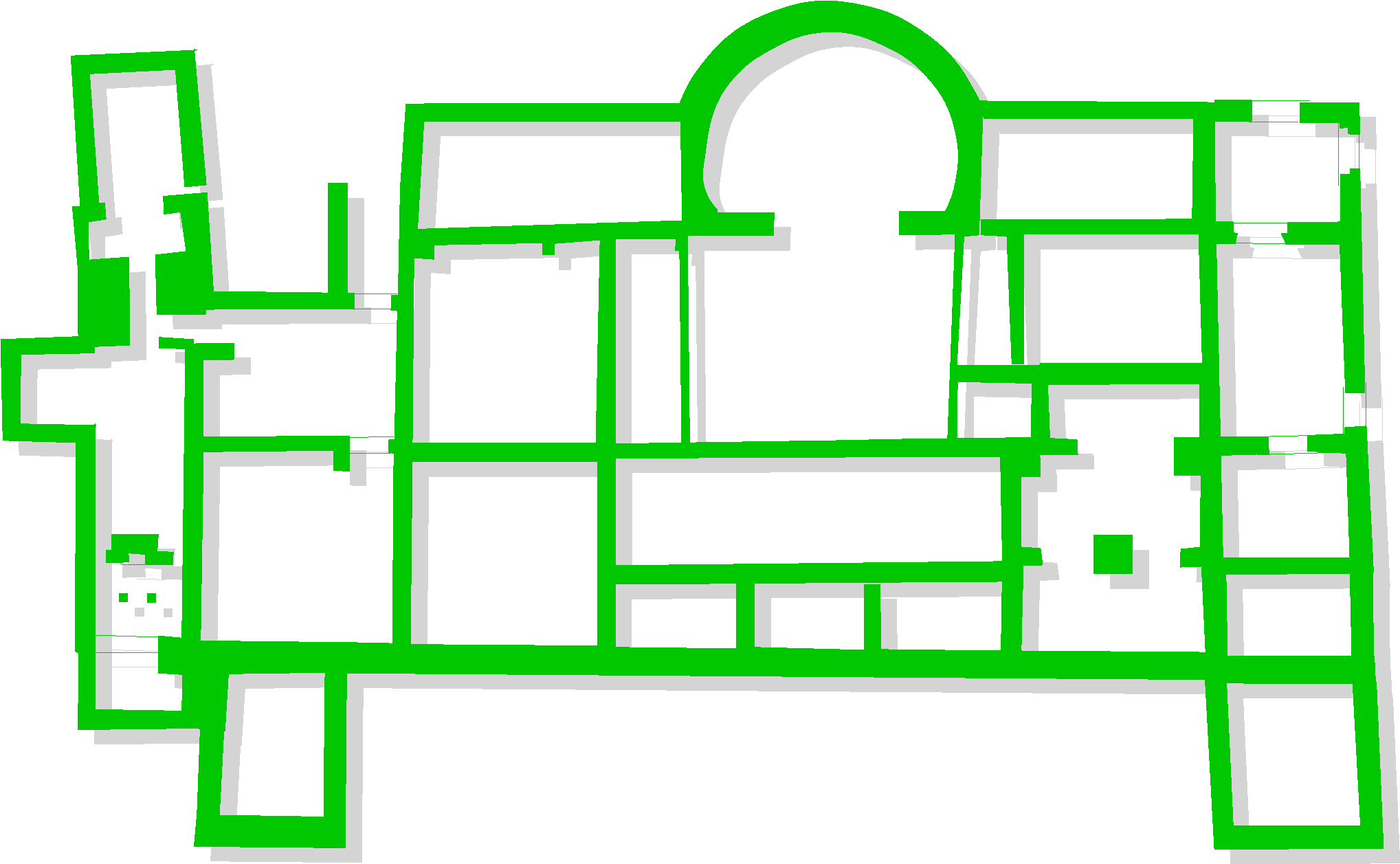
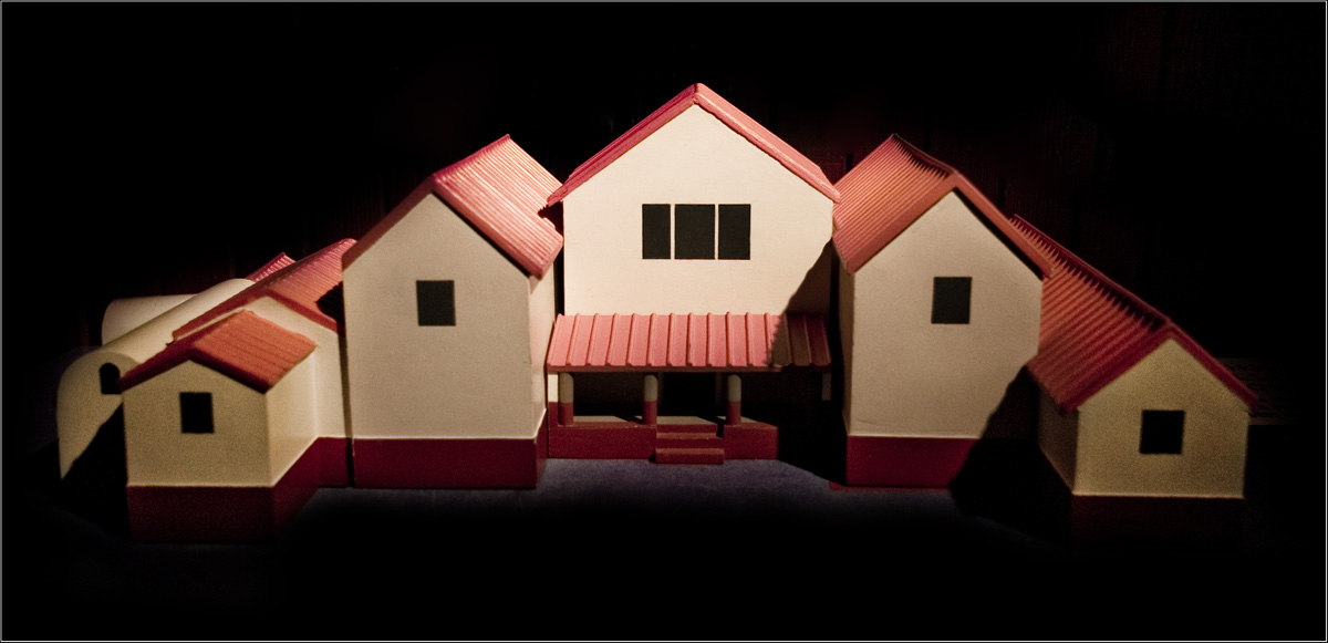
The first structure is put at about AD 75 in timber and daub, at about AD 82, at about AD 80 to 90, and as certainly standing by about AD 100. It was a winged-corridor house of at least four rooms, with a verandah toward the river and a deep room under the north wing that may have been a cult room from the start. Early in the second century a circular building about 5 or 5.4 metres across, possibly a shrine, stood to the north, and a separate kitchen of about 9 by 6.5 metres was built on its own terrace. A bath may already have existed, marked only by a wall of pink waterproof concrete under the later baths.
In the later second century, about AD 150 or as late as about AD 180, the house was enlarged and a heated bath suite was added on the south, with an outside door that may mean guests used it. The deep room was then certainly a cult room for a water deity or for nymphs, with a cistern in the floor and a painting of three water nymphs in a niche. Outside stairs imply that people beyond the family took part. The painted walls have been described as orange, red and green, and the room’s first height has been put at eight feet.
Two marble busts were later set in that room, one of them a man of about fifty, and their dates have been put at about AD 125 to 135 and about AD 155 to 165. One reading calls them two men of a single family and treats the search for names as of little value. Another identifies them as Pertinax, governor of Britain in 185 to 186 or resigned in 187, emperor for 87 days in 193, and his father Helvius Successus. A cornelian Victory gem of 23 by 19 by 5 millimetres has been read as a governor’s seal, and the house has been suggested as that governor’s country retreat.
The third century is told both as an abandonment of at least the first half, with a return marked by coins of Claudius Gothicus and Allectus and a rebuilding around 290, and as neglect between about 200 and 275 without a true break. In the years of neglect the kitchen became a tannery. Later the north range was replaced by five narrower rooms, three of them heated, the verandah became an audience chamber, and a granary and a temple-mausoleum were added.
The granary is 24.4 metres long, and its width is given both as 10.06 metres, or 33 feet, and as 10.7 metres. It is among the largest civilian granaries known in the province and had underfloor vents. The mausoleum, a square temple of 12.2 metres outside and a cella of 6.4 by 5.18 metres, received two lead coffins, called a young man and a young woman, or simply a man and a woman. The man’s coffin, with scallop shells, survived with gaming counters, glass, flagons and silver spoons, while the other had been robbed.
Around the middle of the fourth century an apsidal dining room was built across the west corridor. Its mosaic shows Jupiter as a bull with Europa, under a Latin couplet that turns a scene from Virgil toward that abduction, and the audience chamber shows Bellerophon on Pegasus killing the Chimera among the seasons. Coins of Constantine II in the concrete date one of the floors. Constantine had ended the official persecution of Christians in 313, and about forty years later, or about 360, the room above the cult room became a house-church.
The fallen plaster shows chi-rho monograms and six near life-size figures with raised hands, the clearest Christian paintings known from Roman Britain, with the closest parallel at Dura-Europos. Pagan worship may have continued in the room below. A hidden reading of the inscription has been proposed as the name Avitus or as a covert reference to Jesus, and the brief pagan revival under Julian has been offered as a reason for caution. The fire that ended the house is placed at about 367, early in the fifth century, at some undated point in that century, or at an abandonment around 420.
Anglo-Saxon England leaves potsherds and a hanging bowl, dated perhaps to the seventh century or to not later than about 500, and the site may have been a burial ground. The mausoleum was built into the chapel of St John the Baptist at Lullingstane, first recorded in 1115 and said in one account to have been standing at the Norman Conquest. The church was disused by 1412, when the two parishes were joined.
The later mansion has a gatehouse of 1497, passed to Percyval Hart in 1550, and was renamed Lullingstone Castle about 1740. The Roman pavement was struck by a fence post in about 1750, a sewer cut the building around 1895, and in August 1939 Ernest Greenfield and Edwyn Birchenough found debris in the roots of a fallen tree. Digging began on 7 January 1949 under Lieutenant-Colonel Geoffrey Meates and continued until 1961.
The Christian plaster was recognised in 1952, the nymph niche was revealed by a flood on 18 July 1956, and the mausoleum and the church above it were opened in 1958. A cover building begun in 1962 was opened on 2 April 1963. Meates’s volumes appeared in 1979 and 1987, and Michael Fulford wrote a guidebook in 2003. A renovation of 2006 to 2008 cost 1.8 million pounds after the cover began to leak.
In 2019 a granary trench and pits in the north meadow found stored grain and crop processing. Radiocarbon dates may place the granary a little after the later third century and allow use into the fifth century, while a later summary re-dates the building to the fifth century and reports Mesolithic material as the earliest occupation. In July 2020 a ditch and an eight-metre pit produced a jar set upside down over a lapdog. The digs of 2019 to 2021 involved more than 130 adults and 185 children.
Images






Detailed History
Lullingstone Roman Villa is a Romano-British house on an east-facing slope of the west bank of the River Darent, at Lullingstone near Eynsford in Kent. Its place on the Ordnance Survey National Grid is given as TQ53016508, and the same site is also centred on TQ 5301 6507 and marked at TQ 5299 6505. The grid is the British system whose origin lies west of the Isles of Scilly, so those letters and figures locate the house by distance from that origin rather than by latitude and longitude alone. The coordinates otherwise given for the ruins are about 51.36 degrees north and 0.20 degrees east.
The main house sat on a terrace cut into the hillside, about 50 metres west of the river, and measured about 32 metres north to south by 20 metres east to west. It faced the water. A courtyard is thought to survive between the house and the river.
The valley held a string of Roman houses. One account places Lullingstone with six others, naming those at Crofton, Crayford and Dartford. A scheduling description calls it one of at least five villas along a stretch of about nine kilometres of the Darent. Later work in the valley has named buildings at Dartford, Wilmington, Darenth, Farningham and Otford, and then Horton Kirby, Shoreham and Kemsing.
Dartford, Wilmington and Darenth were said to lie roughly two miles apart, and Darenth about two miles from Wilmington. Lieutenant-Colonel Geoffrey Meates, writing in 1964, thought the valley was farmed, that tile was probably made somewhere along it, and that a road once linked the houses. No such Roman road has been identified.
The people who lived here did so inside Roman Britain, the province of Britannia created after the Claudian invasion of AD 43 and held, on the usual reckoning, until about AD 410. Julius Caesar had already landed in 55 and 54 BC and then left. By AD 47 Roman control covered the lands south-east of the Fosse Way, which is the part of the island in which the Darent flows. Agricola’s campaigns of about 77 to 84 carried Roman arms far to the north, but this house belongs to the settled south-east.
Around AD 197 Britain was divided into Britannia Superior and Britannia Inferior. In the early fourth century the island was administered as four provinces under a vicarius, with a fifth, Valentia, attested later. The final withdrawal is placed around AD 410. The occupants of the villa are described as most likely wealthy Romans or native Britons who had adopted Roman customs.
Those Britons (historical) were the Celtic people of the island from at least the Iron Age, speakers of Common Brittonic, and in the south-east they lived through a Romano-British culture in which British Latin stood beside the older language.
The first house for which there is a structure was certainly standing by about AD 100, and perhaps as early as the AD 80s or around AD 80 to 90. Another account puts the earliest part at about AD 82. A third puts the first build at about AD 75, in timber and daub, with a rebuild in flint and tile in the second century. The visit account of the ruins says the house was begun in about AD 100.
Finds and soil that belong to no surviving wall suggest that people were on the slope before that first known structure. Hand-made pottery from the slope has been read as carrying elements of Belgic culture. The first known plan was a winged-corridor house of a kind common in Britain: a block of at least four rooms, a corridor or verandah on the river side linking wings, and a second corridor along the back. The northern wing stood over a cellar, later called the deep room.
It may have been only a store, but the number of ways into it, from the house and from outside, has been taken to mean that it was a cult room from the start. It was certainly one by the later second century. Little of this first phase can be seen, because later walls cover it.
Early in the second century a circular building 5.4 metres across, possibly a shrine, was put up north of the house. Another measure of that circle is about 5 metres, and its purpose has also been left unclear. It lies about ten metres north of the later mausoleum, and a dig in 1959 found a small circular temple there with a tessellated floor. There may already have been a bath house.
No certain trace of that early bath has been found, though an early wall of opus signinum, the pink waterproof concrete, on the south side of the first house and under the known second-century baths may belong to it. A separate kitchen behind the house, 9 metres east to west by 6.5 metres, is dated to the early second century and stands on its own terrace. An infant burial in the kitchen area has been recorded with a question mark as a possible foundation burial.
In the second half of the second century, possibly about AD 150 and perhaps as late as about AD 180, the simple house was greatly enlarged. A usual reading of such a rebuilding is that the owners had grown richer. A heated bath suite with a hypocaust was added on the south, cut off from the house by a corridor with an outside door at its west end, which may mean that people other than the family used the baths. The baths may sit where an earlier bath had been, and a well to the south supplied water.
More rooms were added on the north. The bath wing was later rebuilt around AD 290 after a gap that one account calls almost a century. During the dig the wing contained what Meates called a combustion chamber, filled with chalk and showing burnt charcoal that may have fed the heat.
By the time of the enlargement the cellar was certainly a cult room, probably for a water deity or for water nymphs. A small well or cistern sat in the middle of the floor. The walls were painted, including a picture of three water nymphs in a niche. That niche was later packed with stone and mortar, and the packing saved the painting.
The two doors from the house and from the east verandah were blocked. The only way in was then by steps at the north-west corner, reached by three further flights: from outside on the west, from outside on the east, and from the new northern range. The outside stairs suggest that people who were not of the family joined the cult. The walls of this room have also been described as orange, red and green panels, and the original height of the room has been put at eight feet.
The word basement, used for the same space, does not mean what a modern basement means. Geological layers of clay were used to argue that the few stairs down into it belong to this early period rather than to the fourth century, which had been the first guess. The bath room and the basement room have both been thought to belong to the years from the Flavian dynasty to the Nerva-Antonine dynasty, though the full extent of that house was not known when the digging began.
At some point in the third century the entrance steps were blocked. Two fine marble busts seem to have been set on or near the lowest steps, which still projected into the room. The only way in was then from above, presumably by a trapdoor. The busts have been read as a turn toward ancestors, or toward the imperial cult, and away from the water gods.
One account says that just after the third century the niche was covered and the room was painted again in white plaster with red bands, and that the busts were placed then. The busts were found in the cellar. One shows a man of about fifty. One has been called Hadrianic.
A scheduling description dates them to the second century, one to about AD 125 to 135 and the other to about AD 155 to 165, and says they are thought to represent two members of one family. It adds that the argument over who they are is of little value. The second, larger bust was more damaged when found. Its shoulders had been trimmed, perhaps to fit a niche, and the head had been broken from the body.
Weathering on it could mean that it once stood in the open, perhaps during a third-century change of occupation, and was moved into the cellar in the late third-century repairs. The pieces were probably carved in a Mediterranean workshop and brought in as personal possessions. What that description treats as clear is that they became the focus of veneration in the cellar in the late third and fourth centuries, probably when the original names had been forgotten.
A different reading identifies the busts with known men. One would be Publius Helvius Pertinax, son of a freedman, a senator, and governor of Britannia in AD 185 to 186, who was soon forced to leave Britain, later became emperor, reigned for 87 days in AD 193, and was murdered by soldiers of the Praetorian Guard. The other would be his father, named in that reading Publius Helvius Successus. Pertinax was born on 1 August 126 at Alba Pompeia in northern Italy.
His father’s name is also given simply as Helvius Successus, a freedman who had him educated. He served in Britain as tribune of the Legio VI Victrix before his governorships. His own life places a run of provinces, ending with Britain, between 175 and 185, and says that strict discipline in Britain provoked a mutiny in which soldiers once left him for dead, and that he was forced to resign in 187. Those years do not match a governorship confined to 185 and 186, and a portrait dated about AD 125 to 135 cannot be a likeness of a man born in 126 except as an infant.
Both the identification and the rejection of it are on record, and neither has been proved by an inscription from the house. If the busts do name the governor and his father, Lullingstone may have been a country retreat of the provincial governor rather than a working farm, which would help explain the scarcity of known farm buildings. Other buildings may still lie unfound. Martin Henig has also read a cornelian intaglio from the dig as the personal seal of the governor of that time.
That gem, found in the first excavations, is a Roman cornelian intaglio of Victory, 23 by 19 by 5 millimetres, one of the largest gems found in Britain. Stones of this kind were normally set in rings, and the size implies a large ring. Traces of gold survive on it. Henig took the ring to have belonged to a man of high status and wealth.
Victory is shown writing a message of triumph on a shield. The cutting has been thought to carry Greek traits, with elements of Nike and Aphrodite.
The middle of the third century is told in two ways. Pottery has been used to argue that the house was abandoned for at least the first half of the century, and one timeline has the baths rebuilt around AD 290 after almost a century empty. Coins of Claudius Gothicus and of Allectus are the evidence given for people returning in the second half of the century. Claudius Gothicus, also called Claudius II, was emperor from 268 to 270.
He defeated the Goths at the Battle of Naissus and died in a pestilence, possibly the Plague of Cyprian. Allectus, treasurer to the usurper Carausius, held Britain and part of northern Gaul from 293 until he was killed in 296, when Constantius invaded and a separate force cut off Allectus’s men. The other reading of the same years is narrower. Between about AD 200 and AD 275 the house decayed badly, and the excavator concluded that it may have been abandoned.
Coins and pottery, on that second reading, do not show a break in occupation, only neglect. It was in that time of neglect that the kitchen was turned into a tannery. A steeping tank, an oven, and a tannage pit lined with sandals were recorded there.
In the later third century the northern range was demolished and replaced by a narrower range of five rooms, three of them with underfloor heating. Apart from the baths, these were the only heated rooms in the house. The other rooms must have been warmed by movable braziers. The old verandah was widened into an audience chamber, and a new verandah was built to the east, with steps that probably led down to a garden by the river.
The baths were altered. A larger cold plunge was added beside the original one, and the old plunge may then have been a cistern for the house. The change may also reflect a change in the water supply. The end of the third century is also when the north side is said to have been remodelled.
A larger furnace for the hypocaust and an expanded bath block are placed in the third century as well.
Two buildings outside the house, the granary and the temple-mausoleum, are placed in this same later third-century phase, though the mausoleum is also put around AD 300 and in the early fourth century. The granary measures 24.4 metres, or 80 feet, by 10.06 metres, or 33 feet, in one account, and 24.4 metres east to west by 10.7 metres north to south in another. It is called one of the largest granaries known from a civilian site in Roman Britain. Unusually for a civilian granary, it had underfloor vents to keep the grain from spoiling.
It stood on the north side of the courtyard. In 1952 a building on the other side of the road was first called a basilica, and volunteers uncovered the stone bases of six columns. After another season in 1953 it was reidentified as the granary.
The temple-mausoleum was a square Romano-Celtic temple. Its outer wall was 12.2 metres, or 40 feet, on each side, around an ambulatory. The inner room, the cella, measured 6.4 metres, or 21 feet, by 5.18 metres, or 17 feet. It probably began as a shrine.
The cella was later used for two burials, in lead coffins, set in a deep square hole inside the inner square of two concentric squares. One account calls them a young man and a young woman, or a young man and probably a young woman. Another calls them a man and a woman, without the word young. The woman’s coffin was robbed in antiquity.
The man’s coffin survived in place, decorated with scallop shells and a cable pattern, and is displayed at the site. The grave goods that robbers left include pottery flagons and a bronze flagon, glass bottles and bowls, two silver spoons, and thirty glass gaming counters standing on what remained of a gaming board. A bone roundel with the head of Medusa, and a group of small bone pieces, may have belonged to a box that held the game. The mausoleum stands about six metres north of the house, on a terrace about six metres above it.
An article of 26 October 1958 called the building a pagan burial temple. That part of the site is not open to visitors. No Roman cemetery has been found for which this mausoleum was the focus. A second-century cremation that a badger turned up in 1982, about a mile away, has been tied to some other settlement.
Around the middle of the fourth century the centre of the house was rebuilt. An apsidal dining room, a triclinium, was built across the line of the western corridor and cut that corridor in two. The dining room and the audience chamber beside it, and the mosaics in both, are taken as signs that the owners were richer again. The dining room is the largest room on the west side of the main building, and it has been numbered Rooms 12 and 13, formerly Rooms 9 and 10.
It linked the rooms to the north and the south by way of a large verandah. The apse measures 6.25 by 4.88 metres at its greatest. A couch for three people, about 1.5 to 2 metres wide, could have faced the floor so that guests saw the pictures the right way up. The room has been read as a place for entertainment as well as for dining.
One mosaic shows Jupiter, or Zeus, as a bull, abducting Europa. Above it a Latin couplet reads, with one word restored, INVIDA SI TAURI VIDISSET IUNO NATATUS IUSTIUS AEOLIAS ISSET AD USQUE DOMOS. The sense is that if jealous Juno had seen the bull swimming, she would with greater justice have gone to the halls of Aeolus. The lines take an episode from the first book of Virgil’s Aeneid, in which Juno asks Aeolus, god of the winds, to drown Aeneas and his fleet, and turn that episode, ironically, onto Jupiter’s abduction of Europa, the story told in Ovid’s Metamorphoses.
Virgil, Publius Vergilius Maro, who lived from 70 to 19 BC, wrote the Aeneid, the Eclogues and the Georgics, and his verse was still a school text in the late Roman centuries when this floor was laid. The other great panel, in the audience chamber, shows Bellerophon, called a prince of Corinth, on the winged horse Pegasus, killing the Chimera, a fire-breathing she-monster. In the Greek telling Bellerophon is a Corinthian hero, son of Poseidon and Eurynome, foster son of Glaukos, who tamed Pegasus with a charmed bridle and later lost the favour of the gods when he tried to ride the horse to Olympus. Four roundels around him are the seasons: winter, spring, summer and autumn.
Four sea creatures, dolphins among them, surround the scene. Smaller motifs of hearts, crosses and swastikas fill the borders. The pictures have been read as myth, and also as devices meant to ward off the evil eye. These pavements are the only fourth-century mosaics known from Kent, and they are not easily matched in Britain.
A continental parallel has been suggested for parts of the plan of the house.
The date of the floor in Room 5 was taken from coins of Constantine II that were mixed into the concrete by accident. Constantine the Great, emperor from 306 to 337, had been proclaimed by his army at York in 306 and, with the Edict of Milan in 313, had ended the official persecution of Christians. The house-church paintings are placed about forty years after 313, which would put them near the middle of the century, and the conversion of the northern rooms into a chapel is also put at about AD 360. The mosaics may be of the same years as the church, or they may be a few years earlier, or about ten years earlier, before an owner declared himself a Christian in public.
The Christian room was made above the deep room. Thousands of fragments of painted plaster had fallen into the cult room when the upper storey collapsed, and they were pieced back together. Enough survives to show a large chi-rho on the south wall, the monogram formed by the first two Greek letters of the name of Christ. Six figures, near life size, stand on the west wall with their hands raised in the orantes position of early Christian prayer.
Another chi-rho is on the east wall. The north wall had further figures and pictures of buildings. Some of the paintings are now in the British Museum. They are described as the only known paintings from Roman Britain with a clear Christian symbol, and as almost unique.
The closest parallel named for them is a house-church at Dura-Europos in Syria, a city on the Euphrates founded around 300 BC and abandoned after the Sasanian capture of 256 or 257. The Lullingstone church had a narthex, or antechamber, perhaps for people not yet baptised and therefore not yet admitted to the Mass. Plaster from that antechamber was linked to the church. Three or four further rooms have been suggested as Christian space, including an antechamber and a vestibule.
The use, beyond worship, is not certain. Liturgical worship, including baptisms, has been proposed. The size of the paintings has been taken to mean that the owners were both Christian and rich. A suggestion of Gnostic elements in the decoration has been used to say that the question is not only how paganism and Christianity sat together, but what kind of Christianity this was.
The same years raise the question of the cult room still open underneath. It is not clear whether the family was keeping both the new faith and the old gods, whether some members held to the old cult while others had changed, or whether this was the ordinary Roman habit of honouring many gods at once. That last habit was unacceptable to Christians who refused other gods, which had been one reason for their persecution, as it was for Jews. If the Europa mosaic hides a name, one proposed reading takes every seventh letter from the end of the first word and arrives at Avitus.
Another starts at the first letter of the second line and takes every eighth letter, with the last letter of the inscription, and finds a covert reference to Jesus. A hidden name of Jesus would be odd if the mosaic and the church were of one date, unless the point was to lay a Christian meaning over a pagan picture. If the floors are about ten years older than the church, the owner may not yet have been open. It has also been suggested that Christians here still feared a return of persecution.
Julian, remembered as Julian the Apostate, was a nephew of Constantine, Caesar in the west from 355 and emperor from 361 until his death on 26 June 363, and the last non-Christian emperor. One account calls him emperor from 355 to 363. His public return to paganism was brief. Had it lasted, a cautious and coded Christianity at Lullingstone might later have looked prudent.
The end of the house is a fire, and the year is not agreed. One notice of 1952, published when the Christian plaster was first understood, put the fire at about 367. Another account puts it early in the fifth century. Another says only that it happened at some point in the fifth century, and that datable material is too scarce for a closer year.
A fourth says the fire gutted much of the house and that the place was abandoned in about AD 420, after occupation from about AD 75 until about AD 420. As the roofs fell, or as tiles and perhaps some walling were taken for use elsewhere, the building collapsed. It stood at the foot of a slope, and the hill washed soil over it. The deep room was partly destroyed.
Mosaic and plaster from the room above fell into it and lay untouched until the digging of 1949. When the house had been empty earlier, the basement walls and stairs had been stripped and were not restored until people came back. In the fourth century the deep room was redecorated, and the way in may have changed from stairs to a ladder, with shelves added in the niche so that part of the nymph painting was covered. Plinths against the north wall are recorded at a fourth-century level.
A pot from the deep room is marked with the word SVAVIS.
After about AD 400 the evidence is thin. Anglo-Saxon England, the early medieval period from the end of Roman rule in the fifth century until the Norman Conquest of 1066, is represented here by some potsherds and by a hanging bowl. The bowl has been dated perhaps to the seventh century, and also, by an earlier study, to not later than about AD 500. Either reading can be taken as a sign of early post-Roman Christianity, or of a high-status Anglo-Saxon burial, and the sherds have been used to suggest that the site was a burial ground in early Anglo-Saxon Britain.
The first dig found nothing it would call occupation between the fire and the Middle Ages. Kent was one of the kingdoms of that early English period. By the late sixth century small pagan dynasties held most of what became England, and in the seventh century those kingdoms were converted by missionaries from Ireland and from the continent. The hanging bowl, if it is of the seventh century, falls in that age of conversion.
If it is no later than about 500, it belongs to the much less documented years just after Roman government ended.
The temple-mausoleum survived at least as a ruin and was built into the chapel of St John the Baptist, probably in the eleventh century, when the hamlet of Lullingstane occupied the ground. The chapel is first recorded in 1115, and it probably began earlier. One account says it was standing at the time of the Norman Conquest and was one of the earliest chapels in the country. The Norman Conquest was the invasion of 1066 led by William, Duke of Normandy.
Edward the Confessor died in January 1066, Harold Godwinson succeeded him, Harald Hardrada of Norway was killed at Stamford Bridge on 25 September, William landed at Pevensey on 28 September, and Harold was killed at Hastings on 14 October. William was not secure until after 1072. A chapel already in use at Lullingstane would have been a small Christian building in a landscape that the Conquest was about to reassign. The church walls, of which three remained, lay over the Roman mausoleum.
A few burials were found on the south side of the church. The church was disused by 1412, when the parishes of Lullingstone and Lullingstane were joined. A drawing of 1769, published in 1788, describes the chapel as built of flints and Roman bricks, the west end mostly of the brick. It has also been called the lost church of St John the Baptist, Lullingstone.
Lullingstone House, as the later mansion was called, was built in the late fifteenth century. Its brick gatehouse survives from 1497. In 1550 the Lullingstane estate was sold to Percyval Hart, also called Sir Percival Hart, who already owned Lullingstone, and the two estates were no longer distinguished. The deer park was made in the reign of Elizabeth I.
The house was renamed Lullingstone Castle in about 1740. Some of the Tudor fabric still stands, at the outer gatehouse and on the east and north faces, though the house was much altered in the eighteenth century and the inner gatehouse is said to have been pulled down. Bombing in the Second World War destroyed the castle archives. Cottages that stood where the villa car park is now were demolished around 1914.
A geophysical survey and dig in the castle gardens in 2022 looked at the medieval house and at an inner moat filled in the late eighteenth century. That work belongs to the castle, not to the Roman floors.
The Roman house was not wholly forgotten. In about 1750, while a deer park was being fenced, a hole for a post cut a mosaic. John Thorpe wrote in 1788 that Sir Thomas Dyke of Lullingstone Castle had told him that Roman bricks had been dug up near the ruins of Lullingstane church, that the third post of the paling from the park gate — roughly where the present entrance to the villa is — had struck a tessellated pavement, and that Roman coins and instruments had at times been ploughed up near the church. The 1949 photograph of the pavement showed that damage as two holes.
Around 1895 the builders of a valley sewer cut through the centre of the building and did not report it. The damage from that sewer was recognised once digging began. Through the nineteenth century other Roman finds in north-west Kent, at Springhead, Wilmington in 1886, Dartford in 1895, and Darenth in 1895 under George Payne, did not lead anyone back to this slope. Villas at Farningham in 1925 and Otford in 1927 kept the search alive.
Ernest Greenfield, also written E. Greensfield and E. Greenfield, and Edwyn Birchenough, also written E. Birchenough, had begun a survey of the valley before the war.
In August 1939 they found Roman building debris in the roots of an upturned tree near the north gate of Lullingstone Park, and mosaic fragments with it. They asked whether this was the place struck in about 1750.
In 1947 Meates joined them. In 1948 he led a dig at another villa in Farningham. On 7 January 1949 the group opened the ground where the 1939 debris had lain. Permission was difficult because three owners shared the land: Kent County Council, the Lullingstone Castle estate, and the Kemp Town Brewery in Brighton.
By March 1949 the mosaic was exposed. By 30 July 1949 the pavement and the marble heads in the deep room had been shown in a published picture essay. That season also produced a large earthenware jug, hundreds of oyster shells, a bronze disc, a bronze ingot and a small perfume jar. Many of the finds were shown and stored at the castle, and they were listed in an addendum to a booklet on the Lullingstone silk farm by Lady Zoe Hart Dyke.
On 19 July 1950 Meates lectured at Maidstone Museum. By the end of 1950 a first leaflet showed three areas: the deep room with the busts, the mosaic of two panels divided by a step, and a bath block with a furnace, hot rooms and cooler rooms. The first interim report appeared in 1950. By 1951 Kent County Council owned the whole site.
Meates’s reports set a timeline from the first century through the post-Roman years, using coins, pottery, and the layers of soil and clay.
In 1952 work continued in the deep room and the baths. Painted plaster had been coming out of the deep room since 1949. On 22 February 1952 the plaster was announced as an early Christian chapel. The notice said that many thousands of fragments had fallen from an upper room into a basement when the villa was destroyed by fire in about 367.
C. Nicholson, who restored the plaster, and Professor J. Toynbee recognised the Christian meaning. At that moment only half of the basement could be dug, because a road covered the rest.
On 20 May 1952 the building beyond the road was announced. Through 1954 and 1955 several parts of the house were open. The granary was left uncovered. By December 1956 it had decayed so far that the Ministry of Works proposed to fill it with spoil from its dig at Eynsford Castle.
Medieval material from that backfill was found when the granary was opened again in 2019.
The summer of 1956 saw Meates’s first book, Lullingstone Roman Villa. In the same year the villa was treated as a national site. The Ministry of Works took responsibility for the place and for the digging, with Meates as director, and money followed. The road and the Darent Valley sewer were moved, and the eastern half of the deep room was dug for more of the Christian plaster.
On 18 July 1956 heavy rain sent mud down the hillside over the site. Clearing it took several years. The water also shifted flints in a wall of the deep room and revealed the niche with the water nymphs. The dig was then pushed west into the hillside, through a deep wash of clay and flints, and found the kitchen and the brewhouse.
On 5 August 1956 further walls were described in print. By September 1957 a long trench ran into the hill across several solid flint walls.
In 1958 the work was on the slope. Two buildings lay one above the other. The upper walls were three surviving walls of the parish church of Lullingstane. Under them were the concentric squares of the Roman mausoleum.
On 26 October 1958 a full-page account called the building a pagan burial temple. In 1959, north of the mausoleum, the circular temple was uncovered. In 1960 a temporary viewing platform was built and the remaining soil was taken off in preparation for a cover. The last season was limited to a few unanswered points, including a section along the old sewer cut.
The cover building was begun in 1962, finished in 1963, and opened on Tuesday 2 April 1963 by Richard Sharples, Parliamentary Secretary to the Ministry of Public Buildings and Works. None of the diggers were at that opening. A later account says the ruins were preserved under a specially designed cover in the 1960s, when the villa was taken into the care of English Heritage and opened to the public. The Ministry of Works was the body named in 1956 and 1963.
Mr Rook, called Rookie, who had been on the dig from 1949 and was remembered for models and drawing, died in 1973. Mrs Rook died in 1977. Their son Tony Rook wrote on Roman bath houses. In 1979 the first volume of Meates’s final account of the villa appeared.
The second, on the wall paintings and the finds, followed in 1987, after his death. On 31 May 1981, his eighty-first birthday, he unveiled a portrait of himself at the villa. The county archaeological society and a photographic society had arranged it. A recording was made of his talk.
He died four years later. Michael Fulford, born in October 1948 in Hampshire and Professor of Archaeology at the University of Reading since 1993, wrote a guidebook to the villa in 2003. He is known for the long excavation of Silchester and for work on towns, landscape and the economy of Roman Britain, and he was a Commissioner of English Heritage, now Historic England, from 2014.
A scheduling record of 1994 describes the monument as the Roman villa and the later Saxon church. The visible foundations, floors and walls of the house were left uncovered after the dig so that they could be shown to the public, and other features remain buried. What is protected includes heated rooms, a cellar, verandas, kitchens, baths, a dining room and an audience chamber with mosaic floors, bedrooms and store rooms. The ancillaries — the temple-mausoleum, the circular building, and the granary — were turfed over, with a plaque to mark them.
The cover building, toilets, signs, wooden seats, bins, fences, gates, and the tarmac of the road and the car park are excluded from the scheduling, while the ground beneath them is included.
Later work has been smaller. In 1983 D. S. Neal made a non-invasive survey that was used to reconsider the sequence of the buildings.
In 1986, before a pipe was laid, a small dig in the car park by the Central Excavation Unit showed that the car park had been river bed through Roman and medieval times. River gravels there held Roman tiles, and a layer of heavy flint cobbling may have been laid to firm the bottom for watering cattle. Wooden stakes in the spoil were read by one team as a possible revetment, and by another as timber from the filling of the car park before the 1949 digging, and not as ancient structure. A large fragment of Roman wall was noted in the backfill of a nineteenth-century sewer trench about 100 metres north of the villa.
In 2006 a watching brief in the car park found a layer of soil that probably survives from the Roman period. The cover had begun to leak late in the twentieth century. A renovation and display project of 2006 to 2008, costing 1.8 million pounds, was carried out so that objects from the site could be shown inside it. In 2007 magnetometry, earth resistance and ground-penetrating radar covered the ground immediately east of the cover, both sides of the access road to the castle, and the ground west of the car park.
High-resistance features west of the car park might belong to the villa, or to medieval Lullingstone.
The questions still listed as open are the character of a south outbuilding that Meates saw only while the cover was being built; the function and sequence of the northern range; whether more Roman buildings nearby would show a working farm or leave the governor’s-retreat idea standing; whether a jetty or other riverside structure existed; what buildings stood before the granary, if the place was either a retreat or a farm; how the mosaics and the final plan compare with houses elsewhere; where any cemetery lay; what the ground was used for before the villa; and secure dates for the major walls. The last two are hard to pursue without lifting floors that are still in place. The wider fields are the practical place to look.
In the summer of 2019 Anne Sassin directed a community dig for the Darent Valley Landscape Partnership. A trench of 2 by 3 metres was cut in a part of the granary that the 1952 and 1953 seasons had not reached, next to the northern box compartment, and test pits and trial trenches were dug in the meadow immediately north of the villa. Much of that meadow had been disturbed by services, including the valley sewer. Wendy Carruthers’s assessment of the plant remains found crop processing in the meadow, which fits the early and middle Roman dates already suggested for that ground by the 1986 work.
The granary samples produced a large quantity of well-preserved, partly cleaned grain, the sort of crop that had been stored, which supports calling the building a granary. Radiocarbon dates, in that assessment, may put the construction a little later than the later third century proposed by Meates, and they may show use continuing into the fifth century. A 2025 account of the same project says the granary was re-dated to the fifth century, and that the villa went on being used after the ordinary end of Roman rule in Britain. It also says Mesolithic material was found, the earliest occupation known on the site.
Both the cautious wording of the assessment and the later, firmer wording are in print. The project’s digs from 2019 to 2021 involved more than 130 adults and 185 children.
A second, smaller season in July 2020 opened two trial trenches on features seen by magnetometry in the field immediately north-west of the villa, on the ground that overlooks it. They found a chalk-cut ditch, possibly part of an early enclosure of the villa, and a pit about 8 metres across that could not be dug to the bottom because of its depth. Both looked early Roman. In the pit a storage jar had been set upside down over the body of a lapdog, which was read as a probable ritual deposit.
A later summary calls the ditch an Early Roman or Late Iron Age enclosure that had not been known before, and calls the pit a Roman ritual pit. Further work in that field was planned for 2021. The partnership had begun with a lidar survey of the valley and was planned, from 2019, to run until 2023. An interactive map of the Roman valley was made with the site’s custodians.
The 2019 reunion of the original dig, seventy years after 1949, was held at the villa on 19 July, with a temporary exhibition by the custodian Emma Freeman. Brian Philp, who had started on the site in 1952 as a schoolboy, and Jacob Scott, involved since 1957, spoke. Caroline Mackenzie launched a book on culture and society at the villa in the fourth century. An earlier reunion, for new interpretation boards, had been held on 17 September 2004, and the sixtieth anniversary of the digging was marked on the evening of 30 October 2009.
The ruins now stand inside the modern cover. Rising moisture has changed the conditions inside that building and has caused mould. Work is under way to improve the environment and to conserve the remains. The excavated ruins are closed to entry while that work continues.
Visitors can still meet volunteers and can look down on the remains through a viewing window. People with an allergy to penicillin or to Aspergillus, or with a respiratory illness that mould can make worse, are advised to wait until the work is finished. The site is also listed as closed until March 2027. A price list for 28 March 2026 to 16 March 2027 gives three bands of admission before any group discount: 9.26, 10.79 and 12.32 pounds for an adult, 8.50, 10.03 and 11.56 pounds for a concession, and 4.59, 5.35 and 6.12 pounds for a child.
Concession rates in that list apply to people of 65 and over, to jobseekers with the relevant identification, and to students with a student card. Members are admitted free. A group of 15 or more paying visitors is offered a reduction of 10 percent, and one tour leader and one coach driver are admitted free. The same list sets opening hours of 10:00 to 17:00 daily from 28 March to 24 October, and 10:00 to 16:00 daily from 25 October to 1 November, and it marks the site closed from 2 November to 16 March.
Groups are asked to book in advance.
Sources
- History of Lullingstone Roman Villa — English Heritage
- Lullingstone Roman Villa — English Heritage
- Significance of Lullingstone Roman Villa — English Heritage
- Research on Lullingstone Roman Villa — English Heritage
- School visits at Lullingstone Roman Villa — English Heritage
- Group admission prices and site opening times 2026/27 — English Heritage
- Lullingstone Roman Villa at 70 — Kent Archaeological Society
- Darent Valley community archaeology update — Kent Archaeological Society
- Discovering the rich archaeological heritage of the Darent Valley — Kent Downs
- Lullingstone Roman Villa monument record — Kent Historic Environment Record
- Lullingstone Roman Villa — Wikipedia
- Pertinax — Wikipedia
- Roman Britain — Wikipedia
- Britons (historical) — Wikipedia
- Claudius Gothicus — Wikipedia
- Anglo-Saxon England — Wikipedia
- Norman Conquest — Wikipedia
- Michael Fulford — Wikipedia
- Ordnance Survey National Grid — Wikipedia
- Allectus — Wikipedia
- Constantine the Great — Wikipedia
- Julian (emperor) — Wikipedia
- Dura-Europos — Wikipedia
- Bellerophon — Wikipedia
- Watling Street — Wikipedia
- LullingstonVilla-Kent Interior May2001.jpg — Wikimedia Commons
- Lullingstone AD 125.png — Wikimedia Commons
- Lullingstone AD 400.png — Wikimedia Commons
- Lullingstone nymphs.jpg — Wikimedia Commons
- 2008-08-25-01 GreatBritain Lullingstone.jpg — Wikimedia Commons
- Building containing Lullingstone Roman Villa - geograph.org.uk - 1735287.jpg — Wikimedia Commons
- Entrance to Lullingstone Roman Villa Exhibition, Lullingstone Country Park - geograph.org.uk - 1735291.jpg — Wikimedia Commons
- Lullingstone Roman Villa - geograph.org.uk - 1735295.jpg — Wikimedia Commons
- Lullingstone Roman Villa, Britannia (UK) (8412783821).jpg — Wikimedia Commons
- Lullingstone Roman Villa, Britannia (UK) (8412786559).jpg — Wikimedia Commons