

Madron, United Kingdom · Neolithic · United Kingdom
- Lanyon Quoit is a Neolithic chambered tomb in Madron, Cornwall, also called Lanyon Cromleh, the Giant's Quoit, and the Giant's Table.
- A granite capstone now sits on three uprights about 1.5 metres high, after the stones fell on 19 October 1815 and were raised again in 1824.
- Before the fall a rider on horseback could pass underneath, and the accounts disagree on whether three or four uprights first carried the stone.
- William Borlase dug a grave-shaped pit of black earth beneath the capstone, and later work in the mound met charcoal and bone in the cists.
- The mound is given as about 26 metres, about 27 metres, and 27.4 metres long, by about 12 metres wide, and the capstone as 5.3, 5.5, and 5.8 metres long.
- Edward Bolitho gave the ground to the National Trust in 1952, and the monument was scheduled on 10 August 1923, with the entry amended on 22 January 2015.
History
Lanyon Quoit is a Neolithic chambered tomb in the parish of Madron in west Cornwall, beside the road between Madron and Morvah. It is also called Lanyon Cromleh, the Giant's Quoit, and the Giant's Table, and it is classed as a portal dolmen and a chambered long barrow. The dates given for it run from about 3500 BC, and from 3500 to 2500 BC, while tombs of this kind are placed more widely between 4000 and 2351 BC and between 3400 and 2400 BC. No radiocarbon date for this chamber is stated.
A granite capstone now rests on three uprights about 1.5 metres, or 4 feet 10 inches, above a low mound. On 19 October 1815 the stones fell in a storm, the day the East Indiaman Delhi was wrecked near Marazion, and in 1824 Captain Giddy of the Royal Navy had them set up again. One support had broken, a piece of the capstone came away, and the figures 1824 were cut into an upright. Before the fall a rider on horseback could pass beneath the stone, and one elevation puts that older clearance at 2.5 metres, or 8 feet.
William Borlase recorded the monument in 1740, in memoranda of about 1750, and in a published plan of 1769. His text counts three uprights on a triangular plan, while a reading of the plan, and Cotton's later account, count four, of which three carried the capstone. He dug under the stone and found a grave-shaped pit of black earth, thought a burial likely, and also wrote that the disturbed soil proved nothing absolutely. Cotton understood him to have found no human bones.
The mound is given as about 70 feet by 20 feet in 1769, and later as 26 metres, 27 metres or 90 feet, and 27.4 metres long, by 12 metres or 40 feet wide. The capstone is given as 19 feet, 18 feet 2 inches, 5.3 metres, 5.5 metres, and 5.8 metres long, and as more than 12 tonnes and as 15 tons. Stones at the south end are read as one or more cists, as two cists, or as three, and charcoal and bone are recorded from cists in the mound. Those finds are separate from the urn and bones at West Lanyon Quoit, about 700 metres to the west.
William Copeland Borlase and Lukis studied the changed tomb in the later nineteenth century, and Hencken in 1932 read the earthwork as a long barrow. John Barnatt's survey, published in 1982, treats it as a much altered portal dolmen and leaves open whether the cists are earlier, later, or part of another mound. Edward Bolitho of Tregwainton gave the plot to the National Trust in 1952.
The monument was scheduled on 10 August 1923, and the entry was amended on 22 January 2015. A survey in 1990 was made to guide care of the site, and a scan in 2020 recorded the rebuilt stones and made the 1824 inscription easier to see. The mound is low and damaged, and buried remains are still thought to survive around the uprights and the cists.
Images


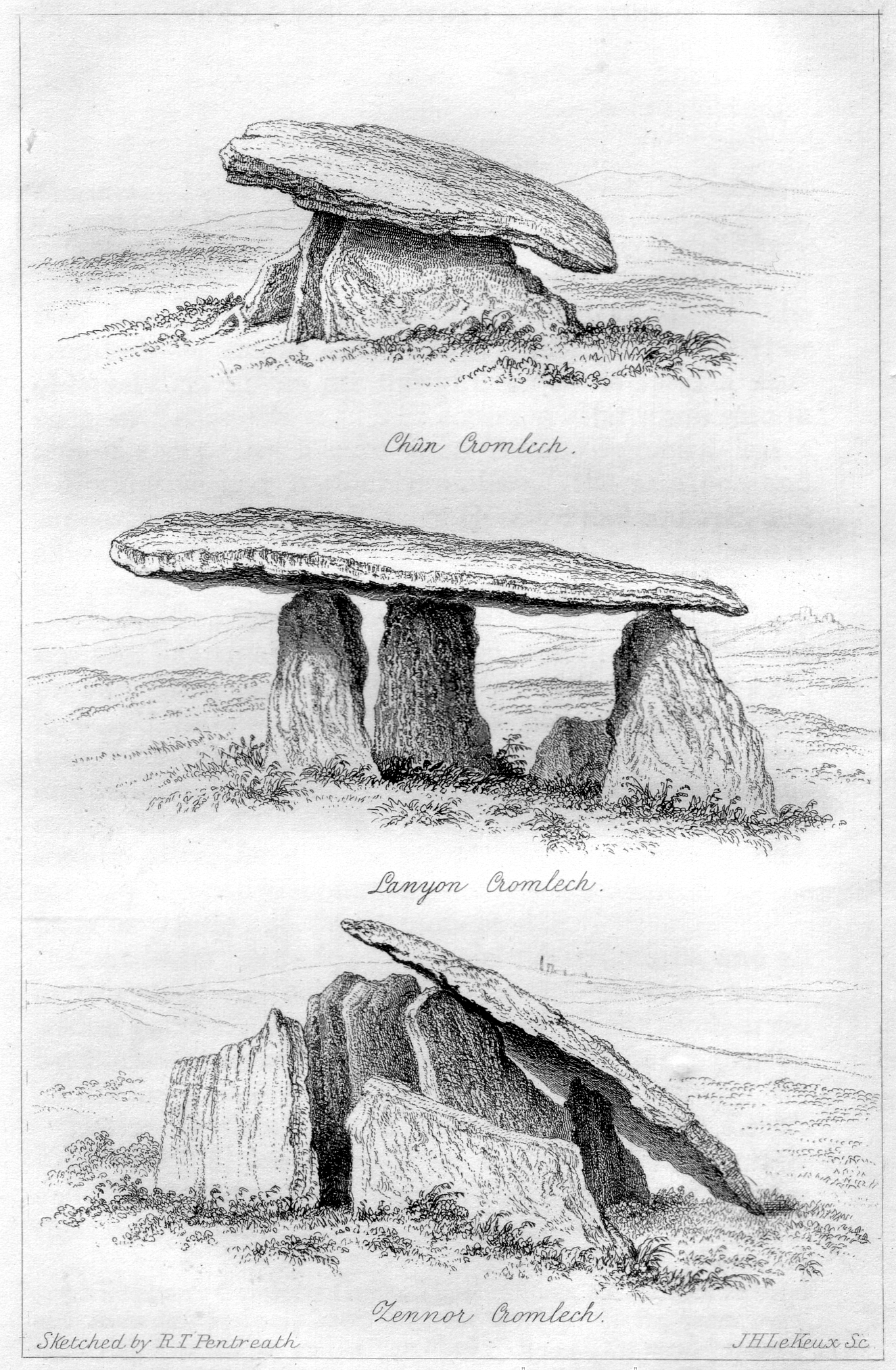


Detailed History
Lanyon Quoit is a Neolithic chambered tomb in the civil parish of Madron, in the west of Cornwall, on the Penwith peninsula. It stands close to the road that runs between Madron and Morvah, and the published positions cluster around 50.1473 degrees north and 5.599 degrees west, with one reading at 50.14750 north and 5.599167 west. The grid is given as SW 4297 3367, as SW 42974 33677, and as SW 42973 33681. One account places it two miles southeast of Morvah and fifty metres east of the road, northwest of Penzance.
William Cotton, writing in 1827, placed it about a mile and a half north of the church in the parish he spelled Maddern, close to the roadside, and said it took its name from the Lanyon estate. James Orchard Halliwell, writing in 1861, placed it some five miles from Penzance, on the right-hand side of the road from Madron to Morvah if the traveller was going that way, in a conspicuous place on open moor. The parish of Madron, in Cornish Eglosmadern for the village and Pluw Vadern for the parish, lies north of Penzance and is bounded by Sancreed, St Just, Zennor, Morvah, Paul, Gulval, and Penzance. Morvah, in Cornish Morvedh, is the small parish to the north.
The quoit itself is grouped with a holding called the Zennor Sites even though the parish is Madron.
The monument is a dolmen, a portal dolmen, and a chambered long barrow, and the names used for it are Lanyon Quoit, Lanyon Cromleh, the Giant's Quoit, and the Giant's Table. The last two are the names Halliwell said country people sometimes used. The granite capstone now rests on three uprights. Its present height is given as 1.5 metres, or 4 feet 11 inches, and also as 4 feet 10 inches from the ground, which was Cotton's measurement of each rebuilt upright and of the clearance under the stone.
The length of the capstone is given as 5.5 metres, or 18 feet, as 5.8 metres, as 5.3 metres or 17 and a half feet, as 19 feet in 1769, and as 18 feet 2 inches in 1827. The width is given as 2.7 metres, or 9 feet. The girth is given as more than 47 feet before the rebuilding, as 14.3 metres or 47 feet, as 44 feet 10 inches after a piece had broken away, and as 46 feet when Halliwell measured it. The thickness is given as 16 inches in the middle of the eastern edge and 2 feet at the western edge, and also as varying from 10 to 18 inches.
The weight is given as more than 12 tonnes and as 15 tons. These figures are not one measurement restated. They come from different years, and a piece of the capstone is said to have broken off when the stone was put back.
The age is not fixed by a radiocarbon date for this chamber. One account says it was built about 3500 BC. Another places the original tomb in the early Neolithic, from 3500 to 2500 BC. The monument types used for it, chambered tomb, portal dolmen, and long barrow, are banded to the Neolithic from 4000 BC to 2351 BC.
Chambered long barrows of this kind, as a class, are placed in the Early and Middle Neolithic, from 3400 to 2400 BC. The simple form of three or four uprights and a capstone has not been precisely dated, and it has been treated as the earliest type because of that simplicity. A general reading of such tombs allows a main phase as short as ten to thirty years, with longer use often found before and after construction. That reading is about the class of monument.
It is not a span measured in the soil at Lanyon.
Cornwall, in Cornish Kernow, is the westernmost county of the south-west peninsula. People were here in the Palaeolithic and the Mesolithic, after the last ice, and the land continued to be lived in through the Neolithic and the Bronze Age. Penwith is the granite end of that peninsula, one of the exposed parts of the Cornubian batholith, with Bodmin Moor, Hensbarrow, and Carnmenellis on the same spine of rock and the Isles of Scilly beyond. The stone of the quoit is the local granite.
Building a chamber of this size meant a community that could move blocks weighing many tons, set them as a grave or a ceremonial room, and raise a mound over or beside them. Chambered tombs in Cornwall, like the known examples of the class, were robbed in antiquity, so the precise purpose is not known from an intact burial. Investigation of long barrows, a broadly contemporary kind of monument in central and south-eastern England, has been used to argue that chambered tombs were places of ceremony as well as of interment, built by communities and used for more than one burial. Some long barrows have been linked with causewayed enclosures.
For Devon and Cornwall it has also been suggested that some chambered tombs may belong with hill-top or tor enclosures of Early Neolithic date. In West Penwith the hills named in that suggestion are Trencrom and Carn Galva. Those hills are not this tomb, and no source states that the people of Lanyon Quoit built either enclosure.
The later history of the same peninsula is not the history of the tomb, and it should not be folded into the building. In the Late Bronze Age the region sat in a maritime culture that reached across Ireland, Britain, France, Spain, and Portugal. In the Iron Age the people were Britons, speaking a language that would become Cornish, Welsh, and Breton. The first written notice of this coast is much later still.
Diodorus Siculus, using the earlier traveller Pytheas, described Belerion, or Land's End, as a place where the inhabitants prepared tin and merchants carried it to Gaul and then overland to the mouth of the Rhône. Timothy Champion has pointed out that this account does not say Phoenicians sailed to Cornwall. It puts the production in local hands and the carriage in the hands of merchants. Isotopic work has been used to suggest that some tin found off Haifa may have come from Cornwall, but that metal belongs to the Bronze Age trade in tin, not to a date carved on this chamber.
Under Rome the county was remote from the main centres, the nearest of which was Exeter. After the Roman administration, the west formed part of Dumnonia. None of that written history reaches back to the raising of the quoit. It does show why later people, living on a coast already famous for tin and for granite, kept returning to a tomb they could still see.
William Borlase is the first person named as having described Lanyon Quoit. He was born at Pendeen on 2 February 1696, a date also given as 1695/6 because the year then changed in March, and he died at Ludgvan on 31 August 1772. From 1722 he was rector of Ludgvan, and from 1732 he was also vicar of St Just. He was admitted a Fellow of the Royal Society in 1750.
His Observations on the Antiquities of Cornwall appeared at Oxford in 1754, and the second edition, Antiquities, Historical and Monumental, of the County of Cornwall, appeared in London in 1769. The Natural History of Cornwall followed in 1758. One account says he first described the quoit in 1740. His parochial memoranda are cited for about 1750.
The published ground plan and elevation, and the long description quoted from the revised book, belong to 1769. His elder brother Walter Borlase was vicar of Madron and mayor of Penzance, so the family already had a hold on this parish. William Borlase married Anne Smith in 1724. She died in 1769, the year of the revised antiquities.
Their great-great-grandson was William Copeland Borlase, who would dig in Cornwall a century later.
Between 1744 and 1746 William Borlase, acting as a magistrate, moved against Methodist preachers. Warrants he issued were used to seize preachers and put them aboard Royal Navy ships for service abroad. On 2 July 1745 he laid hands on John Wesley, in Wesley's own journal, meaning to send him to serve the king, and then withdrew when he understood that Wesley was a gentleman. That episode is not a event at the quoit.
It is the public life of the man who measured it, in a Cornwall where the established church and the new Methodist societies were in conflict, and where the Royal Navy took men by impressment. The navy of that century was the largest maritime force of its time. Its dockyards and its hunger for crews were part of the county's coast, from Mount's Bay to the later base at Devonport. Borlase also wrote on the Scilly Isles, sent fossils to the Ashmolean, corresponded with Alexander Pope, and recorded the agitation of the sea in Mount's Bay on 31 March 1761 after the Lisbon earthquake.
The quoit was one monument among the many he put on paper, but it is the one whose stones were afterwards moved.
In the 1769 text he called it a singular monument in the parish of Madern, in the tenement of Lanyon. He wrote that three stones stood erect on a triangular plan. The area they described was seven feet long, and it ran north and south, not east and west as at Molfra. There was no kistvaen, no area marked out by side stones, under the quoit.
The capstone was more than 47 feet in girt and 19 feet long. In the middle of the eastern edge it was 16 inches thick, less at each end, and at the western edge it was 2 feet thick. The two chief supporters did not stand at right angles to the front line, as in other cromlechs, but obliquely. He imagined that the weight of the capstone had forced them from an earlier position.
The stone stood so high that a man on horseback could be under it. Cotton later rendered that sentence as a man on horseback riding under the incumbent stone. A later summary of the 1769 elevation gives the capstone as 2.5 metres, or 8 feet, above the ground, and the girth as 14.3 metres, or 47 feet.
In that 1769 text he says he caused a pit 4 and a half feet deep to be sunk under the quoit and found it all black earth that had been moved. He would have gone deeper, but the gentleman who owned the ground told him that a few years earlier the whole cavity had been opened, on account of a dream, to a depth of six feet, and that the diggers then stopped. The cavity was the shape of a grave. It had been rifled more than once.
Nothing more than ordinary was found. A citation of his memoranda places an excavation beneath the capstone, a grave-shaped pit of black earth, about 1750. Cotton, reading the doctor afterwards, said no human bones were discovered, and that the appearance of the earth still led Borlase to conclude a body had been interred. Borlase's own paragraph is more cautious and more suggestive at once.
He wrote that the black earth, after so many disturbances, allowed nothing to be absolutely concluded, and also that a grave-shaped pit six feet deep made a human body not improbable, and that the length of the bank and the disordered stones at the south end made the place look like a burial for more than one person.
He described the bank as not two feet higher than the adjacent soil, about 20 feet wide and 70 feet long, running north and south. At the south end were many rough stones, some set on end, in no order, but put there by design, though their original position was hard to recover. About 80 yards to the north-west he noted a high stone. A later reading of his plan does not match the sentence about three stones.
That reading says four slender orthostats stood in parallel, each with its long axis from north-west to south-east, in a rough line running north and south along the capstone, and that three of them carried the stone. Cotton, after the rebuilding, also said the quoit had originally been supported on four uprights, describing an open area seven feet long from north to south, and that it had not been an enclosed kistvaen like the cromlechs at Molfra and Chun. The eighteenth-century accounts used by a modern summary say there were four supporting stones and that a person on horseback could ride under the capstone. The prose of 1769 says three stones on a triangular plan, already pushed out of an earlier line.
Both descriptions have to stand, because both are what the surviving accounts say.
On 19 October 1815 the quoit fell in a storm. That is the date given for the collapse, and it is the date under which the East Indiaman Delhi, of the British East India Company, was driven ashore and wrecked near Marazion. She was on a voyage from Batavia to London. The same day's list records the French ship Flora wrecked in Mount's Bay, her crew rescued.
Cotton wrote of a very violent storm in the year 1815, when the Delhi was wrecked in Mount's Bay, and said the quoit fell and one supporting stone was broken. He thought it probable that earth under the chamber, loosened by repeated digging, had been washed out by the heavy rain, and that this caused the fall. John Barnatt, whose survey was published in 1982, suggested a different mechanism that can sit beside the rain. He thought the capstone came down because the single orthostat on the south leaned and at last fell.
One supporting stone was too badly damaged to be set up again. A piece of the capstone itself broke, either in the fall or while the stone was being raised, and both moments are stated.
Fortescue Hitchins and Samuel Drew belong to the book that carries this story into print. Fortescue Hitchins was born at St Hilary on 22 February 1784 and died at Marazion on 1 April 1814. He was the youngest son of Malachy Hitchins, the astronomer and vicar, and he worked as a solicitor at St Ives. He published poems, and he compiled material for a history of Cornwall.
He died more than a year before the stones fell. Samuel Drew, born near St Austell on 6 March 1765 and died at Helston on 29 March 1833, was the Methodist writer called the Cornish metaphysician. He had been a shoemaker at St Austell, published on the soul and against Thomas Paine, and from 1805 lived by his pen. His life says that in 1814 he completed the history of Cornwall begun by Fortescue Hitchins.
The published volume, edited by Samuel Drew, appeared in 1824 under the title of a history of Cornwall from the earliest records and traditions to the present time, and that 1824 book is the one cited for the fall. The two dates remain side by side. The completion is placed in 1814, the year Hitchins died and the year before the storm, and the published history is 1824, the year the stones were raised again.
Nine years after the fall, local people raised a subscription and set the quoit up. The year is 1824. Captain Giddy of the Royal Navy superintended the work. Cotton says the inhabitants subscribed, and that the machinery used in replacing the Logging Rock was brought to bear, and that Giddy's exertions overcame every difficulty.
The Logging Rock is the Logan Rock at Treen, in the cliff castle of Treryn Dinas, a granite boulder that had rocked at a touch. In April 1824 Lieutenant Hugh Goldsmith of the Royal Navy, a nephew of the poet Oliver Goldsmith, and ten or twelve men of the cutter HMS Nimble levered it from its perch to disprove a claim, made in the 1754 antiquities, that no mechanical force could shift it. The rock slid into a crevice. The people of Treen, for whom it was a living, demanded that the Admiralty strip Goldsmith of his commission unless he restored it at his own expense.
Davies Gilbert persuaded the Admiralty to lend the apparatus. Thirteen capstans with blocks and chains came from the dockyard at Plymouth, and the Admiralty contributed 25 pounds. At 4.20 in the afternoon of Tuesday 2 November 1824, before thousands of spectators and with more than sixty men, the Logan Rock was put back. The recorded cost was 130 pounds, 8 shillings, and 6 pence.
It rocked again, but less easily. Cotton's phrase is that this machinery was used for Lanyon Quoit in the same year, under Captain Giddy. He does not give the day, so the order of the two jobs inside 1824 is not fixed beyond that wording.
The Royal Navy in 1824 was the force that had come through the French wars and the War of 1812. From the 1790s to 1815 it had kept enemy fleets in port, won at Trafalgar in 1805 under Lord Nelson, and relied heavily on impressed men. After 1815 it had no rival that could match it, and its dockyard at Plymouth, later counted as Devonport, was the store of capstans and chain that a lieutenant could borrow for a Cornish stone. Captain Giddy used that kind of gear on a tomb rather than on a ship.
The result was not the monument William Borlase had drawn.
Cotton measured the rebuilt cromlech. The covering stone was nearly flat and triangular in figure, 44 feet 10 inches in circumference, 18 feet 2 inches in its greatest length, 9 feet wide, and 15 tons in weight. It stood on three uprights, each 4 feet 10 inches high. Their tops had been made level and their positions a little altered.
A piece had been broken off the top stone in the raising, and he marked the break on his plan. The height from the ground was only 4 feet 10 inches, against the horseback clearance of Borlase's day. The figures 1824 were rudely inscribed on one of the supporting stones. A later note places the carved date AD 1824 on the southern upright.
A scan made in 2020 found that date hard to see with the eye and easier to see in the model.
Other accounts of the same rebuilding do not agree about how far the stones were turned. One says that a single upright was turned at right angles, that this was the only change of orientation, and that the capstone stayed aligned much as it had been before the fall. John Barnatt read that southern stone as the one that had leaned and fallen, and he thought it was put back at right angles to give the chamber more stability. Another account says the whole quoit was re-erected at right angles to its original position, and that the three remaining uprights were shortened and squared off, so that the tomb lost the rectangular box-like shape of the other quoits.
Another says the positions were only a little altered and the tops levelled. Another says every one of the four orthostats was moved, and that when the present plan is set against Borlase's plan only one of the old uprights can possibly stand where it did. W. C.
Lukis recorded that the covering stone was replaced upside down, and a later account has the capstone possibly upside down and that part of it broke off in the collapse. Lukis's plan of 1879, published with William Copeland Borlase in 1885, shows an arrangement of uprights quite different from the eighteenth-century drawing, with the capstone only about 1.5 metres above the ground. Halliwell in 1861 saw three upright unhewn blocks and, nearby, three fallen stones, of which at least one had certainly been a supporter. Under the capstone today there is also a recumbent granite stone broken in two, and a low upright.
A further stone on the south-east edge of the mound may belong to the chamber or to a cist. The rebuilt quoit is therefore described, in different sentences that cannot all be softened into one, as slightly shifted, as turned in one upright only, as turned bodily through a right angle, as set upside down, and as preserving only one stone that might still be in its old place.
The mound is as disputed as the chamber. Borlase's bank was about 70 feet long and 20 feet wide, and less than two feet high. Later measurements give a long barrow of 26 metres by 12 metres, of 27 metres or 90 feet by 12 metres or 40 feet, and of 27.4 metres by 12 metres, oriented north to south, with the chamber at the north end. The earthwork is up to 0.6 metres high, mostly earth, with fist-sized to head-sized granite showing in worn places.
It is covered by grass and bracken. The outline is damaged and difficult to see, and the edges are poorly defined. The greatest apparent height is around the southern stones, and that height may be spoil from pits rather than the original mound. Three shallow pits lie on the north-south axis, one of them north of the uprights and two toward the cists.
Ridge and furrow comes in on the long sides, where quarry ditches for the building of the mound might have been expected and are not now visible. A moorstone quarry pit cuts the north end. Irregular edges and pits are put down to antiquarian digging and to the taking of stone for field walls about 10 metres to the south.
At the south end are further large stones. They are read as the remains of one or more cists, as at least two cists formed by at least four orthostats, and as three granite cists toward the south-east edge of the mound. Borlase and Lukis are both cited for cists in the mound, and one of those is said to have held charcoal and bone. William Copeland Borlase, in the later nineteenth century, found a ring of stones set on edge in the centre of a long low barrow, and that ring was interpreted as part of the long barrow belonging to the chamber.
A separate note says he recorded a ring of stones containing bones and charcoal, destroyed about 1868, 6.4 metres to the south-west of the quoit. Lukis is said to have placed a cist 15.2 metres to the south-east. John Thomas Blight recorded a mound and a retaining circle which may be the same feature as Borlase's ring, but the details differ. Vivien Russell treated the three as separate barrows, and none of them can be identified on the ground.
Halliwell saw a stone-and-earth circular barrow about 18 feet in diameter between the cromlech and the road. These rings, cists, and small barrows are not the capstone chamber. Charcoal and bone from them are not the black earth William Borlase found under the quoit, and they are not the urn and bones from the other tomb to the west.
That other tomb is West Lanyon Quoit, also called Lower Lanyon Quoit. It lies about 700 metres west of Lanyon Quoit, and about 300 metres south-west of the road, near grid SW 423337. It was scheduled on 14 December 1926. Only two large stones show now.
One supporter, probably the south-west stone of its chamber, still stands 1.6 metres high and 1.5 metres wide, and the capstone leaning on it is 4.1 metres long and 2.6 metres wide. In the late eighteenth century the landowner had the barrow dug away for compost. After nearly a hundred cart-loads, the servants found the supporters of a cromlech, the cover stone slipped off on the fourth side but still leaning. The chamber ran from north-east to south-west, open at the north-east, and it measured about 10 feet by 5 feet by 5 feet.
Digging inside produced a broken urn, ashes, and human bones. Because the chamber was full of mound material, it is thought to have been opened already, and the urn and bones are read as a secondary cremation, probably of the Bronze Age. Those finds belong to West Lanyon Quoit. They must not be told as the contents of Lanyon Quoit.
William Copeland Borlase was born at Castle Horneck near Penzance on 5 April 1848 and died in Bloomsbury on 31 March 1899. He was buried on the east side of Highgate Cemetery. The archaeological work of his great-great-grandfather shaped his youth. In 1863 he worked at the settlement and fogou of Carn Euny, and he asked John Thomas Blight to engrave the report.
His Naenia Cornubiae, on the sepulchres and funeral customs of early Cornwall, appeared in 1872, and in it he reproduced the older etchings and preferred them to later sketches because the monument had been so greatly changed. In 1885 he and W. C. Lukis published the Cornwall volume of the prehistoric stone monuments, with measured plates.
He has been credited with opening about two hundred barrows in the county, and criticised because accounts were written for only about a tenth of them. He sat in Parliament for East Cornwall from 1880 until the seat was divided in 1885, then for St Austell, and in 1886 he was Parliamentary Secretary to the Local Government Board. Debt and scandal ended that career. He resigned on 29 April 1887.
The drawings and the 1872 and 1885 books are what tie him to this quoit, not the later ruin of his seat.
John Thomas Blight was born near Redruth on 27 October 1835 and died on 23 January 1911 in the asylum at Bodmin. By about twenty he had published on the antiquities of Penwith. A Week at the Land's End is dated 1861, and one account of the quoit dates that book to 1864. An illustration of the rebuilt tomb is cited from the 1876 edition, and an 1858 sketch of his is also reproduced.
An etching by R. T. Pentreath in 1857 already shows the stones in their present arrangement. Blight's father had settled the family in Penzance.
Patrons failed him, and in the mid-1860s he broke down and was kept at Bodmin for the rest of his life. His drawings matter because many of the monuments he recorded have since gone, and because his view of Lanyon is one of the early pictures of the quoit after 1824, not of the chamber Borlase saw. Halliwell, who had been one of those patrons, wrote in 1861 that the prints then current were still copied from Borlase and did not show the tomb as it stood. He also wrote down a tradition that the first battle fought in England was decided in the locality of Lanyon Quoit.
That is a tradition he recorded. It is not a battle named, dated, or shown in the ground.
H. O. Hencken, in The Archaeology of Cornwall and Scilly of 1932, is the writer credited with identifying these remains as a long barrow. He found only scant traces, but enough to say the mound was not round and that its long axis ran north and south.
Glyn Daniel in 1950 described a long barrow 27.4 metres by 12 metres, oriented north to south, with a chamber at the north end of three orthostats and a capstone 5.8 metres long whose arrangement was not the original one, and with more large stones at the south end that might be one or more cists. The Ordnance Survey in 1960, at 1 to 2500, found the barrow very mutilated under grass and bracken, its outline hard to determine because the ground is uneven. Russell's West Penwith Survey of 1971 listed the long barrow. A resurvey that year noted the cists recorded by Borlase and Lukis.
In 1980 Sheppard observed that the remains of the mound did not appear to be covered by the scheduling of the quoit.
The monument was scheduled on 10 August 1923. The entry was amended on 22 January 2015. The reasons given for protecting it are that the site, even after reconstruction, still holds archaeological potential, that a hybrid of chambered tomb and long barrow is rare, that it can add to what is known of Neolithic burial and social organisation in the county, and that it stands with other protected monuments in a surviving prehistoric landscape. In 1952 Edward Bolitho of Tregwainton, who then owned it, gave the plot with the monument to the National Trust.
The land is also counted as part of an Area of Outstanding Natural Beauty and of a Heritage Coast. A survey by N. Thomas for the Cornwall Archaeological Unit in 1990 was made to guide interpretation and management. The published notice of that survey does not list new objects from the ground.
John Barnatt's plan, drawn before 1982 and published that year, treats Lanyon as a much altered portal dolmen. He thought the original form was probably a rectangular box, with a possible antechamber on the north side. The fieldwork found an irregular mound cut in several places, mostly by antiquarian digging, a capstone on three orthostats, three fallen stones, one displaced stone on the south-east edge, and at least two cist-like settings in the south end. The record of the site then sets out four ways to read the chamber and the cists, and it does not choose among them.
The chamber and the long mound may be primary, with the cists as later burials cut into the mound. The chamber may have stood under a round or oval barrow, and the cists under a separate barrow to the south, the two mounds later merged by digging. The cists may have lain under an earlier round or oval barrow that a long barrow and chamber afterwards covered, a sequence compared with Dyffryn Ardudwy in Gwynedd and with Wayland's Smithy in Oxfordshire, which are other monuments and not parts of this one. Or the cists may belong to a late Neolithic or Bronze Age round barrow set on top of an earlier long barrow that had gone out of use.
The last two readings assume that one way of building barrows replaced another. What the ground is said to retain, despite the disturbance, is significant buried deposit related to the cists and the orthostats. Antiquarian mentions of charcoal and bone in the cists are the basis for that hope. No intact burial under the capstone is described.
In 2020 the Penwith Landscape Partnership asked for three-dimensional scans of four monuments, Lanyon Quoit among them, as part of work called Ancient Penwith. Tom Goskar's record of that work says the scans had to be accurate enough for later condition monitoring, and that they could also be turned into models for people who could not reach a rough or private site. The date of the 1824 re-erection, hard to see on the stone, shows more clearly in the scan. The point cloud, looked at from above, shows the alignment of the uprights as they stand now.
The scan is a record of the rebuilt tomb. It is not a new excavation, and it is not said to have produced a find of bone, pottery, or flint from the mound. A revision of the monument record dated 24 January 2025 sets out the chamber, the mound, the cists, and the older fieldwork. It does not report a dig of that year.
A note published on 25 May 2026 prints Borlase's 1769 description and Cotton's 1827 description again, with their plans. That too is a return to the old accounts, not a new opening of the ground.
What the place was for, on the evidence that exists, is a Neolithic tomb and a place of repeated attention. The chamber marked a spot on a low bank in open ground, large enough to be seen from the road that later ran beside it, and built of granite that a group of people had to haul and set. Borlase thought a body likely, and more than one burial likely, and he also wrote that the disturbed earth proved nothing absolutely. Later cists held charcoal and bone according to the antiquaries, and those cists may be later than the chamber, or earlier, or part of another mound.
The tomb was already ruined and robbed, on the general evidence of Cornish chambered tombs, long before a storm on 19 October 1815 threw the capstone down. The rebuilding of 1824 kept the stones in the landscape and changed their arrangement so thoroughly that the quoit is now called one of the least authentic of Cornwall's prehistoric monuments, and also one of the best known. The stake in the ground that remains is the unexcavated deposit around the uprights and the southern cists, and the chance of reading, from a mound only a few tens of metres long, whether this was one burial monument or several built one upon another. No source states a ticket, an hour of opening, a rule of dress, or an entry charge for the stones themselves.
Sources
- Lanyon Quoit — Wikipedia
- William Borlase — Wikipedia
- William Copeland Borlase — Wikipedia
- John Thomas Blight — Wikipedia
- Fortescue Hitchins — Wikipedia
- Samuel Drew — Wikipedia
- Cornwall — Wikipedia
- Royal Navy — Wikipedia
- Logan Rock — Wikipedia
- West Lanyon Quoit — Wikipedia
- Madron — Wikipedia
- Morvah — Wikipedia
- List of shipwrecks in 1815 — Wikipedia
- Chambered long barrow known as Lanyon Quoit — Historic England
- Lanyon Quoit Neolithic chambered tomb — National Trust
- Barrow which once covered Lanyon Quoit — National Trust
- Lanyon Quoit, Madron, Cornwall — The Northern Antiquarian
- Impossible views: 3D scanning monuments in West Penwith, Cornwall — Tom Goskar
- Lanyon Quoit — Cornish Ancient Sites Protection Network
- An Archaeological Evaluation of Lanyon Quoit, Madron, West Penwith — Archaeology Data Service
- Lanyonquoit3.jpg — Wikimedia Commons
- A Week at the Land's End 04.jpg — Wikimedia Commons
- Cornish-Cromlechs-1857.jpg — Wikimedia Commons
- Lanyon Quoit (Explored).jpg — Wikimedia Commons
- Lanyon Quoit - geograph.org.uk - 291130.jpg — Wikimedia Commons
- Lanyon Quoit - geograph.org.uk - 551053.jpg — Wikimedia Commons
- Dusk at Lanyon Quoit - geograph.org.uk - 654887.jpg — Wikimedia Commons
- Lanyon Quoit (again). - geograph.org.uk - 654886.jpg — Wikimedia Commons
- A wet day at Lanyon Quoit - geograph.org.uk - 971042.jpg — Wikimedia Commons
- Lanyon Quoit - geograph.org.uk - 1071381.jpg — Wikimedia Commons