
Orkney Islands, United Kingdom · Neolithic · 3701 BCE – 2801 BCE · United Kingdom
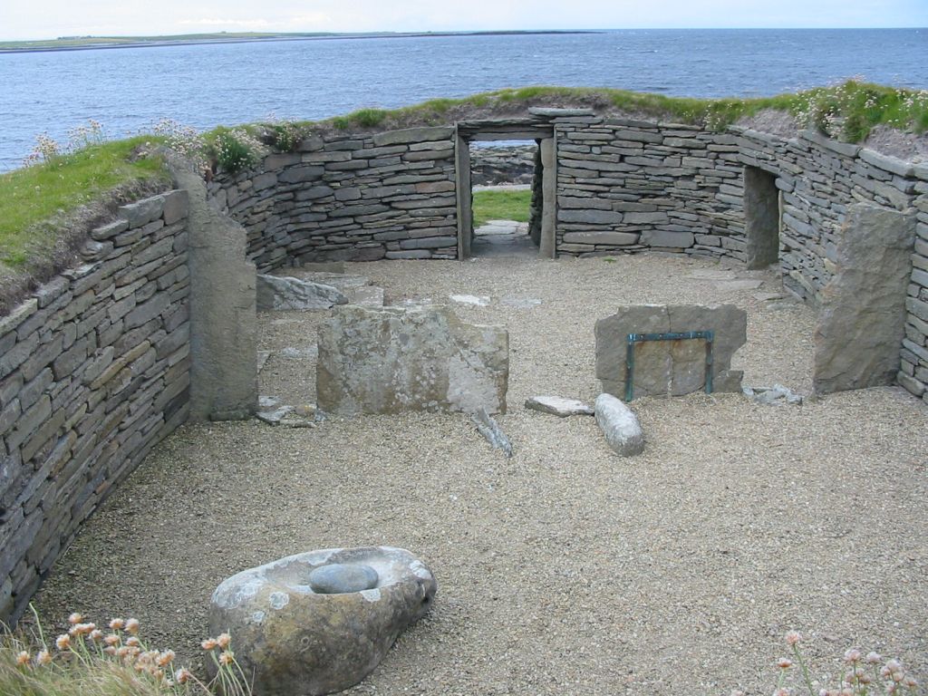
- Two stone houses still stand side by side on the west coast of Papa Westray, with doorways facing the sea and walls about 1.6 metres high.
- They were built on an older midden, and the smaller house was blocked while the larger one was still in use.
- Cattle, sheep and a few pigs were kept here, with barley, possibly wheat, and fish taken from the shore and from boats.
- Dates for the houses run from a span of about 3800 to 2800 BC to a tighter range of about 3300 to 3205 BC.
- Winter storms in 1928 and 1929 uncovered the walls, which were cleared in the 1930s and excavated again in 1973 and 1975.
- A reassessment after fieldwork in 2014 places the standing houses at the end of several centuries of settlement, given up sometime before 2900 BC.
Visiting
Entry is free, the houses are open all year, and the property is unstaffed.
History
The Knap of Howar is a Neolithic farmstead on the west coast of Papa Westray, where two rounded rectangular stone houses still stand side by side. Their doorways face north-west, toward the sea, and the walls survive to about 1.6 metres. There are no windows. The houses were built on an earlier midden, and they now stand near a shore that once lay farther inland.
The people kept cattle and sheep in roughly equal numbers, with a few pigs, and most of the cattle died in their first year. Barley was grown, and wheat is present as pollen. They fished inshore and from boats, took shellfish, and caught seabirds, probably for lamp oil. The pottery includes Unstan ware, recognised here in a house for the first time, and sherds with an affinity to Grooved Ware lay in the midden under the walls.
House 1 is the larger and is thought to be the earlier. House 2, divided into three rooms, was blocked up while House 1 was still in use. The roofs are gone, and they are thought to have been partly corbelled, with a timber frame and a cover of thatch or turf. The buildings were abandoned before about 2.5 metres of windblown sand buried them.
The dates do not agree. One account gives occupation from 3800 BC to 2800 BC. The excavation figures also include about 3500 to 3100 BC, a calibrated span of about 2800 to 3800 BC within which the settlement is unlikely to have lasted more than 500 years, and about 3500 to 3000 calibrated BC. A reassessment after fieldwork in 2014 places the stone houses around 3300 to 3205 BC, as the last chapter of a longer settlement, abandoned sometime before 2900 BC.
A sand blow in the winter of 1928 to 1929 exposed the walls. William Traill and William Kirkness cleared them in the early 1930s, and the published suggestion was an Iron Age date, although Traill’s letters favoured the Neolithic. Anna Ritchie re-excavated the houses in 1973 and 1975. The taking into state care is given both as 1937 and as 1954, and the scheduling is given both as 5 June 1994 and as 6 June 1994.
Images


Detailed History
The Knap of Howar is a Neolithic farmstead on the west coast of Papa Westray, one of the northern islands of Orkney, where two rounded rectangular stone buildings still stand side by side with their doorways intact. The larger house lies to the south-west and the smaller to the north. Their entrances point north-west, toward the sea. The walls are built of the local flagstone, which splits into thin slabs, and they survive to an eaves height given as 1.6 metres, or 5 feet 3 inches, and also as just over 1.6 metres.
There are no windows. The houses were presumably lit by the fire, with a hole in the roof to let the smoke out. They stand close to the shore now, but they would originally have lain inland. A modern coast wall protects them from the sea, and they sit inside a fenced enclosure.
The name is explained in two ways that sit beside each other. Howar is taken from the Old Norse haugr, a mound or barrow. The full name is also taken from the Old Norse howe, a mound, and knapp-r, a knob or cap, a doubled description of the sandy mound that covered the houses before they were cleared. The spelling Hower is also used.
The mound was windblown sand, about 2.5 metres deep over the wall heads.
Papa Westray is almost 7 kilometres long and 2 kilometres wide. It rises only to 48 metres at the northern cliffs. Elsewhere the ground is low, fertile, and gently rolling. The open Atlantic lies to the north-west.
Fair Isle and Shetland lie to the north-east. Westray is 1.9 kilometres away across Papa Sound, where the seabed rises to no more than 7 metres, and a drowned beach may once have joined the two islands. The bedrock belongs to the Rousay Flags, a Middle Old Red Sandstone that makes excellent building stone. Three Neolithic chambered tombs stand on the Holm of Papa Westray, a small island off the east coast.
At the start of the nineteenth century a visitor found the fields rich in red and white clover, with crops of oats, bere, and potatoes.
Prehistoric Orkney, in the sense of the human story of the archipelago, runs until the Early Historic Period in northern Scotland, around AD 600. The islands’ geology before people arrived is a separate matter. Sandstone that can be split and worked, windblown sand that buries and protects, a low rate of industrial building, and relatively little deep ploughing have all helped the ancient monuments survive. Local feeling, perhaps carried over from the Norse centuries, mixed fear of the old structures with respect for them, and that too may have kept people from pulling them down.
The boundaries between the old periods are gradual. In broad terms the Palaeolithic lasted until the ice drew back, the Mesolithic until farming was taken up, and the Neolithic until metalworking began. The Neolithic left far more building than the periods before it, and more than the Bronze Age that followed. The Iron Age returned to large stone works, above all the brochs.
Formal digging was first written down in the late eighteenth century. Four of the remains, all of them on Mainland unless a particular account says otherwise, now form a World Heritage Site. The Knap of Howar is not one of those four. The inscribed group is Skara Brae, Maeshowe and the Barnhouse Stone, the Stones of Stenness and the Watch Stone, and the Ring of Brodgar with its associated monuments.
That group was inscribed in 1999.
No trace has been found of archaic humans in Scotland in the Early or Middle Palaeolithic. For much of the last glaciation Orkney lay under the British-Irish ice sheet, so people could not live there. Late Upper Palaeolithic tools of the Ahrensburgian culture have been found at Stronsay and at Brodgar on Mainland, which places people on the islands around or before 8000 BC, and perhaps as early as 11000 BC, while Britain was still joined to the continent by Doggerland. Those first visitors were mobile hunters, and they may have come only now and then.
Rising seas in the early Holocene drowned large parts of the land. By 8000 BC Orkney had been split into two islands, and by 6000 BC the archipelago looked much as it does now. Just after the ice, the islands are thought to have been heavily wooded, with hazel, birch and willow, and lesser amounts of birch and Scots pine. The Mesolithic record north of Inverness, and in Orkney in particular, is thin.
Lithic scatters at Seatter, South Ettit, Wideford Hill, Valdigar and the Loch of Stenness have produced small polished stone tools and chippings. A charred hazelnut shell from the 2007 excavations at Longhowe in Tankerness is dated to 6820–6660 BC. Nothing in that scatter shows whether any of those places was lived in all year. At the Knap itself, Mesolithic pieces among the flint have been taken as a hint of earlier activity in the area, and the 2014 reassessment allows that activity on this shore may reach back into the Mesolithic.
A separate and much earlier stone complex, the Almendres Cromlech, stands in the Portuguese Alentejo, 4.5 kilometres by road west-south-west of Nossa Senhora de Guadalupe, in the parish of Nossa Senhora da Tourega e Nossa Senhora de Guadalupe, in the municipality of Évora. It is the largest existing group of structured menhirs in the Iberian Peninsula, and one of the largest in Europe. Its building is placed in the sixth millennium BC, with phases set at about 6000 BC, about 5000 BC and about 4000 BC, running from the early Neolithic into the Chalcolithic. Henrique Leonor Pina came upon it in 1966 while working on the geological maps.
About ninety-five granite monoliths stand in a forest of small groups. The older stones form two or three concentric circles of smaller monoliths on the west. The middle phase has two irregular concentric ellipses and large menhirs. In the later phase the earlier work was altered into a place for social or religious rites.
Ninety-two of the menhirs form two grounds, oriented in different directions associated with the equinox. The whole cromlech covers about 70 by 40 metres on a north-west to south-east axis. Many stones were raised again by Mario Varela Gomes from the bases found in the ground. The monument is believed either to have served ceremony or to have worked as a rough astronomical observatory.
Nothing in the Papa Westray record joins the Knap household to this Iberian group. It belongs to an older and distant chapter of stone setting.
On Papa Westray the visible story of the farmstead begins with refuse. A lower midden, on average about 0.4 metres deep and covering some 500 square metres, spread across the site before the standing houses were built. Its edge has been traced about 4 metres north of the smaller house, roughly level with the east end of the larger house, and some 20 metres south of that house. Fifteen one-metre test pits found midden in only two of them, both to the south.
In one the deposit was 0.2 metres thick under 1.2 metres of cover. In the other it was 0.3 metres thick under 1.5 metres. The lower midden was lighter and held less shell than the upper midden where the two could be told apart. In one trench the whole mass was damp, clayey and dark grey, and the split between lower and upper was arbitrary.
The outer face of the later walls was set on top of this midden rather than cut down into it. The level surface may have been made on purpose, both to prepare the ground and to supply packing for the wall cores. At the base, outside and south-west of the larger house, there was a patch of paving, one upright stone, and two grooves where uprights had been pulled out. No further structure of that first period was found in the areas opened, and the main buildings of that time may have stood farther south or west, where the sea has since cut the coast back.
It has since been suggested that this lower midden went with a timber building. Land molluscs point to scrub or woodland, perhaps including birch and hazel, close to the site before that midden was laid down, and a fragment of hazelnut was recovered. After that the ground became more open, with some sand. Cultivation may have helped to loosen the surface.
Increased wind around 5000 BC has been argued as a major cause of sand blow, earlier than the stone houses.
The two stone houses are the second period. They were built into and on the primary midden, and an upper midden accumulated as domestic refuse while they were in use. No cultural break, and no significant chronological gap, was found between the two periods in the 1970s reading. House 1, the larger and the better preserved, is thought to have been put up first.
It is an oblong with rounded corners, longer from north-west to south-east. One set of measurements gives it as 12.5 by 8.0 metres outside and 9.5 by 4.7 metres inside. Another gives the interior as 10 by 5 metres. The two rooms inside have also been given as 5.0 by 5.3 metres and 4.5 by 4.6 metres.
The walls average 1.5 metres thick, with two stone faces and a core of midden soil. They survive to a maximum of 1.6 metres. A west doorway opens into a lintelled and paved passage 1.7 metres long. Upright slabs divide the interior into two rooms, each division a pair of stones with a post hole between them, for a timber support.
The outer room is paved and has a low stone bench or platform against the south wall. Much of its floor had already been taken out in the first clearance. The inner room has a shallow hearth in a hollow, an unpaved floor with a thin surviving deposit, a small cupboard in the north wall, and a central post hole. Linear grooves in that floor suggest fittings, perhaps a bench, that were removed while the house was still in use.
A large trough quern stands in the inner room, not exactly where it first stood, and two rubbing stones and a quantity of broken razor shell were found beside it. The north-wall recess, at 0.9 metres above the floor, measures 0.64 metres wide, 0.38 metres high and between 0.44 and 0.55 metres deep, with lintel and sill each a single slab. That stretch of wall was taken down and rebuilt in 1975. There may have been a paved porch or annexe outside the main door.
A paved passage 1.5 metres long, and in one measurement 0.7 metres wide between its wall faces, leaves the north wall of the outer room and enters the outer room of the second house.
House 2 is smaller, free-standing, and thought to be slightly later. It touches House 1 only at the passage. Its interior is given as 7.5 by 3 metres. The walls average 0.9 metres thick and survive to 1.26 metres, lower than the 1.6 metres quoted for the pair as a whole.
Upright slabs split it into three rooms. The outer room has two doors, one to the open air and one into House 1. Both were blocked during the life of the settlement, so House 2 went out of use while House 1 continued. The passage was meant to be closed from inside House 2.
After some collapse, part of the passage was blocked and the rest may have been kept as storage. The middle room had two hearths in succession. The earlier was paved, edged with a kerb, and measured 0.7 by 0.65 metres. The later sat in a shallow hollow and was 0.9 metres across.
A low bench ran along the north wall, with empty slots below it from an earlier version of the same feature. The innermost room held five cupboards, three shelves or recesses, and two pits. Its floor was less disturbed by the first diggers than the floor of House 1. Some of the dividing slabs are still tall: on one side 1.0 and 1.14 metres, on the other 1.2 and 1.39 metres.
The word house is a convenience. Neither building had only one job. House 1 may have been mainly a dwelling, and House 2 a workshop and store, but both were probably used for more than one purpose. Notched jambs at the outer doors would have taken a small crossbar.
The roofs are missing. Post holes and the stone divisions imply a timber frame, with partial corbelling rising from the wall head, and a cover of thatch or turf. A low pitch is likely. Wood for the posts, the roof, and perhaps the benches would have been needed in quantity.
Pollen of pine and birch was recovered, with carbonised birch, alder, spruce and an unidentified conifer. The pine pollen was probably blown in from outside Orkney. The wood, birch perhaps aside, was probably driftwood, though some small timber may have grown nearby. A trample of spruce or larch charcoal lay in the surviving floor of the outer room of House 1.
The houses were abandoned before the sand filled them. A turf line at the top of the walls, about 0.11 metres thick, marks a spell of stable ground between sand blows, and above that turf some 2.5 metres of sand built up.
The people of the farm kept cattle, sheep and pigs, and they used wild food as well. In the counted bone, cattle and sheep occur in roughly equal numbers of fragments. Of 6764 identified fragments, setting aside rabbit and frog, 2563 came from the earlier midden and 2270 from the later layers, with 1931 from the topsoil. By minimum numbers the whole collection, topsoil included, holds 166 cattle, 208 sheep and 29 pigs.
In the earlier layers the minimum counts are 59 cattle, 63 sheep and 8 pigs. In the later layers they are 83 cattle, 101 sheep and 15 pigs. Dog, red deer, roe deer, seal, whale and otter are rare. Horse and cat appear only in the topsoil and are probably modern.
More than half of the cattle bones in both the upper and the lower layers come from animals that died in the year they were born. Just over 20 per cent were mature, the breeding stock, and some immature animals may have borne one calf. The breeding cows would have needed to produce about five offspring each to hold the herd steady. The same pattern holds roughly for the sheep, with fewer very young animals, but still only about 25 per cent mature.
Only one of the few pigs died very young, and most died at an immature stage, though the pig numbers are too small to lean on. By weight of bone the meat works out at about 73 per cent cattle, 26 per cent sheep and 1 per cent everything else. The cattle were large, closer to a wild build than to later stock. The sheep were a primitive, hairy animal of Soay type, not a wool sheep in the ordinary sense.
Their value for clothing was the skin. Cattle hide was too thick and tough for garments, so skins are thought to have come mainly from sheep and calves. The young slaughter has also been read as a way to take hides and bone for tools. The same high share of first-year cattle was found in the Skara Brae bone studied from the excavations of V.
Gordon Childe, and the figure was later stretched, without the same justification, into a general myth of autumn killing.
Crops are present but sparse. A few grains of barley came from the midden, and wheat is present as pollen, so wheat was possibly grown rather than certainly harvested as grain. Three cereal grains came from one southern test pit and one grain, probably barley, from another. Hunting of wild mammals seems to have been rare.
Guillemot, razorbill, puffin and great auk were taken, probably for oil to burn as light. Fish bones show two kinds of fishing. Young saithe, ballan wrasse and rockling are inshore catches. Large saithe, cod, ling and other deep-water fish imply lines worked from boats some 3 to 8 kilometres out.
Shellfish are dominated by limpets, with oysters, winkles, cockles and razorfish as well. Some of the shellfish were eaten, not used only as bait, but they added little to the diet. The whole picture is a mixed farm that also used the shore and the sea, with the domestic animals, the grain and the pottery forming the farming package, and wild food beside it.
The pottery is round-based, and it includes Unstan ware, a fine decorated style of the fourth and third millennia BC named from the Unstan chambered cairn on Mainland, where it was first found in 1884. The typical bowl is shallow, with a band of grooved ornament below the rim made by stab-and-drag. A second sort is an undecorated round-bottomed bowl. Some clay was strengthened with volcanic rock, and bone tools were used to burnish the surface.
Unstan ware is found mostly in tombs of Orkney-Cromarty type, among them the Tomb of the Eagles at Isbister on South Ronaldsay, and Taversoe Tuick and Midhowe on Rousay. The Knap is one of the places where the same ware occurs in a house. The 1970s work was the first time it was recognised in a domestic setting. Later digging elsewhere in Orkney has shown it in houses more often than was once thought.
It also occurs at Eilean Domhnuill in the Western Isles, and the Knap vessels have been linked, through this ware, to chambered cairns nearby and to sites as far off as Balbridie and Eilean Domhnuill. A stone building of similar plan is known in the first phase at Eilean Domhnuill on North Uist. From the earlier midden at the Knap came sherds of nine Unstan-type vessels, together with several sherds that show some affinity with Grooved Ware. The later pottery is broadly the same, with some more elaborate rims and some flat bases.
Thirty-five bone and stone objects came from the first period, among them a stone axe, a whalebone spatula, whalebone and antler hammers or mace heads, four of the distinctive borers, and worked and unworked flint and chert. Fifty-six bone and stone objects came from the second period, among them bone awls and points, knives made from shoulder blades, a whalebone knife, two borers and three of the grinding stones later called Knap of Howar grinders. The borers are the other new type from the site. Many of the tools belong with leatherworking.
The inner room of House 1 held a concentration of flint. No exotic material was found. The pots and the tools appear to have been made locally.
Whether Unstan ware grew into Grooved Ware was argued from a supposed sequence at Rinyo on Rousay. D. V. Clarke held in 1983 that his work at Rinyo had undone that sequence.
John Hedges argued instead that the two wares, and the people who used them, lived side by side across Orkney for centuries. On his reading Grooved Ware belongs with the builders of the Maeshowe type of tomb, and it occurs on Mainland, Sanday and North Ronaldsay, while Unstan ware occurs on Mainland and on the other islands, especially Rousay and Eday. He also held that there is no discernible difference, in the social sense, between the people of the two wares, and that the difference in pots and tombs sat inside a tribal unity that took in the whole of Orkney. At the Knap the Grooved Ware pieces, or pieces with that affinity, lie in the midden under the stone houses.
If Grooved Ware is thought to appear around 3200 BC, those sherds would push its beginning back by centuries. That question was opened again by the reassessment published in 2025.
The stalled plan of the houses matches the stalled plan of the Orkney-Cromarty chambered cairns. One reading is that the tombs copied the houses, so that the dead were laid in a familiar room. Another is that the tombs came first, and that stone houses of this plan appeared at a particular moment, when a kin-based group was giving way to a broader household, and the house was built to recall the tomb. The dates are still too few to decide which, if either, came first.
Some Orcadian timber buildings also seem to have stalls, so the idea may be older than stone. The occupation of the Knap houses is contemporary with the use of the small stalled tomb at Holm of Papa Westray North, and the people of the farm may have been buried there. Two possible special deposits were found. A pit near the hearth in House 1 held a small, almost complete oval cup, covered by a sherd from another pot, and a similar feature was found in House 2.
The recesses in the back wall of House 2 recall the dressers of later Neolithic houses, which usually stand at the rear of the room. Nothing of note was found in them, but they may have held a similar place in the life of the house. Scraping the old midden flat, and packing it into the new walls, may have been practical and also a way of tying the new house to the people who had lived on the same ground. The polished stone axe and the whalebone and antler mace heads may have carried a meaning beyond their use as tools.
An antler and whalebone mace head has been taken as a sign that ordinary rooms were also used for ceremony. Closing the passage from inside House 2, and later blocking both doors of that house, looks deliberate.
On the size of the buildings, their apparent isolation, and the things found in them, the farm has been read as the home of one self-sufficient family. Linking it to the small tomb on the Holm reinforced that small scale. For a long time it was almost the only thoroughly dug settlement of its period in Orkney, so it came to stand for the whole early Neolithic: scattered farms, a segmented society, set against the later clustered villages, Grooved Ware, Maeshowe-type tombs, and the appearance of local leaders. Skara Brae, on the Bay of Skaill on Mainland, was the model of that later world.
It was built around 3180 BC, lived in for about six hundred years, and given up around 2500 BC. Ten houses and four passages can be seen there, with stone beds and dressers. Its people used Grooved Ware. It was uncovered by a storm in the winter of 1850, dug in a limited way by William Graham Watt until 1868, damaged by a weekend of unchecked digging in 1913, and then excavated by V.
Gordon Childe, who first went there in the middle of 1927. Childe at first placed Skara Brae around 500 BC. Fresh digging in 1972 and 1973, and the radiocarbon results from it, moved the start to about 3180 BC. A colder, wetter turn around 2500 BC may have accompanied the end.
A dramatic story of a single storm burying the village, with food left in the beds and a necklace broken in a doorway, has been rejected by Anna Ritchie: the sand covered the houses gradually, and the people had already left. Skara Brae is one of the four Mainland monuments inscribed in 1999. The Knap page that calls the Papa Westray houses earlier than the similar houses at Skara Brae is using the long radiocarbon span, not the later reading that puts the stone houses only a little before 3180 BC.
That older picture of a lonely type-site has been revised. Other early settlements are now known. Timber buildings in Orkney are earlier than the stalled stone houses. Stalled stone houses begin to appear around 3300 calibrated BC.
Comparisons are known on Mainland at the Knowes of Trotty, in the first phase at Smerquoy, and at Stonehall Meadow, and also at Green on Eday and at the Braes of Ha’Breck on Wyre. The Knap is no longer the pattern for every early farm, but it remains the best preserved. The lack of foreign objects need not mean the household never exchanged anything. Animals, pots and ways of building could move on a local scale.
The settlement grew by adding House 2 and then shrank when that house was blocked, so the group living there could change size. The spot is discreet. It was not chosen for show. Farmland, and the sea that supplied fish and shellfish, are the more likely reasons.
Nothing in the remains suggests that this particular farm was built for a wider communal household, or that ties between households had replaced ties of kin.
The dates do not agree, and each figure has to be kept. A run of ten radiocarbon results on collagen from animal bone, with no statistical difference between the earlier midden and the later houses, gave uncalibrated results lying between 2300 bc, with an error of 130 years, and 2820 bc, with an error of 180 years. Calibrated with Clark’s 1975 curve at one standard deviation, the potential range is about 2800 to 3800 BC, while the life of the settlement is unlikely to have been longer than 500 years. The same excavation report also puts the Unstan-ware farm at approximately 3500 to 3100 BC, in the later fourth millennium.
A public account of the houses gives occupation from 3800 BC to 2800 BC, and a building date of about 3800 BC, and calls them possibly the oldest preserved stone house in northern Europe, earlier than Skara Brae. Another public account calls them the oldest standing stone buildings in north-west Europe, occupied more than 5,000 years ago, and in the same account places the buildings in the third millennium BC. The legal description of the monument calls them the earliest upstanding domestic structures so far identified in northern Europe. The statement prepared for the property in care puts construction and occupation at some point between about 3500 and 3000 calibrated BC, in the late fourth millennium, and assigns the stone houses to the period from the thirty-third century BC onward, after a second dating programme that used single bones of known species.
Alison Sheridan and Higham carried out that second programme, published in 2006, which superseded the mixed-bone results and pointed to the latter part of the fourth millennium. In 2014, fieldwork commissioned for the place in care allowed Hazel Moore and Graeme Wilson, with Seren Griffiths, to date the sequence again. Their paper of 2025 finds activity that may begin in the Mesolithic, then several centuries of Neolithic farming and settlement, and only at the end the stone buildings, in the latter part of the fourth millennium BC. A published discussion of that paper gives the stone houses a range of about 3300 to 3205 BC, and treats them as the last chapter on a site that had already been lived on, not as the first houses in Orkney.
They remain among the earliest stone-walled buildings known. The end of the long settlement is placed sometime before 2900 BC, and it is tied to worsening conditions on the coasts of Orkney. How far that environmental change remade both the land and the society is still not fully worked out. The early use of stone houses and of Grooved Ware on an outer island shows that those changes were not confined to Mainland.
Other stone circles in Britain are a different class of monument, and none of them is a house of this farm. Auld Bourtreebush is a large Neolithic stone circle near Portlethen in Aberdeenshire, also called Old Bourtree Bush. It lies 200 metres west of Old Bourtreebush, within sight of the recumbent circle at Aquhorthies, and near the Causey Mounth, the old high track from the Dee crossing by Portlethen Moss, Muchalls and Stonehaven. The circle is about 25 metres across and may once have had as many as fifteen orthostats.
Four still stand, and others lie fallen. A ring cairn inside it has been destroyed. It used to be called a recumbent circle. Current opinion rejects that.
It is a scheduled monument. Long after the stones were raised, in 1639, William Keith, 7th Earl Marischal, and the Marquess of Montrose led a Covenanter army of 9,000 men along that track in the civil war. That march belongs to the road, not to Papa Westray.
Barbrook One is an embanked stone circle on Ramsley Moor in the Peak District. One stone stands a metre high. Eleven others rise only 5 to 25 centimetres. The circle is about 13 metres across inside, with a rubble bank about 3 metres wide.
It stands in a field of about eighty cairns. Most are under 6 metres across and are thought to be later clearance. Some of the larger cairns are likely to be Bronze Age graves. About 200 metres to the north-north-west, Barbrook No. 2 is a ring cairn with an internal diameter of 13 metres.
Two kilometres north is Barbrook No. 3. The local saint William Hale is said to have used these circles when he converted the local pagans. The area is scheduled.
Bedd Arthur, Arthur’s Grave, is a possibly Neolithic hengiform setting on the Preseli ridge in Pembrokeshire, in the community of Eglwyswrw and inside the Pembrokeshire Coast National Park. Thirteen upright stones, none taller than about 0.6 metres, and at least two fallen stones, form an oval horseshoe about 20 by 10 metres, inside a faint bank and ditch. The plan has been called a rectangle, a horseshoe, an oval and a pointed ellipse. The stones lean inward, as if they once stood on a mound that has gone.
One end is truncated, like the portal of a long burial mound, and a chamber may have stood in the middle. A similar arrangement is known at the Churchyard on Skomer, and the horseshoe has been suggested, speculatively, as a prototype for the earliest form of Stonehenge. The name is one of many Pembrokeshire names that local story attaches to King Arthur, among them the Cromlechau Meibion Arthur, Garn Arthur, Cerrig Meibion Arthur and Bwrdd Arthur. The ridge overlooks Carn Menyn, which has been proposed as a source of some Stonehenge bluestones.
A 2011 study matched one group of rhyolite bluestones to an outcrop at Rhosyfelin, 3 kilometres north of Bedd Arthur. A 2015 examination of Rhosyfelin found no sign of quarrying, which leaves open the possibility that ice carried the stones east as glacial erratics rather than that people hauled them. Bedd Arthur itself has not been excavated, it is missing from the standard surveys, and both its authenticity and any link to Stonehenge remain unconfirmed. It is scheduled.
Beglik Tash is a prehistoric rock sanctuary on the southern Black Sea coast of Bulgaria, a few kilometres north of Primorsko, later reused by Thracian tribes in the Iron Age. The name is probably tied to the beglik, the tax on sheep collected by the Ottoman authorities until 1913, and to a Turkish word for a place of large stones. The stones themselves are hardened magma from a volcano of the Mesozoic. At the end of the nineteenth century the Czech-Bulgarian historian Karel Škorpil wrote the first scientific account, when the place was known as Apostol Tash.
Bulgarian excavations began in 2002 under Tsonia Drazheva. Most of the megaliths carry traces of carving for Thracian rites. There is a labyrinth, a sun-clock of huge stones, a rock of 150 tons that touches the ground in only two places, and a cave treated as a womb. Ceramics from the site belong to the Early Iron Age, from the tenth to the sixth century BC, and also to classical antiquity and the Middle Ages.
A made stone altar at the end of the cave shows that it was used for worship. At noon a ray of sun enters the narrow mouth and falls on the back wall. Alexander Fol held that some Thracian womb-caves admitted the sun only at certain times, and that this was seen as the sun fertilising the earth or a mother goddess. The place is an open-air museum kept by the Burgas Historical Society, and about 40,000 people visit it in a year.
It lies near the Thracian city of Ranuli and the fortress of Pharmakida. Its Iron Age reuse is many centuries after the Papa Westray farm, and it is not part of that farm’s story. It is a coastal sanctuary of a different country and a later age.
The Knap mound was already known as an eroding midden for some years before the houses were seen. A sand blow in the winter of 1928 to 1929 exposed the walls, and the entrance of House 1 was uncovered in 1929. William Traill of Holland, the landowner and a Fellow of the Society of Antiquaries, had had his interest sharpened by Childe’s work at Skara Brae in the 1920s. With William Kirkness, another Orcadian antiquary, he cleared the interiors in the early 1930s.
They took out about 2.5 metres of windblown sand, followed the walls, removed the floor deposits of House 1, and left much of the floor of House 2. They had no comparable Neolithic houses to set beside these, and the published report of 1937 suggested an Iron Age date because the building and some of the objects resembled Orcadian brochs. Traill’s private letters show that his own view favoured a Neolithic date. A later claim that rotary querns were found here is a myth that seems to have started in 1952.
The work was photographed as it went on, and a silent 16-millimetre film was made at the end. It was shown to the Society of Antiquaries, and a copy went to the BBC archives. It is the earliest archaeological film made in Scotland, and it shows the houses as they first appeared, before any repair. A selection of the finds was given to the national collections.
After that clearance the houses were left open and the stone began to fail. Traill reported a fallen wall and offered the site to the state. The Commissioner of Works declined, citing the cost of other work. An architect’s report was written.
After William Traill’s death, talks opened with Thomas Traill. An inspection found that the place had suffered no damage since 1936. One account says the site was taken into state guardianship in 1937, when a sea wall was built and minor repairs were made to the walls. Another says that the deed of guardianship was completed in 1954, after those negotiations, and that the sea wall and the minor repairs belong with that taking in charge.
Both dates stand in the record. The fabric decayed again. In 1973 the Department of the Environment began a programme with two aims: to recover dating and cultural evidence, and to prepare the houses for visitors. Anna Ritchie re-excavated House 1 and two areas of midden to the south in a three-week season that year, and House 2 with the midden beside it in 1975.
The brief specifically ruled out total excavation. Soil from each midden and floor was wet-sieved in the sea, because fresh water was hard to bring to the site and the island was short of water. The target was 50 kilograms from each layer, though some layers were too thin. Her publication established the fourth-millennium date, identified Unstan ware in a house for the first time, and set out the animals, the plants and the two periods of building.
It remains the foundation for later work.
The monument was scheduled as Knap of Howar, houses, a prehistoric house. One record gives the date of scheduling as 5 June 1994. Another gives 6 June 1994. The scheduled ground measures 33 metres north to south by 40 metres, inside the fence and bounded on the sea side by the modern wall.
It takes in the houses and an area around them where deposits of their building and use may survive. The place has been in state care since the guardianship, and it is presented for visitors. It is open all year, unstaffed, and entry is free. It is signposted from the road and reached on foot across farmland.
Two panels explain the remains. The houses are only partly explored. The two buildings are part of a larger settlement, and the ground around them can still be examined for the farming of the earliest Neolithic inhabitants of Orkney.
A historical guide to Orkney by Caroline Wickham-Jones, issued in Edinburgh in 2007, is one of the books through which the farmstead has been described for a general reader. It was published by Birlinn, an imprint of Birlinn Limited, the independent house that Hugh Andrew established in Edinburgh in 1992. Birlinn Limited takes its name from the Norse birlinn, a long boat or small galley of twelve to eighteen oars used in the Hebrides and the western Highlands in the Middle Ages. Its other imprints include Polygon Books, begun by students of the University of Edinburgh in the late 1960s, Mercat Press, founded in 1970 and acquired in 2007, and John Donald.
An older public page about the Knap, retrieved in 2011, was captured on 3 March 2016 and is kept by the Wayback Machine. That archive was founded by the Internet Archive and opened to the public on 25 October 2001 by Brewster Kahle and Bruce Gilliat, in San Francisco, so that pages which changed or vanished could still be read. Its earliest captures go back at least to 1995. By the end of 2009 it held more than 38.2 billion pages, and by October 2025 more than a trillion pages and well over 99 petabytes.
Sources
- Knap of Howar — Historic Environment Scotland
- Knap of Howar: history and stories — Historic Environment Scotland
- Knap of Howar: plan your visit — Historic Environment Scotland
- Knap of Howar Statement of Significance — Historic Environment Scotland
- Excavation of a Neolithic farmstead at Knap of Howar, Papa Westray, Orkney — Society of Antiquaries of Scotland
- Revisiting Knap of Howar, Papa Westray, Orkney — Society of Antiquaries of Scotland
- Not as early as once thought: reassessment of the Knap of Howar timeline — Ness of Brodgar
- Knap of Howar, houses — Historic Environment Scotland
- Heart of Neolithic Orkney — UNESCO World Heritage Centre
- Knap of Howar — Wikipedia
- Prehistoric Orkney — Wikipedia
- Unstan ware — Wikipedia
- Skara Brae — Wikipedia
- Almendres Cromlech — Wikipedia
- Auld Bourtreebush — Wikipedia
- Barbrook One — Wikipedia
- Bedd Arthur — Wikipedia
- Beglik Tash — Wikipedia
- Birlinn Limited — Wikipedia
- Wayback Machine — Wikipedia
- Knapp of Howar 2.jpg — Wikimedia Commons
- Entrance to Knap of Howar - geograph.org.uk - 285693.jpg — Wikimedia Commons
- Exit from the Knap of Howar - geograph.org.uk - 285698.jpg — Wikimedia Commons
- Knap of Howar - geograph.org.uk - 1398054.jpg — Wikimedia Commons
- Knap of Howar - geograph.org.uk - 1413006.jpg — Wikimedia Commons
- Knap of Howar 20110530.jpg — Wikimedia Commons
- Knap of Howar 20110530 from southwest.jpg — Wikimedia Commons
- Knap of Howar 20110530 house 2 from north.jpg — Wikimedia Commons
- Knap of Howar 20110530 house 2 looking east.jpg — Wikimedia Commons
- Knap of Howar 20110530 passage from house 2 to 1.jpg — Wikimedia Commons