Settlement · Monument
Heart of Neolithic Orkney
World Heritage site in Orkney Islands, Scotland, UK

Orkney Islands, United Kingdom · United Kingdom
Podcast
- Four stone monuments on Mainland, in the Orkney Islands, were raised by farming communities about five thousand years ago.
- Skara Brae keeps stone houses with beds and dressers, and Maeshowe is a chambered cairn aligned on the winter sunset.
- The Stones of Stenness and the Ring of Brodgar stand between two lochs, one circle begun by 3100 BC and the other generally later.
- Norse visitors cut runes inside Maeshowe, and a storm in 1850 opened the buried houses at Skara Brae.
- A 2019 assessment found the group, and Skara Brae in particular, extremely vulnerable to the sea and to a single severe storm.
Visiting
Skara Brae is open daily from 9.30am to 5.30pm from 1 April to 30 September, and from 10am to 4pm from 1 October to 31 March. Last entry is one hour before closing. The village is closed on 25 and 26 December and on 1 and 2 January. An adult ticket bought ahead costs £14, and the ticket on the day costs £16.
Entry is free for members at Skara Brae and at Maeshowe. Entry to Skaill House is included in the Skara Brae ticket from 1 April to 31 October. Maeshowe entry is by guided tour only, and photography is not permitted inside the cairn. Maeshowe admission booked ahead is £10 for an adult, and £11 on the day.
Entry tours run at 10.00, 12.00, 14.00 and 16.00 from April to September, with extra evening entry in July and August, and from October to March the entry tours run at 10.00, 12.00 and 14.00. Visitors are not allowed wheelchair access along the Maeshowe entrance passage. The inner ring at the Ring of Brodgar is closed on occasion while damaged footpaths recover.
History
The Heart of Neolithic Orkney is four stone monuments on Mainland, the largest of the Orkney Islands: the village of Skara Brae, the chambered cairn of Maeshowe, the Stones of Stenness, and the Ring of Brodgar. They stand in two areas about 6.6 kilometres apart, with other stones and unexcavated sites around them, including the Barnhouse Stone and the Watch Stone. The World Heritage Committee inscribed the group on 2 December 1999. The designated ground covers about 15 hectares, inside a buffer of about 6,258 hectares.
The Orkney Islands lie about 15 kilometres north of the Scottish coast. Sandstone that splits into slabs, drifting sand, and relatively little ploughing have helped ancient buildings survive. People reached the islands long before the farmers. Palaeolithic tools at Brodgar and on Stronsay suggest visits around or before 8000 BC, perhaps as early as 11,000 BC, after the ice and while Britain was still joined to the continent.
Farming was spreading through northwest Europe from before 4000 BC. Knap of Howar on Papa Westray, dated from about 3500 to 3100 BC, is an earlier stone farmstead in the same broad building tradition as Skara Brae. Unstan ware, the shallow decorated bowls of the stalled tombs, belongs to that earlier world. Grooved ware, flat-bottomed and grooved around the rim, seems to have developed in Orkney early in the third millennium, and the builders of the first phase of Stonehenge later used it.
A storm in the winter of 1850 stripped a mound on the Bay of Skaill and showed the houses of Skara Brae. William Graham Watt uncovered four of them and stopped in 1868. The site was plundered in 1913, damaged again by a storm in 1924, and taken into state care that same year. Gordon Childe directed the excavation from 1927 and at first published the village as Pictish, around 500 BC.
Later work placed the occupation in the Neolithic, and the spans that are given do not all match. One account runs from about 3180 BC to about 2500 BC. A finer chronology puts early activity sometime between 3360 and 3160 BC, the surviving houses in the early third millennium, an abandonment under blowing sand, and a return that lasted until sometime between 2545 and 2440 BC. At least twenty-eight structures have been recorded, of which ten buildings and four passages can be seen.
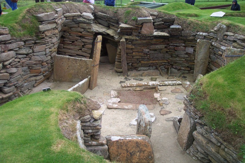
The ordinary houses repeat the same room: a dresser stands opposite the low door, a larger bed lies on the right, a smaller bed lies on the left, and a hearth sits in the middle. Drains run under some of the floors. The people kept cattle, pigs, and sheep, grew barley, and ate fish, and stone tanks may have held limpet bait. House 8, standing alone with walls over two metres thick and no dresser, may have been a workshop.
The end of the village is told in two ways. One picture is a sudden flight from the sand, with ornaments and joints of meat left behind. The other is a slow burial after the people had already gone, for a reason that cannot now be named. A low road leaves Skara Brae, passes near both stone circles, and ends at Maeshowe.
Colin Richards found the Barnhouse Settlement beside the Loch of Harray in 1984. At least fifteen houses there date to around 3000 BC and were abandoned around 2600 BC. They share hearths, beds, and dressers with early Skara Brae, but they stood free of one another. After the houses were left, Structure 8 was built with thick walls and an entrance aligned on the midsummer sunset and on Maeshowe.
The Stones of Stenness may be the oldest henge in the British Isles, and work there had begun by 3100 BC. Four slabs remain from a circle of up to twelve, set in an ellipse about thirty-two metres across. Their height is given both as up to about five metres and as up to six metres. The holed Odin Stone, used for engagements and other oaths, was smashed in December 1814 by Captain Mackay, and a stone he toppled was put back in 1906.
Maeshowe was probably built around 2800 BC, though burials in similar tombs cluster nearer 3000 BC. The mound is about thirty-five metres across, and a low passage leads into a square chamber of flagstone, some slabs weighing thirty tons. For a few days around the winter solstice the setting sun reaches the back wall. Estimates of the labour are about 39,000 hours and at least 100,000 hours, and no human remains were found in the chamber.
In the twelfth century Norse visitors broke in through the roof and cut about thirty-three runic inscriptions into the walls. One boasts of the most skilled rune-cutter west of the ocean, and another says that Ingigerth is the most beautiful of women. A medieval account has Harald Maddadsson and Rognvald, Earl of More, shelter in the mound during a snowstorm and break in for treasure. James Farrer emptied the chamber again in July 1861 and found the runes still there.
The Ring of Brodgar stands on the isthmus between the two lochs and is an almost perfect circle. Its size is given as 104 metres in diameter and also as 130 metres across. Up to sixty stones once stood there, twenty-seven were still standing at the end of the twentieth century, and another figure says thirty-six survive. The ring is generally placed between 2500 and 2000 BC, inside a ditch cut into the sandstone.
The Ness of Brodgar, between the circles, is a mound of stone buildings dug under Nick Card from 2003 until the trenches were reburied in 2024. It is not one of the four inscribed monuments, though it lies in the buffer around them. Structure 10 was closed between about 2400 and 2200 BC after a feast that left the shin bones of about four hundred cattle. In August 2023 a wooden plank, a rare survival in acidic soil, was found in Structure 27, and radar in 2025 showed an anomaly unlike the rectangular buildings, to be tested by a small excavation in July 2026.
In the same year, 2023, a ruined Maeshowe-type cairn at Holm yielded fourteen articulated skeletons of men, women, and children. Maeshowe itself still had none. In April 2019 the Climate Vulnerability Index was used here for the first time on a cultural property of this kind. The study found the whole group, and Skara Brae in particular, extremely vulnerable to rising seas, heavier rain, and one unusually severe storm.
Later stone work on the islands took other forms. The Dwarfie Stane on Hoy is a tomb cut into a single block, and Burroughston Broch on Shapinsay is an Iron Age roundhouse opened around 1862, soon after Maeshowe. The World Heritage Committee has also inscribed places of wholly different ages, including Canterbury Cathedral and Derwent Valley Mills. Those names mark the breadth of the list, and they are not neighbours in time of the farmers who set a dresser opposite the door and aimed a passage at the winter sun.
Images




Detailed History
The Heart of Neolithic Orkney is a group of stone monuments on Mainland, the largest of the Orkney Islands. Four of them carry the name: the village of Skara Brae on the Bay of Skaill, the chambered cairn of Maeshowe, the Stones of Stenness, and the Ring of Brodgar. They stand in two areas about 6.6 kilometres apart. Around them lie other stones and unexcavated burial, ceremonial, and settlement places, including the Barnhouse Stone and the Watch Stone.
Together they show domestic life, burial, and ceremony among farming communities in this northern archipelago about five thousand years ago.
The Orkney Islands lie about 15 kilometres north of the Scottish coast, across a short stretch of sea from Caithness, and about 10 miles from that shore in another reckoning. About seventy islands make up the archipelago, of which about twenty are inhabited. Mainland covers about 523 square kilometres. Kirkwall is the largest settlement and the administrative centre.
The sandstone can be split into flat slabs, the wind-blown sand has buried and kept some ancient buildings, and a relatively light history of ploughing and industry has left many monuments standing. The designated ground of the four monuments covers about 15 hectares, with a buffer of about 6,258 hectares. A small change to the boundary was made in 2015. The World Heritage Committee inscribed the group on 2 December 1999.
Prehistoric Orkney, in the sense used for the islands’ human past, runs from the first occupation until about AD 600, the start of the early historic period in this part of Scotland. For much of the last glacial period the British-Irish ice sheet covered the islands, and no trace has been found of archaic humans in the early or middle Palaeolithic. Late Upper Palaeolithic stone tools of Ahrensburgian type have been found on Stronsay and at Brodgar, which suggests people were here around or before 8000 BC, perhaps as early as 11,000 BC, while Britain was still joined to the continent by Doggerland. Those first visitors were mobile hunter-gatherers who may have come only now and then.
By 8000 BC rising seas had divided the land into two islands, and by 6000 BC the archipelago looked broadly as it does now. Hazel, birch, and willow grew here, with some Scots pine. A charred hazelnut shell from Longhowe in Tankerness has been dated to 6820–6660 BC. The Mesolithic record is otherwise thin: small stone tools and chippings from places such as Seatter, Wideford Hill, and the Loch of Stenness, and no clear sign of year-round settlement.
The islands’ recorded name is much later than the monuments. Pytheas of Massalia, probably between 322 and 285 BC, described a northern tip of Britain called Orcas. Roman geographers, including Ptolemy and Pomponius Mela, called the islands the Orcades, and Tacitus claimed that his father-in-law Agricola had discovered and subjugated them, although Mela and Pliny had already referred to the islands. The element orc has usually been taken as a Pictish tribal name meaning young pig or young boar.
Norse settlers from the late ninth century heard it as the word for seal and added their word for islands, so the name became the seal islands, later shortened in English to Orkney. The Kingdom of Norway colonised and then annexed the islands in 875. In 1472 the Parliament of Scotland absorbed the Earldom of Orkney after the family of Margaret of Denmark failed to pay the dowry promised to James III. That long political afterlife belongs to the Orkney Islands as a whole.
The people who raised the four monuments lived millennia earlier, in a world of cattle, barley, and stone, with no written names of their own.
Farming had spread through northwest Europe from before 4000 BC. On Papa Westray, the stone farmstead at Knap of Howar dates from about 3500 BC to 3100 BC and is thought to be the oldest preserved standing building in northern Europe. Its houses resemble the later ones at Skara Brae, but they belong to an earlier generation. The pottery of that earlier world is Unstan ware, named after the Unstan chambered cairn on Mainland, where it was found in 1884.
Typical pieces are shallow bowls with a band of stab-and-drag grooves under the rim, or plain round-bottomed bowls, sometimes gritted with volcanic rock and burnished with bone tools. Unstan ware is mostly found in Orkney-Cromarty stalled tombs, including the Tomb of the Eagles on South Ronaldsay and Midhowe and Taversoe Tuick on Rousay, though it also turns up in houses, including Knap of Howar. One view is that this style evolved into the later Grooved ware. D.
V. Clarke argued that his work at Rinyo on Rousay had undone that simple sequence. John Hedges has instead argued that the two traditions lived side by side for centuries, with no deep difference in the social life of the people, only in parts of their material culture, under a wider unity that took in the whole of Orkney.
Grooved ware seems to have developed in Orkney early in the third millennium BC and then spread across Britain and Ireland. The typical pot is flat-bottomed, with sides sloping out and grooves around the top. Some pots carry complex geometry, and some have applied bands of clay, which has led to the idea that the style copies basketry. Pots range from cup size to very large vessels.
Stuart Piggott had earlier called the style Rinyo-Clacton ware, after Rousay and a site at Clacton now under the sea. The earliest examples are Orcadian, and finely decorated sherds, including very large pots and drinking vessels, have been found at the Ness of Brodgar. The same pottery was used by the builders of the first phase of Stonehenge, and it is abundant at Durrington Walls and Marden, where feasting involved pork. In that sense the islands were not a backwater that received a southern idea.
A style made here travelled south. What was at stake in that spread is still argued. Shared pots did not mean shared customs, and regions that used Grooved ware kept very different traditions. Trade along the west coast, including Cumbrian stone axes reaching Orkney, is one route that has been suggested.
Skara Brae sits in the sand at the Bay of Skaill, on the west coast of Mainland. The name joins a Scots word for a slope with an older name, Skerrabra or Styerrabrae, for the grassy mound that hid the houses. In the winter of 1850 a severe storm, which killed more than two hundred people across Scotland, stripped the mound. Villagers saw the outlines of small roofless houses.
William Graham Watt of Skaill House, a son of the local laird and a self-taught geologist, began an amateur excavation. After four houses had been uncovered, the work stopped in 1868. In 1913 a party with shovels plundered the site over a single weekend and took away an unknown quantity of objects. In 1924 another storm tore away part of a house, the one later called House 3, which had already been damaged.
That year the site was taken into state care. A sea wall was begun in 1925. Clearance for public view started in 1927 under J. Wilson Paterson, and V.
Gordon Childe, newly arrived as Abercromby Professor of Archaeology at Edinburgh, came to the site in the middle of that year and directed the excavation.
Childe was born in Sydney on 14 April 1892 and died on 19 October 1957. From 1927 to 1946 he held the Edinburgh chair, and his Scottish work centred on Neolithic Orkney, at Skara Brae and at the chambered tombs of Maeshowe and Quoyness. When he dug, no Neolithic houses were known in Orkney, and the nearest comparisons were Iron Age brochs. Carved stone balls were widely treated as Pictish because of where they occur.
Graham Callander argued hard for an Iron Age date, and Childe’s 1931 account still presented a Pictish village. He had thought the settlement belonged around 500 BC. Excavations in 1972 and 1973 by David Clarke and Anna Ritchie, and the radiocarbon dates from them, placed the occupation in the Neolithic. A set of photographs re-examined in 2019 shows Childe with four women who had been described as tourists or local visitors.
A note on the back calls them four of his women students, and they seem to have taken part in the dig. They have been tentatively identified as Margaret Simpson, who was thanked in his Skara Brae monographs, Margaret Mitchell, Mary Kennedy, and Margaret Cole.
The dates of the village are given in more than one span, and both should be kept. One account places occupation from roughly 3180 BC to about 2500 BC, a run of about six centuries. A modelled chronology is finer. An early phase, called Phase 0 by Clarke and Shepherd, used pottery that was probably round-based and falls sometime between 3360 and 3160 BC.
The earliest houses that still survive, Phase 1, belong to the early third millennium, with ranges given as 2920–2850 BC down to 2870–2760 BC, and also as beginning in 2920–2885 BC. That occupation may have lasted less than a century, perhaps only about fifty years, before the place was abandoned around 2870–2760 BC, probably under a blow of sand. People returned, rebuilt, and remodelled houses, including an early version of House 7, within 2840–2685 BC, and stayed until 2545–2440 BC. Cereal growing seems to have stopped after the early, pre-Grooved Ware phase.
After the final abandonment there are hints of brief later use, including the Iron Age. At least twenty-eight structures have been recorded. Ten buildings and four passageways can be seen today. An unknown number were lost to the sea before 1850.
When the place was first lived in, the coast lay about half a kilometre to the west. It now stands at the edge of the shore.
The houses were free-standing stone buildings, later packed and insulated with midden, not an underground village as was once thought. In the later phase some passages were roofed with slabs, clay, and turf. Each of the ordinary houses is a single room of roughly forty square metres, entered by a low door that could be closed with a bar of bone sliding in holes cut in the jambs. Seven houses repeat the same furniture.
A dresser stands opposite the door, so it is the first thing a person sees. A larger bed lies on the right of the doorway and a smaller bed on the left. Lloyd Laing noted that this matches a Hebridean habit, still known in the early twentieth century, in which the larger bed was the husband’s, and beads and paint pots in some of the smaller beds may support that reading. Stone boxes, perhaps for limpet bait, sit so that someone coming in turns toward the right-hand side.
Drains run under at least five houses. The central hearth is a constant. Childe was sure the fuel was peat, but thick peat may not have formed in this part of Orkney until after the village was left. Driftwood, animal dung, and dried seaweed are other possibilities, and a glassy slag sometimes called kelp or cramp may be burnt seaweed.
House 8 has no dresser and no storage boxes. It is divided into small cubicles, stands alone with walls over two metres thick and a porch, and held fragments of stone, bone, and antler, heat-damaged volcanic rock, and what looks like a flue. It may have been a workshop for bone needles and flint axes. A larger building at one end of the village, with a special hearth and no box-beds, may also have been a workshop.
The people kept cattle, pigs, and sheep. Childe thought they did not farm, but seed grain from a midden, found in 1972, shows that barley was grown. Fish bones and shells are common, and limpet shells may be the remains of bait kept in clay-sealed stone tanks. The site has produced the earliest known record of the human flea in Europe.
Carved stone balls carry spiral ornament that has been compared with the Boyne Valley in Ireland, and similar marks were cut on lintels and bed posts. Red ochre may have been used for body paint. Polished haematite nodules may have finished leather. Pottery jars of up to thirty litres were found in the houses.
Tools and ornaments were made of animal, fish, bird, and whale bone, of whale and walrus ivory, and of orca teeth: awls, needles, knives, beads, adzes, shovels, small bowls, and ivory pins up to twenty-five centimetres long, again with parallels in the Boyne passage graves. The Skaill knife, a large flake struck from a sandstone cobble, is named from this bay and turns up across Orkney and Shetland. Waterlogged layers reached in 1972 kept a twisted skein of heather, one of the very few pieces of Neolithic rope known, and a wooden handle. In 2016 a carved whalebone figurine called the Skara Brae Buddo was found again in a box at Stromness Museum.
It is thought to be about five thousand years old, with four holes placed like eyes, a mouth, and a navel, and it had been known from a nineteenth-century sketch by the antiquary George Petrie. Under the eastern wall behind a box-bed in House 7, a cist held the remains of two women.
Why the village ended is disputed, and the two readings should both be kept. One picture, pressed by Evan Hadingham, is a flight like Pompeii: necklaces of teeth and bone, walrus-ivory pins, and joints of meat left in the beds, and a broken string of beads scattered in a passage as someone squeezed out ahead of the sand. Anna Ritchie rejects that catastrophe. Burial in sand was gradual, she argues, and the people had already gone, for a reason nobody can now name.
The houses that remain give an impression of one planned whole, but more buildings may already have vanished to the sea, and further remains are known under the fields inland and in the cliff a little to the south. Euan MacKie suggested that the village housed a privileged class of wise men who performed astronomical and magical rites at the Ring of Brodgar and the Stones of Stenness. Graham and Anna Ritchie found no archaeological evidence for that claim. There is, though, a Neolithic low road that leaves Skara Brae, passes near both circles, and ends at Maeshowe.
Low roads link ceremonial places across Britain.
The Barnhouse Settlement, found by Colin Richards in 1984 and excavated from 1986 to 1991, stands by the Loch of Harray near the Stones of Stenness. At least fifteen houses survive as base courses. They share central hearths, wall beds, dressers, and drains with the early phase at Skara Brae, but they seem to have stood free. The settlement dates to around 3000 BC and was abandoned around 2600 BC.
Grooved ware, flint, and stone tools were found, and a piece of pitchstone thought to come from Arran. House 2 was double-sized, built to a higher standard, rebuilt as many as five times, and used throughout. The houses clustered on an open area divided between potting and the working of flint, bone, and hides. After the houses were left, Structure 8 was built partly over them: a room about seven metres square, walls about three metres thick, on a clay platform, with an entrance aligned so that the midsummer sunset shines along the passage, and an outer entrance aligned on Maeshowe.
It is taken to be ceremonial rather than a house, and closely tied to the Stones of Stenness. Some of its hearth slabs may have been moved to the circle.
The Stones of Stenness may be the oldest henge in the British Isles. The name is Old Norse for a stone headland, and in local speech it is pronounced stane-is. The stones stand on a promontory at the south end of the stream that joins the Loch of Stenness, which is brackish, to the freshwater Loch of Harray. The Ring of Brodgar lies about 1.2 kilometres to the north-west, and Maeshowe about 1.2 kilometres to the east.
Four thin slabs remain from a circle of up to twelve, set in an ellipse about thirty-two metres across on a levelled platform about forty-four metres across. Their height is given both as up to about five metres and as up to six metres. The ditch, now filled and no longer obvious on the surface, was cut into rock by as much as two metres and is about seven metres wide, with an earth bank and a single entrance causeway on the north, facing Barnhouse. The Watch Stone, outside the circle to the north-west, is 5.6 metres high.
A second stone once stood near it; its stump was found in the 1930s. In the centre, a square stone setting held cremated bone, charcoal, and pottery, and is called a hearth, like the one at Barnhouse. Animal bone lay in the ditch. The pottery links the monument to Skara Brae and Maeshowe.
Radiocarbon dates suggest work had begun by 3100 BC.
Even in the eighteenth century the stones were tied to rites that people by then explained through Norse gods. The Odin Stone, in the field north of the henge, had a round hole. Couples plighted engagements by holding hands through it, and other oaths taken with a hand in the hole were called the Vow of Odin. Walter Scott visited in 1814.
In December of that year Captain W. Mackay, a recent arrival who farmed nearby, began to destroy the stones because people were trespassing on his land to use them. He smashed the Odin Stone, destroyed another, and toppled a third before outrage stopped him. The toppled stone was put back in 1906, along with some inaccurate reconstruction inside the circle.
A dolmen that had been set up there was toppled again in the 1970s because its authenticity was in doubt. Two uprights from that arrangement remain. Young people were also said to have made vows at the Ring of Brodgar and the Stones of Stenness, treated in local legend as temples of the sun and the moon, and at the Odin Stone. Sigurd Towrie has suggested that those temple names were romantic labels added by antiquaries of the eighteenth or nineteenth century, in the same spirit as a druid’s circle or a sacrificial altar.
Maeshowe, called Orkahaugr in Old Norse, is a chambered cairn and passage grave, probably built around 2800 BC, though burials from similar tombs cluster nearer 3000 BC. The modern name comes later. Howe is the Norse word for a mound. The first element is less certain: it may be a worn form of the Norse name, or, as Hugh Marwick suggested with some doubt, a Gaelic word for a rounded hillock.
The grass mound is about thirty-five metres across and 7.3 metres high, with a ditch roughly fifteen to twenty-one metres out from the base and up to fourteen metres wide. The passage and chamber are built of local flagstone slabs, some weighing as much as thirty tons. The passage is about eleven metres long and only about 0.91 metres high, so a person must stoop or crawl, and it opens into a chamber about 4.6 metres on each side. The surviving stonework stands about 3.8 metres high under a modern corbelled roof; the original roof may have risen to about 4.6 metres or more.
From about 0.91 metres up, the walls change from upright slabs to overlapping courses and a beehive vault, with massive angled buttresses in the corners. Stuart Piggott called it a superlative monument that its originality lifts out of its class into a unique position. Estimates of the labour differ: one figure is about 39,000 hours, and Colin Renfrew calculated at least 100,000 hours. Either figure means a community large enough, and agreed enough, to move stone on that scale.
The passage is aligned so that, for a few days on either side of the winter solstice, the setting sun shines onto the back wall of the chamber and toward the rear cell. A similar midwinter effect is known at Newgrange. The Barnhouse Stone, in a field about seven hundred metres away, lines up with the entrance. The land around the cairn at the time of building was probably already treeless, with grasses that point to mixed farming and a pastoral bias, including ribwort and cereals.
Maeshowe gives its name to a type of chambered cairn limited to Orkney: a long low passage into a square or rectangular chamber with side cells. Counts of the type do not agree. Seven are treated as definite: Maeshowe, Cuween Hill, Wideford Hill, and Quanterness on Mainland, Quoyness on Sanday, Vinquoy Hill on Eday, and an unnamed tomb on the Holm of Papa Westray. Anna Ritchie reports three more that she does not name.
Another count says only twelve Maeshowe-type cairns are known in Orkney. Grave goods and human remains are known from some of the others. None were found in Maeshowe itself. Peter Tompkins, drawing on Alexander Thom, argued in 1971 that the building was an observatory and calendar, with side rooms for watchers, rather than a tomb.
That reading is not the one used by the excavators who treat it as a passage grave that happens to have held no surviving burial.
The mound did not stay sealed. In the twelfth century Norse visitors broke in through the roof rather than along the passage, some four thousand years after it was built. They cut more than thirty runic inscriptions into the walls, about thirty-three in all, by several hands, the largest collection of runes known from a single place. The carvings read as graffiti.
One boasts that the runes were carved by the man most skilled in runes west of the ocean. Another says that Ingigerth is the most beautiful of women. Many simply leave names. The Orkneyinga saga, which calls the mound Orkahaugr, tells of a party led by Harald Maddadsson and Rognvald, Earl of More, caught in a snowstorm, sheltering in the mound, and later breaking into the chamber for treasure.
The saga mixes history and legend, but the story fits the archaeological signs of a twelfth-century entry. Earl Harald Maddadsson, who lived from about 1134 to 1206, ruled jointly for a time with Earl Rognvald. By 1158 he was the undisputed Earl of Orkney, after King David I had died, King Eystein had died in a war with his brothers, and Harald’s cousin Erlend Haraldsson had been killed in 1154. The saga was first written down in the early thirteenth century, around the time of Harald’s death, and its early chapters, including the voyage of Harald Fairhair and Rognvald Eysteinsson of Møre, are much less secure as history than its later ones.
Norse stories of mounds often put treasure inside them, guarded by the restless dead. When antiquaries came back in the nineteenth century the runes were still on the walls. The external wall around the ditch was rebuilt in the ninth century, which some archaeologists take as a sign that Norse people reused the tomb and that they were the source of whatever later looters hoped to find.
James Farrer, Member of Parliament for South Durham, opened the tomb again in July 1861. He and his workmen broke through the roof of the passage, found it full of debris, then broke through the top of the mound and, over a few days, emptied the chamber, which had been filled completely. They found the runes, proof that Norsemen had been inside at least six centuries earlier. John Hedges later judged Farrer to have had a hunger for digging matched by crude technique and a failure to publish.
Reflectance transformation imaging has since been used to record the runes and the order in which they were cut. George Petrie, who noted the structures, was also directing estate workers of Colonel D. Balfour at Burroughston Broch on Shapinsay around 1862, shortly after Maeshowe was opened, with Sir Henry Dryden drawing a plan. That broch is a later monument, not part of the Neolithic group, but it shows how quickly, once Maeshowe was news, Orcadian stone buildings of other ages were opened with the same antiquarian energy.
The Ring of Brodgar stands on the narrow isthmus between the Loch of Stenness and the Loch of Harray, about six miles or about ten kilometres north-east of Stromness. It is the only major henge and stone circle in Britain that is an almost perfect circle, and it ranks with Avebury and Stonehenge among the greatest circles, though it is the northernmost circle-henge. The diameter is given as 104 metres, and the circle is also described as 130 metres across. It is the third largest stone circle in the British Isles.
There were originally up to sixty stones. Twenty-seven were still standing at the end of the twentieth century, and another figure says thirty-six stones survive. The tallest stand on the south and west. The Comet Stone lies to the south-east, and thirteen Neolithic and Bronze Age mounds sit around the ring.
The stones stand in a ditch cut into solid sandstone, up to three metres deep, given both as nine metres wide and as ten metres wide, and about 380 metres in circumference. One estimate puts the labour at 80,000 hours. There is no clear outer bank, so the ditch is not, strictly, a true henge, yet many archaeologists still use that word. Aubrey Burl treats it as a henge with two opposed entrances, on the north-west and south-east.
The ditch seems to have been dug in sections, perhaps by gangs from different parts of Orkney, and the stones may have been added later, over a long time. Nothing obvious stands inside the circle, but the interior has never been fully excavated, so timber settings are not ruled out.
The age of the ring has resisted dating. It is generally placed between 2500 BC and 2000 BC, and is thought to be the last of the great Neolithic monuments on the Ness. An excavation in the summer of 2008 tried to settle the question; the results remain preliminary. Within about two square miles, or about five square kilometres, there are two circle-henges, four chambered tombs, standing stones, barrows, cairns, and mounds, and flint arrowheads and broken mace-heads that seem to be Bronze Age.
Captain Frederick Thomas of the Royal Navy, surveying for the Admiralty from the cutter Woodlark in 1848 and 1849, made the first formal survey of the ring and its neighbours. It was published in 1852. Several stones carry Norse runes, including the name Bjorn, a small cross, and an anvil. Alexander Thom argued for a common megalithic yard and for the ring and its mounds as backsights for watching the moon.
Douglas Heggie found little evidence for so precise a unit. Graham Ritchie noted that the mounds are not reliably dated and doubted the astronomical skill claimed for the builders. The same caution falls on MacKie’s wise men at Skara Brae. The low road remains the firmest link between the village and the circles and the cairn.
Between the two circles, on the Ness of Brodgar, a peninsula of about two and a half hectares in one measure and about three hectares in another, a mound some 250 metres by 100 metres and over four metres high covers a dense group of stone buildings. A geophysical survey in 2002, made as part of work on the wider monumental landscape, showed unexpected anomalies. In 2003 a notched slab turned up in ploughing, and the find-spot proved to be a building. Nick Card led excavations for the Orkney Research Centre for Archaeology at the UHI Archaeology Institute, with trial trenches from 2004 to 2008 and summer digging from 2009 until 2024, involving archaeologists from Orkney College and from the universities of Aberdeen, Cardiff, and Glasgow.
For the rest of each year the trenches were covered with plastic and tyres. The stone had begun to flake in the air, and reburial started on 16 August 2024 and was almost finished by 27 September. The Ness is not one of the four inscribed monuments. It lies in the buffer around them, in both the original boundary and the boundary modified in 2015, and it has been described both as inside that wider designated landscape and as outside the inscribed site itself.
Either way, it has changed what the four monuments can be understood to mean. People from Skara Brae could have walked there, taken part in whatever was happening, and walked home in a day.
Activity on the Ness is placed as early as about 3500–3400 BC, with the main buildings around 3000 BC, and the place seems to have been closed and partly dismantled by 2200 BC. Another span puts the buildings in waves from roughly 3500 BC to 2400 BC. About forty structures were uncovered in the long excavation. The ones still discussed as the main sequence include Structures 1, 5, 8, 10, 12, 14, 26, and 27, with many earlier buildings demolished underneath them.
They are of flagstone. Some slabs are too thin for floors or walls and are read as the earliest evidence of stone roofs. Structure 5, begun around 3300 BC over an older building, is the largest non-funerary Early Neolithic construction known in Orkney, a long boat-shaped room, once lined with furnishings like the Skara Brae dressers, later extended, and then partly taken down, with the timber roof posts pulled out carefully and objects dropped into the post-holes. Structure 1, first built around 3100 BC, was more than fifteen metres long, shaped like a double cross, with two hearths and two doors, and was rebuilt within about a century and again about two hundred years after it began.
It carries more than seventy pieces of Neolithic art. Some stones were painted yellow, red, and orange with ochre made from haematite mixed with animal fat, milk, or eggs, the earliest evidence in Britain that Neolithic people painted their buildings. In 2015 the bones of a baby who died around the time of birth were found in a recess there.
Structure 10, built around 2900 BC on the rubble of earlier walls and partly rebuilt around 2800 BC, is the largest building of its kind in the north of Britain. It was used until about 2400–2200 BC and then closed in a single ceremonial episode. The shin bones of about four hundred cattle, most of them cracked for marrow, were laid around it, an upturned cow skull was placed inside, and the carcasses of several red deer were set on top of the broken bones before the building was largely destroyed. In 2013 an intricately inscribed stone, cut on both sides and called potentially the finest piece of Neolithic art found in Britain for several decades, came out of Structure 10, and a few days later a carved stone ball was found in place, a rare thing in a modern excavation.
Six further carved stone balls of camptonite from the site are held in the Orkney Museum. A great wall, perhaps a hundred metres long and six metres wide or more, may have crossed the whole peninsula as a symbolic barrier between the ritual ground of the Ring and the ordinary world beyond it. Another wall, perhaps even larger, was found later. Decoration on the stones includes scratching, carving, pick dressing, painting, and cup marks.
A baked clay figurine known as the Brodgar Boy, with a head, a body, and two eyes, was found in two pieces in the rubble of Structure 14 in 2011.
Structure 27, which may be contemporary with Structure 10 and so first built around 2900 BC, stood outside the southern boundary wall. It was about seventeen metres by eleven, with curved walls of unusually fine masonry, a central hearth with only a thin layer of ash, stone furniture, a drain, and a stone-tiled roof. In the rubble inside it, in August 2023, excavators found a sizeable plank of wood. Organic material almost never survives in the acidic soil.
The finds supervisor, Anne, called the plank the most exciting find from the site. Whether the wood was a species that grew in Neolithic Orkney or a piece of driftwood was left for later study. Cattle bone, and one otter bone, lay under an orthostat at the building’s north-west corner, in the same spirit as the deposits around Structure 10. The building was formally dismantled, and later stone robbers took parts of the south-eastern and south-western walls.
Digging stopped in 2024 with the buildings covered again for their preservation. In the summer of 2025 a form of ground-penetrating radar not previously used in Scotland produced the first three-dimensional images of the whole Ness. The survey showed an anomaly the team called totally unlike anything else on a site otherwise defined by straight lines and rectangles, from the architecture down to the art. Nick Card, who had worked there from 2004, said it might add a new chapter, that it lay where there did not seem to be deep archaeology, and that it might not be Neolithic at all, though it could be of the same age.
He described the next step as keyhole surgery: a small trench, not another twenty years of open excavation. That dig is planned for four weeks in July 2026, on weekdays from 7 July to 30 July, and it will be open to visitors. The buildings uncovered before 2024 will stay covered. The team has not said what they believe the anomaly to be.
A related discovery, not at Maeshowe itself, sharpened the picture of the tomb type in 2023. In August and September, excavation in the East Mainland parish of Holm uncovered a Maeshowe-type cairn that had been largely destroyed without record in the nineteenth century. Hugo Anderson-Whymark and Vicki Cummings directed the work. The cairn was over fifteen metres across, with a chamber reached by a passage seven metres long and six smaller side cells that once had corbelled roofs.
In one side cell lay fourteen articulated skeletons of men, women, and children, with other scattered bones. Pottery, stone tools, and a bone pin came from the Victorian backfill. Very few Orcadian chambered cairns have been found with human remains, and those that have were mostly dug in the nineteenth or early twentieth century. The Holm bodies can now be studied for health, origin, and kinship.
Maeshowe itself still has no burial.
The four monuments were approximately contemporary with the mastaba tombs of the early Egyptian dynasties, the brick temples of Sumer, and the first cities of the Harappan tradition, and a century or two earlier than the period sometimes called the golden age of China. What they changed is the evidence, not a written constitution. They show that communities on the edge of the Atlantic, in the late fourth and third millennia BC, could quarry, haul, and fit flagstone, organise tens of thousands of hours of shared work, align a passage on the winter sun, and furnish a house with the same dresser and beds as the neighbour’s house. The concentration of tombs, circles, and settlements on central Mainland is rivalled in Britain only by the landscapes of Stonehenge and Avebury.
Grooved ware carried motifs from the Ness, including the so-called eyebrow and the Brodgar butterfly, southward. The islands later passed through a Bronze Age that left fewer monuments, then an Iron Age that built brochs again at a monumental scale. Prehistoric Orkney, as a frame, includes that whole run.
On Hoy, the Dwarfie Stane is a chamber cut into a single block of Devonian Old Red Sandstone, a glacial erratic in a steep valley between Quoys and Rackwick. It is the only chambered tomb in Orkney cut from living rock rather than built of stones, and it may be the only Neolithic rock-cut tomb in Britain. The block is 8.6 metres long, 4 metres wide, and up to 2.5 metres high. A square entrance on the west leads to a passage 2.2 metres long and two side cells, one of them with an uncut pillow of rock.
The plan matches the Orkney-Cromarty tombs even so. A blocking slab now lies in front of the door. The chamber was robbed through a hole in the roof, already noted by the sixteenth century and patched with concrete in the 1950s or 1960s. Local legend gave the stone to a dwarf named Trollid, and also, by a contrary story, to giants.
Walter Scott made it widely known in his novel The Pirate, published in 1821. In 1850 Captain William Mounsey camped there and cut a Persian inscription, “I have sat two nights and so learnt patience,” with his name written backwards in Latin above it. Hugh Miller, a stonemason as well as a writer, described the sandstone as extremely compact, which may be why a rock-cut tomb was tried once and not repeated. There is no direct evidence linking it to the rock-cut tombs of the Mediterranean, despite the resemblance.
Burroughston Broch, on the north-east shore of Shapinsay, belongs to the Iron Age return to monumental roundhouses. The walls are up to four metres thick, about eighteen metres across on the outside and about ten metres inside. From the outside it is a grassy mound. The entrance passage, on the east, is about four metres long, with a guard cell opening on the left.
A well in the floor is lined with dry stone and then cut into the rock. Traces of outbuildings, and of a wall, ditch, and rampart, survive in front. Petrie’s dig in about 1862 was limited to the interior and a small area outside the door. He reported mostly fragments of deer horn, many ox and sheep bones, and several rough stone vessels, including a possible triangular lamp.
Little else is known of the finds. The broch is one of the best preserved in Orkney, and it stands as the later chapter of an island tradition that had already, at Maeshowe and the circles, spent enormous labour on buildings for the dead and for gatherings.
The same century that opened Maeshowe and Burroughston Broch also fixed the circles in antiquarian drawings. The twentieth century dated them, and argued over wise men, lunar backsights, and a shared yard. The twenty-first century uncovered the buildings on the Ness and then covered them again. In April 2019 the Climate Vulnerability Index was applied here, the first time that assessment had been used on a cultural property of this kind.
The study found the whole group, and Skara Brae in particular, extremely vulnerable, because of rising sea levels, heavier rain, and other changes. It warned that one unusually severe storm could partly destroy Skara Brae. The sea wall, extended and consolidated from 1963 and repaired again up to work finished in 2011, is itself being undermined as the beach drops. Coastal erosion was already under way while the village was lived in.
Visitor footfall is the other physical threat, and the path inside the Ring of Brodgar has had to be closed for periods so that worn ground can recover. The open, almost treeless bowl of ridgelines, from Hoy across to the hills, is what makes the alignments between the monuments readable. That openness is also fragile.
The World Heritage Committee is the body that selects places for the world list. It is drawn from twenty-one states, elected for a term that the convention sets at six years and that many states voluntarily cut to four. It meets once a year, and three advisory bodies assist its deliberations. Each member state has one vote.
The committee has been criticised for politicising new inscriptions, and an external audit in 2011 found that political considerations were influencing decisions and that diplomats had replaced specialists among the representatives. Those arguments are about the list as a whole. For this landscape, the decision of 2 December 1999 recognised a group that shows a significant stage of human history, the age when the first large ceremonial monuments were built, and a tradition that flourished between about 3000 BC and 2000 BC. Other places in Britain have been inscribed by the same process and are not part of this Neolithic story.
Canterbury Cathedral, the seat of the archbishop and part of a larger inscribed group with St Augustine’s Abbey and St Martin’s Church, was founded in 597 by Augustine, sent by Pope Gregory I, and was rebuilt after a fire in 1174 around the pilgrimage to Thomas Becket, murdered in the church in 1170. Derwent Valley Mills, designated in December 2001, is the valley where Richard Arkwright applied water power to cotton spinning in the 1770s, at Cromford and then at mills copied through the valley, with workers’ housing, schools, and chapels. By 1788 there were more than two hundred Arkwright-type mills in Britain. The cotton trade later shifted toward Lancashire.
Naming those places only marks the breadth of the list. It does not make them neighbours in time of Skara Brae or Maeshowe.
What remains on Mainland is a domestic interior, a tomb aligned on midwinter, and two circles set between lochs, plus a buried complex between the circles that was lived in, painted, feasted over, and then deliberately closed. The people are unnamed. The events that can be tied to persons come later: Watt in the sand after the storm of 1850, Childe and his students in the late 1920s, Farrer in the chamber in 1861, Mackay and the Odin Stone in 1814, Harald Maddadsson and the rune-cutters in the twelfth century, Nick Card and the crews on the Ness from 2003 to 2024, and the radar crew of 2025. The stake now is whether the sand, the sea, and the feet of visitors leave the stone where those people, and the unnamed farmers before them, put it.
Sources
- Heart of Neolithic Orkney — Wikipedia
- Skara Brae — Wikipedia
- Maeshowe — Wikipedia
- Ring of Brodgar — Wikipedia
- Standing Stones of Stenness — Wikipedia
- Ness of Brodgar — Wikipedia
- Prehistoric Orkney — Wikipedia
- Orkney — Wikipedia
- Barnhouse Settlement — Wikipedia
- Grooved ware — Wikipedia
- Unstan ware — Wikipedia
- Dwarfie Stane — Wikipedia
- Burroughston Broch — Wikipedia
- World Heritage Committee — Wikipedia
- Climate Vulnerability Index — Wikipedia
- Canterbury Cathedral — Wikipedia
- Derwent Valley Mills — Wikipedia
- V. Gordon Childe — Wikipedia
- Orkneyinga saga — Wikipedia
- Heart of Neolithic Orkney — UNESCO World Heritage Centre
- Heart of Neolithic Orkney — Historic Environment Scotland
- Skara Brae — Historic Environment Scotland
- Plan your visit, Skara Brae — Historic Environment Scotland
- History and stories, Skara Brae — Historic Environment Scotland
- Maeshowe Chambered Cairn — Historic Environment Scotland
- Plan your visit, Maeshowe — Historic Environment Scotland
- The Story of Skara Brae — Historic Environment Scotland
- Skara Brae Statement of Significance — Historic Environment Scotland
- Extraordinary discovery at Orkney Neolithic site — BBC News
- Dig Diary, 9 August 2023 — Ness of Brodgar Project
- Lost Neolithic chambered cairn unearthed in Orkney East Mainland — Archaeology Orkney
- Orkney Skara Brae.jpg — Wikimedia Commons
- MapNeolithicHeart.gif — Wikimedia Commons
- Ancient house at Liddle - geograph.org.uk - 54648.jpg — Wikimedia Commons
- Brough of Deerness - geograph.org.uk - 491356.jpg — Wikimedia Commons
- Megawal58.jpg — Wikimedia Commons
- Liddle Burnt Mound 2017 02.jpg — Wikimedia Commons
- Liddle Burnt Mound 2017 01.jpg — Wikimedia Commons
- Liddle Burnt Mound 2017 03.jpg — Wikimedia Commons
- Chapel on the Brough of Deerness, remains 2014.jpg — Wikimedia Commons
- Bronze Age House at Liddel Farm - geograph.org.uk - 1997717.jpg — Wikimedia Commons