
Settlement · Fortification
Dunollie Castle
small ruin located north of the town of Oban, Scotland

Argyll and Bute, United Kingdom · 1300 CE · United Kingdom
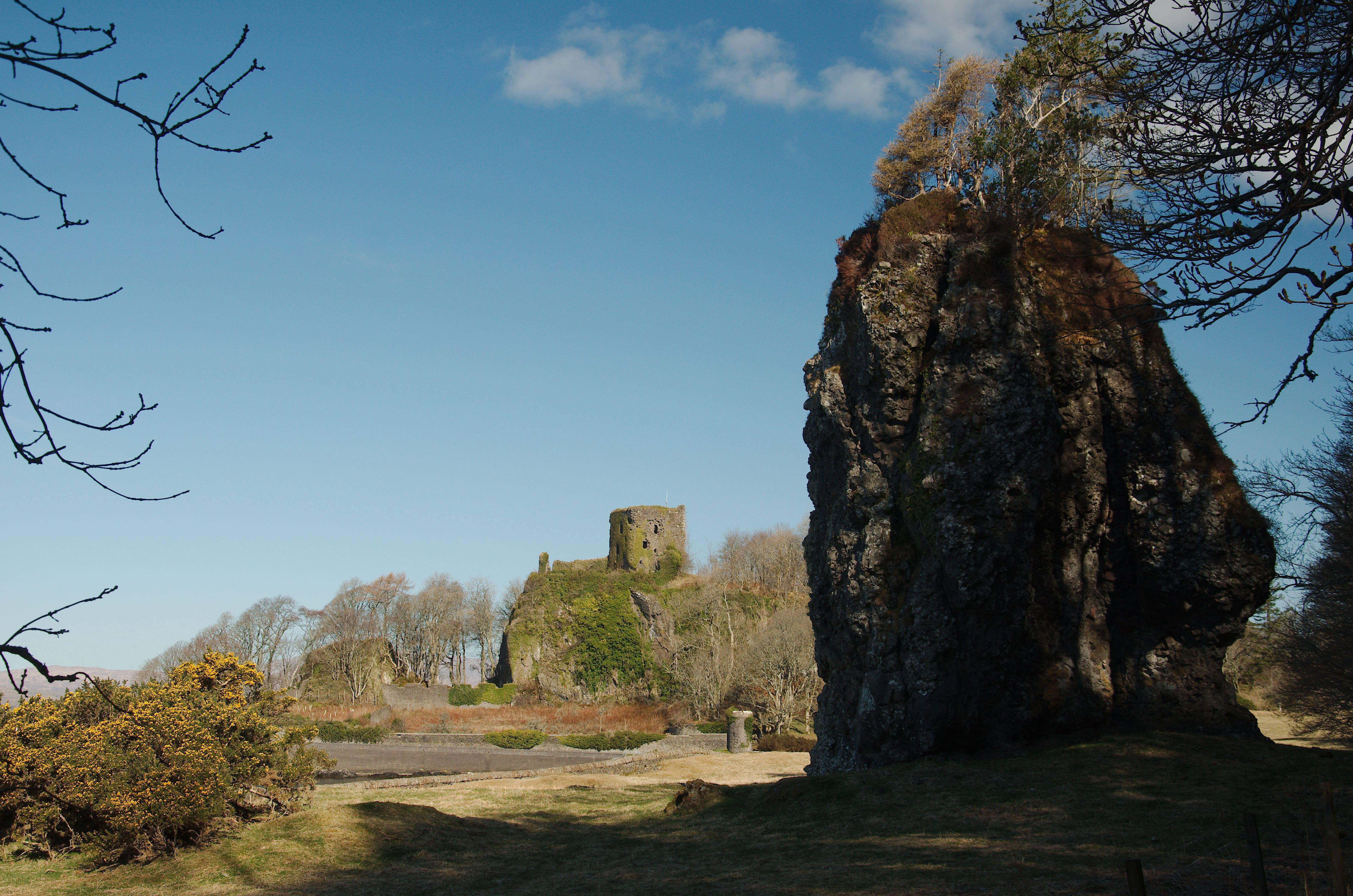
- Dunollie Castle is a ruined tower on a rock at the north end of Oban Bay, the old royal stronghold of the Cenél Loairn in Dál Riata.
- Selbach mac Ferchair destroyed Dun Ollaigh in 701 and rebuilt it in 714, and excavation later found a bronze-worker's hearth under a stone rampart.
- The MacDougalls, descended from Somerled, held the place, lost it after the Battle of the Pass of Brander, and recovered Lorn under David II.
- The standing tower is mainly of the fifteenth century, and the family left it in 1746 for a house on the slope below.
- The ruins are cared for with a museum and grounds, and the Brooch of Lorn is kept among the family collections.
Visiting
The site is closed for the season and will reopen in early spring, and tickets are required whenever the grounds are open. Opening hours in the season are Tuesday to Sunday from 10.00 to 16.00, and the site is closed on Mondays. From 17 March until the end of October 2026 the season was Tuesday to Sunday, 10.00 to 16.00, with last entry at 15.30. Another notice gives last entry at 15.15, so that visitors still have time before the site closes at 16.00.
Adult tickets are £13, concession tickets are £11, a child ticket for ages 5 to 15 is £6, and entry is free under 5. A family ticket for two adults and two children is £30, and a family ticket for two adults and three children is £34. One ticket becomes a pass for every later visit in that open season. Concession tickets are for people aged 65 and over, full-time students, people with a disability, and people receiving income benefits, and proof may be asked at the gate.
Groups of 10 or more may buy tickets at a reduction of 10 percent. Dogs are allowed to enter the outdoor areas, including the castle, only on a lead, and dogs are not allowed inside the 1745 House or the Draper's Shop. A further ticket of £4 is charged for the guided tour at 11.30 on Tuesday to Friday, the tour lasts about an hour and is mostly outdoors, and visitors should dress for the weather. The castle path is steep and uneven, wheelchairs and buggies are not allowed on it, and walking sticks may be borrowed where tickets are sold.
History
Dunollie Castle is a ruined tower and courtyard on a steep rock at the north end of Oban Bay, looking over Kerrera and the harbour. In Scottish Gaelic it is Caisteal Dhùn Ollaigh, and the older name Dun Ollaigh marks it as a royal centre of the Cenél Loairn in the kingdom of Dál Riata. Worked flints show use of the rock before the fort of the annals, and one account of the place allows a human presence measured in thousands of years.
The annals compiled at Iona name the fort in 686, 698, 701, 714 and 734. Selbach mac Ferchair destroyed it in 701 and rebuilt it in 714, in the years when he contended for the kingship of Dál Riata with his brother Ainbcellach and with the Cenél nGabráin. A capture near the citadel in 734, and the campaigns of Óengus son of Fergus two years later, brought Pictish power over this coast, while radiocarbon dates carry occupation of the early rampart from the seventh century into the tenth.
Small excavations in 1978 found a bronze-worker's hearth, moulds for stick pins, weapons, a gold wire ring, imported pottery and a collapsed stone rampart about five metres wide on the north. A later bank, perhaps of the thirteenth century, was built on the ruined line, and a worn silver penny minted between 1205 and 1210 points to wealth on the stack in that century. Cattle dominated the early food remains, and only a small fraction of the summit was opened.
The coast then lay in the Kingdom of the Isles. Somerled, who died at Renfrew in 1164, was the ancestor of the MacDougalls, and the Davidian Revolution in David I's reign formed the wider change in the Scottish kingdom with which he dealt. His grandson Donnchadh founded the lordship of Lorn, and Ewan MacDougall, after a Norwegian title and a Scottish expedition in 1249, stayed loyal to Scotland when Hákon's fleet lay off Oban in 1263.
In the Wars of Scottish Independence the MacDougalls stood with the House of Balliol and Clan Cumming. John of Argyll defeated Robert the Bruce at the Battle of Dalrigh in 1306, and Bruce broke the clan at the Battle of the Pass of Brander, most likely in the late summer of 1308. The lands were forfeited to the Campbells, Dunstaffnage was taken, and John died in England on a pilgrimage to Canterbury, in 1316 or in September 1317.
John Gallda recovered Lorn under David II, and the tower that stands today is largely of the fifteenth century, four storeys and roughly twelve metres square, with a courtyard about twenty-four metres across. The Marquess of Argyll's forces took the castle in 1644, and David Leslie's army sacked and burned it in 1647. The family left the tower in 1746 for the house on the slope below.
A trust now cares for the buildings and the collections, including the Brooch of Lorn, whose famous seizure at Dalrigh is clan tradition while the surviving metal is centuries later than Bruce. In 2016 volunteers reopened part of an old trench in the courtyard before repair of the fabric. The chief is still a MacDougall of Dunollie.
Images




Detailed History
Dunollie Castle stands on a steep stack at the north end of Oban Bay, in the parish of Kilmore and Kilbride, in Argyll and Bute. In Scottish Gaelic the ruin is Caisteal Dhùn Ollaigh. The rock looks over the Sound of Kerrera, the island of Kerrera, the town and its harbour, and the isles beyond. The standing masonry is a small tower and courtyard of the later Middle Ages.
Under and around that stone is an older fortified place, the Dun Ollaigh of the early annals, a royal centre of the Cenél Loairn inside the kingdom of Dál Riata.
The stack is basalt-capped sandstone, falling almost sheer on the south, west and east, with a stepped spur to the north that drops toward the shore. The tower and courtyard occupy only part of the summit. On the north and east, banks remain that have no structural bond with the later masonry. A visitor account of the ruins says they have watched the bay for more than seven hundred years, and that the same ground was lived on for far longer.
That account says archaeology suggests people were here for around eight thousand years. The 1978 cuttings found worked flints of Neolithic or Bronze Age character, so some use of the rock is older than the fort of the annals, without fixing a single date for the first fire on the summit.
Scottish Gaelic is the language of the castle’s own name and of several names in its later story. It is a Goidelic language, beside Irish and Manx, grown out of Old Irish. It became a distinct spoken language sometime in the thirteenth century, in the Middle Irish period, while a common literary language was still shared by the Gaels of Ireland and Scotland well into the seventeenth century. The usual account is that Gaelic came to the west coast in the fourth and fifth centuries with settlers from Ireland who founded Dál Riata.
An alternative, argued from archaeology and place-names, is that Argyll was already part of one Q-Celtic-speaking world with Ireland, joined by the sea rather than divided by it, and that a migration or takeover is not required by the material evidence. Both readings leave the rock’s later names in Gaelic. Dail Righ, the field where a MacDougall army met Robert the Bruce, is “the King’s Field” in Scottish Gaelic. The word dun itself remained a living word for a fort, or for a rocky hill that might carry one.
Dál Riata was a Gaelic kingdom on both sides of the North Channel, the western seaboard of what is now Argyll and part of north-eastern Ireland. At its height in the sixth and seventh centuries it covered the coast of the Gaels. In Scotland it was organised in kindreds. The Cenél nGabráin was centred in Kintyre, the Cenél nÓengusa on Islay, the Cenél Comgaill, which split from the Cenél nGabráin around 700, in Cowal and Bute, and the Cenél Loairn in the north, the district that still carries the name Lorn.
Royal forts included Dunollie, Dunadd, Dunaverty and Dunseverick. Iona, inside the same sea-world, was a monastery of learning and of the spread of Christianity through northern Britain. The kingdom is said to have been founded by Fergus Mór in the fifth century. It reached a high point under Áedán mac Gabráin, whose reign is given as 574 to 608, with expeditions toward Orkney, Man, Strathclyde and Bernicia, until Æthelfrith of Bernicia checked that growth at Degsastan in 603.
Serious defeats under Domnall Brecc, who died in 642, ended that earlier strength, and for a time the kingdom was a client of Northumbria. The name Dál Riata is Old Irish, “the portion of Riata”. Bede said the kingdom was named for a founder called Reuda. Other texts tie the name to the Corcu Réti or to Cairbre Riata.
The Cenél Loairn were the descendants of Loarn mac Eirc. Their ground was northern Argyll around the Firth of Lorn, and they likely also held Mull, Tiree, Coll and Colonsay, with Morvern, Ardnamurchan and parts of Lochaber. The Druim Alban ridge was the eastern boundary with Pictland. Their chief places appear to have been Dun Ollaigh near Oban and Dunadd near Crinan.
Dunadd lay at the southern edge of their reach and was a place of the high kings. There is no direct evidence that Dun Ollaigh was subordinate to Dunadd. The seventh-century Senchus fer n-Alban, the oldest known census in Britain, counts houses as the unit of military and naval service. For every twenty houses a kindred owed the crew of two seven-bench ships.
The Cenél Loairn were assessed at 420 houses and a muster of 600, inside a Dál Riatan force of about two thousand. A later reading of the same survey has inferred an earlier Lorn assessment of no more than 225 houses. The kindred’s first king in the surviving record to be claimed for this descent was Ferchar Fota, who died about 697.
The annals compiled at Iona name Dun Ollaigh five times, in 686, 698, 701, 714 and 734. That is the largest number of mentions for any one fortified site in those annals, a figure as likely to reflect how near the rock stood to Iona as to measure its rank. Four entries call it a dun, a fort, and the fifth uses the Latin arx, a citadel, so its fortified character is plain. In 686 and 698 it was attacked or burned.
In 698 the same annal also records the expulsion of Ainbcellach son of Ferchar from the kingship, and that he was bound and taken to Ireland. Those two items sit next to each other among six items for the year. They need not be cause and effect, though a successful challenge to the overlordship of the Cenél Loairn is a fair reading. In 701 Selbach mac Ferchair destroyed Dun Ollaigh.
In 714 he built it, which is to say he rebuilt it. In 734 a Pictish leader, Talorgan son of Drostan, was captured and bound near the citadel of Ollaigh.
Selbach mac Ferchair, who died in 730, was king of the Cenél Loairn and of Dál Riata, a son of Ferchar Fota, and a man the annals mention again and again. He ruled the Cenél Loairn from about 698 until he abdicated in 723, and he may have been undisputed king of the whole kingdom only in his last years. He had two sons, Dúngal and Feredach. His father, brother, son and nephew appear among the predecessors of Malcolm III in the Duan Albanach, but Selbach himself does not, which may be a form of deliberate forgetting.
He likely deposed his brother Ainbcellach in 698. Why he destroyed Dun Ollaigh in 701 is not known: the enemy may have been Ainbcellach, a king of the rival Cenél nGabráin, or someone else. Battles of Dál Riata in his time include a defeat in Glen Lemnae in 704 and victories over the Britons at Lorg Ecclet in 711 and at the rock called Minuirc in 717, though the annals do not name Selbach in those reports. In 712 he besieged Aberte, identified with Dunaverty in Kintyre, in the lands of the Cenél nGabráin.
In September 719 he fought Ainbcellach at Finnglen, perhaps near Loch Fyne, and Ainbcellach was killed. A month later he met Dúnchad Bec, king of the Cenél nGabráin and of Kintyre, in a sea battle off Ard Nesbi. Selbach was defeated. Dúnchad Bec died in 721, which may have left Selbach unchallenged.
In 723 he abdicated into a monastery, and one annalist then calls him lord of Dál Riata. His son Dúngal probably succeeded him and was replaced by Eochaid mac Echdach in 726. In 727 Selbach was fighting Eochaid’s supporters at Irros Foichnae.
The destruction of 701 and the building of 714 leave a gap. If the destruction was only the burning of timber, a stone dun on the crown could have survived. The annals are too short to show either the damage or the intention. What they do show is that Dunollie mattered in the contest for the kingship.
In or after 700, supremacy may have passed from the Cenél nGabráin to the kindred of Lorn, who may have pushed south to Dunadd and parts of mid-Argyll. In that Irish pattern of society, a kindred was a tuath with its own rí, and the struggle between Lorn and Gabráin was a struggle for the overkingship. In 736 Óengus son of Fergus ravaged Dál Riata, seized Dunadd and burned Creich, and had two sons of Selbach chained as hostages. His domination may have lasted until his death in 761.
Nothing distinctively Pictish is known among the finds from Dunollie, but the rock is reasonably included in the area he dominated. From 795 there were Viking raids through the islands of this coast: on the islands of Britain in 794, on Skye and Iona in 795, on the Hebrides in 798, and on Iona again in 802, 806 and 825. Norse settlement is clear in the isles and in names of farms, and on Islay the farm-names are many. On the mainland heart of Lorn and mid-Argyll the evidence of graves and of settlement-names is thin.
Dunollie and Dunadd were still occupied through those decades, and it is a reasonable suggestion that they helped keep Norse settlers out of that heartland.
There is disagreement about the kingdom after the middle of the eighth century. Some scholars see no revival of Dál Riatan power after a long foreign domination from about 637 to about 750 or 760. Others see a revival under Áed Find, whose dates are given as 736 to 778, and some argue that the Dál Riata took the kingship of Fortriu. Sources differ on whether Cináed mac Ailpín, Kenneth MacAlpin, was king of Dál Riata before he became king of the Picts in 843, after a heavy Pictish defeat by Vikings.
The kingdom’s independence ended as it merged with Pictland into the Kingdom of Alba. Later influence of the Cenél Loairn, probably as the isles passed into the Norse-Gaelic Kingdom of the Isles, seems to have shifted toward Moray, whose rulers still claimed descent from the kindred as late as the twelfth century. The chief religious place of the Cenél Loairn may have been Lismore, likely absorbed into that island kingdom once Viking power arrived in the late eighth century.
In 1978 Leslie Alcock and Elizabeth A. Alcock cut two small trenches into the earthworks, one on the north of the stack and one on the east, looking for the Dun Ollaigh of the annals. Five or more phases appeared. Phases one to three date to the seventh to ninth centuries, or even the tenth.
They include a wall-faced rubble rampart around the summit. After a period of dereliction, a later rampart, perhaps of the thirteenth century, was built on the ruined line. Only about two percent of the summit was opened, and no external middens were found, so the picture is true of the cuttings and cannot be assumed for every unexcavated yard.
Before any rampart was built on the northern edge, a bronze-worker’s hearth stood there, with spreads of burning. Clay moulds show that the main product on that spot was the simple stick pin, sometimes several pins in one mould, and in one case a globular pinhead. Another mould was for a nail-headed pin and a finger-ring. A further mould has a curved groove that may have been for the hoop of a penannular brooch.
An iron spearhead with a heavy midrib, socketed iron arrowtips, bone and antler pins, and a double-sided composite antler comb with dot-and-circle ornament belong with this early use. Three radiocarbon estimates from animal bone and oak charcoal in the burning, calibrated at ninety-five percent, fall at 600 to 890, 610 to 880, and 470 to 650. The older oak date can be explained if the tree was already a century or more old when it was felled. The general implication is a seventh- to ninth-century phase, and the hearth, the weapons and a sherd of imported pottery of continental Class E make this the seat of someone of rank, royal or noble.
There is no artificial defence on the northern perimeter in this first phase, and the eastern cutting is best read the same way. A small thick-walled drystone dun on the crown, of the sort later called a dun in the technical sense, remains a hypothesis. Such a building could have been wiped out when the tower house was raised.
That hearth was immediately overlain by a rubble bank, revetted in front with massive slabs and kerbed at the rear. On the east a comparable bank sits on the bedrock at the lip of a cliff about ten metres high, and there the rampart was only about two metres wide. On the north, where the slope is less absolute, it was about five metres wide, with the hillside quarried into a scarp a little over a metre high and a shallow ditch in front. There is no direct date for this rampart.
It sits between the seventh- to ninth-century estimates from below and dates from the overlying rubbish of the later ninth to eleventh centuries. It is tempting to tie the building to the annal for 714, when Selbach built Dun Ollaigh, but the dates are not tight enough to make that certain.
The next phase is abandonment. The rampart collapsed, its profile lowered, and it grassed over. Before that, rubbish that had gathered behind it spilled over the failing stone. The rubbish carries the same kinds of objects as the first phase, so the three early phases are one cultural period.
Two further radiocarbon estimates on cattle, pig and sheep bone from that spill calibrate to 875 to 1055 and 865 to 1045. Together with the earlier results they put the early occupation from the seventh century into the tenth. A public summary of the site says the early fortification was abandoned sometime in the tenth century. The radiocarbon range and the knives with angled backs, which suit the ninth or tenth century rather than an earlier one, allow occupation to have lasted into that century.
Both statements can stand: the early fort was out of use by or during the tenth century, and the samples do not draw a sharper line.
Centuries later a second bank was laid on the grass-grown ruin. Its core was small, chippy rubble, loosely packed, about two metres wide on the east and about three on the north. A front revetment is preserved in courses of large blocks on the east and can be inferred on the north from slabs that had fallen down the slope. A rear cheek of stacked turves is clear on the north.
The silt against the older scarp was cut back, the ditch cleaned, and the spoil piled into a low counterscarp bank. Surface traces suggest this line ran round the north-western corner and along the western cliffs, where the courtyard wall of the masonry castle later cut it. A silver penny of John of England, minted between 1205 and 1210 and only a little worn when lost, came from the core of this bank, in ground badly disturbed by tree roots. The same layer also produced pieces of a seventh- or eighth-century pottery beaker and a copper coin minted between 1632 and 1639, so the penny is not a clean stratigraphic date.
Even so it points to activity and some wealth on the stack in the early thirteenth century, and an unstratified potsherd may take a phase of use back into the twelfth. An earthwork castle in the far west at that date is reasonable. Material against the rear of the later rampart, from the time of the tower and after, included coins of 1629 to 1639 and a jetton of about 1580 to 1610.
The animal bone from the early layers, 307 stratified fragments studied without wet-sieving, is almost all unimproved domestic stock, butchered on the site and heavily split for marrow. Of identifiable fragments, cattle were about 64 percent, pig about 19 percent, and sheep or goat about 17 percent. Fish, probably marine, appeared as three bones, and horse as two. Red deer appeared only as antler, which may mean the antler was shed rather than cut from a hunted carcass.
There were no bones of other game, of fowl, or of dog or cat in the sample, absences that may only reflect how small the sample is. Ages at death do not show a clear pattern of killing young male cattle for meat while keeping cows for milk, though that Irish pattern is not ruled out: the cattle range from a mature animal of four or five years, through a young adult and juveniles, to a calf or late embryo that may have been killed for vellum or fine leather. Most sheep or goats were killed at under eighteen months, which looks like meat rather than wool. Some pigs were adult but under three years.
Beef, by count and by carcass weight, was the main meat, with lamb, mutton and pork as occasional meals, and an unmeasured share of milk, butter and cheese. Cattle were also a mark of status and a means of clientship in contemporary Ireland, and there is no reason to think those uses were dropped when the Gaels held this coast. Charcoal from the hearth layer was about two-thirds oak, which fits the feeding of pigs on acorns, though that is only a suggestion. No actual grain of oats or barley was recovered, and four querns of a western type known from the first century onward were all unstratified, so milling is not proven.
Pockets of arable on this coast, worked with horse, ox or foot-plough up to about two hundred metres above the sea, are likely on general grounds, but they are not evidenced in these cuttings. Modern land classification, built for mechanised farming, marks very little of Lorn as good arable and would cast the economy as stock-raising alone. Abandoned rigs from before the later eighteenth- and nineteenth-century clearances show that such maps understate what a small plough could use.
Iron from the early phases includes the spearhead, one small socketed arrowhead, and four socketed points about ten millimetres across, read as arrowtips rather than as ferrules for spear butts. They would have added penetrating power. Spear and arrows could have been for the hunt as much as for war. A T-shaped woodman’s axe, a chisel, an awl and a very small hammerhead, perhaps a bronzesmith’s rather than a carpenter’s, were well stratified.
Iron nails appear only after the later rampart. There is no evidence in the northern cutting for smelting iron, and the hearth with crucibles, a tuyère and moulds is far more likely bronze-working than a forge. No bronze slag was found, so the metal is inferred from the moulds. An elongated hollow in a sandstone slab was probably for casting silver ingots.
The only precious metal actually present was a crude ring and two links of chain in gold wire, likely deposited before the later rampart. A minute sherd of probably Teutonic glass, of the kind imported as cullet for beads and enamel, came from a later level. A small annular bead of opaque cobalt-blue glass fits the later first millennium. A rim from a glass bowl of Roman make, painted with arena scenes and manufactured in the third century, cannot date the first occupation.
Such bowls travelled beyond the imperial frontier as prized goods. This one had probably reached northern Ireland with Roman silver in the later third or fourth century, survived as an heirloom, and come to Scottish Dál Riata with an immigrant family. It was found high in the ditch fill.
Domestic pottery is almost absent from the early layers, which matches the scarcity of coarse pottery on contemporary sites in mainland Argyll and in the Irish homeland. Wooden vessels would have filled the gap, as they did at the crannog in Loch Glashan, where bowls, a bucket, a trough, a scoop and a spoon survived in water. Leather was available from the cattle, but leather vessels are scarcely recorded on contemporary waterlogged sites; shoes are the common leather product. A bronze clamp for the rim of a wooden or leather cup is one hint of those vessels.
On a modest scale, high-status households of the seventh and eighth centuries imported post-Roman Class E pottery, a hard, gritted kitchen and table ware for jars, beakers, bowls, jugs and lids, probably from western or northern Gaul. Fragments of four vessels came from the small area opened in 1978, including a beaker from the dereliction phase. Dunadd, much more fully excavated, produced a minimum of twenty-five, and Loch Glashan at least five. The routes are not well understood.
An Irish Sea distribution suggests a port no farther north than the mouth of the Loire, and one reading is that the pots were incidental to wine in cask from the Bordeaux region, or that beakers held dyes, spices or unguents. Class D fine grey ware, a stronger pointer to the Bordeaux trade, is known at Dunadd and not yet at Dunollie. Adomnán, writing in the later seventh century, tells of Gaulish sailors met by Columba at a caput regionis, a chief place of the region, which he does not name. There is no proof that either Dunadd or Dunollie was a fortified political centre in Columba’s lifetime in the later sixth century.
By Adomnán’s day, Dunollie, with the better harbour, is the more likely port of the two, but that is not an identification.
Exports that could have paid for wine, pottery, cullet and dyes would have been natural products: hides, perhaps slaves, and portable luxuries such as white furs, crystal and other stones. The surplus also supported fort-building, a war-band and resident craft. Compared with Dunadd, the usable area inside the early rampart at Dunollie was about 1,850 square metres against about 2,500 at Dunadd, roughly three-quarters. That is not a gap of rank.
Dunadd’s nuclear plan and its inauguration carvings, the footprint and the bowl, show a special role that Dunollie has not revealed, and much of Dunollie’s interior was surely destroyed when the tower and courtyard were built. In an earlier phase both places may have been simple summit duns, one for the Cenél nGabráin and one for the Cenél Loairn. Lesser duns of Argyll, many of them occupied in the centuries either side of the year 700, read as the strongholds of households below that royal tier. A technical upper size near 375 square metres has been used to separate a family dun from a communal fort, but the measured duns run from about 20 square metres to above that line, and almost a third have outworks.
The Senchus counts far more houses in Lorn than there are surviving duns, so the dun cannot simply be equated with every free household. Between king and free farmer stood nobles, the comites of the 719 sea battle, and the kindred of Lorn had about nine septs. Dunollie in its rampart phase was a place for an overking, not a farm.
The area around the rock later lay in the Kingdom of the Isles. Somerled, who died in 1164, was a Norse-Gaelic lord, Somairle in Middle Irish and Sumarliði in Old Norse. Little is certain of his birth. He may have been born in the north of Ireland, and his father GilleBride appears to have made a marriage alliance with Máel Coluim mac Alaxandair, a son of Alexander I of Scotland and a claimant to the throne.
During a period of alliance with David I of Scotland, Somerled married Ragnhild, daughter of Óláfr Guðrøðarson, King of Man and the Isles, in 1140. The Davidian Revolution is the name many scholars give to the changes in the Kingdom of Scotland during David I’s reign, from 1124 to 1153: the foundation of burghs, the ideals of Gregorian reform, new monasteries, a government staffed in Norman fashion, and feudal tenure granted to incoming Norman, Anglo-Norman and Flemish knights. Those changes remade the institutions of the kingdom to the east and south. They do not, by themselves, build the rampart on this stack.
They are the setting in which Somerled dealt with David’s kingdom, and in which, a century later, lordship in the west was pulled toward the Scottish crown. In 1153 Óláfr of Man died and his son Guðrøðr succeeded him. Guðrøðr was unpopular. In 1156 Somerled, asked to put forward his son Dubgall as king, met Guðrøðr off Islay with eighty ships on 5 and 6 January.
The kingdom was divided. Two years later Somerled defeated Guðrøðr again and held Argyll, Man and the Isles until his death. He was killed at the Battle of Renfrew in 1164, invading the mainland with forces drawn from across his kingdom. The reasons are unknown.
The scale suggests ambition beyond a mere check on Scottish pressure. In his last year he tried to persuade Flaithbertach Ua Brolcháin, Abbot of Derry, to move the headship of the Columban community from Ireland to Iona. His death ended that plan. His sons kept much of the southern Hebrides, and the great kingdom broke up.
Dubgall mac Somairle, who died in 1175, was a son of Somerled and Ragnhild, and the eponym of Clann Dubgaill, the MacDougalls. In 1155 or 1156 he was put forward for the kingship of the Isles. His father held the real power. At least one of Somerled’s sons was killed at Renfrew; it is not known whether Dubgall was there.
In 1175 Dubgall is recorded giving to St Cuthbert at Durham. He, his father, or his brother Ragnall may have founded the Diocese of Argyll. He may have held Lorn and the Mull group of islands. His descendants were the strongest branch of Somerled’s kindred until the fourteenth century.
The clan takes its name from him. Dougall, or Dugald, is from Gaelic dubh-gall, “dark foreigner”. He was styled King of the South Isles and Lord of Lorne, and that royal descent was acknowledged by the king of Norway. After Somerled’s death he held most of Argyll and the islands of Mull, Lismore, Jura, Tiree, Coll and others.
Donnchadh of Argyll, Duncan son of Dougall, was the first of these lords to use the style de Argadia, “of Argyll”, and he can be regarded as the founder of the successful MacDougall lordship. He appears in 1175 with his father and his brother Amhlaibh in the Durham Liber Vitae, on a pilgrimage to St Cuthbert. Alexander II led expeditions into Argyll in 1221 and 1222 which left Donnchadh recognised or appointed to the lordship of Lorn. Around 1225 he appears as Donnchadh de Argadia in a charter of Maol Domhnaich, Earl of Lennox, to Paisley Abbey, the first attestation of that locative name.
He remained with the Scottish crown against Ruaidhrí mac Raghnaill. In 1230 a Norwegian expedition led by Óspakr-Hákon, probably his brother, ravaged Kintyre and attacked Bute, and Óspakr-Hákon died. Donnchadh kept Argyll. He built Ardchattan Priory, where the chiefs were buried until 1737, and he is credited with Dunstaffnage Castle.
His death is not fixed. He may be the “Mac Somhairle” who died at Ballyshannon in 1247. A later list gives his death somewhere between 1237 and 1248. The earthwork castle on the Dunollie stack, the rampart of small rubble, may belong to the late twelfth century or the thirteenth, and its builder may have been Dougall, who died in 1207, or his son Duncan.
Dunstaffnage, on architectural grounds, is placed in about the second quarter of the thirteenth century, and it may have replaced that earthwork as the principal castle. One clan account says Duncan and his son built Dunollie, Dunstaffnage and Duntrune on the mainland, and Aros, Cairnburgh, Dunchonnel and Coeffin on the islands. Another account places a castle at Dunstaffnage already in Somerled’s time, with the seat becoming Duncan’s in the second quarter of the thirteenth century.
Ewan MacDougall, Eóghan son of Donnchadh, grandson of Dubgall and great-grandson of Somerled, was the third chief. He was styled King of the Isles and Lord of Argyll. After the death of Haraldr Óláfsson, King of Man and the Isles, in 1248, Hákon Hákonarson, King of Norway, appointed Eóghan king of the Isles, in the Scandinavian account. Within a year the title went to his paternal second cousin Dubgall mac Ruaidhrí.
In 1249 Alexander II of Scotland launched an expedition against him after he refused to renounce homage to Hákon. Alexander fell ill and died on that campaign. Eóghan seems to have been temporarily deprived of his Argyll lands. In 1250 he tried to take the Isle of Man and was expelled by the inhabitants.
He went to Norway seeking recognition as king of the Isles and failed. By 1255 Henry III of England had secured a deal by which Eóghan regained Lorn and came into full Scottish allegiance. His island possessions were held from Norway and his mainland possessions from Scotland, which made a single loyalty difficult. In 1263 Hákon came with a large fleet off Oban to invade the west coast.
Ewan MacDougall refused him service. Old blood ties, in the clan account, led Hákon to leave him in peace. Eóghan stayed a Scottish loyalist, and after Hákon’s defeat at the Battle of Largs he attacked part of the Norse fleet. Hákon died later that year.
The Treaty of Perth, three years later, ceded the Hebrides to Scotland, while Scotland recognised Norwegian sovereignty over Shetland and Orkney. Eóghan’s last recorded appearance is in 1268. A later list places his death between 1268 and 1275. His son Alasdair, Alexander of Argyll, followed him as lord.
His daughter Maria, who died in 1302, married four times: Magnús Óláfsson, King of Man and the Isles; Maol Íosa II, Earl of Strathearn; Hugh, Lord of Abernethy; and Sir William FitzWarin.
Alexander of Argyll married a daughter of John Comyn I, Lord of Badenoch. In February 1293, while John Balliol was king, Alexander was appointed sheriff of Lorn. The House of Balliol and the kindred of Clan Cumming, the Comyns, were the alignment he and his son kept. Alexander extended his power against the MacDonalds of Islay and defeated the Campbells of Loch Awe in the mid-1290s.
The Wars of Scottish Independence, from 1296, placed the MacDougalls on Balliol’s side. In 1294, or sometime after September 1296, John of Argyll’s forces killed Cailean Mór, Colin Campbell, at the Red Ford on the border of Loch Awe and Lorn. The sources do not agree on the exact year, and the cause of the fight is not clear. Colin was bailie of Loch Awe and Ardscotnish, granted the office either by John Balliol or by Edward I.
In 1299 Alexander killed Alexander Og MacDonald, Lord of the Isles, in Ireland. John of Argyll had sworn fealty to Edward I in 1291. By 1305 he and his father sat on the advisory council of Edward’s lieutenant in Scotland, John of Brittany. One account says there is no contemporary authority for the nickname Bacach, “the lame”, by which later tradition knows John.
Other accounts use that name freely.
On 10 February 1306 Robert the Bruce and his men killed John Comyn III, the Red Comyn, in Greyfriars church in Dumfries. Bruce was crowned at Scone. The Comyn kin, and the MacDougalls who were bound to them by marriage, treated Bruce as the greater enemy and fought on the English side of the war. On 19 June 1306 Aymer de Valence caught Bruce’s camp at Methven, west of Perth.
What remained of the army went west. Between July and early August, at the hamlet of Dalrigh near Tyndrum, John of Argyll blocked the path. The Battle of Dalrigh, also called Dail Righ, Dalry and Strathfillan, was fought in Perthshire near the Argyll border, not at Dalry in Ayrshire. A later account gives the MacDougalls as about a thousand and Bruce’s company as three hundred to five hundred, including women, the old, and a guard of Highland men.
The only narratives are pro-Bruce. John Barbour has the king waiting boldly with too few followers. The lack of any description of preparation allows the other reading, that the MacDougalls took a beaten army by surprise. MacDougall axemen killed the remaining horses and wounded many, including James Douglas and Gilbert de la Hay.
Bruce disengaged, kept the company together, and rescued the rear. He escaped capture. Locals have placed the field at several names nearby, among them Lasantulich, Dalchaisnie and Inverchaddan. It is uncertain whether Dail Righ was the name at the time or a name added later.
The Brooch of Lorn, Braìste Lathurna, is a turreted disc brooch traditionally taken from Bruce at that field and kept at Dunollie as a chief treasure. The silver disc is about four and a half inches across, with a later hinged pin, and a large quartz charm-stone set above an empty compartment that was said in 1905 to hold fragments of bone. Eight detached turrets, about an inch and a quarter high, each topped with a Scottish freshwater pearl, stand around the stone, with filigree stars and cabled borders. Specialists agree it is later than Bruce’s lifetime.
One museum description dates it on style to the late sixteenth century, resetting an older crystal. Another curator has put the brooch in the mid-fifteenth century and suggested that an original brooch may have been lost and the famous stone reset. It is one of three West Highland turreted brooches of that broad age, with the Lochbuie brooch and the Ugadale or Lossit brooch. It is owned by the trust that cares for Dunollie, was rarely shown, and was loaned to an exhibition in London in 2012.
The tradition and the date of the metal cannot both be literal. The crystal may be older than the setting. The story of a brooch seized at Dalrigh is the clan’s tradition, not a description of this surviving object in 1306.
Bruce recovered, began a war in Ayrshire in the spring of 1307, and was helped by the death of Edward I in July 1307 near the Scottish border. Edward II turned to English politics. In September 1307 Bruce attacked Galloway. He then went north with a fleet of galleys up Loch Linnhe.
John, acting for his elderly father and writing to Edward that he was recovering from illness, asked for a truce. Bruce turned on John Comyn, Earl of Buchan, through the winter, and broke him at Inverurie in May 1308. The Battle of the Pass of Brander followed. The sources do not fix the date.
Years from 1308 to 1309 have been suggested. The late summer of 1308 is the most likely, and one historian dates it to August 1308. A clan account of Dunstaffnage says Bruce besieged that castle after a defeat in 1309, which is the other end of the same range. John placed men in the narrow Pass of Brander, where the River Awe cuts the southern slope of Ben Cruachan below Loch Awe.
Only Barbour’s poem places the fight, without naming the pass, though the description fits, and cairns around the Bridge of Awe have been taken as support. John watched from a galley on Loch Awe. His men were hidden on the hillside. Bruce, who now had the men and the experience, sent archers under James Douglas higher up Ben Cruachan into the enemy’s rear.
When the MacDougalls attacked they were caught between the king below and Douglas above. They broke, and were chased west across the River Awe toward Dunstaffnage. John escaped down the loch and eventually reached England, as the Earl of Buchan did. Alexander, the Lord of Argyll, surrendered and did homage, then the next year joined his son in exile.
He died in 1310 in the service of Edward II. One list allows 1310 or 1311, perhaps at Carlisle.
A later argument moves the fight north to the shore of Loch Etive and would rename it the Battle of Ben Cruachan. That reading is hard to square with a march from the east, which would still have to clear the pass, and with the danger of advancing along Loch Etive in sight of enemy galleys. A galley is also a way off an inland loch. The traditional pass remains the better reading of the poem, and the doubt about the exact ground is real.
Dunstaffnage, the main MacDougall seat, was taken by Bruce’s forces. John fled to England. His father joined him by 1310, and both attended a council at Westminster. John commanded English fleets in 1311 and 1314 as Admiral of the Irish Sea, and in 1315 he took the Isle of Man for the English crown.
From 1316 he had a pension from Edward II. He died at Ospringe in Kent on a pilgrimage to Canterbury. One account places the death in 1316, another in September 1317. He left sons Ewen, Alan, Somhairle and Alexander Og, and a daughter Mary, and another daughter who married Patrick de Graham.
His Galwegian ally Dungal MacDouall was left in charge of his will. The MacDougall lands of Lorn were forfeited and given to the Campbells. Bruce made Dunstaffnage a royal castle with Campbell keepers. The power the clan had held in the thirteenth century, when its chiefs were the original lords of Argyll and then of Lorn, did not return in the same form.
Clan Donald, who had backed Bruce, rose in the isles, and Clan Campbell rose on the mainland.
John’s grandson John Gallda MacDougall, “the foreigner”, Lord of Lorn, is on record from 1338. In the mid-fourteenth century he came back from England, married a niece of David II, and regained the ancestral lands in Lorn. Most of the mainland lands were returned by a royal charter of David II. After John Gallda’s death the lordship of Lorn passed to the Stewarts.
The chiefly line continued through his son Allan. In 1468 the clan fought Clan Stewart of Appin at the Battle of Stalc. The standing ruins of Dunollie are largely of the fifteenth century. The tower is a classic Scottish tower house of four storeys, roughly twelve metres square, with walls between 2.7 and 3.4 metres thick at the base, a barrel-vaulted cellar, a great hall, and the remains of private rooms above.
A courtyard about twenty-four metres across stood beside it, closed by a curtain. The masonry is local igneous rubble in lime mortar, the same rock the stack is made of. Parts of the curtain are later than the fifteenth-century core, and one account places that later curtain work in the sixteenth century. The castle had become the seat of the chief.
In the Wars of the Three Kingdoms the MacDougalls were generally royalist. Chief Alexander MacDougall led five hundred clansmen. Archibald Campbell, 1st Marquess of Argyll, born in March 1607 and executed on 27 May 1661, was the leading Covenanter politician of those decades and the de facto head of Scotland’s government for much of the 1640s and 1650s. The castle was attacked in 1644 by Argyll, chief of Clan Campbell.
A shorter account says the Marquis of Argyll captured it in 1644 and that it was returned to the MacDougalls in 1661. In 1647 a Covenanter army under David Leslie besieged the castle, which was sacked and burned, and Gylen Castle on Kerrera was burned in the same campaign. After the defeat of James Graham, 1st Marquess of Montrose, Leslie was sent into Argyll against royalist supporters. The lands were restored after the monarchy returned in 1660, which sits beside the date of 1661 for the return of the castle.
In the Jacobite rising of 1715 the clan fought at Sheriffmuir. The chief was forced into exile, lived as a fugitive, and was pardoned in 1727. One account says the castle was attacked in that rising, the lands forfeited, and the lands restored in 1745. His son Alexander did not join the rising of 1745.
A brother and some of the clansmen fought at Culloden in 1746, and the clan’s fighting strength at that time is given as two hundred men. In 1746 the family left the tower for a more comfortable house on the slope below, the house now called the 1745 House. One account notes an earlier house on that ground from about 1600. The old castle was abandoned to weather and ivy.
The clan account calls the ruin dangerous, and it remains in MacDougall ownership. The present chief is Robin MacDougall, 32nd of MacDougall and Dunollie, son of Morag Morley MacDougall, who died in February 2026. She was the daughter of the sister of Coline Helen Elizabeth MacDougall of MacDougall and Dunollie, herself a daughter of Alexander James MacDougall of Dunollie. The chief represents the senior line of Somerled’s descendants.
The coat of arms used for the chief, dated in this form to 1931 and close to an eighteenth-century stone at the chiefs’ burial ground of Kilbride, quarters a silver lion on blue with a black galley, sails furled, on gold, under a red beacon.
In July 2016 a small part of a large trench in the northern half of the courtyard was reopened so that the sequence could be read again before consolidation and landscaping. The first dig on that ground had been in the 1970s. Four volunteers worked with Roderick Regan. Among what they found was mounded soil, possibly the weathered remains of an old spoil heap.
The wider project, running from March 2016 to July 2017, set out to record the tower’s fabric, to look at the earthworks, and to re-excavate a courtyard trench. A recent account of the place also says that remains of a historical herb garden have been found in the grounds. A charitable trust, the MacDougall of Dunollie Preservation Trust, cares for the buildings and the collections. It runs the museum, castle and grounds.
The 1745 House holds the family’s objects, including the Brooch of Lorn. The grounds include woodland, a garden called the World of Trees, a willow hall and a faerie garden.
Air Departure Tax is a pending Scottish levy meant to replace the existing passenger duty on flights. The statute was passed in 2017 and was first expected to apply from 1 April 2018. Introduction was delayed because of the exemption for flights from the Highlands and Islands, and the levy is now expected from 1 April 2027. A plan to cut the rate by half and later abolish it was dropped in 2019 as incompatible with climate targets.
That tax is a matter of airports. It is not a charge at this gate, and it has no part in the medieval or early modern history of the rock. The history that does belong here runs from a bronze-worker’s hearth and Selbach’s rebuilding, through Ewan MacDougall’s choice between two kings, to a fifteenth-century tower, a burned royalist house, and a family that moved downhill in 1746 and is still the chief’s family.
Sources
- Dunollie Castle — Wikipedia
- Ewan MacDougall — Wikipedia
- Battle of Dalrigh — Wikipedia
- Battle of the Pass of Brander — Wikipedia
- Cenél Loairn — Wikipedia
- Dál Riata — Wikipedia
- Davidian Revolution — Wikipedia
- Scottish Gaelic — Wikipedia
- Selbach mac Ferchair — Wikipedia
- Somerled — Wikipedia
- Dubgall mac Somairle — Wikipedia
- Donnchadh of Argyll — Wikipedia
- John of Argyll — Wikipedia
- Clan MacDougall — Wikipedia
- Brooch of Lorn — Wikipedia
- Archibald Campbell, 1st Marquess of Argyll — Wikipedia
- Air Departure Tax — Wikipedia
- Reconnaissance excavations on early historic fortifications and other royal sites in Scotland, 1974-84: 2, Excavations at Dunollie Castle, Oban, Argyll, 1978 — Society of Antiquaries of Scotland
- Dunollie Castle ruins — Dunollie Museum, Castle and Grounds
- Plan your visit — Dunollie Museum, Castle and Grounds
- Visitor FAQs — Dunollie Museum, Castle and Grounds
- Visit Dunollie Castle — Dunollie Museum, Castle and Grounds
- Project reports — Kilmartin Museum
- Volunteers are digging up the past at Dunollie — The Oban Times
- Dunollie-Castle.jpg — Wikimedia Commons
- Dunollie Castle - Sir George Reid - ABDAG003958.jpg — Wikimedia Commons
- Castle Ruins - geograph.org.uk - 367866.jpg — Wikimedia Commons
- A coastal scene, Oban - geograph.org.uk - 848232.jpg — Wikimedia Commons
- Boat coming into Oban harbour - geograph.org.uk - 1725809.jpg — Wikimedia Commons
- Abandoned small castles on the verandah - panoramio.jpg — Wikimedia Commons
- Abandoned small castles on the verandah - panoramio (1).jpg — Wikimedia Commons
- Clach-nan-con and Dunollie Castle (8621214683).jpg — Wikimedia Commons
- Celtic Cross, Dunollie Castle (8621218499).jpg — Wikimedia Commons
- 'Castle Dunolly; W. Oban' RMG PY6005.tiff — Wikimedia Commons