Settlement · Palace · Fortification
Dunadd
Hillfort in Knapdale, Argyll and Bute, Scotland; ancient capital of the Dalriadic kingdom and former seat of the kings of Dál Riata

Argyll and Bute, United Kingdom · 600 CE · United Kingdom
Podcast
- A rocky fort in the bog of the River Add, called Dún Ad in Scottish Gaelic
- An Iron Age summit, rebuilt as a royal centre of Dál Riata
- Two footprints, a basin, a boar, and an ogham read as referring to Finn Manach
- A seventh-century workshop for brooches, and pottery brought from Gaul
- Seized in 736, when Óengus I of the Picts chained the sons of Selbach
Visiting
There is no entrance fee. The site is open all year.
History
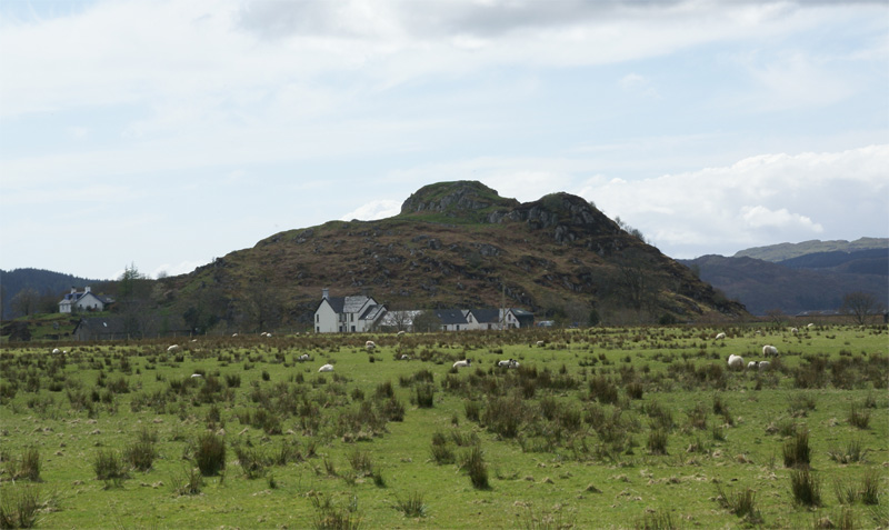
Dunadd is a rocky fort in the Mòine Mhòr, the bog of the River Add, a little north of Lochgilphead in Argyll. Its Scottish Gaelic name, Dún Ad, means the fort on the Add, and the Old Irish name is Dún Att. The crag rises about 54 metres above the moss, and the wet ground, and perhaps the tide, once stood in for an outer wall.
People used the hill long before any Gaelic king. A Neolithic carved stone ball, a Bronze Age potsherd, and cup-marks show earlier visits, and an Iron Age fort occupied the summit, with a date around 410 to 200 BC and further use in the last century BC and the first century AD. The ramparts a visitor sees are mostly later. A dun of the 4th or 5th century AD was enlarged in the 6th or 7th, and again in the 8th or 9th, into a citadel of terraces.
That citadel is bound up with Dál Riata, the Gaelic kingdom of Argyll and north-eastern Ireland. Dunadd is believed to have been its capital in the Early medieval centuries, from about 500 to 800, beside other royal forts and the monastery of Iona. The kingdom’s height under Áedán mac Gabráin gave way to defeats under Domnall Brecc. Selbach mac Ferchair and his son Dúngal mac Selbaig then fought the Cenél nGabráin for the kingship.
In 682 or 683 the fort was besieged in the same season as Dundurn, already a place worth a campaign. In 736 Óengus I of the Picts wasted Dál Riata, seized the fort, and chained Dúngal and his brother Feradach. A further defeat in 741 left the kingdom under Pictish power for a generation. The fort stayed in use into the 9th century, and the summit was occupied again in the 10th to 12th.
What made the rock rich was a 7th-century workshop. Smiths cast brooches in gold, silver, and copper alloy, including forms adapted from Anglo-Saxon work and brooches of Hunterston type, and only the Irish royal site of Lagore has produced nearly as many moulds. Pottery from Gaul, the largest such collection in Britain and Ireland, points to wine, imported food, and gifts sent on to neighbours. Weapons, querns, a cross-marked millstone tied to Iona, and a stone cut with inomine show a Christian household that could both fight and feast.
Below the summit the rock is cut with a basin, a boar in a Pictish manner, an ogham read as naming Finn Manach, and two footprints. The footprints may have been used when a king was inaugurated. The fort was still a place of business in 1506, when commissioners of James IV met there. Digging in 1904, 1929, and 1980 to 1981 recovered the workshop and the sequence of walls.
Images


Detailed History
Dunadd is a rocky fort in Kilmartin Glen, in Argyll and Bute, a little north of Lochgilphead. The crag stands in the Mòine Mhòr, the Great Moor, a peat bog on the flats of the River Add. In Scottish Gaelic the name is Dún Ad, the fort on the Add. In Old Irish it is Dún Att.
The rock is also called Dun Monaidh. It rises about 54 metres above the bog, and the river meanders round its north and east sides before the water reaches the sea at Loch Crinan, about four kilometres away. The mass of rock is roughly triangular, with peaks at the north and west and a broad apron to the south-east. A natural cleft gives the way in from the lower ground.
The bog was once a defence. Land around the rock has since been reclaimed, but the wet ground would have made an approach difficult. The fort may still have stood as an island, or as a promontory in tidal water, in historic times, with the sea falling back in the 6th and 7th centuries and leaving the place more open to siege. Whatever the precise shoreline, the site was chosen because the rock already did much of the work of a wall.
The climb passes through a narrow natural passage and then across terraces. Each terrace once carried a stone rampart. The enclosure on the summit has the strongest position, and it is there that a king is thought to have ruled.
The Early medieval royal centre stood on older use of the same hill. A carved stone ball of Neolithic kind, a sherd of a Bronze Age food vessel, and cup-marks pecked into outcrops show that people were on and around the rock long before any king of Argyll. In 2019 a field search could not find three cup-marks, or cup-and-ring marks, that earlier records had placed here, so those particular marks are now known only from the older notes. The Iron Age left a clearer fort.
Excavation on the summit found rubble that may belong to a wall, with a radiocarbon date of about 410 to 200 BC, and a further occupation in the 1st century BC and the 1st century AD. In northern Europe iron came into common use only around the 5th century BC, so that early summit fort sits near the start of the Iron Age in this part of the world. There is no sign that the hill was a great centre in the Iron Age. The visible ramparts belong mostly to a later rebuilding.
The sequence worked out from the 1980 and 1981 trenches runs in clear stages. A small fort may have stood on the summit in the 4th or 3rd century BC, with further activity later in the Iron Age. A summit dun was built in the 4th or 5th century AD. Further walls were added, perhaps in the 6th or 7th century, and turned the hill into what has been called a nuclear fort, a citadel with dependent enclosures stacked down the slope.
In the 8th or 9th century the summit was enlarged and the lower enclosures extended, and the place reached its greatest size. The summit was used again in the 10th to 12th centuries. After that the rock kept a symbolic role, down to a royal meeting in 1506, but it was no longer the fortress it had been.
Before the 1980 excavations the odd pear-shaped plan of the summit was hard to explain. The digging showed two periods. The earlier fort was an oval about 20 metres by 13 metres inside, with its entrance on the north-east, where a rough path climbs to the top. A later extension to the south-west made the kink in the north-west wall.
A short stretch of the earlier wall was about 3.5 to 4 metres thick, and it overlay still older occupation. On the north-east of the lower plateau the outer wall was sectioned and also proved to have two phases, the first about 2.6 to 3.1 metres thick and the second about 4 to 4.7 metres, both faces battered. On the north-east the same wall still stands about 1.1 metres high in six courses. Elsewhere it is only a band of rubble, or a robber trench where facing stones were taken.
A D-shaped enclosure on the west of the lower fort, about 37 by 20 metres, has a wall about 3.5 metres thick and a small cell in its western angle. Outside, to the north-east, a line of boulders fills gaps between ridges. A cutting in 1981 found no real rampart there, only burnt bone, charred grain, and iron-working debris under the stones.
The kingdom that made the hill famous is Dál Riata, also written Dál Riada or Dalriada. The name is Old Irish and means the portion of Riata. It was a Gaelic kingdom on both sides of the North Channel, covering what is now Argyll and part of County Antrim, at its height in the 6th and 7th centuries. Latin writers called its people Scots, Scoti, a name that had been used for Irish Gaels who raided and settled in Britain, and later for Gaels on either shore.
Argyll itself means the coast of the Gaels. In Scotland the kingdom was divided among four kindreds. The Cenél nGabráin were based in Kintyre, the Cenél nÓengusa on Islay, the Cenél Loairn in the district that still carries Loarn's name, and the Cenél Comgaill in Cowal. Dunadd is believed to have been the capital, and it was a royal power centre of those Gaelic kings from about 500 to 800.
Other royal forts were Dunollie, Dunaverty, and Dunseverick. Within the kingdom stood the monastery of Iona, a centre of learning, of manuscript making, and of the spread of Christian practice through northern Britain. The kingdom had a seafaring culture and a fleet.
The Early medieval period, counted from the late 5th century to the 10th, is the setting for that kingdom. It followed the collapse of Roman power in the west. The Dunadd story is placed in the generations after Roman troops had left southern Britain, while Anglo-Saxon settlement was under way across the North Sea and while Picts and the Gaels of Dál Riata were both powers in the north. One traditional account says the kingdom was founded by Fergus Mór in the 5th century.
Its height is placed under Áedán mac Gabráin, whose reign is given as 574 to 608. In his time the kings sent ships to Orkney and the Isle of Man and attacked the Britons of Strathclyde and the Angles of Bernicia. Æthelfrith of Bernicia stopped that advance at the battle of Degsastan in 603. Serious defeats in Ireland and in Britain under Domnall Brecc, who died in 642, ended what has been called a golden age, and for a time the kingdom was a client of Northumbria.
How Gaelic speech arrived in Argyll is argued. Scottish Gaelic grew out of Old Irish and became a distinct spoken language sometime in the 13th century, though a shared literary language lasted much longer. The common story is that settlers from Ireland brought Gaelic in the 4th and 5th centuries and founded Dál Riata. Ewan Campbell, an archaeologist of this fort, has argued that a migration or takeover is not visible in the archaeology or in place-names, a doubt Leslie Alcock had already raised.
Campbell has questioned the age of the medieval accounts of a conquest. He reads Argyll as part of one Gaelic-speaking world with Ireland, joined by the sea, since the Iron Age. Other scholars defend an early date for the traditional accounts and read the archaeology differently. The fort does not settle that argument, but its name, its ogham, and its workshop all belong to a Gaelic royal centre of the Early medieval centuries.
Old Irish, called Goídelc by its users, is the earliest form of Gaelic with a large body of writing. It was in use from about 600 to about 900, with the main contemporary texts from about 700 to 850, and by 900 it was becoming Early Middle Irish. It is the ancestor of Scottish Gaelic, of Irish, and of Manx. An older stage, Primitive Irish, survives mainly as names cut in ogham on stone in about the 4th to the 6th century.
The ogham at Dunadd is later than those early pillars. It has been read as Old Gaelic rather than as Pictish, referring to a Finn Manach, and dated to the late 8th century or after. The letters use the natural cracks in the rock as a baseline. Unlike many Irish ogham texts, this one long resisted translation, and for that reason it was compared with the unreadable inscriptions of Pictland.
The newer reading pulls it back toward the Gaelic of the kings.
The fort may already have been the chief stronghold by the time it enters the written record. The first notice is a siege in 682 or 683. One reckoning gives 682, another 683. Dún At and Dún Duirn were besieged together, and neither the attackers nor the result at Dunadd were named.
Dún Duirn is Dundurn, a Pictish fort in Strathearn, on a hill above the River Earn. Excavation there found three stages of rampart between about 500 and 800. At the time of the 683 siege Dundurn was held by Bridei III. The pairing of the two sieges shows that Dunadd was already worth a campaign, and that the same season of war reached a major Pictish stronghold.
It has also been suggested that Dunadd was the place where Columba met a merchant from Gaul in the late 500s. That remains a possibility, not a located event.
The internal politics of Dál Riata in the decades before the Pictish conquest turn on Selbach mac Ferchair and his son Dúngal mac Selbaig. Selbach, who died in 730, was a son of Ferchar Fota. He ruled the Cenél Loairn from about 698, probably after deposing his brother Ainbcellach, and he may have been undisputed king of Dál Riata only near the end. In 701 he destroyed Dún Olaigh.
In 712 he besieged Aberte, that is Dunaverty in Kintyre, in the lands of the Cenél nGabráin, and in 714 he rebuilt Dún Olaigh. In 719 he fought Ainbcellach at Finnglen, perhaps near Loch Fyne, and Ainbcellach was killed. A month later Selbach lost a sea fight off Ard Nesbi to Dúnchad Bec of the Cenél nGabráin. Dúnchad Bec died in 721, and Selbach may then have been the unchallenged king.
In 723 he abdicated into a monastery. His son Dúngal succeeded him and was driven out in 726 by Eochaid mac Echdach of the Cenél nGabráin. Selbach left the monastery and fought Eochaid's supporters at Irros Foichnae in 727, and failed to restore his son.
Dúngal mac Selbaig's own reign as king of Dál Riata is best placed in 723 to 726. A later praise poem calls him the Impetuous and gives him seven years. He may have remained king of the Cenél Loairn after he lost the overkingship. In 731 he burned Tairpert Boitir, most likely Tarbert on Loch Fyne, a place in Cenél nGabráin territory and perhaps a portage.
In 733 he dragged a man named Bridei, presumed to be a son of the Pictish king, out of sanctuary on Tory Island. His cousin Muiredach mac Ainbcellaig then became king of the Cenél Loairn. In 734 Dúngal fled to Ireland to escape the power of Óengus. He later came back.
Óengus I of the Picts is the king who broke Dál Riata in these years. Much of his early life is unknown, and he was already middle-aged when the record notices him. He had at least two sons, Bridei, who died in 736, and Talorgan, who died in 782, and two brothers, Talorgan, who died in 750, and Bridei, who died in 763. The Picts were the peoples of what is now Scotland north of the Firth of Forth.
The name Picti appears in late Roman writing from the end of the 3rd century, as an outsider's label, and they have been taken as descendants of the Caledonii and other northern Iron Age groups. Their land was not one uniform people. From the 7th century the kingdom of Fortriu, in the north, came to dominate, and only then does the name seem to have been used by some of them for themselves. Their language was an Insular Celtic speech related to Brittonic, later displaced by Gaelic from the late 9th century.
Much of what is known of them comes from outside, including a life of Columba written by Adomnán, and from Irish chronicles kept in part from notes made on Iona.
In the 730s Óengus fought Dál Riata at a moment when its Irish protectors, the Cenél Conaill, were weak. A fleet from Dál Riata fought for Flaithbertach mac Loingsig in 733 and took heavy losses. Eochaid mac Echdach died in 733, and it is unclear who, if anyone, was overking after him. Fighting between Picts led by Óengus's son Bridei and Dál Riata led by Talorgan mac Congussa is recorded in 731.
In 736 Óengus wasted the territory of Dál Riata. He seized Dún At and burned Creic, and bound in chains two sons of Selbach, Donngal and Feradach. The same war is also told with both Creic and Dunadd taken and burnt. Dúngal, who had returned from Ireland, and his brother Feradach were the men chained.
Their later fate is not recorded. Muiredach of the Cenél Loairn was defeated with heavy loss by Óengus's brother Talorgan mac Fergusa, perhaps by Loch Awe. A last campaign, called the smiting, in 741 defeated Dál Riata again, and the kingdom then drops from the record for a generation.
What was at stake was the survival of a Gaelic kingdom between Irish kindreds, Pictish kings, and Northumbrian power. The fort was not a neutral hill. It has been argued that it stood at the boundary of the kindreds, perhaps even a meeting place for rivals, and also that it was a seat of the Cenél nGabráin and later of the Cenél Loairn. The chained sons of Selbach were leading men of the Cenél Loairn.
Control of the rock meant control of a workshop, a store of imported goods, and a place of ceremony above the glen. Óengus died in 761. A Northumbrian writer of his own century called him a tyrant who perpetrated bloody crimes from the start of his reign to the end. He was succeeded by his brother Bridei.
After a Pictish defeat in 750 his sovereignty was said to ebb, and that has been read as the rise of Áed Find, son of Eochaid, who rejected Pictish overlordship in all or part of Dál Riata. Some scholars see no real recovery after the long foreign domination. Others see a revival under Áed Find, whose dates are given as 736 to 778. Viking raids in Dál Riata begin in 795.
In the next century the crowns of Dál Riata and the Picts may have merged. Some accounts say Cináed mac Ailpín, Kenneth MacAlpin, was king of Dál Riata before he became king of the Picts in 843, after a heavy Pictish defeat by Vikings. The merged realm became the kingdom of Alba. The idea of a separate Pictish kingship lingered a little longer and was given up under Caustantín mac Áeda.
The archaeology of the 7th to 9th centuries shows why the rock mattered while that struggle went on. The 1980 and 1981 work, limited to four small trenches, found a major metalworking shop of the 7th century where the rampart of the lower enclosure had been demolished. The crafts included gold, silver, copper alloys, lead, iron, leather, wood, and stone. Hundreds of fragments of moulds and many crucibles were recovered across the excavations.
Moulds exist for rings, pins, and brooches. Some brooches are of the 8th and 9th centuries. Four moulds would have cast bird-headed brooches. Others match small brooches of a western British kind, and others again resemble pieces in the hoard from St Ninian's Isle.
A slate sketch shows a penannular brooch with expanded terminals and bosses, drawn in part with compasses. Another design, on slate, sets out a large pseudo-penannular brooch with panelled terminals and places for gemstones, close to the Hunterston and Mull brooches. Penannular and pseudo-penannular brooches were both being cast. Some forms were adapted from Anglo-Saxon types.
The quantity of moulds is approached, among known royal sites, only by Lagore in Ireland. The quality of the finished work, including brooches of Hunterston type, has been called unsurpassed. It is possible to see this workshop as one of the places where the Insular art of the northern churches, the art of great illuminated books, was taking shape. That is an argument about a shared style, not a claim that any particular manuscript was made on the hill.
Trade reached farther than the neighbouring glens. The fort has produced the largest collection in Britain and Ireland of a Gaulish pottery known as E-ware, from the later 6th to the 8th century, and the range of imported pottery here has been described as the largest and most diverse from any site in north-west Europe. The vessels are pots, bowls, and jars from Gaul, from the Gironde. They are evidence of wine and of other imported food, and of glass drinking vessels broken among them.
A sherd of a grey wheel-made bowl belongs to another imported class. The rulers seem to have passed these goods on as gifts. A map of the same pottery in Scotland, northern Ireland, and the Isle of Man puts Dunadd at the centre of a cluster in Mid Argyll. A gold-and-garnet stud, or a garnet in a gold setting with filigree, is high-quality Anglo-Saxon work of the 6th or 7th century.
A glass tessera with gold leaf, and a separate gold-and-glass tessera, point to the Mediterranean. An enamelled bronze disc, Germanic glass that may have been scrap for bead-making, a fragment of Roman glass, and an escutcheon from a hanging bowl sit in the same assemblage. A few sherds of samian ware and a spiral finger-ring belong with the earlier, Roman-period finds. The continental pottery, together with radiocarbon dates, places the finest metalworking in a generation of the mid to late 7th century, even though some moulds are of later brooch styles and the rampart that sealed part of the workshop debris was demolished after activity of the 8th and 9th centuries.
The hill was also a place of food and of arms. The early digs found 54 rotary querns or handmills. One is cut with a cross of a kind used at Iona, and it has been argued that the quern was a gift or a render from the monastery, so that flour ground on it was marked with the sign of the cross. A sherd of the Gaulish pottery at Iona is thought to have come from Dunadd.
At least one vessel on the hill had held dyer's madder, a source of purple, the sort of dyestuff used in monastic books. A piece of orpiment, a yellow arsenic sulphide used as a pigment, was also found. With a small stone inscribed inomine, an abbreviated appeal to the name of God, in a script of the 7th or 8th century, the pigment suggests that someone on the site could write and was Christian. Animal bone from the excavations includes fine cuts of beef carried up the rock, the remains of meals for gatherings rather than only of a garrison's rations.
Weapons are unusually many for an early medieval site in Scotland. Parts of more than thirty spears, four arrowheads of which two are crossbow bolts, and a fragment of a sword were found. Not all of them need be relics of a battle. The smithy forged and repaired arms as well as tools.
Knives, shears, and odd slotted iron objects were in the same ironwork. Jet armlets, a composite bone comb, bone pins, a bronze pin, and glass beads are the more personal objects. A mudstone plaque, pierced and worn as if it hung on a cord, is cut with deer, eagles, and knotwork and is placed in the 10th century, among the latest things from the hill. A separate slate motif-piece with animals, a bird, and rosettes is of uncertain date.
On a flat outcrop below the summit, the rock is cut with the signs for which the place is best known. There is a basin, an incised boar, the ogham, and footprints. Two human footprints are cut there. They may have been used when a new king was inaugurated, the foot in the rock standing for his dominion over the land.
Similar footprints are known outside Clickimin Broch. A glass-fibre replica now protects the original carvings. The boar is in a Pictish manner, and it has been suggested that it belongs to the Pictish capture, perhaps to 736. It also lacks some features that would make a Pictish attribution certain.
The basin and the main footprint have been read as part of a royal rite since the 19th century. In 1850 W. F. Skene drew attention to the early references in a lecture at Poltalloch, and in 1876 he identified Dunadd as the capital of Dál Riata.
F. W. L. Thomas discussed the footprint as an inauguration mark and did much to fix that idea in the popular account.
Many of the passages they used refer to Dun Monaidh, and Watson later rejected the assumption that those passages mean this rock. The excavation report of 2000 still treats the inauguration case as strengthened by the finds, not as closed. A rock-cut feature has also been read as a throne. A well on a terrace, lined and paved, was later tapped to supply a farm, and a St Columba's well has been noted at or near the fort.
A second, lightly cut animal, with an upright tail, is recorded on a cleft wall.
The fort was still occupied after 736, at least into the 9th century, and the summit saw use in the 10th to 12th centuries. It is named again in the later Middle Ages, which suggests that memory of the place outlived the kingdom. In 1436 Alan, son of John Riabhach MacLachlan of Dunadd, was made seneschal of the lands of Glassary. The chief house of the MacLachlans of Dunadd stood below the fort, not on the summit.
In June 1506 commissioners appointed by James IV, among them the earl and the bishop of Argyll, met at Dunadd to collect rents and to settle feuds. That meeting is the last clear use of the rock as a place of royal business.
Seven kilometres to the north, at Bruach an Druimein, quarrying in the 1960s exposed a Bronze Age cist cemetery, two Iron Age round houses, and early medieval objects of the same age as the royal fort. Two glass beads from that settlement have a chemical composition like beads from Dunadd. The excavators took the beads to have come from the fort, and the settlement to have been associated with it or controlled from it. The comparison matters because it shows the hill as the centre of a district, not as an isolated citadel.
Kilmartin Glen around it is one of the densest prehistoric ritual landscapes in Britain. The royal fort was planted in that older country, whether or not the kings chose the spot for that reason.
Antiquaries and archaeologists have opened the hill three times. David Christison published the first detailed description in 1904, after his fieldwork on the forts of this part of Argyll in 1903. The digging ran from May 1904 to January 1905 under Alexander MacKie, a clerk of works. Christison worked from MacKie's notes and weekly letters, from plans by Thomas Ross, and from photographs.
He did not visit during the dig, because the distance from Edinburgh kept him from the usual supervision. The team, perhaps four men for about fourteen weeks from October to January, followed walls and turned over the interior. J. H.
Craw returned in 1929, working twenty-four days between late May and early July with two local men, to look for the stratification Christison had missed. He cut a trench in the summit, a midden in a gully where nettles grew thick, and a rich deposit in the middle enclosure. He found no clear sequence in the artefact soil, suspected that the 1904 work had already turned it over, and did not label his finds, so their positions are less well known than the earlier ones. He did recognise that the moulds and the wheel-made pottery resembled material from the Mote of Mark.
He thought further digging would find objects but little stratigraphy, and he doubted it was worth doing.
The 1980 and 1981 excavation, directed by Alan Lane, was deliberately small. Its first aim was to date the defences, in a debate about the age of nuclear forts, and its second was to see whether undisturbed ground remained. It sat within Leslie Alcock's wider series of short excavations on early historic royal sites. Four trenches answered the structural question and, in the third of them, revealed the 7th-century workshop.
In 2000 Lane and Campbell set out the chronology, the brooch moulds, the imports, and the case for inauguration. Earlier, R. B. K.
Stevenson had taken the plan as the type of a nuclear fort, a citadel of the early historic period. R. W. Feachem had instead seen an Iron Age fort whose walls might have been patched by later and perhaps desperate hands into the 7th century.
The radiocarbon dates and the imports decide that argument toward an early medieval royal centre built over a thinner Iron Age use. The finds from Christison and Craw went to the national collection in Edinburgh, and Lane's finds were to go there after conservation.
The rock is an ancient monument in state care. By 2022 it had been legally protected for ninety years. It is free to visit and open year-round. There is no entrance fee.
In June 2020 a member of the public reported metal-detecting and digging. The court later heard that 28 holes had been dug, and the police recovered an iron hammerhead, extremely fragile, that had been taken from the site. In June 2022 two men were sentenced for the damage. The loss is not only the objects.
An object lifted without record is cut off from the layer that dated it. In October 2022 a measured survey and photogrammetric record were made of a short length of walling outside the north-eastern rampart, on steep bedrock, identical in build to the main wall. It had not been recorded before. The working idea is that it levelled a stance above one of the ways in, perhaps as a place to watch the approach, and it was drawn because it might slump.
That is the most recent structural observation on the hill. It adds an outer platform to a fort whose main sequence was already known, and it shows that even a repeatedly excavated rock still holds unmapped stone.
Later writers have used the fort as a setting. Rosemary Sutcliff, the English novelist of historical stories for children and for adults, published The Mark of the Horse Lord in 1965. In that book the people of Dál Riata struggle over the royal succession. A fort called Dun Monaidh stands at the centre, and a coronation uses a carved footprint.
Twenty years on, the novel was chosen for an award given to a children's book that had missed the main prizes when it first appeared. Claire R. McDougall's novel Veil of Time places a modern woman at the fort in its 8th-century heyday, and it uses the footprint, the boar, the well, and the fallen walls. None of that fiction is evidence for a rite or a siege.
It does show how the footprint and the boar, once argued over by scholars, became the images by which the rock is recognised.
A separate modern label should not be mistaken for part of this history. Audio Video Interleave is a container for sound and picture in a computer file, introduced in November 1992. It has no bearing on the kings, the ogham, or the date of the walls. The history that the rock will support is the one in the dated events and in the trenches: an Iron Age summit, a Gaelic royal fort of Dál Riata, a 7th-century workshop tied to Gaul and to Anglo-Saxon metalwork, a capture by Óengus I of the Picts in 736, and a long afterlife as a place of memory above the moss.
Sources
- Dunadd — Wikipedia
- Picts — Wikipedia
- Dál Riata — Wikipedia
- Óengus I of the Picts — Wikipedia
- Selbach mac Ferchair — Wikipedia
- Dúngal mac Selbaig — Wikipedia
- Dundurn, Scotland — Wikipedia
- Rosemary Sutcliff — Wikipedia
- Old Irish — Wikipedia
- Scottish Gaelic — Wikipedia
- Early medieval — Wikipedia
- Iron Age — Wikipedia
- Audio Video Interleave — Wikipedia
- Kilmartin Glen: Dunadd Fort, history and stories — Historic Environment Scotland
- Kilmartin Glen: Dunadd Fort, plan your visit — Historic Environment Scotland
- Dunadd — Historic Environment Scotland
- Dunadd Digital Archive — University of Glasgow
- Dunadd Hillfort: the seat of early medieval Scottish power — National Museums Scotland
- Metal detectorists admit taking item from Iron Age Dunadd Fort — BBC
- Dunadd Fort 20080427.jpg — Wikimedia Commons
- Dunadd, Argyll.jpg — Wikimedia Commons
- Dunadd Fort - view.jpg — Wikimedia Commons
- Dunadd Fort 20080427 - entry to upper levels.jpg — Wikimedia Commons
- Dunadd Fort 20080427 - footprint.jpg — Wikimedia Commons
- Dunadd Fort 20080427 - well.jpg — Wikimedia Commons
- Dunadd Fort 20080427 - highest level.jpg — Wikimedia Commons
- Dunadd Fort, Kilmartin - geograph.org.uk - 1498.jpg — Wikimedia Commons
- Dunadd - geograph.org.uk - 421315.jpg — Wikimedia Commons
- Dunadd - the 'inner fort' - geograph.org.uk - 421337.jpg — Wikimedia Commons