
Orkney Islands, United Kingdom · Neolithic · United Kingdom
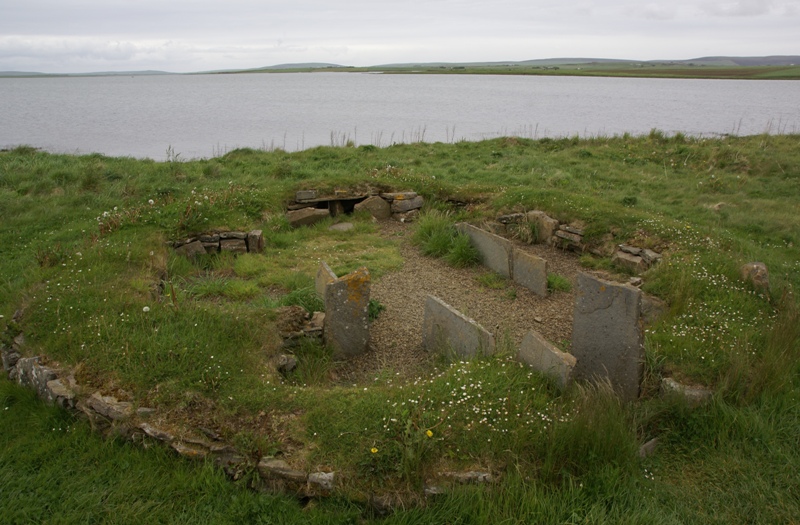
- A late Neolithic village stood on the shore of the Loch of Harray, a short walk north of the Standing Stones of Stenness.
- Colin Richards found it in December 1984, and excavation from the mid-1980s to 1991 uncovered free-standing stone houses with hearths, box beds, and dressers.
- Modelled dates put the occupation in the later thirty-second century BC through the earlier twenty-ninth, while older accounts use about 3000 BC and an abandonment around 2600 BC.
- House 2 was the large early building, and Structure 8, raised near the end on a clay platform, was tied to the Stones of Stenness and to Maeshowe.
- The pottery is among the earliest Grooved Ware yet dated, and the finds include Arran pitchstone, maceheads, flint, and burnt bone of deer and cattle.
Visiting
The site is open all year round, and guided walks of the settlement are available throughout the year.
History
Barnhouse Settlement is a late Neolithic village on the shore of the Loch of Harray, a short distance north of the Standing Stones of Stenness on the Mainland of Orkney. The houses were free-standing, with central hearths, beds against the walls, stone dressers, and drains, and they were not packed in midden as the later houses at Skara Brae were. Colin Richards found the settlement in December 1984, and excavation from the mid-1980s to 1991 uncovered the base courses of a village that ploughing had damaged.
The place was founded on fresh ground in the later thirty-second century BC. A modelled chronology puts the start in 3160 to 3090 cal BC, or in a smaller share of the probability in 3080 to 3045, and a combined reading of the first houses gives 3125 to 3090 cal BC, probably 3115 to 3095. Older accounts place the village around 3000 BC, or before 3000 BC, and its abandonment around 2600 BC. The new model ends the occupation in 2890 to 2845 cal BC, probably 2885 to 2860, after a span that is probably 225 to 275 years.
House 2 was the large early building, twice the size of its neighbours, with fine masonry, two hearths, and a cist that held scraps of bone. Smaller houses stood around a central work area where pottery, flint, bone, and hides were worked, and a second meeting place lay south of House 2. The houses were rebuilt on nearly the same plots across several generations. Counts of the buildings differ: thirteen structures were excavated, while other accounts say at least fifteen houses, a maximum of twelve, or at least eight house sites and a large hall.
Structure 8 was raised near the end, in 3010 to 2955 cal BC, probably 3000 to 2975, over the levelled remains of House 9. It was a square building with rounded corners, walls about 3 metres thick, and a room of about 7 metres or 8 metres, set on a clay platform inside an outer wall. Before it was built, the hearth of the open southern meeting place was carried to the centre of the Stones of Stenness. The building was probably the last part of Barnhouse to be left, in 2915 to 2870 cal BC, probably 2905 to 2880.
The pottery is Grooved Ware, about 6,000 sherds in the finished assemblage, and among the earliest of that tradition yet dated. Decoration is mostly incised, including a band of three wavy lines, and large coarse cordoned pots appear late, from about 3025 to 2975 cal BC. The finds include flint, four maceheads, burnt bone of deer and cattle, and pitchstone from Arran, counted as one piece, as several pieces, or as 26 pieces. A stone with carvings like those at Skara Brae and Maeshowe was also found.
The village lies in the Heart of Neolithic Orkney landscape, inscribed on 2 December 1999, placed by one account in the buffer zone and by another within the World Heritage Site. It showed that people were living among the monuments, and its large houses belong with the Stones of Stenness, Maeshowe, and the Ness of Brodgar. The lower walls visible now are the reconstructed base courses of that ploughed settlement. The site is open all year round.
Images


Detailed History
Barnhouse Settlement is a late Neolithic village on the shore of the Loch of Harray, on the Mainland of Orkney. It stands a short distance north of the Standing Stones of Stenness, about five miles north-east of Stromness, at the southern end of the freshwater loch. One measured account places the houses about 150 metres north of the stone circle. Another says the walk is a little more than a hundred metres.
The ground is the north-eastern tip of the Stenness promontory, where the freshwater Loch of Harray meets the brackish Loch of Stenness. Maeshowe lies to the east, and the Ness of Brodgar and the Ring of Brodgar lie to the north, on the narrow isthmus between the two lochs.
The village belongs to the monumental landscape now called the Heart of Neolithic Orkney. That group was inscribed as a World Heritage Site on 2 December 1999. The four named monuments are Maeshowe, the Standing Stones of Stenness, the Ring of Brodgar, and Skara Brae. One account of the nomination places Barnhouse in the buffer zone, as a domestic site needed to understand the monuments around it, and says the settlement had started before 3000 BC.
Another account describes the village itself as part of the World Heritage Site. The houses sit inside the protected Brodgar landscape, and they were built for comparison with the great tombs and circles rather than as one of the four named monuments.
Before the village was known, the ground around the Ness was often treated as a ritual landscape only, a place of tombs, standing stones, and circles kept apart from ordinary living. The houses at Barnhouse showed that people were dwelling among those monuments. The settlement also added a kind of site that had been missing from the sketch of Neolithic Orkney: a place founded new, on ground with no earlier village beneath it, and occupied for a few centuries rather than for the long span of Skara Brae.
The Stone Age is the broad age in which this happened. It was the long prehistoric stretch in which stone was shaped into tools with an edge, a point, or a striking surface. It lasted for roughly 3.4 million years and ended between 4000 BC and 2000 BC, as metalworking took over. In western Asia that change was under way by about 3000 BC.
The Stone Age is the first part of the three-age scheme, followed by the Bronze Age and the Iron Age, and it is commonly split into the old, middle, and new stone ages. Bone tools were used as well, though they rarely survive. Simple cold-worked gold and copper were already known for ornament, but the melting and smelting of copper is what ends the age. Barnhouse sits at the far end of that age, in the Neolithic, when farming, herds, pottery, and large stone monuments were already established in these islands.
Prehistoric Orkney, in the sense of human occupation of the archipelago, runs until the start of the Early Historic Period in northern Scotland, around AD 600. The islands are unusually rich in prehistoric remains, especially from the Neolithic. Sandstone splits into workable slabs. Wind-blown sand has sealed some sites.
Industry and deep ploughing have been lighter here than in much of Britain, and local feeling about the old stones, perhaps carried over from the Norse centuries, has sometimes kept people from pulling them apart. The boundaries of the periods are not sharp. In general the Paleolithic lasts until the ice retreats, the Mesolithic until farming, and the Neolithic until metalworking. Orkney has nearly 3,000 identified Neolithic sites.
The Neolithic in Scotland runs from about 4000 to 2200 BC. Elsewhere in Britain the early Neolithic is often set apart from a later Neolithic of new, wider traditions and grander building. In Orkney the change is slower, and later work tends to grow out of earlier ideas. The great Orcadian monuments were raised almost a thousand years before the sarsen settings at Stonehenge.
The earliest Neolithic houses in Orkney were timber. Stone walls replaced them in the century or two before Barnhouse, though that change is still loosely dated. At Knap of Howar on Papa Westray, at Green on Eday, at the Knowes of Trotty, at Stonehall Meadow on the Mainland, and probably at Wideford Hill, single houses grew into double units. At Braes of Ha’Breck on Wyre and at Brae of Smerquoy on the Mainland, houses were lengthened instead.
Stonehall and Braes of Ha’Breck also show the first clustering, with stone houses at Stonehall some 50 to 100 metres apart. Most of those Mainland sites lie in the long-settled Bay of Firth. Barnhouse is different. It sits in the natural bowl of western Mainland, among settlements and monuments that are mostly a little later than its own foundation.
Western Mainland, away from the north coast, has few early stalled chambered cairns. Most of the tombs here are later passage graves, and many of them crowd the Stenness and Brodgar ground. On the south-east shore of the Loch of Stenness stands the chambered cairn of Unstan, which is presumed to be older. The long horned cairn of Staneyhill, to the north, could belong to the third millennium BC.
At Deepdale, south-west of the Loch of Stenness, small and seemingly short-lived settlements go back to the late Mesolithic. Round-based bowl pottery in the lower deposits at the Ness of Brodgar shows that people were already living nearby when Barnhouse was founded. A substantial late Neolithic settlement at Buckan, or Bookan, fits a wider spread of settlement onto the heavier inland soils. Barnhouse is an early part of that spread, and an early part of the Grooved Ware sequence.
Knap of Howar may be the oldest preserved stone house in northern Europe. Radiocarbon dates put its occupation between 3800 BC and 2800 BC, earlier than the houses at Skara Brae. Two thick-walled buildings stand side by side, with low doorways toward the sea, a hearth, a stone cupboard, beds, and storage shelves. The walls still rise to about 1.6 metres.
The midden shows cattle, sheep, and pigs, barley and wheat, shellfish, and line-caught fish. The roofs are gone. They were probably of wood, thatched or turfed. There were no windows.
Fire would have lit the rooms, and a hole in the roof would have let the smoke out. The farm stood on an earlier midden, and midden later wrapped the walls and preserved them. That is the older pattern of a stone farm. Barnhouse, centuries afterward, used some of the same furniture and a different plan.
The village was found in December 1984 by Colin Richards. A discrete scatter of flint, burnt bone, and stone lay beside the Loch of Harray, covering about 65 by 90 metres. In March 1985 a full surface collection and a geophysical survey produced a large amount of worked flint, burnt animal bone, two polished stone axes, and a single piece of pitchstone from the Isle of Arran. Under the ploughsoil, patches of undisturbed Neolithic ground still held the lowest courses of cellular stone buildings, like the early houses at Skara Brae.
Drystone walling bounded areas of redeposited clay, some of it burnt. Pits and hearths lay outside the buildings. The early finds included about 180 sherds of Grooved Ware, about 100 flints, burnt bone of deer and of cattle, a fragment of a polished stone axe treated as an import, and stone knives, pot lids, and hammerstones. The decoration on that early pottery was made only by incision, the manner of the earliest phase at Skara Brae, and both the decoration and some of the fabrics matched pottery from the Stones of Stenness.
A trial excavation showed a substantial Grooved Ware settlement that annual ploughing was destroying. The main digging then ran through several seasons. One account places the excavations between 1986 and 1991. A later dating of the same layers places the digging in 1985 to 1991.
Another season-by-season account gives three seasons from 1986 to 1988, with further work in 1989 guided by questions about the great outer building. A designation of the wider monument says the settlement was partly excavated in the early 1980s. Those accounts do not agree, and all of them are part of the record. The first season recognised four structures in a small trench that was only part of a larger complex.
The second season reported ten stone houses on the promontory. By the end, the base courses of at least fifteen houses had been traced in one reckoning. Another reckoning is a maximum of twelve buildings. The designation counts at least eight house sites and one large late Neolithic hall.
The dating study says thirteen structures were excavated, with their refuse and the ground between them. Geophysical survey still hints that the settlement was larger than the dug area, and the designation says unexcavated evidence extends well beyond it. Some houses may have been lost to the rise of the Harray loch, and others to historic ploughing.
The houses were free-standing. They were not joined by roofed passages, and they were not packed in midden, which is how the later houses at Skara Brae survive. They were small and round, with stone walls and turf. Turf cladding on the outer walls would have made them look like low grassy mounds, with smoke at the roof and the door.
They share the early Skara Brae plan: a central hearth, beds built against the side walls, a stone dresser opposite the entrance, and an internal drain. One early house had six rectangular recesses set into the inner wall, a hearth to the right of the entrance, and a cist with a cover slab in the centre, in line with the door. V. Gordon Childe, who excavated Skara Brae from 1927 and also worked on the chambered tombs of Maeshowe and Quoyness, described slight early huts there which he thought had been replaced by larger and more solid buildings.
The Barnhouse houses resemble those earlier huts. They also went out of use some four centuries before Skara Brae ended. Skara Brae was occupied from roughly 3180 BC to around 2500 BC. One account says Barnhouse stopped being used about 400 years before Skara Brae ended.
Another says the Barnhouse houses went out of use some four centuries earlier. The two settlements were contemporary for a time, and then only Skara Brae went on.
From the first phase the place was organised, not a scatter of huts added at random. A large house, House 2, stood among at least six smaller houses of the early Skara Brae and Rinyo kind. That order held while the settlement lasted. House 2 was later remodelled inside.
The smaller houses were rebuilt, and the settlement grew by at least seven further houses. Another reading of the plan is two rings of buildings around a central open area, the inner and outer rings each served by its own drains. Marked differences in the objects from the two rings have been argued as a social division between households. The drains of the inner arc show Houses 7, 12a, and 13a earlier than Houses 6 and 10.
During the dig it was thought that the outer arc, Houses 9, 2, 3, and 5a, might be later than the inner arc, but every one of those houses was set on glacial till, and no clear sequence from inner to outer survived in the phasing.
House 2 was the outstanding building of the outer arc. It was twice the size of the other houses, apart from the later monumental building, and its masonry is of a quality otherwise seen in buildings at the Ness of Brodgar and in passage graves such as Maeshowe and Howe. It used a piered interior and had two hearths. Inside it, fine objects were made and set down, including maceheads and axes.
A slab-covered cist held scraps of bone that may be human or animal. One account says House 2 was double-sized, built to a higher standard than the other houses, rebuilt as many as five times, and kept in use throughout the life of the settlement. The later chronology agrees that it was founded at the start and maintained for a very long time, but it also allows that House 2 went out of use before the settlement ended, sealed by a dark soil rich in objects. That soil is hard to read.
It may instead be the last use of the building, in which case House 2 lasted to the end. Both readings remain open. Certain decorative schemes on the pottery occur only in House 2.
The houses stood around a central open area. It was divided into places for making pottery and for working flint, bone, and hides. Ash and debris from that work were dumped on the ground and kept a spatial order. The work area was maintained through the life of the village and spread over the demolished House 7, where there is also evidence that Grooved Ware was made.
A second open meeting place lay outside the houses, south of House 2. There the activity centred on a large rectangular stone hearth, 2.15 by 1.9 metres. The size of that hearth, and the quantity and trampled state of the pottery, point to gatherings at which food was prepared and eaten on a scale beyond a single household. Because the place was at the edge of the village, associated with Barnhouse but not in the middle of it, it may have been neutral ground where visitors from farther off could meet.
Almost all of the pitchstone from the settlement came from these two meeting areas.
Preservation varied. Houses nearer the loch were protected by a positive lynchet. Houses farther inland were badly eroded. In the north-western part of the great outer building, ploughing had removed the walls and much of the clay floor and the surrounding platform, leaving only the soil-filled impressions of stones.
The early excavators already saw that the settlement was different in construction from the midden-buried villages of Orkney. The designation calls it an exceptionally fine settlement of the period of the first phase at Skara Brae, and of national importance, within a wider protected area that also holds the Watch Stone, the site of another monolith, the traditional site of the Odin Stone, and traces of later use from prehistory into the early Christian period.
The objects are the domestic kit of a late Neolithic house, with a few things brought from far away. Flint and other stone tools were abundant. Four maceheads came from the excavation as a whole. An early season also reported a macehead, skail knives, and stone axes.
A cache of fourteen large flint nodules was later found in a pit cut into the clay floor of the great outer building. Pumice was used on the platform of that building. Burnt bone of deer and of cattle was plentiful in the early seasons. Unburnt bone did not survive in the deposits, so the dating programme had to use calcined bone and scarce charred plants.
The wood charcoal is mostly heather, hazel, and birch, with a little driftwood, oak, and ash. Cramp across the site probably means that seaweed was also burned as fuel. A stone bearing carvings like those at Skara Brae and Maeshowe was found in the settlement. One Beaker rim, from an upper deposit under the topsoil, is the only pottery that falls outside the Grooved Ware tradition, and it belongs to a later visit rather than to the life of the village.
Pitchstone is a volcanic glass, similar to obsidian. The nearest source is the Isle of Arran, off the south-west coast of Scotland. The 1985 collection produced a single piece. The early digging called the worked pitchstone the first from Orkney.
The full excavation found several pieces. A later count is 26 pieces from Barnhouse, against 42 from the Ness of Brodgar, which is now the largest assemblage in Orkney. Before the Ness was dug, Barnhouse was the only Orcadian site known to have yielded it. The pieces had to be carried to Orkney.
They gathered in the meeting areas, which has been taken to mean that those places were where unusual objects were shown and exchanged.
The pottery is Grooved Ware, the flat-based, straight-sided style of the later British Neolithic, sometimes with walls that splay outward and with grooves around the top. Its makers are sometimes called the Grooved ware people. Unlike Beaker pottery, it was not brought from the continent as a finished tradition. One account says it developed in Orkney early in the third millennium BC and was soon taken up in Britain and Ireland, perhaps growing out of earlier Unstan ware bowls.
The Barnhouse dates put a large assemblage of it earlier than that summary, in the later fourth millennium, and among the earliest Grooved Ware yet dated anywhere in its wide distribution. It was once called Rinyo-Clacton ware, a name given by Stuart Piggott in the 1950s after Rinyo on Rousay and a site at Clacton that now lies under the sea. The style was used by the builders of the first phase at Stonehenge, and it is abundant at Durrington Walls and Marden. Some very large pots, up to about 30 gallons, could have held drink for a feast.
Most are jug-sized or cup-sized. At some henges the pots may have been ritual as well as practical. Chemical work on pots from Balfarg in Fife has been read as evidence that some of them held black henbane. That finding is not claimed for Barnhouse.
At Barnhouse the finished assemblage is about 6,000 sherds, perhaps 200 to 300 pots. That is a different figure from the 180 sherds of an early season, which recorded only what had been found by then. Most sherds lay outside the houses, sometimes in material that looks as if it had been cleared out of a house, or in later fills from reoccupation. Few lay on the original floors.
The usual shape is a tub or a bucket. There are also shallow bowls, and a tiny pinch-pot from the drain of the great outer building, like the small ochre-mortars known elsewhere in late Neolithic Orkney. A stone example of such a mortar is known from Barnhouse itself. Three sizes were defined, by rim diameter: small, 140 to 210 millimetres; medium, 211 to 280; and large, 281 to 420.
Walls thicken with size, from about 5 to 9 millimetres on the small pots, 9 to 15 on the medium, and 16 to 30 on the large. Where pottery can be tied to a building, more than one size is usually present, and sometimes all three. Large pots dominate on the platform of the outer building, and their surfaces are often less carefully finished.
Decoration is by incision, impression, and applied cordons and pellets. Incised lines are the most common. On 73 per cent of the decorated sherds the leading design is a band of three parallel wavy lines, a serpentine pattern, often with bands of horizontal lines. Narrow, fine cordons sit on carefully finished pots and may be applied or made in false relief.
Thicker cordons sit on coarser pots and are always applied. A wavy false-relief line, made by alternating depressions, is used again and again. Stab marks appear as rosettes, as fringes on incised lines, and as fillers for triangles or lozenges. One sherd from the inner building of the great outer structure has cross-hatching between diagonal lines.
Where a whole pot can be seen, the decoration does not cover the entire body. On the large pots it is usually only the zone under the rim. It was not possible to say how many pots had no decoration at all. The base of one pot from House 3 carries the impression of spiral-coil basketry matting.
The mat was already old and quite tattered when the pot was set on it.
Six fabrics were distinguished by the amount and kind of filler. Some pots have no deliberately added material. Others have shell, or stone, or both. Small pots tend to have little filler, or a moderate amount of shell.
Medium pots have a moderate amount of stone or shell. Large pots have a moderate or large amount of stone, sometimes with a little shell. Shell-filled sherds concentrate in the midden on the east-central part of the site, and a place where such pottery was made was found on the levelled site of House 7. In the western houses, each house used its own recipe of stone types.
The pottery in the great outer building contains the full range, and the stone comes from sources around the lochs of Harray and Stenness, all within about 10 kilometres. An earlier reading took that mixture as a change to communal potting. The new chronology sets that reading aside. Several houses were still in use when the outer building was raised, so pots made in those houses could have been carried in and left there.
The different recipes still need an explanation. They may mark pots made for different tasks and different social settings. Houses 6 and 7 used only shell.
Across more than two centuries the pottery is strikingly consistent. Small, medium, and large pots, incised and impressed decoration, the false-relief wavy line, and both shell and stone filler run from the beginning to the end. Applied decoration is present from at least the earlier thirtieth century BC, as on a splayed vessel from House 6. The clear late change, from about 3025 to 2975 cal BC, is the appearance of large coarse pots with uneven surfaces and thick applied cordons, and of applied dimpled circular pellets.
The impressed rosette seems to stop by the time the great outer building was raised. Those coarse pots lie in the upper midden and in and around that building.
The first radiocarbon programme, twelve measurements on single fragments of short-lived charred plants, placed the site somewhere in the broad span from about 3500 to about 2900 cal BC, and so at or near the start of Grooved Ware. A fresh programme in 2013 to 2015, led with Colin Richards by Andrew Meirion Jones, Ann MacSween, Alison Sheridan, Alex Bayliss, Alasdair Whittle, and their colleagues, produced 62 new results. The model uses 70 of the 74 dates now available, on 62 samples, of which 50 are thought to date the deposits they came from. Twelve are treated as residual, and a few results were set aside as inaccurate or intrusive.
Material was scarce. Unburnt bone was gone. Charred plants were rare. Residues were scanned for on every pot.
Calcined bone could be dated, but for some houses, including Houses 6 and 10, nothing datable could be found. The inner arc is poorly sampled. No sample could be found from House 6, which lies in the sequence between Houses 7 and 11. The deposits are shallow, at most 0.6 to 0.7 metres, but there were enough relationships between walls and midden to build a stratigraphic model.
Dates on calcined bone and on charred plants agree closely enough that a fuel offset is not treated as a serious problem here, even though seaweed may have been burned.
On that model, habitation began in 3160 to 3090 cal BC, at 86 per cent probability, or in 3080 to 3045 cal BC, at 9 per cent, and probably in 3135 to 3100 cal BC. The first houses were Houses 2 and 9, built in 3140 to 3035 cal BC, probably in 3130 to 3070. They share a drain and have opposed entrances, so the model treats them as one building event. House 3 was built at the same time, in 3145 to 3080 cal BC at 83 per cent probability, or 3070 to 3030 at 12 per cent, and probably in 3125 to 3095.
The work area began to collect craft waste in 3140 to 3080 cal BC at 84 per cent, or 3070 to 3035 at 11 per cent, and probably in 3125 to 3090. The order among these first elements cannot be settled. It is about equally likely that House 3 came before the work area or the other way round. The undated first phase of House 5, called 5a, almost certainly belongs to this opening.
Its second phase began in 3125 to 2955 cal BC, probably in 3105 to 3015, an estimate that rests on only three dates. Houses 2, 9, and 3 are structurally linked, and one drain network joins them to House 5a. If those elements were a single foundation, the combined estimate is 3125 to 3090 cal BC, probably 3115 to 3095. That is the figure behind the rounded dates of about 3115 BC for the start.
It can be read as a planned foundation, a choreographed construction, though the model allows that reading and does not prove it.
House 7 was probably a little later, in 3130 to 3025 cal BC, probably in 3120 to 3060. House 6 was built farther north, after House 7, because its drain cuts the drain of House 7. House 1 was added to House 6 while House 6 still stood. Neither has a radiocarbon date.
Both were out of use before House 11, which was built in 3000 to 2920 cal BC, probably in 2975 to 2930. Houses 4, 10, and 12 have no formal date estimates. House 12 has one date, probably on a residual sample. Like many of the houses it was rebuilt at least once.
The first House 12 stood on the till. The second was slightly offset and partly covered midden. House 12a came before the neighbouring House 10, which was never remodelled, and House 10 probably sits between 12a and the rebuilt House 12. House 12a on the till may be close in date to Houses 7 and 6.
House 4 is late. It lies on deposits that built up while House 3 was in use. A short stretch of the wall of House 13, also on the till, may have stood with House 7, because the drain around House 7 respects that wall. The later House 13b was built more like Houses 10 and 6.
A house that went out of use was replaced, but the new building was never on exactly the same spot. It always partly overlay its predecessor. That habit of rebuilding on a house site, sometimes with stone from the older walls, keeps a physical link with the people who had lived there. Founding Barnhouse on unused ground then looks deliberate, a visible break with an older place.
In 2005 the excavators thought the village stood alone, apart from a suspected Mesolithic presence nearby, and that the first villagers would have seen only the remains of an earlier building, possibly a house, on the spot where Maeshowe was later raised. That picture has changed. When the first Barnhouse walls went up, earlier buildings at the Ness of Brodgar, about 400 metres away, had already been standing. One of them, Structure Five, is dated to about 3300 BC, a century before Barnhouse.
The Ness as a whole has activity from around 3500 to 3400 BC in one account, and buildings of about 3000 BC in another. A shift of settlement north along the Loch of Harray, from some older site to Barnhouse, has not been ruled out.
If a generation is taken as 25 years, the occupation is a continuous hold on one place for probably about ten generations. Stone walls needed only ordinary repair. Roofs must have been renewed more often. Nothing required the builders, at the start, to imagine a future of centuries.
Choosing to repair a house on the same footprint, rather than to move, was a social decision. House 5 was rebuilt on four major occasions, in almost the same position, at intervals of roughly fifty years, or about every two generations, across the life of the settlement. House 3 was not rebuilt as a new shell. It was refurbished, and its floor was renewed at least twice.
One account says House 2 was rebuilt up to five times. The duration model draws a contrast between the founder houses, which stayed, and the later houses added to the east, which partly filled the original work area and did not last as long.
House 9 went out of use in 3020 to 2970 cal BC, probably in 3010 to 2985, after 35 to 155 years, probably 70 to 135. It was demolished to make way for the great outer building, and its stone was robbed for that work. House 7 ended in 3060 to 2965 cal BC, probably in 3020 to 2985, after 20 to 135 years, probably 45 to 110, and its masonry was also completely robbed. The two endings belong to the same moment, and both may be the cost of clearing ground and stone for the new building.
House 11, the latest dated house to be built, ended in 2980 to 2910 cal BC, probably in 2955 to 2915, after a short life of 1 to 50 years, probably only 1 to 20. Houses 2 and 3, and the work area, were kept into the final decades of the thirtieth century BC. House 5 may have lasted that long as well, though the estimate for its end applies only to the end of phase 5b. The whole settlement was occupied for 165 to 205 years at 9 per cent probability, or 210 to 295 years at 86 per cent, and probably for 225 to 275 years.
Final activity falls in 2890 to 2845 cal BC, probably in 2885 to 2860. Rounded figures in other accounts say the village was in use from about 3115 BC until 2875 BC, or until about 2874 BC, or that it was abandoned around 2900 BC, or around 2600 BC. The older abandonment, around 2600 BC, and the start around 3000 BC, are the broad dates given before the new model. The modelled end sits in the earlier twenty-ninth century, not in the twenty-sixth.
The change that reordered the site was Structure 8, also called Structure Eight. It is a large square building with rounded corners, partly set over the levelled remains of House 9, and partly over earlier building ground. One account places it after the village had already been abandoned, and treats it as a ceremonial building rather than a house. Another says it was raised while other houses were still in use, and that the whole nature of habitation changed, so that Barnhouse was no longer functioning as a village, though some ancillary living may have continued, and a flint scatter to the south and east may mark people moving off the original plots.
The buildings probably still standing after it went up include Houses 1, 2, 3, 4, 5, 6, 10, 11, 12b, and 13b.
It was built in 3010 to 2955 cal BC, probably in 3000 to 2975, which is 60 to 180 years after the foundation, probably 110 to 155 years. That is the figure behind “about two centuries after the founding” and “just after the turn of the millennium.” It is later than every dated domestic building except House 11, which is probably later still, at 88 per cent probability. It was probably the last element to be abandoned, at 66 per cent probability, in 2915 to 2870 cal BC, probably in 2905 to 2880. Its own use lasted 60 to 130 years, probably 80 to 115.
One account gives the abandonment of this building as the span 2905 to 2880 BC.
Around 3000 BC, before the building went up, the hearth of the southern meeting place was taken apart and its stones were carried about 205 metres south-west, to the centre of the Standing Stones of Stenness. One account says some of the hearth slabs may have been moved to the stones. Another says they were set in the centre of the circle, an act that tied the village to the monument. The site of the old hearth was then built into Structure 8 as its central fireplace.
The position of the new building was fixed by that hearth. What had been an open meeting place became a meeting place behind walls.
The inner room is about 7 metres across in the early trench account, and an eight-metre square in a later description of the interior. The walls are about 3 metres thick. The building stands on a circular raised platform of yellow clay, enclosed by an outer stone wall. That outer wall is 1.5 metres thick and 26 metres in diameter in the 1988 account, about 1.3 metres thick in the dating study, and 1.4 metres thick in a later description of the same circuit.
One course of well-built sandstone survived. Given the width and the size of the blocks, the wall could have stood more than two metres high. If it did, it would have hidden the platform and cut off the view. It may instead have been lower and more symbolic.
An entrance was built into it, which argues that people were meant to pass through, not merely to look at a ring.
The way in was monumental, and the accounts of its direction do not fully match. One says the entrance faces north-west, so that the midsummer sunset shines along the passage, and that the way through the clay platform is aligned on Maeshowe. Another says the surviving entrance in the outer wall is a narrow opening, about 70 centimetres wide, on the east, facing Maeshowe, and that no other doorway sockets were found, so this may have been the only entrance. That eastern line is also toward the midsummer setting sun, but a high wall would have blocked both the light and the view.
The inner passage, as excavated in 1989, was about 0.8 metres wide through the 3-metre wall, lined by uprights in long slots, then widened to about 2 metres by two large uprights in the outer face. Two large standing stones, one of them snapped where it stood, flanked the way farther out, and two smaller uprights carried it onto the platform. A later description of the inner approach gives a cruciform porch with three entrances, an antechamber about 1.4 metres wide, and then a passage 3 metres long and 65 centimetres wide. A hearth marked the north-western threshold of that inner entrance.
It was probably paved over and hidden while the building was in use, but ash shows that it had burned. It may have been lit for the construction or the opening, or it may have been a sign that fire formalised the boundary, so that anyone entering or leaving passed over fire. A hearth in the same position was noted in 1929 at the entrance of House Seven at Skara Brae. At the Stones of Stenness, digging in the 1970s found an almost square structure in the interior, later reread as a square hearth inside a monumental porch, which people would have crossed to reach the circle.
Inside, after the passage, there was a central hearth and a dresser against the wall opposite the door, with two stone boxes projecting from the side walls, like the beds at Skara Brae. This is a change from the earlier Barnhouse houses, where the furniture was recessed into the wall. The new furniture projects from the wall face, which keeps the same relationships of hearth, beds, door, and dresser, and gives a larger room. The interior was refurbished more than once.
The floor was resurfaced, the hearth was altered, and the dresser was replaced by a large box-like structure or cist. A complete Grooved Ware pot was set into the clay floor in the north-eastern part of the room, buried to its neck. Only the top, with two horizontal grooves under the rim, stood above the floor, and that was the only decoration. Not enough of the inner building survived to show how it was roofed.
Given the parallel with Structure Ten at the Ness, a stone roof is possible and not demonstrated. Plough damage, and a thin scatter of objects, make it hard to say what happened in the inner room.
On the clay platform outside, hearths, boxes, pits, and spreads of ash show cooking and the preparation of food, and also other work. Pumice and flint tools were found there. The large clay pots that dominate the platform assemblage are sooted on the outside. They had stood in fires.
The reading is that food was cooked outside, on a large scale, and eaten inside, where the pots are smaller. The enclosing wall separated that work from anyone standing beyond it. Whatever the gatherings were, they were no longer in the open. Fewer people could see them.
The building has been called neither a house, nor a tomb, nor a henge, while seeming to take something from each. It has also been called a ceremonial site. It is architecturally like the later houses at Skara Brae, and on a scale with the larger buildings at the Ness of Brodgar. Its plan, a central chamber, a clay platform, and an enclosing wall, is close to Maeshowe.
A second clay platform to the south, with large stone slabs, may be another building of the same kind, and a spread of Grooved Ware to the east has been taken as further weight for that idea. The 2005 excavators already suspected a second large platform building beyond the trench, to the south-east.
The Ness of Brodgar lies about 400 metres away, or about 460 metres to the north-west if the measurement is taken from Structure 8 to Structure Ten. It covers 2.5 hectares in one account and about three hectares in another. Only about a tenth of it has been excavated. The buildings dug so far were mostly put up around 3100 BC and abandoned about 300 years later, with earlier material under them, including Structure Five at about 3300 BC and dates from under the southern boundary wall.
Structure Ten there is the close twin of Structure 8, and both are placed around 2900 BC, Structure Ten after the piered buildings beside it had been closed. The Ness also has decorated stone, a wall about 6 metres thick, and a large building that has been called a temple or a cathedral. Digging ran from 2003 to 2024, and the trenches were then filled to protect the walls. In July 2026 a new area at the Ness, not at Barnhouse, was opened after geophysical survey had shown a circular feature.
Barnhouse itself has not had a new excavation of that kind. The 2013 to 2015 dating is the latest full study of its sequence.
The two sites are so close that they may not have been separate villages. Barnhouse may be one part of a shifting occupation around a larger group of buildings. The water of the lochs may have been lower in the Neolithic, and the isthmus wider, so that the edges of both the Ness and Barnhouse could now lie under the water. The landscape then was also more wooded, with birch, hazel, willow, oak, and pine, on the evidence gathered for the Ness.
People from Skara Brae could have walked to the Ness, taken part in what was happening there, and walked home in a day. The same distance makes Barnhouse part of that day’s country.
At the Standing Stones of Stenness, the entrance of the henge faces the Barnhouse Settlement. The circle may be the oldest henge in Britain. Work there is thought to have begun by 3100 BC. A modelled estimate for the start of activity is 3020 to 2890 cal BC, or 2940 to 2900 at the narrower probability.
Up to twelve stones stood in an ellipse about 32 metres across, on a platform about 44 metres across, inside a rock-cut ditch up to about 2 metres deep and about 7 metres wide, with a bank and a single causeway on the north. Four stones remain, up to about 5 metres high, or over 5.7 metres in another account. Thin slabs, about 30 centimetres thick, have sharply angled tops. The Watch Stone, outside the circle to the north-west, is 5.6 metres high in one account and 5.5 metres in the designation of the wider monument.
A second stone once stood near it. The stump was found in the 1930s. In 1991, two stone holes and a pit were excavated near the traditional site of the Odin Stone, and north of that a flint scatter, a rectangular part-enclosure about 9 metres across, a long cist, a hearth, and other activity were recorded. Animal bone came from the Stenness ditch.
A square stone setting in the centre of the circle, with cremated bone, charcoal, and pottery, is called a hearth, like the one at Barnhouse. The pottery links the circle to Skara Brae and to Maeshowe. Some pots from Stenness, and from the Quanterness passage tomb, are so close to Barnhouse pots, in form and in the stone in the clay, that they may have been made at Barnhouse and carried out. Vessel 16 from Stenness and a low splayed bowl from House 6 are the best-known pair.
Maeshowe, probably built around 2800 BC, is a passage grave and the type site of a class of chambered cairn limited to Orkney. The mound is about 35 metres across and still about 7.3 metres high, or about 7 metres in the nomination account, with a ditch around it. The main chamber is about 4.6 metres square. The passage points close to the midwinter sunset, and the winter sun reaches the chamber.
Estimates of the labour run from about 39,000 hours to at least 100,000 hours, the higher figure calculated by Colin Renfrew. In the twelfth century, Norse visitors broke in and cut one of the largest groups of runic inscriptions in the world on the stones of the chamber. The name in the Orkneyinga saga is Orkahaugr. Stuart Piggott called Maeshowe a monument that its workmanship lifts out of its class.
The paper on Barnhouse treats the big house, House 2, and then Structure 8, as the start of a way of building that leads on to the Stones of Stenness and at last to the Ring of Brodgar. Where the Ness buildings sit in that same story is still open.
The Ring of Brodgar is a henge and stone circle on the isthmus, about 1.2 kilometres north-west of Stenness, and the northernmost circle-henge in Britain. It is almost a true circle, about 104 metres across, which is rare among henges. It was originally about sixty stones, set in a ditch. One account gives the ditch as up to 3 metres deep and 10 metres wide.
Another gives it as 5 to 6 metres wide and 3 metres deep. The work has been estimated at 80,000 hours. The interior has never been excavated, so timber settings, if they existed, are unknown. Around it, within a few square kilometres, are tombs, standing stones, barrows, and cairns.
The three mounds called Salt Knowe, Plumcake Mound, and South Mound were built and used between 2500 and 1500 BC. Flint arrowheads and broken maceheads from the immediate ground seem to be Bronze Age. The circle is later than Barnhouse. The village’s end, on the new chronology, falls before the main life of the ring.
Grooved Ware at Barnhouse overlaps the early Grooved Ware at Pool on Sanday. There the first phase of incised and impressed pottery, with shell filler, dates between 3210 and 2935 cal BC and an end in 2860 to 2830 at only 2 per cent probability, or 2815 to 2650 at 93 per cent. The later Pool pottery, with heavy applied decoration, is after Barnhouse, between 2680 and 2515 cal BC and 2460 and 2280 cal BC. Pool lacks the false-relief decoration and the applied cordons of some Barnhouse pots, and it has slender, narrow-based, bulbous forms that Barnhouse does not.
Both use impressed dots or jabs to fringe or fill incised lines. That leaves two possibilities. Barnhouse pottery may elaborate a practice already under way at Pool, where grooved decoration was added to an older local way of making pots. Or Grooved Ware may have more than one origin in Orkney, with the Pool potters taking up motifs that began somewhere else.
Either way, the tradition looks deliberately new, tied to social distinction and to display.
The same motifs and shapes appear far to the south, in what has been called Woodlands-style Grooved Ware in southern England, and at Balbirnie and Balfarg in Fife, and at Knowth in the Boyne valley. One strand of contact runs down the west, from Orkney to the Boyne, carrying Grooved Ware and the use of timber and stone circles, and it fits the pitchstone that came north from Arran. Another strand runs to the east, seen in carved stone balls and in the dates for Balbirnie. The movement of ideas, objects, practices, and a few people may have let communities south of Orkney build new local identities by reference to distant places, whether those places were known directly or imagined.
Within Orkney, making pots at Barnhouse that then appear at Stenness and Quanterness puts the village inside a network of exchange, not at the edge of one.
Founding a new settlement, with no old walls to claim, is an ambitious social act. In an island group reached by sea, a founder could matter more than a long local pedigree. If rank was reckoned by closeness to a founder, then the plan of a village, and which house stood next to which, could make that rank visible. A group that split away and founded a new place could also step out of an older ranking, claim a more direct link to ancestors, and reorder the relationships among its own members.
Barnhouse has no ancestral house under it. Identities there may have looked past Orkney, to places of origin that were mythical as much as remembered. The pitchstone, and the motifs shared with distant Grooved Ware, are the materials that make that suggestion more than a guess. It remains a suggestion.
Other stone monuments, older and younger, and far from this loch, show how wide the age of building in stone really is. They are not parts of the Barnhouse village, and nothing in the record says that its people knew them. Aşıklı Höyük is a settlement mound in central Turkey, on the bank of the Melendiz, about 25 kilometres south-east of Aksaray, first settled in the Pre-Pottery Neolithic around 8200 BC. It covers about 4 hectares, smaller than the nearby mound of Çatalhöyük, in a fertile valley cut into volcanic tuff, close to an obsidian source.
That obsidian was traded as far as Cyprus and Iraq. Ian A. Todd visited in 1964 and collected more than 6,000 obsidian pieces from the surface. The long-distance movement of a volcanic glass is therefore thousands of years older than the Arran pitchstone in a house on Orkney.
The Goseck Circle, in Saxony-Anhalt in Germany, is a Neolithic enclosure built around 4900 BC and apparently used until about 4700 BC. A ditch about 75 metres across and two rings of palisade have entrances aligned on the winter solstice sunrise and sunset, and smaller gaps aligned on the summer solstice. It was seen from the air by Otto Braasch in 1991, as a crop mark in a dry year, and it is presented as a ritual structure. Its solstice alignments are two thousand years older than the midsummer sightline claimed for the passage at Structure 8, and they belong to a different country and a different building tradition.
In Britain, the long barrows of the Cotswold-Severn Group are an early Neolithic regional form of a tomb type that runs from south-east Spain to southern Sweden. Glyn Daniel named the group in 1937. About 200 examples are known in the Cotswold–Severn region, and the barrows appear there fairly abruptly around 3700 BC and were built for about 600 years. By 2600 BC few chambers were still in use, and many had been blocked.
They held the mixed bones of many people, often 40 or 50, sometimes sorted by age or sex, sometimes with cattle bone and a few objects. They are earlier than Barnhouse, and they belong to the south. Orkney’s own chambered tombs are a different series. The Dwarfie Stane, on Hoy, is the only chambered tomb in Orkney cut from a single block rather than built of stones, and it may be the only Neolithic rock-cut tomb in Britain.
The block of Old Red Sandstone, a glacial erratic, is 8.6 metres long, 4 metres wide, and up to 2.5 metres high. A passage and two side cells are cut into it, on a plan like the Orkney–Cromarty tombs. There is no direct evidence of a link with the rock-cut tombs of the Mediterranean, despite the resemblance. It was broken into through the roof by the sixteenth century.
It is a reminder that stone burial in these islands took more than one form, including a form tried once.
Much later, after Barnhouse had been abandoned for many centuries, the islands returned to monumental roundhouses. Burroughston Broch, on Shapinsay, is an Iron Age broch above the North Sea. Its walls are up to four metres thick, about 18 metres across on the outside and about 10 metres inside, with a passage, a guard cell, a well cut into the rock, and traces of outbuildings, a wall, a ditch, and a rampart. It was dug around 1862 and is still well preserved.
It has nothing to do with the Neolithic village except that both are stone buildings in Orkney, separated by the whole of the Bronze Age and more. Far earlier than any of this, Howiesons Poort is a technological period in South Africa, Lesotho, and Namibia, named from a rock shelter near Grahamstown and dated to about 64,800 to 59,500 years ago. Its backed tools, and objects taken as signs of symbolic behaviour, were first described in 1927. They are not a prelude that the Orkney record can trace forward step by step.
They show only that shaped stone and symbolic marking are vastly older than a Grooved Ware house.
What Barnhouse changed, on the evidence of its own sequence, is the picture of late Neolithic settlement in the west of Mainland. A new village could be founded on fresh ground, perhaps as one planned cluster of a large house, smaller houses, and a work area, and then held for more than two centuries by rebuilding on the same plots. A big house, House 2, stands at the start of that sequence, and a still larger building, Structure 8, stands at the end, with its hearth taken from an open meeting place and answered by a hearth at the Stones of Stenness. The pottery made there is among the earliest of its tradition, consistent for most of the occupation, and shared, pot by pot, with the circle next door and with tombs and henges much farther away.
The village did not last into a later reoccupation of the third millennium. It stopped, on the modelled dates, in the earlier twenty-ninth century BC, while Skara Brae went on, while Maeshowe was built or still new, and while the great ring to the north was still to come. The lower walls that a visitor sees now are the reconstructed base courses of a ploughed site. They are a thin survival of a place that, for a few centuries, held both ordinary houses and a monument.
The site is open all year round, and guided walks of the settlement are available throughout the year. A footpath reaches it from the Standing Stones of Stenness. There is no fresh excavation news from the houses themselves. The neighbouring complex at the Ness was opened again, in a new trench, in July 2026, after a circular feature appeared on a geophysical survey, and that work is separate from Barnhouse.
Sources
- Barnhouse Settlement — Wikipedia
- Settlement duration and materiality: formal chronological models for the development of Barnhouse, a Grooved Ware settlement in Orkney — Proceedings of the Prehistoric Society
- Settlement duration and materiality: formal chronological models for the development of Barnhouse — Cardiff University
- The Barnhouse Settlement — Ness of Brodgar Project
- Barnhouse — Structure Eight — Ness of Brodgar Project
- Barnhouse — Trove
- Watch Stone, stone settings, Barnhouse settlement, and related remains — Historic Environment Scotland
- Neolithic Orkney (United Kingdom) — World Heritage Centre
- Barnhouse Settlement — Orkney.com
- Barnhouse Neolithic Village, Orkney — The Orkney News
- Prehistoric Orkney — Wikipedia
- Grooved ware — Wikipedia
- Standing Stones of Stenness — Wikipedia
- Maeshowe — Wikipedia
- Skara Brae — Wikipedia
- Ness of Brodgar — Wikipedia
- Heart of Neolithic Orkney — Wikipedia
- Barnhouse Settlement 20110525 House 3.jpg — Wikimedia Commons
- Barnhouse prehistoric settlement - geograph.org.uk - 53808.jpg — Wikimedia Commons
- Barnhouse Settlement 20110523 House 2.jpg — Wikimedia Commons
- Barnhouse Orkney 03.JPG — Wikimedia Commons
- Barnhouse Orkney 01.JPG — Wikimedia Commons
- Barnhouse Orkney 02.JPG — Wikimedia Commons
- Barnhouse Orkney 04.JPG — Wikimedia Commons
- Barnhouse Orkney 05.JPG — Wikimedia Commons
- Barnhouse Orkney 07.JPG — Wikimedia Commons
- Barnhouse Neolithic Village, Orkney - geograph.org.uk - 1992738.jpg — Wikimedia Commons